陕北黄土区植被群落特征与土壤水分关系研究
濮阳雪华1,2, 王春春2, 苟清平3, 赵志杰1, 黄娟2
1.北京大学环境科学与工程学院,北京 100871
2.深圳市铁汉生态环境股份有限公司,广东 深圳 518040
3.北京林业大学水土保持学院,北京 100083

作者简介:濮阳雪华(1987-),男,安徽广德人,博士。E-mail: puyangxuehua@163.com

摘要

以陕西省吴起县降水量存在差异的白豹、柴沟、王洼子3个典型区域为研究对象,对比分析不同降水梯度条件下浅层(0~100 cm)土壤含水量和植被群落物种多样性的变化规律及相互关系,为陕北黄土区植被构建与景观配置提供理论依据。结果表明:该地区降水分布自东南向西北逐渐减少,3个区域共调查植物20科47属57种,其中草本植物共有12科29属38种,菊科、禾本科、蔷薇科、豆科占调查属和种的61.7%和68.4%。白豹、柴沟及王洼子浅层土壤含水量分别为14.4%、12.7%和8.7%。随着降水量的减少,3个典型区域草本植物的重要值发生了明显变化,但植被群落物种组成具有较高的相似性。植被群落物种丰富度、Shannon-Wiener指数、Pielou指数及Simpson指数从高到低均依次为白豹>柴沟>王洼子,且与土壤含水量具有显著的正相关关系。综合而言,该地区草本植物物种最为丰富,降水梯度显著影响浅层土壤水分,且植被群落特征与浅层土壤水分密切相关。

关键词: 陕北; 黄土; 植被群落; 土壤水分; 降水梯度
Relationship between vegetation community and soil moisture in the loess region of northern Shaanxi Province
PUYANG Xue-hua1,2, WANG Chun-chun2, GOU Qing-ping3, ZHAO Zhi-jie1, HUANG Juan2
1.College of Environmental Science and Engineering, Peking University, Beijing 100871, China
2.Shenzhen Techand Ecology & Environment Co., Ltd, Shenzhen 518040, China;
3.School of Soil and Water Conservation, Beijing Forestry University, Beijing 100083, China
Abstract

We analyzed the trend in soil water content in the 0-100 cm soil layer and its relationship with the species diversity of vegetation community. These analyses were conducted in three reference regions with different precipitation conditions; Baibao, Chaigou and Wangwazi, in Wuqi County, Shaanxi Province. The overall aim of these analyses was to obtain reference information to devise strategies for vegetation construction and landscape configuration in the local loess region. The results showed that the amount of precipitation in Wuqi County gradually decreased from southeast to northwest. There were 57 species of 47 genera in 20 families in the three reference regions, among which 38 species of 29 genera in 12 families were herbage, and 61.7% of the genera and 68.4% of the species were in the Asteraceae, Poaceae, Rosaceae, and Fabaceae. The soil water content in the 0-100 cm soil layer in Baibao, Chaigou and Wangwazi was 14.4%, 12.7%, and 8.7%, respectively. With decreasing precipitation in the three regions, the importance values of herbage varied significantly, but the composition of vegetation communities was similar among the three regions. The values of the species richness index, Shannon-Wiener index, Pielou index, and Simpson’s index of the vegetation community decreased from Baibao to Chaigou to Wangwazi. There was a significant positive correlation between soil water content and the species diversity index of the vegetation community. In conclusion, herbaceous species were the most abundant in the three reference regions. The soil moisture content in the 0-100 cm soil layer was significantly affected by the precipitation gradient, and was closely related to vegetation community characteristics.

Keyword: northern Shaanxi Province; loess; vegetation community; soil moisture; precipitation gradient

陕北黄土区地处黄土高原水蚀风蚀交错区, 水土流失严重, 生态环境脆弱, 植被群落的恢复与重建是改善该地区生态环境最为有效的途径之一[1, 2]。植物群落物种多样性不仅可以反映群落或生境在组成、结构、功能等方面的异质性, 也可反映出自然环境条件及人为因素与群落的相互关系[3]。国内外众多学者研究表明, 地形因子、土壤因子及气象因子等环境条件对植物群落物种组成、分布及多样性具有重要影响[4, 5, 6, 7, 8, 9, 10, 11, 12, 13]。由于研究区域、研究尺度等因素的不同, 植被群落物种多样性与水分梯度间的关系较为复杂。Zelnik等[11]对斯洛文尼亚湿地植物物种多样性的研究表明, 该湿地植物多样性与年降水量具有正相关关系。武建双等[12]对藏北高寒草地物种多样性的研究表明, 降水格局显著影响草地群落物种丰富度、多样性和均匀度, 并随生长季累积降水呈指数增加趋势。赵新风等[14]研究指出, 水分添加对荒漠草地植物群落物种丰富度、Simpson指数、Shannon-Wiener指数和Pielou均匀度指数的影响均不显著。王萌等[15]对内蒙古草原植物群落多样性的研究发现Shannon-Wiener指数和Pielou指数与土壤含水量间没有显著的相关性。

黄土高原土层深厚, 地下水埋藏较深, 植物难以吸收利用, 土壤水分是植物所需水分的主要来源, 而区域自然降水又决定了土壤水分的含量, 因此, 自然降水会在很大程度上诱导改变植物水分的利用方式, 最终决定植物群落的组成及分布特征[16, 17]。在个体尺度上, 土壤水分对植物的生长发育, 尤其是种子萌发、光合作用、非木质化组织和生物量具有较大影响, 而在群落尺度上, 土壤水分与植被群落分布格局、各物种种间关系以及优势种的作用密切相关, 是制约群落生产力和物种多样性的重要因子[18]。同时, 植被群落也会通过调控自身蒸腾作用、茎叶截留自然降水、根系改善土壤渗透性以及覆盖降低土壤水分蒸发等途径反作用于土壤水分[19]。郝文芳等[20]对黄土丘陵区植物多样性与环境因子关系的研究发现土壤水分条件与植物群落组成和多样性密切相关, 是黄土高原植被恢复与重建的关键因子。李增尧等[21]研究指出陕北黄土区不同微地形植被群落的丰富度、均匀度及多样性与土壤有效水饱和度呈正相关关系。

目前, 国内学者针对黄土高原水蚀风蚀交错区植被群落物种多样性主要从不同地形[21, 22, 23]、不同群落[24, 25]及不同恢复模式[2, 26]等方面开展了大量研究, 但对不同降水梯度条件下土壤水分及植被群落特征的研究报道甚少。本研究以陕西省吴起县降水量存在差异的3个典型区域为样地, 对比分析其土壤含水量和植被群落物种多样性的变化规律及相互关系, 以期为陕北黄土区植被构建与景观配置、生态环境的可持续发展提供科学理论依据。

1 材料与方法
1.1 研究区概况

吴起县位于陕西省延安市西北部(36° 33'33″-37° 24'27″ N, 107° 38'57″-108° 32'49″ E), 属于黄土高原丘陵沟壑区, 海拔1233~1809 m, 属半干旱温带大陆性季风气候, 年均气温7.8 ℃, 无霜期96~146 d, 年均降水量478.3 mm。根据降水量的差异, 研究区分别位于吴起县西北部的王洼子流域、中部的柴沟流域以及南部的白豹流域, 研究样地基本概况如表1所示。

表1 研究样地基本概况 Table 1 Information of the study area
1.2 植被群落调查

植被群落调查于2018年7月中旬进行, 根据降水量的差异, 结合野外调查, 综合考虑坡度、坡向及海拔等因素, 选择王洼子、柴沟、白豹3个典型区域作为研究对象, 在每个典型区域设置3个大样地, 然后在每个大样地中随机选择3个典型植被(乔-灌-草)标准样地, 即每个标准样地作为一个乔木样方(20 m× 20 m), 然后在每个乔木样方2条对角线1/4处设置4个灌木样方(5 m× 5 m), 同时在每个灌木样方按同样方法设置4个草本样方(1 m× 1 m)。调查内容包括植被的种类、株数、株高、盖度以及乔木的树高、冠幅等, 同时采用GPS和罗盘确定经纬度、坡度、坡向和海拔等立地条件。

1.3 土壤样品采集与分析

土壤样品分别于2018年5月上旬、7月中旬和9月下旬进行3次采集, 并确保每次采集前3 d无有效降水, 取其平均值作为样地土壤含水量的分析值。在每个标准样地的灌木样方中按S型路线使用土钻采集0~100 cm的土壤样品, 并按照0~20 cm、20~40 cm、40~60 cm、60~80 cm和80~100 cm进行分层采样, 采用烘干法测定土壤含水量。

1.4 数据处理与分析

釆用Excel 2013和SPSS 18.0进行数据统计分析, 并使用Excel 2013作图。植被群落重要值、物种丰富度、Shannon-Wiener指数、Pielou指数、Simpson指数及Sorensen指数计算方法参照文献[22, 26, 27], 计算公式如下:

(1)重要值(IV):IV=(相对频度+相对盖度+相对高度)/3

(2)物种丰富度(S):S=出现在样方内的物种数

(3)Shannon-Wiener指数(H'): H'=-i=1SPilnPi

(4)Pielou指数(E):E= H'/lnS

(5)Simpson指数(P): P=1-i=1SPi2

(6)Sorensen指数(SI):SI=2c/(a+b)

式中:Pi为种i的重要值(IV), ab分别为两样方植被群落的物种数, c为两样方植被群落共有的物种数, 其中SI值大于0.6时表示两样方植被群落物种组成相似性较高。

2 结果与分析
2.1 研究区降水量分析

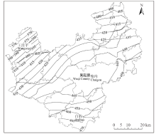
以中国气象数据网(http://data.cma.cn/)黄土高原及其周边地区各个气象站点1981-2010年的年均降水量为依据, 采用ArcGIS软件中的反距离加权(inverse distance weighted, IDW)插值法绘制陕西省吴起县的降水等值线图(图1)。由此可见, 吴起全县降水量从东南部到西北部总体呈现递减的趋势, 其中白豹、柴沟及王洼子研究样地年均降水量分别为460~470 mm、440~445 mm和370~395 mm。

图1 研究区降水等值线图Fig.1 The contour map of precipitation in study area

2.2 土壤含水量分析

随土层深度的增加, 王洼子、柴沟和白豹的土壤含水量总体呈下降趋势, 其中王洼子0~40 cm土层土壤含水量显著高于60~100 cm土层含水量(P< 0.05), 而柴沟和白豹不同土层土壤含水量则没有显著差异(图2)。从不同区域来看, 王洼子、柴沟和白豹浅层(0~100 cm)土壤含水量分别为8.7%、12.7%和14.4%, 除20~40 cm土层3个区域土壤含水量无显著差异外, 王洼子其他土层土壤含水量均显著低于柴沟和白豹。这表明上述3个区域浅层土壤含水量与年均降水量密切相关。

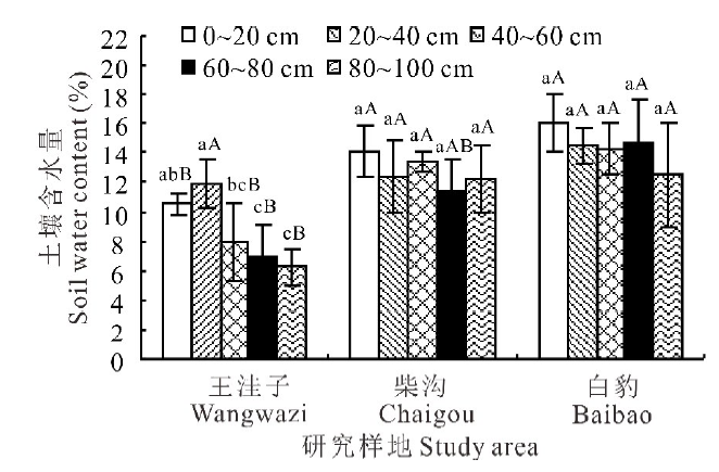
图2 不同区域土壤含水量随土层深度变化特征
图中不同小写字母表示同一区域不同土层土壤含水量差异显著(P< 0.05), 不同大写字母表示同一土层不同区域土壤含水量差异显著(P< 0.05)。
Fig.2 The change of soil water content with soil depth in different areas
Different small letters indicate significant differences of soil water content in same region with different soil layer (P< 0.05), different capital letters indicate significant differences of soil water content in different regions with same soil layer (P< 0.05).

2.3 植被群落物种组成分析

王洼子、柴沟及白豹3个区域共调查植物20科47属57种, 其中菊科8属13种, 禾本科10属11种, 蔷薇科7属10种, 豆科4属5种, 上述4科植物分别占调查属和种的61.7%和68.4%, 这表明该地区多数物种均属于菊科、禾本科、蔷薇科和豆科。此外, 3个区域植被群落中, 乔木物种共有8科11属11种, 灌木物种共有4科7属8种, 草本物种共有12科29属38种。由不同区域草本植物群落主要物种重要值分析可知, 针茅(Stipa capillata)、冷蒿(Artemisia frigida)和铁杆蒿(Artemisia gmelinii)为王洼子地区草本群落的建群种, 铁杆蒿、长芒草(Stipa bungeana)和大萼委陵菜(Potentilla conferta)则是柴沟地区草本群落的建群种, 而黄蒿(Artemisia scoparia)、铁杆蒿和赖草(Leymus secalinus)则是白豹地区草本群落的建群种(表2)。

表2 不同区域草本植物群落主要物种重要值 Table 2 Important values of main species of herbage community in different areas
2.4 植被群落物种多样性分析

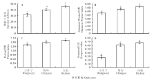
不同区域植被的物种丰富度、Shannon-Wiener指数、Pielou指数及Simpson指数从高到低均依次为白豹> 柴沟> 王洼子, 且3个区域植被物种丰富度、Shannon-Wiener指数及Pielou指数彼此间均存在显著差异(P< 0.05), 此外白豹和柴沟植被的Simpson指数也显著高于王洼子(图3)。不同区域植被群落Sorensen指数分析表明, 王洼子和柴沟、王洼子和白豹、柴沟和白豹间的Sorensen指数分别为0.62、0.63、0.75, 由此可见不同区域植被群落物种组成具有较高的相似性。这表明该地区植被群落物种丰富度和多样性随着降水量的下降逐渐降低, 但物种组成并未发生较大变化。

图3 不同区域植被群落物种多样性变化特征
不同小写字母表示不同区域差异显著(P< 0.05)。
Fig.3 Species diversity change characteristics of vegetation communities in different areas
Different small letters indicate significant differences in different regions (P< 0.05).

2.5 植被群落多样性与土壤含水量间的相关性分析

植被群落多样性指数与不同深度土壤含水量间的相关性分析结果表明(表3), 物种丰富度、Shannon-Wiener指数、Pielou指数及Simpson指数与不同深度土壤含水量均具有极显著(P< 0.01)或显著(P< 0.05)的正相关性, 并且物种丰富度、Shannon-Wiener指数、Simpson指数及Pielou指数与0~20 cm土层土壤含水量间的相关系数最高。这表明该地区植被群落物种多样性与土壤含水量密切相关, 尤其是表层土壤的含水量。

表3 植被群落多样性与土壤含水量间的相关性 Table 3 Correlation between vegetation diversity and soil water content
3 讨论

黄土高原降水分布受地形地貌的影响自东南向西北呈现递减的趋势, 这种降水格局控制着多数生态过程[28]。土壤水分的时空异质性是由地形、气候、植被等环境因子共同作用的结果, 其主导因子因研究区域和研究尺度变化而存在一定的差异[29]。研究表明, 降水是半干旱黄土丘陵区土壤水分最主要的来源[30]。本研究对陕北吴起县降水分布特征的分析表明其降水量自东南向西北逐渐降低, 而这种降水分布特征也使得3个研究区域土壤浅层水分呈现显著差异, 且随着降水量的减少而降低。张钦弟等[31]对黄土高原草地土壤水分沿降水梯度变化特征的研究结果也同样证实了这一观点。这表明降水是影响上述区域土壤水分空间异质性的主导因子。然而, 本研究中在降水量相对较高的白豹和柴沟研究区不同土层土壤含水量并未呈现显著差异, 而降水量相对较低的王洼子研究区表层土壤水分则显著较高, 这是否与降水量及土壤入渗能力等因素有关, 还有待于进一步深入研究。

植物种类和物种重要值不仅可以体现群落组成结构的差异, 还能够较为全面地反映不同物种在群落中的功能地位及分布格局[32, 33]。本研究调查发现该地区植被群落主要隶属菊科、禾本科、蔷薇科和豆科, 且以草本植物为主, 这与陈文思等[22]、刘中奇等[26]的研究结果相一致。在黄土高原地区, 草本植物的种类、多度和高度会受到降水格局的影响, 从而影响植物群落的分布与结构[34]。本研究中草本植物的重要值随着降水量的改变也发生了明显变化, 如耐旱植物针茅已成为王洼子的优势种。这主要是由于降水减少直接降低了土壤有效水分, 并通过限制根际微生物的正常活动间接影响养分的吸收、运输和利用[35]

群落多样性作为生物群落的重要特征, 能够有效反映群落自身特征及其与环境之间的相互关系[27]。本研究表明, 不同研究区域群落多样性指数存在显著差异, 且植被群落多样性指数与土壤含水量呈显著的正相关性。张钦弟等[31]研究表明, 黄土高原草地物种丰富度和多样性指数随降水减少呈现显著的递减趋势。郝文芳等[20]研究发现, 土壤水分对黄土丘陵区植物群落的结构组成和多样性起着关键性的作用。张志南等[34]研究指出, 黄土高原天然草地群落物种多样性与土壤含水量之间具有显著的正相关关系。由此可见, 降水对植物群落特征的影响主要是通过改变土壤水分来实现的, 而土壤水分的改变又会进一步影响植被群落的结构和功能。此外, 植被群落多样性指数与0~20 cm土壤含水量的相关系数明显高于与其他深度土壤含水量的相关系数, 这可能与研究区植被类型以草本为主, 其根系主要分布于0~20 cm土层有关。

4 结论

陕北吴起县降水分布自东南向西北逐渐减少, 植被群落主要隶属菊科、禾本科、蔷薇科和豆科, 且以草本植物为主。随着降水量的减少, 3个典型区域草本植物的重要值发生了明显变化, 但植被群落物种组成具有较高的相似性, 土壤含水量、植被群落物种丰富度、Shannon-Wiener指数、Pielou指数及Simpson指数均呈降低趋势, 且植被群落物种多样性指数与土壤含水量具有显著的正相关关系。

参考文献
[1] Tang K L. Importance and urgency of harnessing the interlocked area with both water and wind erosion in the Loess Plateau. Soil and Water Conservation in China, 2000, (11): 11-12, 17.
唐克丽. 黄土高原水蚀风蚀交错区治理的重要性与紧迫性. 中国水土保持, 2000, (11): 11-12, 17. [本文引用:1]
[2] Qin W, Zhu Q K, Zhang Y Q, et al. Dynamics of plant community species diversity in the process of ecological rehabilitation in north Shaanxi loess area. Chinese Journal of Applied Ecology, 2009, 20(2): 403-409.
秦伟, 朱清科, 张宇清, . 陕北黄土区生态修复过程中植物群落物种多样性变化. 应用生态学报, 2009, 20(2): 403-409. [本文引用:2]
[3] Liu G C, Huang Y X, Wang Q G, et al. Effects of environmental factors on plant species diversity: Research progress. Chinese Agricultural Science Bulletin, 2018, 34(13): 83-89.
刘冠成, 黄雅曦, 王庆贵, . 环境因子对植物物种多样性的影响研究进展. 中国农学通报, 2018, 34(13): 83-89. [本文引用:1]
[4] Sim-Sim M, Lopes T, Ruas S, et al. Does altitude shape molecular diversity and richness of bryophytes in Madeira’s natural forest? A case study with four bryophyte species at two altitudinal levels. Plant Ecology and Evolution, 2015, 148(2): 171-180. [本文引用:1]
[5] Li C J, Sun Q, Chen Z, et al. Effects of roadside slope gradient on plant diversity during revegetation. Bulletin of Botanical Research, 2013, 33(4): 477-483.
李成俊, 孙琦, 陈璋, . 道路边坡坡度对植被恢复中物种多样性的影响研究. 植物研究, 2013, 33(4): 477-483. [本文引用:1]
[6] Liu Z X, Ren G X, Kang B, et al. The species diversities under secondary forest communities on different slope aspects in Xinjiashan Mountain. Research of Soil and Water Conservation, 2011, 18(4): 197-202.
刘振学, 任广鑫, 康冰, . 辛家山不同坡向次生林群落物种多样性研究. 水土保持研究, 2011, 18(4): 197-202. [本文引用:1]
[7] Feng Y, Ma K M, Zhang Y X, et al. Effects of slope position on species abundance distribution of Quercus wutaishanica community in Dongling Mountain of Beijing. Chinese Journal of Ecology, 2011, 30(10): 2137-2144.
冯云, 马克明, 张育新, . 坡位对北京东灵山辽东栎林物种多度分布的影响. 生态学杂志, 2011, 30(10): 2137-2144. [本文引用:1]
[8] Wu H, Wang D X, Huang Q P, et al. Influence of environmental factors on species diversity of pine-oak mixed forest in the middle part of south Qinling Mountains. Journal of Northwest A&F University (Natural Science Edition), 2012, 40(9): 41-50.
吴昊, 王得祥, 黄青平, . 环境因子对秦岭南坡中段松栎混交林物种多样性的影响. 西北农林科技大学学报(自然科学版), 2012, 40(9): 41-50. [本文引用:1]
[9] Cachovanová L, Hájek M, Fajmonová Z, et al. Species richness, community specialization and soil-vegetation relationships of managed grassland s in a geologically heterogeneous land scape. Folia Geobotanica, 2012, 47(4): 349-371. [本文引用:1]
[10] Wang S X, Wang X A, Li G Q, et al. Species diversity and environmental interpretation in the process of community succession in the Ziwu Mountain of Shaanxi Province. Acta Ecologica Sinica, 2010, 30(6): 1638-1647.
王世雄, 王孝安, 李国庆, . 陕西子午岭植物群落演替过程中物种多样性变化与环境解释. 生态学报, 2010, 30(6): 1638-1647. [本文引用:1]
[11] Zelnik I, Carni A. Plant species diversity and composition of wet grassland s in relation to environmental factors. Biodiversity and Conservation, 2013, 22(10): 2179-2192. [本文引用:2]
[12] Wu J S, Li X J, Shen Z X, et al. Species diversity distribution pattern of alpine grassland s communities along a precipitation gradient across Northern Tibetan Plateau. Acta Prataculturae Sinica, 2012, 21(3): 17-25.
武建双, 李晓佳, 沈振西, . 藏北高寒草地样带物种多样性沿降水梯度的分布格局. 草业学报, 2012, 21(3): 17-25. [本文引用:2]
[13] Irl S D H, Harter D E V, Steinbauer M J, et al. Climate vs. topography-spatial patterns of plant species diversity and endemism on a high-elevation island . Journal of Ecology, 2015, 103(6): 1621-1633. [本文引用:1]
[14] Zhao X F, Xu H L, Zhang P, et al. Effects of nutrient and water additions on plant community structure and species diversity in desert grassland s. Chinese Journal of Plant Ecology, 2014, 38(2): 167-177.
赵新风, 徐海量, 张鹏, . 养分与水分添加对荒漠草地植物群落结构和物种多样性的影响. 植物生态学报, 2014, 38(2): 167-177. [本文引用:1]
[15] Wang M, Xu B, Zhang D Y, et al. Changes in plant community biomass and biodiversity along soil moisture content gradients in Xilin River basin, Inner Mongolia. Journal of Beijing Normal University (Natural Science), 2016, 52(4): 445-449.
王萌, 徐冰, 张大勇, . 内蒙古草原锡林河流域植物群落生物量及多样性沿土壤水分含量梯度的变化. 北京师范大学学报(自然科学版), 2016, 52(4): 445-449. [本文引用:1]
[16] Mcguire K L, Treseder K. Microbial communities and their relevance for ecosystem models: Decomposition as a case study. Soil Biology and Biochemistry, 2010, 42(4): 529-535. [本文引用:1]
[17] Li X Y, Duan Z H. Review on the interaction between soil moisture and vegetation on the Loess Plateau. Chinese Journal of Soil Science, 2012, 43(6): 1508-1514.
李小英, 段争虎. 黄土高原土壤水分与植被相互作用研究进展. 土壤通报, 2012, 43(6): 1508-1514. [本文引用:1]
[18] Zou H, Gao G Y, Fu B J. The relationship between grassland ecosystem and soil water in arid and semi-arid areas: A review. Acta Ecologica Sinica, 2016, 36(11): 3127-3136.
邹慧, 高光耀, 傅伯杰. 干旱半干旱草地生态系统与土壤水分关系研究进展. 生态学报, 2016, 36(11): 3127-3136. [本文引用:1]
[19] Sinoga J D R, Galeote M A G, Murillo J F M, et al. Vegetation strategies for soil water consumption along a pluviometric gradient in southern Spain. Catena, 2010, 84(1): 12-20. [本文引用:1]
[20] Hao W F, Du F, Chen X Y, et al. Composition and diversity analysis of natural-community plants in the loess hilly region. Acta Agrestia Sinica, 2012, 20(4): 609-615.
郝文芳, 杜峰, 陈小燕, . 黄土丘陵区天然群落的植物组成、植物多样性及其与环境因子的关系. 草地学报, 2012, 20(4): 609-615. [本文引用:2]
[21] Li Z Y, Zhao X K, Zhu Q K. Saturation of available soil water for micro-topography in loess area of north Shaanxi. Agricultural Research in the Arid Areas, 2017, 35(4): 88-94.
李增尧, 赵兴凯, 朱清科. 陕北黄土区微地形土壤有效水饱和度. 干旱地区农业研究, 2017, 35(4): 88-94. [本文引用:2]
[22] Chen W S, Zhu Q K, Lu J Y, et al. Plant diversity with natural recovery on different topographies in north Shaanxi loess area. Science of Soil and Water Conservation, 2016, 14(2): 103-110.
陈文思, 朱清科, 卢纪元, . 陕北黄土区不同地形自然恢复的植物多样性. 中国水土保持科学, 2016, 14(2): 103-110. [本文引用:3]
[23] Tan X, Zhu Q K, Xie R, et al. On diversity of plants & their response to terrain in loess of north Shaanxi. Journal of Mianyang Normal University, 2011, 30(2): 92-100.
谭枭, 朱清科, 谢芮, . 陕北黄土区封育流域植物多样性及对地形的响应研究. 绵阳师范学院学报, 2011, 30(2): 92-100. [本文引用:1]
[24] Zhang X P, Yang G H, Wang H Z, et al. Species diversity and community characteristics of different vegetation during restoration in the gully region of Loess Plateau. Journal of Northwest Forestry University, 2011, 26(2): 22-25.
张笑培, 杨改河, 王和洲, . 黄土沟壑区不同植被恢复群落特征及多样性研究. 西北林学院学报, 2011, 26(2): 22-25. [本文引用:1]
[25] Zhang T, Wang Y J, Wang Y Q, et al. Plant diversity in various forest community types in the Loess Plateau of western Shanxi Province, northern China. Journal of Beijing Forestry University, 2015, 37(11): 82-88.
张桐, 王玉杰, 王云琦, . 晋西黄土区不同森林群落类型植物多样性研究. 北京林业大学学报, 2015, 37(11): 82-88. [本文引用:1]
[26] Liu Z Q, Zhu Q K, Qin W, et al. Comparison of vegetation community between natural recovery and artificial restoration in semiarid loess area. Ecology and Environmental Sciences, 2010, 19(4): 857-863.
刘中奇, 朱清科, 秦伟, . 半干旱黄土区自然恢复与人工造林恢复植被群落对比研究. 生态环境学报, 2010, 19(4): 857-863. [本文引用:3]
[27] Fang J Y, Wang X P, Shen Z H, et al. Methods and protocols for plant community inventory. Biodiversity Science, 2009, 17(6): 533-548.
方精云, 王襄平, 沈泽昊, . 植物群落清查的主要内容、方法和技术规范. 生物多样性, 2009, 17(6): 533-548. [本文引用:2]
[28] Wang Y Q, Shao M A, Zhu Y J, et al. Impacts of land use and plant characteristics on dried soil layers in different climatic regions on the Loess Plateau of China. Agricultural and Forest Meteorology, 2011, 151(4): 437-448. [本文引用:1]
[29] Qiu Y, Fu B J, Wang J, et al. Spatiotemporal variation of soil moisture and its relation to environmental factor. Chinese Journal of Ecology, 2007, 26(1): 100-107.
邱扬, 傅伯杰, 王军, . 土壤水分时空变异及其与环境因子的关系. 生态学杂志, 2007, 26(1): 100-107. [本文引用:1]
[30] Ai N, Qiang F F, Zhu Q K, et al. Dynamic analysis for soil moisture during the rainy season at semiarid loess hilly region. Chinese Journal of Soil Science, 2017, 48(2): 326-334.
艾宁, 强方方, 朱清科, . 半干旱黄土丘陵区雨季土壤水分动态分析. 土壤通报, 2017, 48(2): 326-334. [本文引用:1]
[31] Zhang Q D, Wei W, Chen L D, et al. Spatial variation of soil moisture and species diversity patterns along a precipitation gradient in the grassland s of the Loess Plateau. Journal of Natural Resources, 2018, 33(8): 1351-1362.
张钦弟, 卫伟, 陈利顶, . 黄土高原草地土壤水分和物种多样性沿降水梯度的分布格局. 自然资源学报, 2018, 33(8): 1351-1362. [本文引用:2]
[32] Yue Y J, Yu X X, Niu L L, et al. Structural characteristics of plant communities and species diversity in Wuling Mountain, Beijing. Journal of Beijing Forestry University, 2008, 30(S2): 165-170.
岳永杰, 余新晓, 牛丽丽, . 北京雾灵山植物群落结构及物种多样性特征. 北京林业大学学报, 2008, 30(S2): 165-170. [本文引用:1]
[33] Lou Y J, Zhao K Y, Hu J M. Species diversity of typical wetland plant communities in Sanjiang Plain. Chinese Journal of Ecology, 2006, 25(4): 364-368.
娄彦景, 赵魁义, 胡金明. 三江平原湿地典型植物群落物种多样性研究. 生态学杂志, 2006, 25(4): 364-368. [本文引用:1]
[34] Zhang Z N, Wu G L, Wang D, et al. Plant community structure and soil moisture in the semi-arid natural grassland of the Loess Plateau. Acta Prataculturae Sinica, 2014, 23(6): 313-319.
张志南, 武高林, 王冬, . 黄土高原半干旱区天然草地群落结构与土壤水分关系. 草业学报, 2014, 23(6): 313-319. [本文引用:2]
[35] Clark J S, Campbell J H, Grizzle H, et al. Soil microbial community response to drought and precipitation variability in the Chihuahuan Desert. Microbial Ecology, 2009, 57(2): 248-260. [本文引用:1]