

ISSN 1004-5759 CN 62-1105/S
草业学报 ›› 2026, Vol. 35 ›› Issue (7): 1-14.DOI: 10.11686/cyxb2025297
• 研究论文 •
黄埔1,2( ), 黄青1,2(), 辛晓平1,2
收稿日期:2025-07-17
修回日期:2025-09-03
出版日期:2026-07-20
发布日期:2026-05-21
通讯作者:
黄青
作者简介:Corresponding author. E-mail: huangqing@caas.cn基金资助:
Pu HUANG1,2(), Qing HUANG1,2(), Xiao-ping XIN1,2
Received:2025-07-17
Revised:2025-09-03
Online:2026-07-20
Published:2026-05-21
Contact:
Qing HUANG
摘要:
天然打草场作为半干旱牧区草地资源的重要组成部分,对维持草地生态系统的稳定与可持续发展具有重要意义。然而,长期以来,我国天然打草场空间分布数据匮乏,现有数据难以准确反映其现状,制约了草地资源的科学管理与保护。为解决这一问题,本研究基于多源遥感数据融合技术(Sentinel-2与Landsat-8影像),引入地形、光谱指数和纹理特征,采用面向对象分割和支持向量机(support vector machine, SVM)算法,对半干旱牧区天然打草场进行了高精度遥感提取。研究结果显示,2020-2022年间半干旱牧区天然打草场总面积为794.92万hm2,其中内蒙古北部牧区占比最大(81.19%),温性草原为主要打草类型(61.87%)。固定打草场和机动打草场面积分别为477.12万和317.80万hm2,占比分别为60.02%和39.98%,空间分布呈现明显区域差异。遥感提取总体精度达84.76%,Kappa系数为0.69,与地面调查数据一致性较高,其中内蒙古北部牧区精度最高(87.16%)。本研究填补了近10年来天然打草场空间分布数据的空白,为草地资源的科学管理、生态保护与可持续利用提供了可靠的数据支持。
黄埔, 黄青, 辛晓平. 中国半干旱牧区天然打草场空间格局遥感提取与分析[J]. 草业学报, 2026, 35(7): 1-14.
Pu HUANG, Qing HUANG, Xiao-ping XIN. Remote sensing extraction and analysis of the spatial pattern of natural cutting pastures in semi-arid pastoral areas of China[J]. Acta Prataculturae Sinica, 2026, 35(7): 1-14.
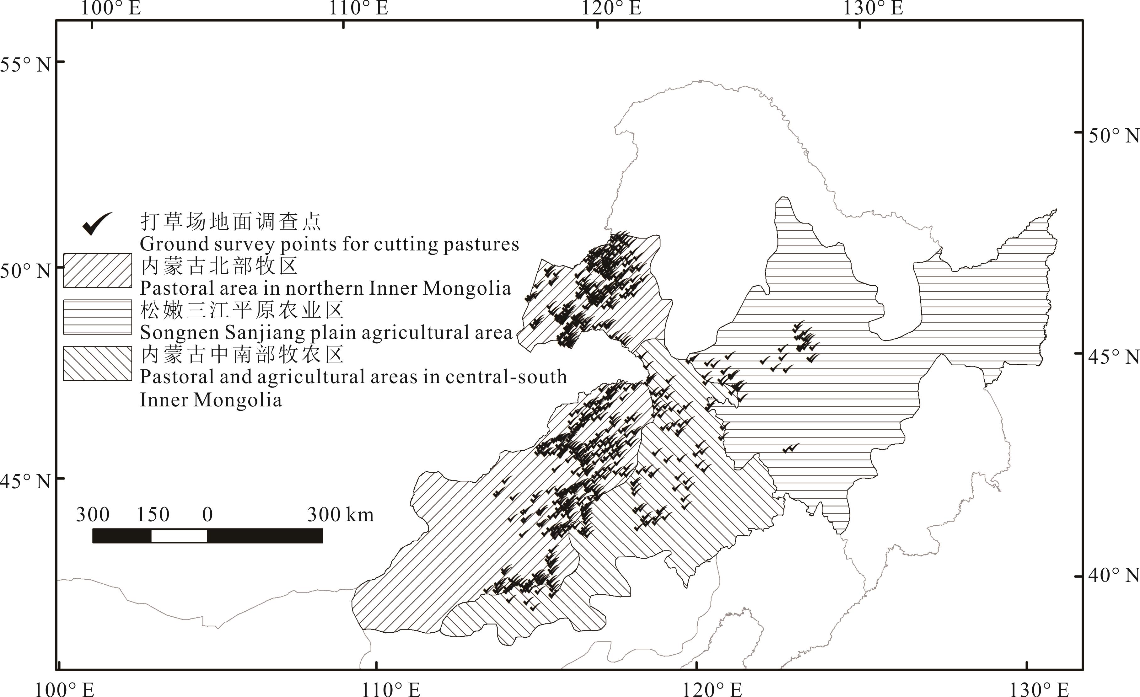
图1 研究区区位基于自然资源部标准地图服务网站GS(2024)0650号标准地图制作,底图边界无修改。Produced based on the standard map GS(2024)0650 from the Standard Map Service website of the Ministry of Natural Resources, with no modifications to the base map boundaries.
Fig.1 Location of the study area
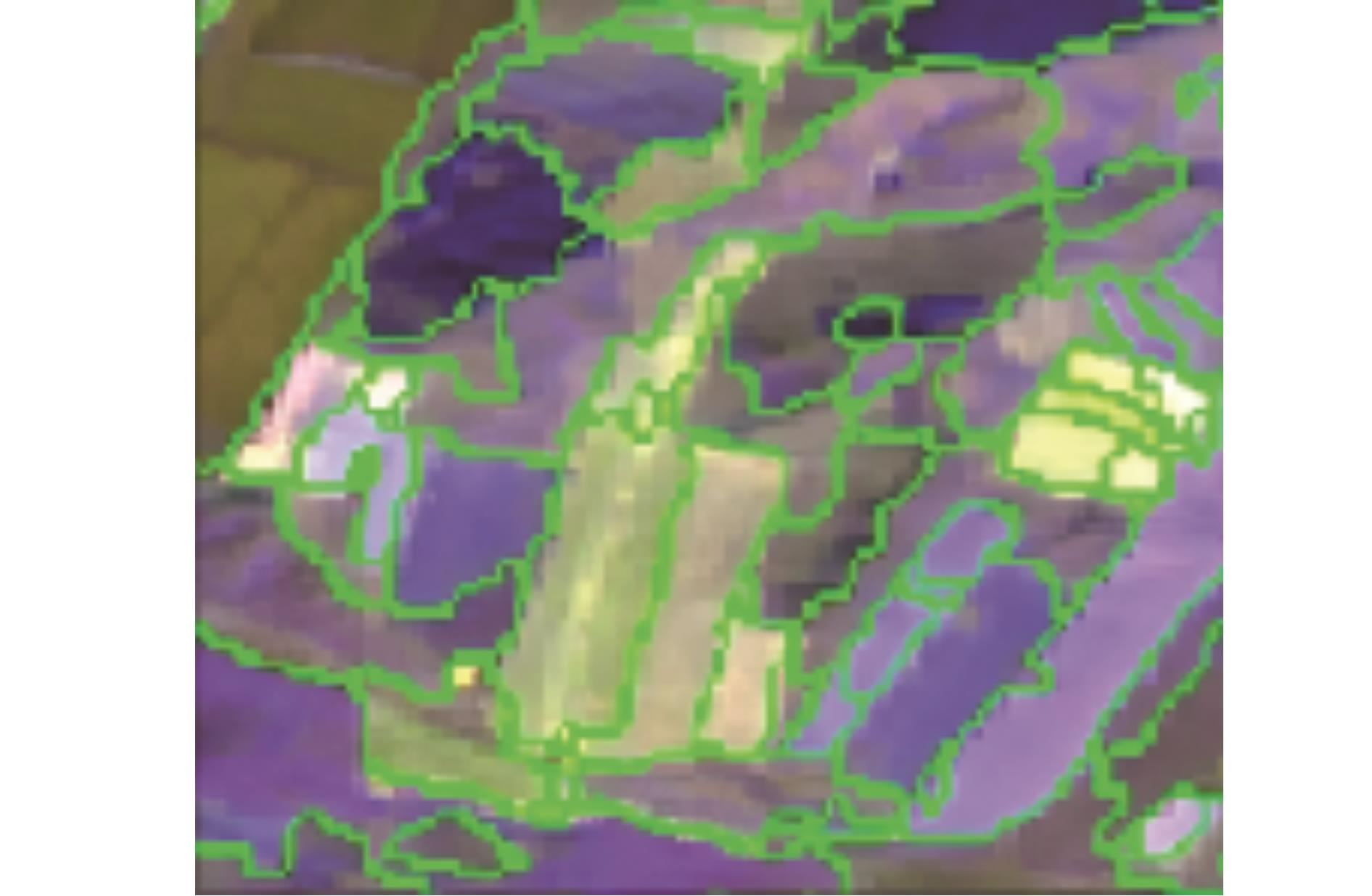
图2 图像分割效果
Fig.2 Effect of image segmentation
| 地物类别Land cover | 二级地类Second land class |
|---|---|
| 耕地Cropland | 水田Paddy field, 旱地Dryland, 水浇地Irrigated land |
| 林地Forest | 乔木林地Arbor forest land, 竹林地Bamboo forest land, 森林沼泽Forest marsh, 灌木林地Shrub forest land, 灌丛沼泽Shrub marsh, 其他林地Other forest land |
| 刈割草地Cutting pasture | 刈割草地Cutting pasture |
| 牧草地Grazing pasture | 牧草地Grazing pasture |
| 沼泽草地Marsh grassland | 沼泽草地Marsh grassland |
| 其他草地Other grassland | 其他草地Other grassland |
| 水域Water | 河流水面River water surface, 湖泊水面Lake water surface, 水库水面Reservoir water surface, 坑塘水面Pond water surface, 沟渠Ditch, 沼泽地Marshland, 冰川及永久积雪Glacier and permanent snow cover |
| 建设用地Building land | 零售商业用地Retail commercial land, 批发市场用地Wholesale market land, 餐饮用地Catering land, 旅馆用地Hotel land, 商务金融用地Commercial and financial land, 娱乐用地Entertainment land, 其他商服用地Other commercial service land, 工业用地Industrial land, 仓储用地Warehousing land, 城镇住宅用地Urban residential land, 农村宅基地Rural homestead |
| 未利用地Barren | 空闲地Vacant land, 盐碱地Saline-alkali land, 沙地Sandy land, 裸土地Bare land |
表1 研究区地物类别划分
Table 1 Land cover classification in the study area
| 地物类别Land cover | 二级地类Second land class |
|---|---|
| 耕地Cropland | 水田Paddy field, 旱地Dryland, 水浇地Irrigated land |
| 林地Forest | 乔木林地Arbor forest land, 竹林地Bamboo forest land, 森林沼泽Forest marsh, 灌木林地Shrub forest land, 灌丛沼泽Shrub marsh, 其他林地Other forest land |
| 刈割草地Cutting pasture | 刈割草地Cutting pasture |
| 牧草地Grazing pasture | 牧草地Grazing pasture |
| 沼泽草地Marsh grassland | 沼泽草地Marsh grassland |
| 其他草地Other grassland | 其他草地Other grassland |
| 水域Water | 河流水面River water surface, 湖泊水面Lake water surface, 水库水面Reservoir water surface, 坑塘水面Pond water surface, 沟渠Ditch, 沼泽地Marshland, 冰川及永久积雪Glacier and permanent snow cover |
| 建设用地Building land | 零售商业用地Retail commercial land, 批发市场用地Wholesale market land, 餐饮用地Catering land, 旅馆用地Hotel land, 商务金融用地Commercial and financial land, 娱乐用地Entertainment land, 其他商服用地Other commercial service land, 工业用地Industrial land, 仓储用地Warehousing land, 城镇住宅用地Urban residential land, 农村宅基地Rural homestead |
| 未利用地Barren | 空闲地Vacant land, 盐碱地Saline-alkali land, 沙地Sandy land, 裸土地Bare land |
农业区 Agricultural region | 各地类的样本数量Number of samples in each class | ||||||||
|---|---|---|---|---|---|---|---|---|---|
耕地 Cropland | 林地 Forest | 刈割草地 Cutting pasture | 牧草地 Grazing pasture | 沼泽草地 Marsh grassland | 其他草地 Other grassland | 水域 Water | 建设用地 Building land | 未利 用地 Barren | |
| 内蒙古北部牧区Pastoral area in northern Inner Mongolia | 100 | 50 | 400 | 150 | 100 | 300 | 30 | 50 | 50 |
| 内蒙古中南部牧农区Pastoral and agricultural areas in central-south Inner Mongolia | 200 | 150 | 250 | 100 | 60 | 80 | 30 | 50 | 50 |
| 松嫩三江平原农业区Songnen Sanjiang plain agricultural area | 400 | 100 | 100 | 80 | 60 | 120 | 30 | 50 | 50 |
表2 各农业区地物样本数量
Table 2 The number of samples in each agricultural region
农业区 Agricultural region | 各地类的样本数量Number of samples in each class | ||||||||
|---|---|---|---|---|---|---|---|---|---|
耕地 Cropland | 林地 Forest | 刈割草地 Cutting pasture | 牧草地 Grazing pasture | 沼泽草地 Marsh grassland | 其他草地 Other grassland | 水域 Water | 建设用地 Building land | 未利 用地 Barren | |
| 内蒙古北部牧区Pastoral area in northern Inner Mongolia | 100 | 50 | 400 | 150 | 100 | 300 | 30 | 50 | 50 |
| 内蒙古中南部牧农区Pastoral and agricultural areas in central-south Inner Mongolia | 200 | 150 | 250 | 100 | 60 | 80 | 30 | 50 | 50 |
| 松嫩三江平原农业区Songnen Sanjiang plain agricultural area | 400 | 100 | 100 | 80 | 60 | 120 | 30 | 50 | 50 |
| 农业区Agricultural region | 总体精度Overall accuracy (%) | Kappa系数Kappa coefficient |
|---|---|---|
| 内蒙古北部牧区Pastoral area in northern Inner Mongolia | 87.16 | 0.74 |
| 内蒙古中南部牧农区Pastoral and agricultural areas in central-south Inner Mongolia | 81.12 | 0.61 |
| 松嫩三江平原农业区Songnen Sanjiang plain agricultural area | 77.10 | 0.51 |
| 半干旱牧区总体情况General overview of semi-arid pastoral region | 84.76 | 0.69 |
表3 打草场遥感提取精度评价
Table 3 Accuracy assessment of remote sensing extraction for cutting pastures
| 农业区Agricultural region | 总体精度Overall accuracy (%) | Kappa系数Kappa coefficient |
|---|---|---|
| 内蒙古北部牧区Pastoral area in northern Inner Mongolia | 87.16 | 0.74 |
| 内蒙古中南部牧农区Pastoral and agricultural areas in central-south Inner Mongolia | 81.12 | 0.61 |
| 松嫩三江平原农业区Songnen Sanjiang plain agricultural area | 77.10 | 0.51 |
| 半干旱牧区总体情况General overview of semi-arid pastoral region | 84.76 | 0.69 |
打草场类型 Types of cutting pastures | 二级农业区 Secondary agricultural region | 低地草甸 Lowland meadow | 温性草甸草原 Temperate meadow grassland | 温性草原 Temperate grassland | 温性山地草原 Temperate mountain grassland | 其他 类型 Other types | |
|---|---|---|---|---|---|---|---|
固定打草场 Fixed cutting pasture | 松嫩三江平原农业区Songnen Sanjiang plain agricultural area | 面积Area (×104 hm2) | 1.30 | 2.62 | 0.27 | 4.18 | 4.95 |
| 所占比例Proportion (%) | 0.16 | 0.33 | 0.03 | 0.53 | 0.62 | ||
| 内蒙古北部牧区Pastoral area in northern Inner Mongolia | 面积Area (×104 hm2) | 41.43 | 60.61 | 298.98 | 10.61 | 0.00 | |
| 所占比例Proportion (%) | 5.21 | 7.62 | 37.61 | 1.33 | 0.00 | ||
| 内蒙古中南部牧农区Pastoral and agricultural areas in central-south Inner Mongolia | 面积Area (×104 hm2) | 10.87 | 6.27 | 19.37 | 15.40 | 0.25 | |
| 所占比例Proportion (%) | 1.37 | 0.79 | 2.44 | 1.94 | 0.03 | ||
机动打草场 Mobile cutting pasture | 松嫩三江平原农业区Songnen Sanjiang plain agricultural area | 面积Area (×104 hm2) | 3.38 | 7.92 | 0.66 | 3.24 | 12.05 |
| 所占比例Proportion (%) | 0.43 | 1.00 | 0.08 | 0.41 | 1.52 | ||
| 内蒙古北部牧区Pastoral area in northern Inner Mongolia | 面积Area (×104 hm2) | 31.56 | 34.77 | 154.71 | 12.72 | 0.00 | |
| 所占比例Proportion (%) | 3.97 | 4.37 | 19.46 | 1.60 | 0.00 | ||
| 内蒙古中南部牧农区Pastoral and agricultural areas in central-south Inner Mongolia | 面积Area (×104 hm2) | 12.07 | 5.99 | 17.85 | 20.81 | 0.06 | |
| 所占比例Proportion (%) | 1.52 | 0.75 | 2.25 | 2.62 | 0.01 |
表4 各农业区打草场面积
Table 4 Cutting pasture area of each agricultural region
打草场类型 Types of cutting pastures | 二级农业区 Secondary agricultural region | 低地草甸 Lowland meadow | 温性草甸草原 Temperate meadow grassland | 温性草原 Temperate grassland | 温性山地草原 Temperate mountain grassland | 其他 类型 Other types | |
|---|---|---|---|---|---|---|---|
固定打草场 Fixed cutting pasture | 松嫩三江平原农业区Songnen Sanjiang plain agricultural area | 面积Area (×104 hm2) | 1.30 | 2.62 | 0.27 | 4.18 | 4.95 |
| 所占比例Proportion (%) | 0.16 | 0.33 | 0.03 | 0.53 | 0.62 | ||
| 内蒙古北部牧区Pastoral area in northern Inner Mongolia | 面积Area (×104 hm2) | 41.43 | 60.61 | 298.98 | 10.61 | 0.00 | |
| 所占比例Proportion (%) | 5.21 | 7.62 | 37.61 | 1.33 | 0.00 | ||
| 内蒙古中南部牧农区Pastoral and agricultural areas in central-south Inner Mongolia | 面积Area (×104 hm2) | 10.87 | 6.27 | 19.37 | 15.40 | 0.25 | |
| 所占比例Proportion (%) | 1.37 | 0.79 | 2.44 | 1.94 | 0.03 | ||
机动打草场 Mobile cutting pasture | 松嫩三江平原农业区Songnen Sanjiang plain agricultural area | 面积Area (×104 hm2) | 3.38 | 7.92 | 0.66 | 3.24 | 12.05 |
| 所占比例Proportion (%) | 0.43 | 1.00 | 0.08 | 0.41 | 1.52 | ||
| 内蒙古北部牧区Pastoral area in northern Inner Mongolia | 面积Area (×104 hm2) | 31.56 | 34.77 | 154.71 | 12.72 | 0.00 | |
| 所占比例Proportion (%) | 3.97 | 4.37 | 19.46 | 1.60 | 0.00 | ||
| 内蒙古中南部牧农区Pastoral and agricultural areas in central-south Inner Mongolia | 面积Area (×104 hm2) | 12.07 | 5.99 | 17.85 | 20.81 | 0.06 | |
| 所占比例Proportion (%) | 1.52 | 0.75 | 2.25 | 2.62 | 0.01 |

图3 内蒙古北部牧区的天然打草场分布基于自然资源部标准地图服务网站GS(2024)0650号标准地图制作,底图边界无修改。Produced based on the standard map GS(2024)0650 from the Standard Map Service website of the Ministry of Natural Resources, with no modifications to the base map boundaries.
Fig.3 Distribution of natural cutting pastures in the pastoral area in northern Inner Mongolia
行政区 Administrative region | 打草场面积 Area of cutting pastures | 固定打草场面积 Area of fixed cutting pastures | 机动打草场面积 Area of mobile cutting pastures | 行政区 Administrative region | 打草场面积 Area of cutting pastures | 固定打草场面积 Area of fixed cutting pastures | 机动打草场面积 Area of mobile cutting pastures |
|---|---|---|---|---|---|---|---|
| 东乌珠穆沁旗East Uzhumuqin Banner | 181.39 | 132.29 | 49.10 | 苏尼特左旗Sunit Left Banner | 8.50 | 4.01 | 4.49 |
| 新巴尔虎右旗New Bal Tiger Right Banner | 85.21 | 41.94 | 43.27 | 镶黄旗Xianghuang Banner | 7.26 | 2.84 | 4.42 |
| 西乌珠穆沁旗West Uzhumuqin Banner | 83.48 | 61.67 | 21.81 | 正镶白旗Plain White Banner | 4.81 | 2.51 | 2.30 |
| 陈巴尔虎旗Chen Bal Tiger Banner | 68.60 | 41.68 | 26.92 | 正蓝旗Plain Blue Banner | 3.72 | 1.48 | 2.24 |
| 锡林浩特市Xilinhot City | 63.05 | 49.03 | 14.02 | 克什克腾旗Keshiketeng Banner | 2.90 | 2.10 | 0.80 |
| 新巴尔虎左旗New Bal Tiger Left Banner | 51.63 | 31.65 | 19.98 | 四子王旗Siziwang Banner | 1.42 | 0.60 | 0.82 |
| 阿巴嘎旗Abag Banner | 49.36 | 28.89 | 20.47 | 海拉尔区Hailar District | 1.29 | 0.29 | 1.00 |
| 鄂温克族自治旗Evenk Autonomous Banner | 20.10 | 7.18 | 12.92 | 额尔古纳市Ergun City | 1.00 | 0.49 | 0.51 |
| 苏尼特右旗Sunit Right Banner | 9.50 | 2.38 | 7.12 |
表5 内蒙古北部牧区的打草场面积
Table 5 Cutting pasture area in the pastoral area in northern Inner Mongolia (×104 hm2)
行政区 Administrative region | 打草场面积 Area of cutting pastures | 固定打草场面积 Area of fixed cutting pastures | 机动打草场面积 Area of mobile cutting pastures | 行政区 Administrative region | 打草场面积 Area of cutting pastures | 固定打草场面积 Area of fixed cutting pastures | 机动打草场面积 Area of mobile cutting pastures |
|---|---|---|---|---|---|---|---|
| 东乌珠穆沁旗East Uzhumuqin Banner | 181.39 | 132.29 | 49.10 | 苏尼特左旗Sunit Left Banner | 8.50 | 4.01 | 4.49 |
| 新巴尔虎右旗New Bal Tiger Right Banner | 85.21 | 41.94 | 43.27 | 镶黄旗Xianghuang Banner | 7.26 | 2.84 | 4.42 |
| 西乌珠穆沁旗West Uzhumuqin Banner | 83.48 | 61.67 | 21.81 | 正镶白旗Plain White Banner | 4.81 | 2.51 | 2.30 |
| 陈巴尔虎旗Chen Bal Tiger Banner | 68.60 | 41.68 | 26.92 | 正蓝旗Plain Blue Banner | 3.72 | 1.48 | 2.24 |
| 锡林浩特市Xilinhot City | 63.05 | 49.03 | 14.02 | 克什克腾旗Keshiketeng Banner | 2.90 | 2.10 | 0.80 |
| 新巴尔虎左旗New Bal Tiger Left Banner | 51.63 | 31.65 | 19.98 | 四子王旗Siziwang Banner | 1.42 | 0.60 | 0.82 |
| 阿巴嘎旗Abag Banner | 49.36 | 28.89 | 20.47 | 海拉尔区Hailar District | 1.29 | 0.29 | 1.00 |
| 鄂温克族自治旗Evenk Autonomous Banner | 20.10 | 7.18 | 12.92 | 额尔古纳市Ergun City | 1.00 | 0.49 | 0.51 |
| 苏尼特右旗Sunit Right Banner | 9.50 | 2.38 | 7.12 |
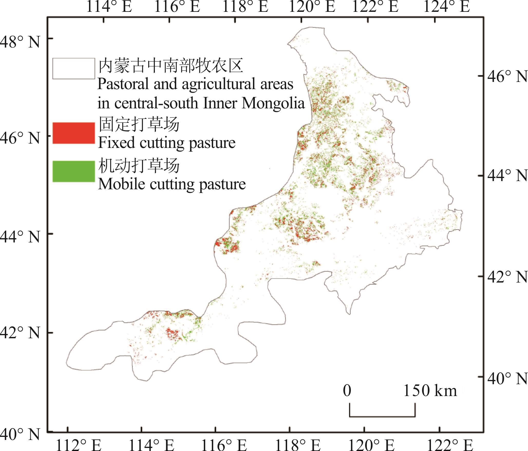
图4 内蒙古中南部牧农区的天然打草场分布基于自然资源部标准地图服务网站GS(2024)0650号标准地图制作,底图边界无修改。Produced based on the standard map GS(2024)0650 from the Standard Map Service website of the Ministry of Natural Resources, with no modifications to the base map boundaries.
Fig.4 Distribution of natural cutting pastures in the pastoral and agricultural areas in central-south Inner Mongolia
行政区 Administrative region | 打草场面积 Area of cutting pastures | 固定打草场面积 Area of fixed cutting pastures | 机动打草场面积 Area of mobile cutting pastures | |
|---|---|---|---|---|
| 赤峰市 Chifeng City | 39.76 | 18.93 | 20.83 | |
| 巴林右旗Bairin Right Banner | 14.10 | 7.84 | 6.26 | |
| 阿鲁科尔沁旗Ar Horqin Banner | 9.67 | 3.69 | 5.98 | |
| 克什克腾旗Hexigten Banner | 9.13 | 5.14 | 3.99 | |
| 巴林左旗Bairin Left Banner | 4.01 | 1.27 | 2.74 | |
| 翁牛特旗Ongniud Banner | 1.99 | 0.80 | 1.19 | |
| 通辽市 Tongliao City | 29.21 | 14.17 | 15.04 | |
| 扎鲁特旗Jarud Banner | 24.25 | 11.48 | 12.77 | |
| 霍林郭勒市Huolinguole City | 1.40 | 0.85 | 0.55 | |
| 科尔沁左翼后旗Horqin Left Rear Banner | 1.34 | 0.71 | 0.63 | |
| 科尔沁左翼中旗Horqin Left Middle Banner | 1.25 | 0.68 | 0.57 | |
| 兴安盟 Xing’an League | 25.69 | 11.00 | 14.69 | |
| 科尔沁右翼前旗Horqin Right Front Banner | 11.59 | 5.01 | 6.58 | |
| 科尔沁右翼中旗Horqin Right Middle Banner | 11.42 | 4.81 | 6.61 | |
| 突泉县Tuquan County | 1.80 | 0.67 | 1.13 | |
| 锡林郭勒盟 Xilin Gol League | 10.18 | 6.18 | 4.00 | |
| 太仆寺旗Taibus Banner | 3.55 | 2.62 | 0.93 | |
| 正镶白旗Plain White Banner | 1.94 | 1.06 | 0.88 | |
| 正蓝旗Plain Blue Banner | 1.68 | 0.70 | 0.98 | |
| 西乌珠穆沁旗West Uzhumuqin Banner | 1.48 | 0.89 | 0.59 | |
| 张家口市 Zhangjiakou City | 3.06 | 1.05 | 2.01 | |
| 康保县Kangbao County | 1.35 | 0.51 | 0.84 | |
| 沽源县Guyuan County | 1.30 | 0.13 | 1.17 | |
表6 内蒙古中南部牧农区的打草场面积
Table 6 Cutting pasture area in the pastoral and agricultural areas in central-south Inner Mongolia (×104 hm2)
行政区 Administrative region | 打草场面积 Area of cutting pastures | 固定打草场面积 Area of fixed cutting pastures | 机动打草场面积 Area of mobile cutting pastures | |
|---|---|---|---|---|
| 赤峰市 Chifeng City | 39.76 | 18.93 | 20.83 | |
| 巴林右旗Bairin Right Banner | 14.10 | 7.84 | 6.26 | |
| 阿鲁科尔沁旗Ar Horqin Banner | 9.67 | 3.69 | 5.98 | |
| 克什克腾旗Hexigten Banner | 9.13 | 5.14 | 3.99 | |
| 巴林左旗Bairin Left Banner | 4.01 | 1.27 | 2.74 | |
| 翁牛特旗Ongniud Banner | 1.99 | 0.80 | 1.19 | |
| 通辽市 Tongliao City | 29.21 | 14.17 | 15.04 | |
| 扎鲁特旗Jarud Banner | 24.25 | 11.48 | 12.77 | |
| 霍林郭勒市Huolinguole City | 1.40 | 0.85 | 0.55 | |
| 科尔沁左翼后旗Horqin Left Rear Banner | 1.34 | 0.71 | 0.63 | |
| 科尔沁左翼中旗Horqin Left Middle Banner | 1.25 | 0.68 | 0.57 | |
| 兴安盟 Xing’an League | 25.69 | 11.00 | 14.69 | |
| 科尔沁右翼前旗Horqin Right Front Banner | 11.59 | 5.01 | 6.58 | |
| 科尔沁右翼中旗Horqin Right Middle Banner | 11.42 | 4.81 | 6.61 | |
| 突泉县Tuquan County | 1.80 | 0.67 | 1.13 | |
| 锡林郭勒盟 Xilin Gol League | 10.18 | 6.18 | 4.00 | |
| 太仆寺旗Taibus Banner | 3.55 | 2.62 | 0.93 | |
| 正镶白旗Plain White Banner | 1.94 | 1.06 | 0.88 | |
| 正蓝旗Plain Blue Banner | 1.68 | 0.70 | 0.98 | |
| 西乌珠穆沁旗West Uzhumuqin Banner | 1.48 | 0.89 | 0.59 | |
| 张家口市 Zhangjiakou City | 3.06 | 1.05 | 2.01 | |
| 康保县Kangbao County | 1.35 | 0.51 | 0.84 | |
| 沽源县Guyuan County | 1.30 | 0.13 | 1.17 | |
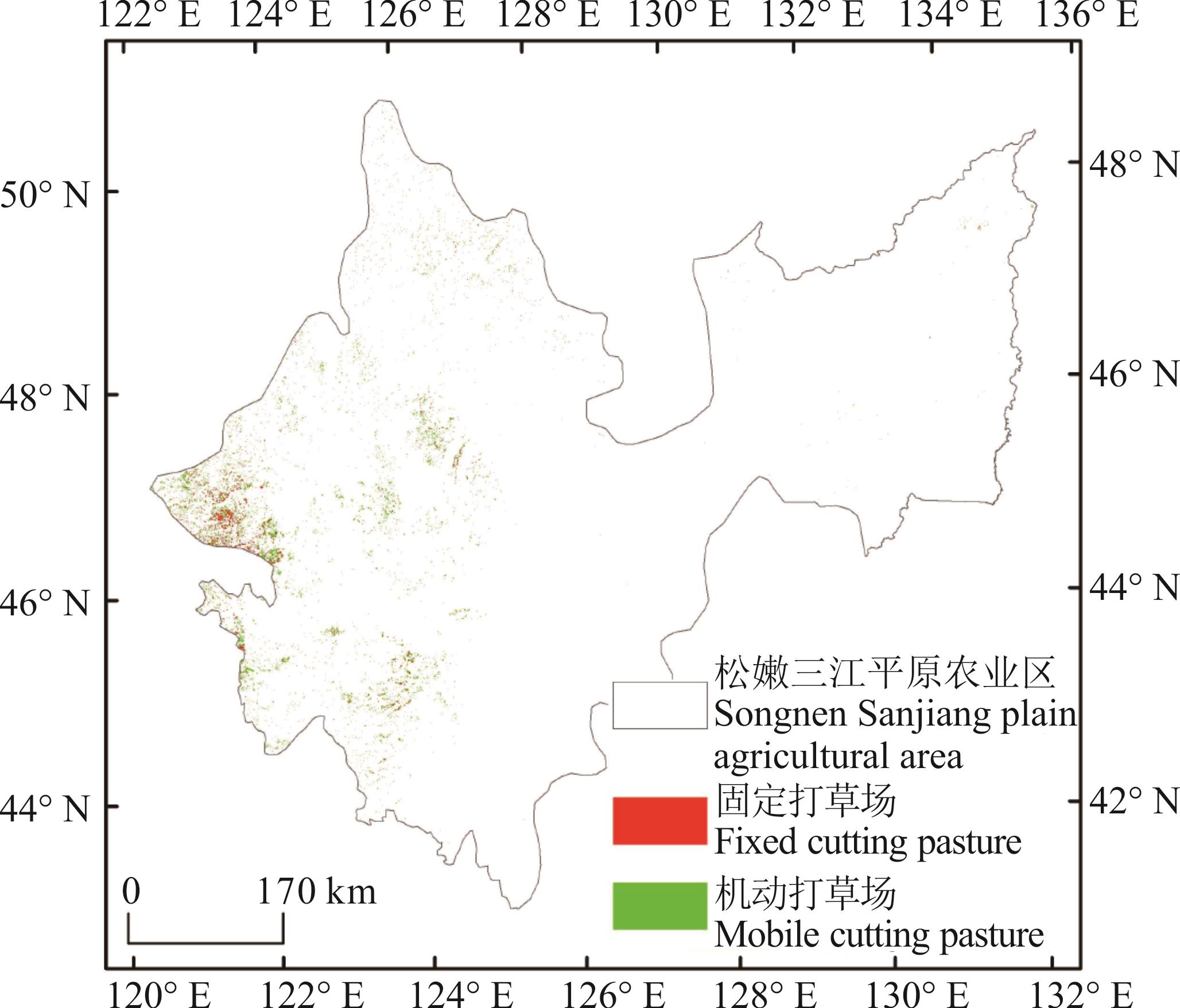
图5 松嫩三江平原农业区的天然打草场分布基于自然资源部标准地图服务网站GS(2024)0650号标准地图制作,底图边界无修改。Produced based on the standard map GS(2024)0650 from the Standard Map Service website of the Ministry of Natural Resources, with no modifications to the base map boundaries.
Fig.5 Distribution of natural cutting pasture in the Songnen Sanjiang plain agricultural area
行政区 Administrative region | 打草场面积 Area of cutting pastures | 固定打草场面积 Area of fixed cutting pastures | 机动打草场面积 Area of mobile cutting pastures | |
|---|---|---|---|---|
| 兴安盟 Xing’an League | 16.92 | 8.20 | 8.72 | |
| 扎赉特旗Jalaid Banner | 13.59 | 6.34 | 7.25 | |
| 科尔沁右翼前旗Horqin Right Front Banner | 2.78 | 1.68 | 1.10 | |
| 白城市 Baicheng City | 5.64 | 1.20 | 4.44 | |
| 洮南市Taonan City | 2.53 | 0.82 | 1.71 | |
| 通榆县Tongyu County | 1.75 | 0.18 | 1.57 | |
| 松原市 Songyuan City | 4.88 | 1.25 | 3.63 | |
| 前郭尔罗斯蒙古族自治县Qian Gorlos Mongol Autonomous County | 3.04 | 0.84 | 2.20 | |
| 齐齐哈尔市 Qiqihar City | 3.61 | 0.56 | 3.05 | |
| 龙江县 Longjiang County | 1.18 | 0.23 | 0.95 | |
| 大庆市 Daqing City | 3.07 | 0.40 | 2.67 | |
| 杜尔伯特蒙古族自治县Dorbod Mongol Autonomous County | 1.38 | 0.17 | 1.21 | |
| 绥化市 Suihua City | 3.01 | 0.90 | 2.11 | |
| 黑河市 Heihe City | 2.11 | 0.49 | 1.62 | |
| 五大连池市Wudalianchi City | 1.02 | 0.27 | 0.75 | |
表7 松嫩三江平原农业区的打草场面积
Table 7 Cutting pasture area in the Songnen Sanjiang plain agricultural area (×104 hm2)
行政区 Administrative region | 打草场面积 Area of cutting pastures | 固定打草场面积 Area of fixed cutting pastures | 机动打草场面积 Area of mobile cutting pastures | |
|---|---|---|---|---|
| 兴安盟 Xing’an League | 16.92 | 8.20 | 8.72 | |
| 扎赉特旗Jalaid Banner | 13.59 | 6.34 | 7.25 | |
| 科尔沁右翼前旗Horqin Right Front Banner | 2.78 | 1.68 | 1.10 | |
| 白城市 Baicheng City | 5.64 | 1.20 | 4.44 | |
| 洮南市Taonan City | 2.53 | 0.82 | 1.71 | |
| 通榆县Tongyu County | 1.75 | 0.18 | 1.57 | |
| 松原市 Songyuan City | 4.88 | 1.25 | 3.63 | |
| 前郭尔罗斯蒙古族自治县Qian Gorlos Mongol Autonomous County | 3.04 | 0.84 | 2.20 | |
| 齐齐哈尔市 Qiqihar City | 3.61 | 0.56 | 3.05 | |
| 龙江县 Longjiang County | 1.18 | 0.23 | 0.95 | |
| 大庆市 Daqing City | 3.07 | 0.40 | 2.67 | |
| 杜尔伯特蒙古族自治县Dorbod Mongol Autonomous County | 1.38 | 0.17 | 1.21 | |
| 绥化市 Suihua City | 3.01 | 0.90 | 2.11 | |
| 黑河市 Heihe City | 2.11 | 0.49 | 1.62 | |
| 五大连池市Wudalianchi City | 1.02 | 0.27 | 0.75 | |
| [1] | Xie G D, Zhang Y L, Lu C X, et al. Study on valuation of rangeland ecosystem services of China. Journal of Natural Resources, 2001, 16(1): 47-53. |
| 谢高地, 张钇锂, 鲁春霞, 等. 中国自然草地生态系统服务价值. 自然资源学报, 2001, 16(1): 47-53. | |
| [2] | Bai Y F, Chen S P. Carbon sequestration of Chinese grassland ecosystems: stock, rate and potential. Chinese Journal of Plant Ecology, 2018, 42(3): 261-264. |
| 白永飞, 陈世苹. 中国草地生态系统固碳现状、速率和潜力研究. 植物生态学报, 2018, 42(3): 261-264. | |
| [3] | Yang Y, Wang G X, Li Y, et al. Spatial-temporal changes in the critical vegetation coverage of grasslands with function of soil-water conversation, wind-breaking and sand-fixing in the Three-Rivers Headwater Region, China. Mountain Research, 2024, 42(2): 143-153. |
| 杨祎, 王根绪, 李阳, 等. 三江源区草地水土保持与防风固沙功能临界植被覆盖度时空变化分析. 山地学报, 2024, 42(2): 143-153. | |
| [4] | Yi M X, Sun Z G, Cong P F, et al. Research progress on the response of grassland ecosystem function to climate change. Chinese Journal of Grassland, 2023, 45(12): 112-120. |
| 羿明璇, 孙政国, 丛鹏飞, 等. 草地生态系统功能对气候变化的响应研究进展. 中国草地学报, 2023, 45(12): 112-120. | |
| [5] | Liu L L, Jing X, Ren H Y, et al. Grassland biodiversity, stability, and implications for grassland conservation and restoration. Bulletin of National Natural Science Foundation of China, 2023, 37(4): 560-570. |
| 刘玲莉, 井新, 任海燕, 等. 草地生物多样性与稳定性及对草地保护与修复的启示. 中国科学基金, 2023, 37(4): 560-570. | |
| [6] | Li X L, Hou X Y, Leonid U, et al. Effects of climate change on household compound ecosystems and herders’ adaptation. Acta Prataculturae Sinica, 2013, 22(1): 148-156. |
| 李西良, 侯向阳, Leonid Ubugunov, 等. 气候变化对家庭牧场复合系统的影响及其牧民适应. 草业学报, 2013, 22(1): 148-156. | |
| [7] | Zhu J, Zhang B, Tan Z L, et al. Research progress of clipping effect on quality and biomass of grazing. Pratacultural Science, 2009, 26(2): 80-85. |
| 朱珏, 张彬, 谭支良, 等. 刈割对牧草生物量和品质影响的研究进展. 草业科学, 2009, 26(2): 80-85. | |
| [8] | Tang H, Gao W, Xu L J, et al. Monitoring forage harvesting area in semi-arid pasture based on Landsat TM images. Transactions of the Chinese Society of Agricultural Engineering, 2015, 31(23): 160-167. |
| 唐欢, 高娃, 徐丽君, 等. 基于Landsat TM影像的半干旱牧区天然打草场面积的遥感监测. 农业工程学报, 2015, 31(23): 160-167. | |
| [9] | He Z X, Zhang M, Wu B F, et al. Extraction of summer crop in Jiangsu based on Google earth engine. Journal of Geo-information Science, 2019, 21(5): 752-766. |
| 何昭欣, 张淼, 吴炳方, 等. Google earth engine支持下的江苏省夏收作物遥感提取. 地球信息科学学报, 2019, 21(5): 752-766. | |
| [10] | Liu T, Ren H R. Object-oriented extraction of paddy rice planting areas using phenological features from the GEE platform. Transactions of the Chinese Society of Agricultural Engineering, 2022, 38(12): 189-196. |
| 刘通, 任鸿瑞. GEE平台下利用物候特征进行面向对象的水稻种植分布提取. 农业工程学报, 2022, 38(12): 189-196. | |
| [11] | Niu Q K, Liu L, Huang G H, et al. Extraction of complex crop structure in the Hetao Irrigation District of Inner Mongolia using GEE and machine learning. Transactions of the Chinese Society of Agricultural Engineering, 2022, 38(6): 165-174. |
| 牛乾坤, 刘浏, 黄冠华, 等. 基于GEE和机器学习的河套灌区复杂种植结构识别. 农业工程学报, 2022, 38(6): 165-174. | |
| [12] | Tang X J, Wei Y Q, Luo D L, et al. Object-oriented tea plantation extraction based on GEE: The case of Shuangjiang County, a typical hilly mountainous area in the subtropical monsoon region of south China. Pratacultural Science, 2024, 41(8): 1897-1908. |
| 唐雪洁, 魏彦强, 罗栋梁, 等. 基于GEE的面向对象茶园提取——以我国南方亚热带季风地区典型丘陵山区双江县为例. 草业科学, 2024, 41(8): 1897-1908. | |
| [13] | Liu J, Wang L M, Yao B M, et al. Ningxia rice area remote sensing estimation on large scale based on multi-temporal OLI data. Transactions of the Chinese Society of Agricultural Engineering, 2017, 33(15): 200-209. |
| 刘佳, 王利民, 姚保民, 等. 基于多时相OLI数据的宁夏大尺度水稻面积遥感估算. 农业工程学报, 2017, 33(15): 200-209. | |
| [14] | Pei H, Sun T J, Wang X Y. Object-oriented land use/cover classification based on texture features of Landsat 8 OLI image. Transactions of the Chinese Society of Agricultural Engineering, 2018, 34(2): 248-255. |
| 裴欢, 孙天娇, 王晓妍. 基于Landsat 8 OLI影像纹理特征的面向对象土地利用/覆盖分类. 农业工程学报, 2018, 34(2): 248-255. | |
| [15] | Vidican R, Mălina A, Ranta O, et al. Using remote sensing vegetation indices for the discrimination and monitoring of agricultural crops: A critical review. Agronomy, 2023, 13(12): 3040. |
| [16] | Jin K, Wang F, Han J Q, et al. Contribution of climatic change and human activities to vegetation NDVI change over China during 1982-2015. Acta Geographica Sinica, 2020, 75(5): 961-974. |
| 金凯, 王飞, 韩剑桥, 等. 1982—2015年中国气候变化和人类活动对植被NDVI变化的影响. 地理学报, 2020, 75(5): 961-974. | |
| [17] | Haralick R M, Shanmugam K, Dinstein I. Textural features for image classification. IEEE Transactions on Systems, Man, and Cybernetics, 1973, 3(6): 610-621. |
| [18] | Hall-beyer M. Practical guidelines for choosing GLCM textures to use in landscape classification tasks over a range of moderate spatial scales. International Journal of Remote Sensing, 2017, 38(5): 1312-1338. |
| [19] | Huang P, Zheng Q, Liang C. Overview of image segmentation methods. Journal of Wuhan University (Natural Science Edition), 2020, 66(6): 519-531. |
| 黄鹏, 郑淇, 梁超. 图像分割方法综述. 武汉大学学报(理学版), 2020, 66(6): 519-531. | |
| [20] | China Land Surveying and Planning Institute, Department of Cadastral Management (Bureau of Real Estate Registration), Ministry of Land and Resources. Current land use classification: GB/T 21010-2017. Beijing: China Standards Press, 2017. |
| 中国土地勘测规划院, 国土资源部地籍管理司(不动产登记局). 土地利用现状分类: GB/T 21010-2017. 北京: 中国标准出版社, 2017. | |
| [21] | Foody G M, Mathur A. A relative evaluation of multiclass image classification by support vector machines. IEEE Transactions on Geoscience and Remote Sensing, 2004, 42(6): 1335-1343. |
| [22] | Huang C, Davis L S, Townshend J R G. An assessment of support vector machines for land cover classification. International Journal of Remote Sensing, 2002, 23(4): 725-749. |
| [23] | Liang Y, Han G D, Zhou H, et al. Study on Inner Mongolia Leymus chinensis steppe in Hexigten Banner grassland utilization. Inner Mongolia Prataculture, 2011, 23(3): 32-36. |
| 梁燕, 韩国栋, 周禾, 等. 内蒙古克什克腾旗羊草草原打草场合理利用的研究. 内蒙古草业, 2011, 23(3): 32-36. | |
| [24] | Chen Y J. Study on the utilization of natural grassland in Inner Mongolia based on meteorological conditions. Beijing: Chinese Academy of Agricultural Sciences, 2007. |
| 陈亚军. 基于气象条件的内蒙古天然打草场利用方式研究. 北京: 中国农业科学院, 2007. | |
| [25] | Suo X J, Xiang L, Gao H, et al. Effects of different utilization methods on community characteristics of primary vegetation of Stipa grandis steppe, Inner Mongolia, China. Acta Prataculturae Sinica, 2024, 33(4): 12-21. |
| 索晓晶, 项磊, 高贺, 等. 不同利用方式对大针茅草原植被群落特征的影响. 草业学报, 2024, 33(4): 12-21. | |
| [26] | Wu J G, Lin L P, Li T W, et al. Fusing Landsat 8 and Sentinel-2 data for 10-m dense time-series imagery using a degradation-term constrained deep network. International Journal of Applied Earth Observation and Geoinformation, 2022, 108: 102738. |
| [27] | Zhao X R, Liu J, Yang S K, et al. Spatio-temporal variations of typical woodland and grassland phenology and its response to meteorological factors in northern China. Acta Ecologica Sinica, 2023, 43(9): 3744-3755. |
| 赵心睿, 刘冀, 杨少康, 等. 北方地区典型林草地物候时空变化特征及其对气象因子的响应. 生态学报, 2023, 43(9): 3744-3755. | |
| [28] | Zhang Q J, Han X L, Liu J. Technology progress and development trend of spaceborne synthetic aperture radar remote sensing. Spacecraft Engineering, 2017, 26(6): 1-8. |
| 张庆君, 韩晓磊, 刘杰. 星载合成孔径雷达遥感技术进展及发展趋势. 航天器工程, 2017, 26(6): 1-8. | |
| [29] | Breiman L. Random forests. Machine Learning, 2001, 45(1): 5-32. |
| [30] | Chen T Q, Guestrin C. XGBoost: A scalable tree boosting system//Proceedings of the 22nd ACM SIGKDD International Conference on Knowledge Discovery and Data Mining. San Francisco: ACM, 2016: 785-794. |
| [31] | Li M, Ning D J, Guo J C. Attention mechanism-based CNN-LSTM model and its application. Computer Engineering and Applications, 2019, 55(13): 20-27. |
| 李梅, 宁德军, 郭佳程. 基于注意力机制的CNN-LSTM模型及其应用. 计算机工程与应用, 2019, 55(13): 20-27. |
| No related articles found! |
| 阅读次数 | ||||||
|
全文 |
|
|||||
|
摘要 |
|
|||||