

ISSN 1004-5759 CN 62-1105/S
草业学报 ›› 2022, Vol. 31 ›› Issue (8): 1-12.DOI: 10.11686/cyxb2021319
• 研究论文 •
王莺1( ), 王健顺2, 张强1
收稿日期:2021-08-25
修回日期:2021-10-21
出版日期:2022-08-20
发布日期:2022-07-01
作者简介:王莺(1984-),女,甘肃兰州人,副研究员,博士。E-mail: wangyn924@163.com
基金资助:
Ying WANG1(), Jian-shun WANG2, Qiang ZHANG1
Received:2021-08-25
Revised:2021-10-21
Online:2022-08-20
Published:2022-07-01
摘要:
干旱灾害是制约中国草原生产力的首要自然灾害。通过分析草原干旱风险的形成原因,收集气象、土壤、植被、地形地貌等数据,从干旱灾害的致灾因子危险性、承灾体暴露性和敏感性以及孕灾环境脆弱性入手,建立了草原干旱风险评价指标体系。采用熵权法确定各指标权重,构建了干旱风险评价模型。基于地理信息系统(GIS)空间分析功能,对中国草原进行了干旱风险评估与区划。结果表明,中国草原的较高危险区主要位于内蒙古地区、河西走廊、柴达木和塔里木盆地边缘、青藏高原西部以及云南地区。较高暴露区主要位于中国的西南和华南地区。较高敏感区主要位于内蒙古东南部、东北地区、青藏高原南部和东部边坡、塔里木盆地北边缘以及西南地区。较高脆弱区主要分布在内蒙古中部和东部、甘肃河西走廊、新疆北部、青藏高原大部分地区、云南和川东地区。较高干旱风险区主要位于内蒙古东北部、东北西部、宁夏北部、塔里木盆地北边缘、青藏高原南部、云贵高原、河南和山东地区。研究结果可为中国草原的科学抗旱提供基础数据与理论支撑。
王莺, 王健顺, 张强. 中国草原干旱灾害风险特征研究[J]. 草业学报, 2022, 31(8): 1-12.
Ying WANG, Jian-shun WANG, Qiang ZHANG. Drought risk status of grassland in China[J]. Acta Prataculturae Sinica, 2022, 31(8): 1-12.
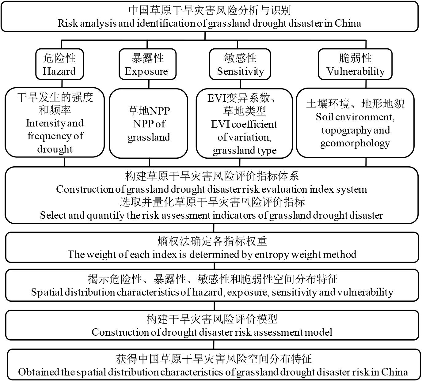
图1 中国草原干旱灾害风险评价技术路线
Fig.1 Technical route of grassland drought disaster risk assessment in China
| 等级Grade | 类型Type | SPEI |
|---|---|---|
| 1 | 轻旱Light drought | -1.0<SPEI≤-0.5 |
| 2 | 中旱Moderate drought | -1.5<SPEI≤-1.0 |
| 3 | 重旱Severe drought | -2.0<SPEI≤-1.5 |
| 4 | 特旱Extreme drought | SPEI≤-2.0 |
表1 标准化降水蒸散指数旱涝等级划分
Table 1 Classification standard of drought based on SPEI
| 等级Grade | 类型Type | SPEI |
|---|---|---|
| 1 | 轻旱Light drought | -1.0<SPEI≤-0.5 |
| 2 | 中旱Moderate drought | -1.5<SPEI≤-1.0 |
| 3 | 重旱Severe drought | -2.0<SPEI≤-1.5 |
| 4 | 特旱Extreme drought | SPEI≤-2.0 |
| 草原类型Grassland type | 赋值Assignment | 草原类型Grassland type | 赋值Assignment |
|---|---|---|---|
| 温性草甸草原 Temperate meadow grassland | 6.5 | 暖性灌草丛类 Warm shrub grass | 4.8 |
| 高寒草甸草原 Alpine meadow grassland | 6.0 | 热性灌草丛类 Thermal shrub grass | 4.5 |
| 温性草原 Temperate grassland | 7.5 | 干热稀树灌草丛类 Dry hot sparse shrub grass | 7.2 |
| 高寒草原 Alpine grassland | 7.0 | 低地草甸 Lowland meadow | 5.0 |
| 温性荒漠化草原 Temperate desertification grassland | 8.5 | 山地草甸 Mountain meadow | 5.3 |
| 高寒荒漠化草原 Alpine desertification grassland | 8.0 | 高寒草甸 Alpine meadow | 5.6 |
| 温性草原化荒漠 Temperate grassland desertification | 9.0 | 温性荒漠 Temperate desert | 10.0 |
| 暖性草丛类 Warm grass | 3.5 | 高寒荒漠 Alpine desert | 10.0 |
| 热性草丛类 Thermal grass | 3.0 | 沼泽 Swamp | 2.0 |
| 改良草地 Improved grassland | 1.0 |
表2 不同草原类型的干旱敏感性
Table 2 Drought sensitivity of different grassland types
| 草原类型Grassland type | 赋值Assignment | 草原类型Grassland type | 赋值Assignment |
|---|---|---|---|
| 温性草甸草原 Temperate meadow grassland | 6.5 | 暖性灌草丛类 Warm shrub grass | 4.8 |
| 高寒草甸草原 Alpine meadow grassland | 6.0 | 热性灌草丛类 Thermal shrub grass | 4.5 |
| 温性草原 Temperate grassland | 7.5 | 干热稀树灌草丛类 Dry hot sparse shrub grass | 7.2 |
| 高寒草原 Alpine grassland | 7.0 | 低地草甸 Lowland meadow | 5.0 |
| 温性荒漠化草原 Temperate desertification grassland | 8.5 | 山地草甸 Mountain meadow | 5.3 |
| 高寒荒漠化草原 Alpine desertification grassland | 8.0 | 高寒草甸 Alpine meadow | 5.6 |
| 温性草原化荒漠 Temperate grassland desertification | 9.0 | 温性荒漠 Temperate desert | 10.0 |
| 暖性草丛类 Warm grass | 3.5 | 高寒荒漠 Alpine desert | 10.0 |
| 热性草丛类 Thermal grass | 3.0 | 沼泽 Swamp | 2.0 |
| 改良草地 Improved grassland | 1.0 |
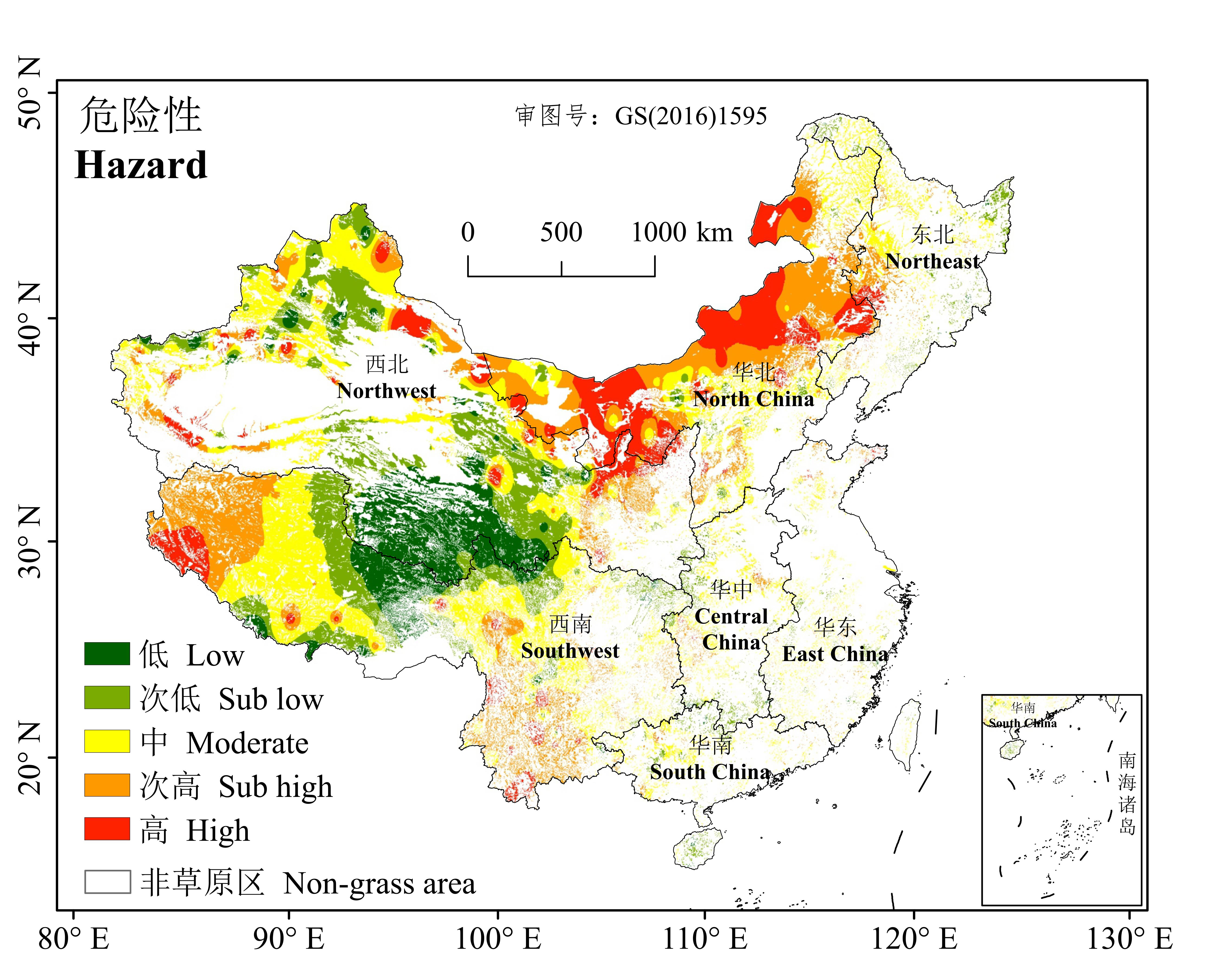
图2 草原干旱的危险性空间分布
Fig.2 The distribution of the drought hazard for grassland
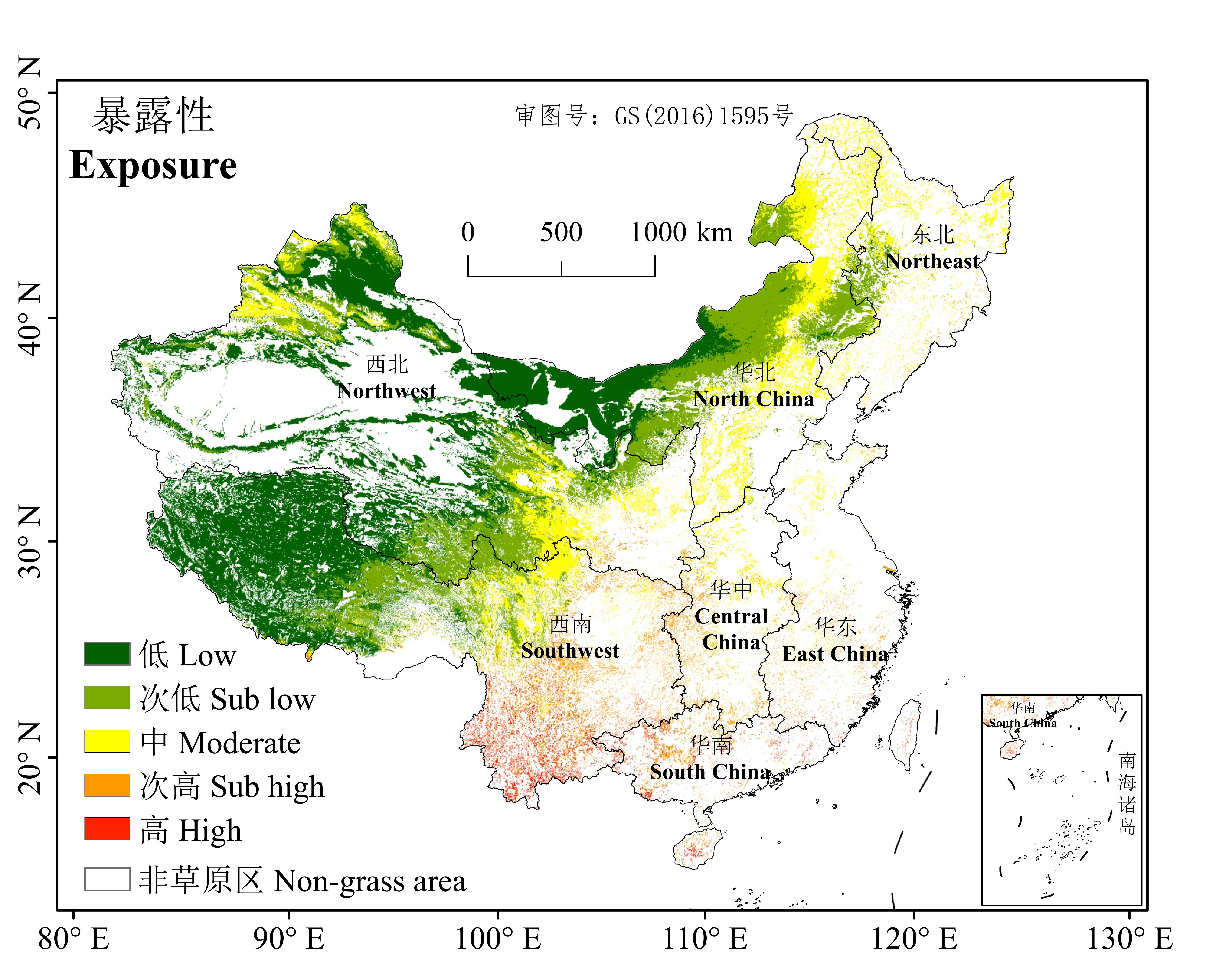
图3 承灾体暴露性空间分布
Fig.3 The distribution of the drought exposure for grassland

图4 承灾体敏感性指标及空间分布
Fig. 4 Sensitivity indices for grass and their spatial distribution

图5 孕灾环境脆弱性指标及空间分布
Fig. 5 Vulnerability indices for grass and their spatial distribution
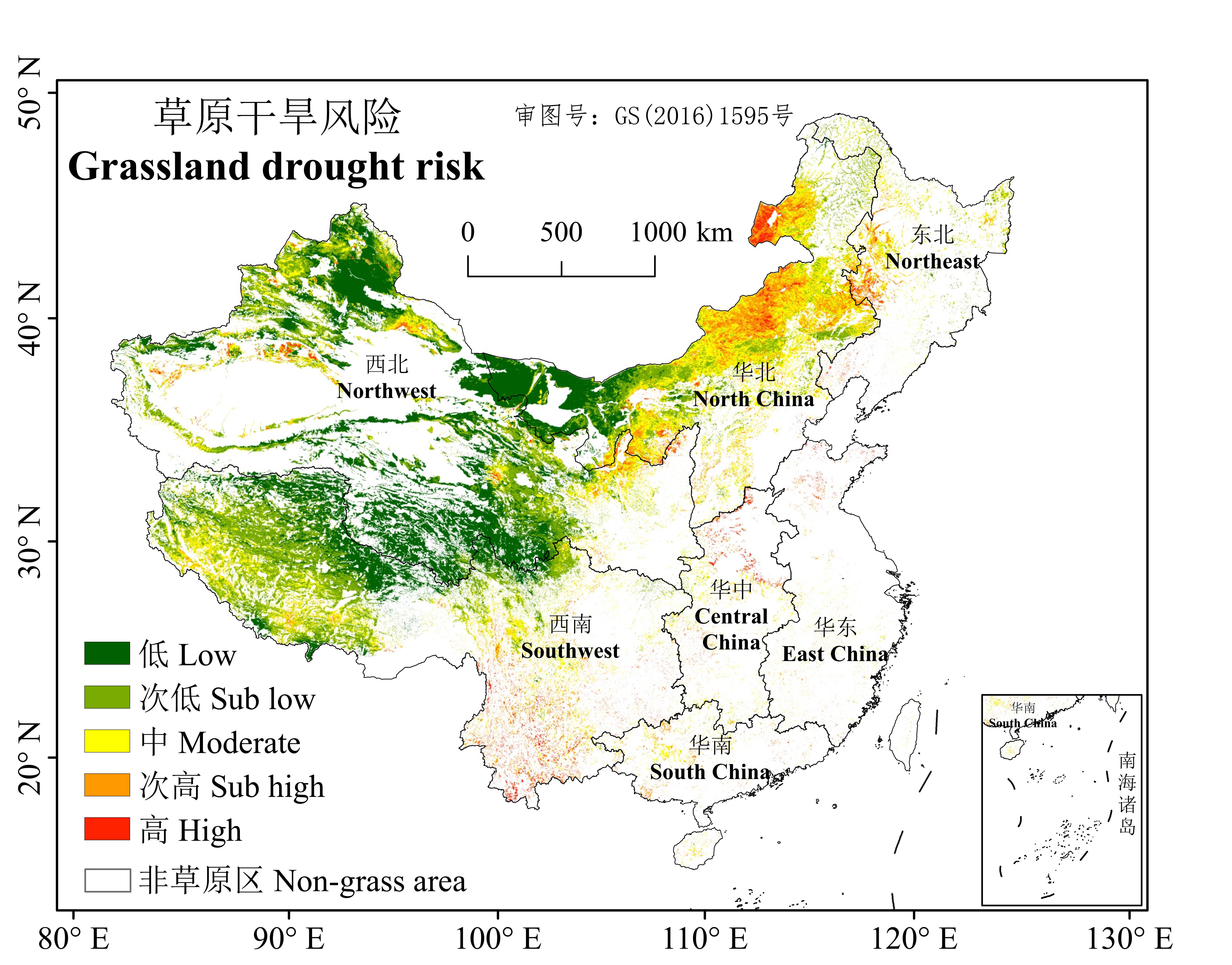
图6 中国草原干旱风险空间分布
Fig.6 Spatial distribution of grassland drought risk in China
| 1 | Shen H H, Zhu Y K, Zhao X, et al. Analysis of current grassland resources in China.Chinese Science Bulletin, 2016, 61(2): 139-154. |
| 沈海花, 朱言坤, 赵霞, 等. 中国草地资源的现状分析. 科学通报, 2016, 61(2): 139-154. | |
| 2 | Li L, Hou F J. The main natural disasters affecting grassland productivity in China. Pratacultural Science, 2016, 33(5): 981-989. |
| 李岚, 侯扶江. 我国草原生产的主要自然灾害. 草业科学, 2016, 33(5): 981-989. | |
| 3 | Su B, Huang J, Fischer T, et al. Drought losses in China might double between the 1.5 ℃ and 2.0 ℃ warming. Proceedings of the National Academy of Sciences, 2018, 115(42): 10600-10605. |
| 4 | Zhao Y Q, Xiao D P, Bai H Z. Projection and application for future climate in China by CMIPS climate model. Meteorological Science & Technology, 2019, 47(4): 608-621. |
| 赵彦茜, 肖登攀, 柏会子. CMIP5气候模式对中国未来气候变化的预估和应用. 气象科技, 2019, 47(4): 608-621. | |
| 5 | Zhang G X, Su X L, Liu W F. Future drought trend in China considering CO2 concentration. Transactions of the Chinese Society of Agricultural Engineering, 2021, 37(1): 84-91. |
| 张更喜, 粟晓玲, 刘文斐. 考虑CO2浓度影响的中国未来干旱趋势变化. 农业工程学报, 2021, 37(1): 84-91. | |
| 6 | Wilhite D A. Introduction: Managing drought risk in a changing climate. Climate Research, 2016, 70(2): 99-102. |
| 7 | IPCC. Climate change 2013: The physical science basis//Contribution of working group I to the fifth assessment report of the intergovernmental panel on climate change. Cambridge, United Kingdom and New York, NY, USA: Cambridge University Press, 2013. |
| 8 | Zhang J Q, Liu X M, Yan D H. Introduction to integrated disaster risk management. Beijing: Peking University Press, 2012. |
| 张继权, 刘兴明, 严登华. 综合灾害风险管理导论. 北京: 北京大学出版社, 2012. | |
| 9 | Zhang Q, Tang H P, Cui F Q, et al. SPEI-based analysis of drought characteristics and trends in Hulun Buir grassland. Acta Ecologica Sinica, 2019, 39(19): 7110-7123. |
| 张钦, 唐海萍, 崔凤琪, 等. 基于SPEI的呼伦贝尔草原干旱变化特征及趋势分析. 生态学报, 2019, 39(19): 7110-7123. | |
| 10 | Ding Y, Xu J, Wang X, et al. Spatial and temporal effects of drought on Chinese vegetation under different coverage levels. Science of the Total Environment, 2020, 716(6247): 137166. |
| 11 | Qin Y, Zhang T B, Yi G H, et al. Remote sensing monitoring and analysis of influencing factors of drought in Inner Mongolia growing season since 2000. Journal of Natural Resources, 2021, 36(2): 459-475. |
| 覃艺, 张廷斌, 易桂花, 等. 2000年以来内蒙古生长季旱情变化遥感监测及其影响因素分析. 自然资源学报, 2021, 36(2): 459-475. | |
| 12 | Zhang Q F, Liu G X, Yu H B, et al. Soil moisture modeling and drought monitoring using remote sensing in Xilingol grassland. Acta Prataculturae Sinica, 2017, 26(11): 1-11. |
| 张巧凤, 刘桂香, 于红博, 等. 锡林郭勒草原土壤含水量遥感反演模型及干旱监测. 草业学报, 2017, 26(11): 1-11. | |
| 13 | Jia Y T, Cui X Y, Liu Y X, et al. Drought vulnerability assessment in Inner Mongolia. Acta Ecologica Sinica, 2020, 40(24): 9070-9082. |
| 贾元童, 崔骁勇, 刘月仙, 等. 内蒙古自治区干旱脆弱性评价. 生态学报, 2020, 40(24): 9070-9082. | |
| 14 | Zhou L G, Du F L, Zhang X F, et al. The vulnerability assessment of grassland livestock industry to drought: A case study in pasture of Xilingol, Inner Mongolia. Chinese Journal of Ecology, 2014, 33(1): 259-268. |
| 周利光, 杜凤莲, 张雪峰, 等. 草原畜牧业对干旱的脆弱性评估——以内蒙古锡林郭勒草原为例. 生态学杂志, 2014, 33(1): 259-268. | |
| 15 | Li W L, Cai D, Su W L, et al. Dynamic assessment of ecological risk owing to drought in alpine meadows based on SPEI index and GIS technology. Pratacultural Science, 2019, 36(6): 1531-1543. |
| 李文龙, 蔡栋, 苏文亮, 等. 基于SPEI指数与GIS技术的高寒草地干旱生态风险动态评价. 草业科学, 2019, 36(6): 1531-1543. | |
| 16 | Zhang C H, Zhang L, Wu Y J, et al. Assessment on the integrated drought disaster risk in Inner Mongolia grassland. Journal of Arid Land Resources and Environment, 2019, 33(7): 115-121. |
| 张存厚, 张立, 吴英杰, 等. 内蒙古草原干旱灾害综合风险评估. 干旱区资源与环境, 2019, 33(7): 115-121. | |
| 17 | Ren Z H, Zhang Z F, Sun C, et al. Development of three-step quality control system of real-time observation data from AWS in China. Meteorological Monthly, 2015, 41(10): 1268-1277. |
| 任芝花, 张志富, 孙超, 等. 全国自动气象站实时观测资料三级质量控制系统研制. 气象, 2015, 41(10): 1268-1277. | |
| 18 | Li D K, Wang Z. The characteristics of NPP of terrestrial vegetation in China based on MODIS17A3 data. Ecology and Environmental Sciences, 2018, 27(3): 397-405. |
| 李登科, 王钊. 基于MODIS17A3的中国陆地植被NPP变化特征分析. 生态环境学报, 2018, 27(3): 397-405. | |
| 19 | Sun D X. The compilation and study of the grassland resource map of China on the scale of 1∶1000000. Journal of Natural Resources, 1996, 11(1): 75-83. |
| 苏大学. 1∶1000000中国草地资源图的编制与研究. 自然资源学报, 1996, 11(1): 75-83. | |
| 20 | Vicente-Serrano S M, Beguería S, López-Moreno J I. A multiscalar drought index sensitive to global warming: The standardized precipitation evapotranspiration index. Journal of Climate, 2010, 23(7): 1696-1718. |
| 21 | Vicente-Serrano S M, Beguería S, Lorenzo-Lacruz J, et al. Performance of drought indices for ecological, agricultural and hydrological applications.Earth Interactions, 2012, 16: 10. |
| 22 | Vicente-Serrano S M, Gouveia C, Camarero J J, et al. Response of vegetation to drought time-scales across global land biomes. Proceedings of the National Academy of Sciences, 2013, 110(1): 52-57. |
| 23 | Beguería S, Vicente-Serrano S M, Reig F, et al. Standardized precipitation evapotranspiration index (SPEI) revisited: Parameter fitting, evapotranspiration models, tools, datasets and drought monitoring. International Journal of Climatology, 2013, 34(10): 3001-3023. |
| 24 | Spinoni J, Barbosa P, Bucchignani E, et al. Future global meteorological drought hot spots: A study based on CORDEX data. Journal of Climate, 2020, 33(9): 3635-3661. |
| 25 | General Administration of Quality Supervision, Inspection and Quarantine of the People’s Republic of China, National Standardization Administration of China. Grades of meteorological drought, GB/T 20481-2017. Beijing: China Standards Press, 2017. |
| 中华人民共和国国家质量监督检验检疫总局,中国国家标准化管理委员会. 气象干旱等级, GB/T 20481-2017. 北京: 中国标准出版社, 2017. | |
| 26 | Huang C F. Risk analysis and management of natural disaster. Beijing: Science Press, 2012. |
| 黄崇福. 自然灾害风险分析与管理. 北京: 科学出版社, 2012. | |
| 27 | Huang C F, Zhang J X, Liu J. Applications of fuzzy information optimization technology. Information and Control, 2004, 33(1): 61-66. |
| 黄崇福, 张俊香, 刘静. 模糊信息化处理技术应用简介. 信息与控制, 2004, 33(1): 61-66. | |
| 28 | Liu Y Y, Zhang Z Y, Tong L J, et al. Spatiotemporal dynamics of China’s grassland NPP and its driving factors. Chinese Journal of Ecology, 2020, 39(2): 349-363. |
| 刘洋洋, 章钊颖, 同琳静, 等. 中国草地净初级生产力时空格局及其影响因素. 生态学杂志, 2020, 39(2): 349-363. | |
| 29 | Hou F J, Wang C M, Lou S N, et al. Rangeland productivity in China. Strategic Study of CAE, 2016, 18(1): 80-93. |
| 侯扶江, 王春梅, 娄珊宁, 等. 我国草原生产力. 中国工程科学, 2016, 18(1): 80-93. | |
| 30 | Yao X C, Qu T T, Chang W J, et al. Estimation of grassland biomass using MODIS data and plant community characteristics. Chinese Journal of Eco-Agriculture, 2017, 25(4): 530-541. |
| 姚兴成, 曲恬甜, 常文静, 等. 基于MODIS数据和植被特征估算草地生物量. 中国生态农业学报, 2017, 25(4): 530-541. | |
| 31 | Zhao H F, Li X D, Zhang D, et al. Aboveground biomass in grasslands in Qinghai Province estimated from MODIS data and its influencing factors. Acta Prataculturae Sinica, 2020, 29(12): 5-16. |
| 赵慧芳, 李晓东, 张东, 等. 基于MODIS数据的青海省草地地上生物量估算及影响因素研究. 草业学报, 2020, 29(12): 5-16. | |
| 32 | Wang Z X, Liu C, Huete A. From AVHRR-NDVI to MODIS-EVI: Advances in vegetation index research. Acta Ecologica Sinica, 2003, 23(5): 979-987. |
| 王正兴, 刘闯, Huete A. 植被指数研究进展: 从AVHRR-NDVI到MODIS-EVI. 生态学报, 2003, 23(5): 979-987. | |
| 33 | Lai Q, Li Q F, Morigen A, et al. Study on determination of water content and estimation method of dry fresh ratio for herbage. Inner Mongolia Prataculture, 2008, 20(3): 4-7. |
| 来强, 李青丰, 莫日根敖其尔, 等. 草地牧草含水量测定暨干鲜比估测方法研究. 内蒙古草业, 2008, 20(3): 4-7. | |
| 34 | Wu W Z. Spatial heterogeneity of soil moisture and its relation to topographic factors at hillslope scale. Lanzhou: Lanzhou University, 2014. |
| 吴维臻. 坡面尺度土壤水分空间异质性特征及其与地形因子的关系. 兰州: 兰州大学, 2014. | |
| 35 | Liu J H, Li M L, Su J B, et al. Effects of soil organic matter content and terrain slope on soil moisture, crop yield. Hunan Agricultural Sciences, 2017(1): 16-18. |
| 刘建华, 李铭亮, 苏剑波, 等. 有机质含量、地形坡度对土壤保水效果及作物产量的影响. 湖南农业科学, 2017(1): 16-18. | |
| 36 | Yan L, Zhang J Q, Wang C Y, et al. Vulnerability evaluation and regionalization of drought disaster risk of maize in Northwestern Liaoning Province. Chinese Journal of Eco-Agriculture, 2012, 20(6): 788-794. |
| 阎莉, 张继权, 王春乙, 等. 辽西北玉米干旱脆弱性评价模型构建与区划研究. 中国生态农业学报, 2012, 20(6): 788-794. | |
| 37 | Li N Q, Xu G Y. Grid analysis of land use based on natural breaks (jenks) classification. Bulletin of Surveying and Mapping, 2020(4): 106-110. |
| 李乃强, 徐贵阳. 基于自然间断点分级法的土地利用数据网格化分析. 测绘通报, 2020(4): 106-110. | |
| 38 | Wang J. The impact of extreme drought on ecosystem services and values of temperate grassland in Inner Mongolia. Beijing: Chinese Academy of Agricultural Sciences, 2021. |
| 王杰. 极端干旱对内蒙古温带草原生态系统服务功能和价值的影响. 北京: 中国农业科学院, 2021. | |
| 39 | Chen X T, Deng C. Spatiotemporal characteristics of water use efficiency and its relationship with climatic factors of grassland ecosystems in China from 2000 to 2015. China Rural Water and Hydropower, 2021, 5: 55-60, 67. |
| 陈鑫涛, 邓超. 2000-2015年中国草地生态系统水分利用效率时空特征及其对气候要素的响应. 中国农村水利水电, 2021, 5: 55-60, 67. |
| [1] | 李宇宇, 贾玉山, 格根图, 王志军, 都帅, 孙林, 降晓伟, 吴洪新, 侯美玲, 陈喜梅. 饲用草产品主要真菌毒素污染检测、风险评估与控制研究进展[J]. 草业学报, 2021, 30(4): 191-204. |
| [2] | 王莺, 沙莎, 王素萍, 王劲松, 姚玉璧. 中国南方干旱灾害风险评估[J]. 草业学报, 2015, 24(5): 12-24. |
| [3] | 黄训兵, 吴惠惠, 秦兴虎, 曹广春, 王广君, 农向群, 涂雄兵, 格希格都仁, 贺兵, 额尔登巴图, 乌亚汗, 张泽华. 基于投影寻踪模型的草原蝗虫栖境评价及风险评估[J]. 草业学报, 2015, 24(5): 25-33. |
| [4] | 刘春英,孙学映,朱体超,陈光蓉,郑章云. 不同黑麦草品种生产性能比较与优势品种筛选[J]. 草业学报, 2014, 23(4): 39-48. |
| [5] | 高雅,林慧龙. 草地生态系统服务价值估算前瞻[J]. 草业学报, 2014, 23(3): 290-301. |
| [6] | 姜红霞,杨成德,蒲崇建,陈秀蓉,尚勋武. 马铃薯坏疽病菌在中国的适生区预测及其风险性评估[J]. 草业学报, 2014, 23(3): 276-281. |
| [7] | 王世金,魏彦强,方苗. 青海省三江源牧区雪灾综合风险评估[J]. 草业学报, 2014, 23(2): 108-116. |
| [8] | 刘兴元,牟月亭. 草地生态系统服务功能及其价值评估研究进展[J]. 草业学报, 2012, 21(6): 286-295. |
| [9] | 刘兴元, 龙瑞军, 尚占环. 草地生态系统服务功能及其价值评估方法研究[J]. 草业学报, 2011, 20(1): 167-174. |
| 阅读次数 | ||||||
|
全文 |
|
|||||
|
摘要 |
|
|||||