
ISSN 1004-5759 CN 62-1105/S
Acta Prataculturae Sinica ›› 2022, Vol. 31 ›› Issue (4): 165-176.DOI: 10.11686/cyxb2021057
Rui HUA1( ), Rui ZHOU1,2, Daerhan BAO1, Ke-chi DONG1, Zhuang-sheng TANG1, Li-min HUA1()
Received:2021-02-08
Revised:2021-04-01
Online:2022-04-20
Published:2022-01-25
Contact:
Li-min HUA
Rui HUA, Rui ZHOU, Daerhan BAO, Ke-chi DONG, Zhuang-sheng TANG, Li-min HUA. A study of UAV remote sensing technology for classifying the level of plateau pika damage to alpine rangeland[J]. Acta Prataculturae Sinica, 2022, 31(4): 165-176.
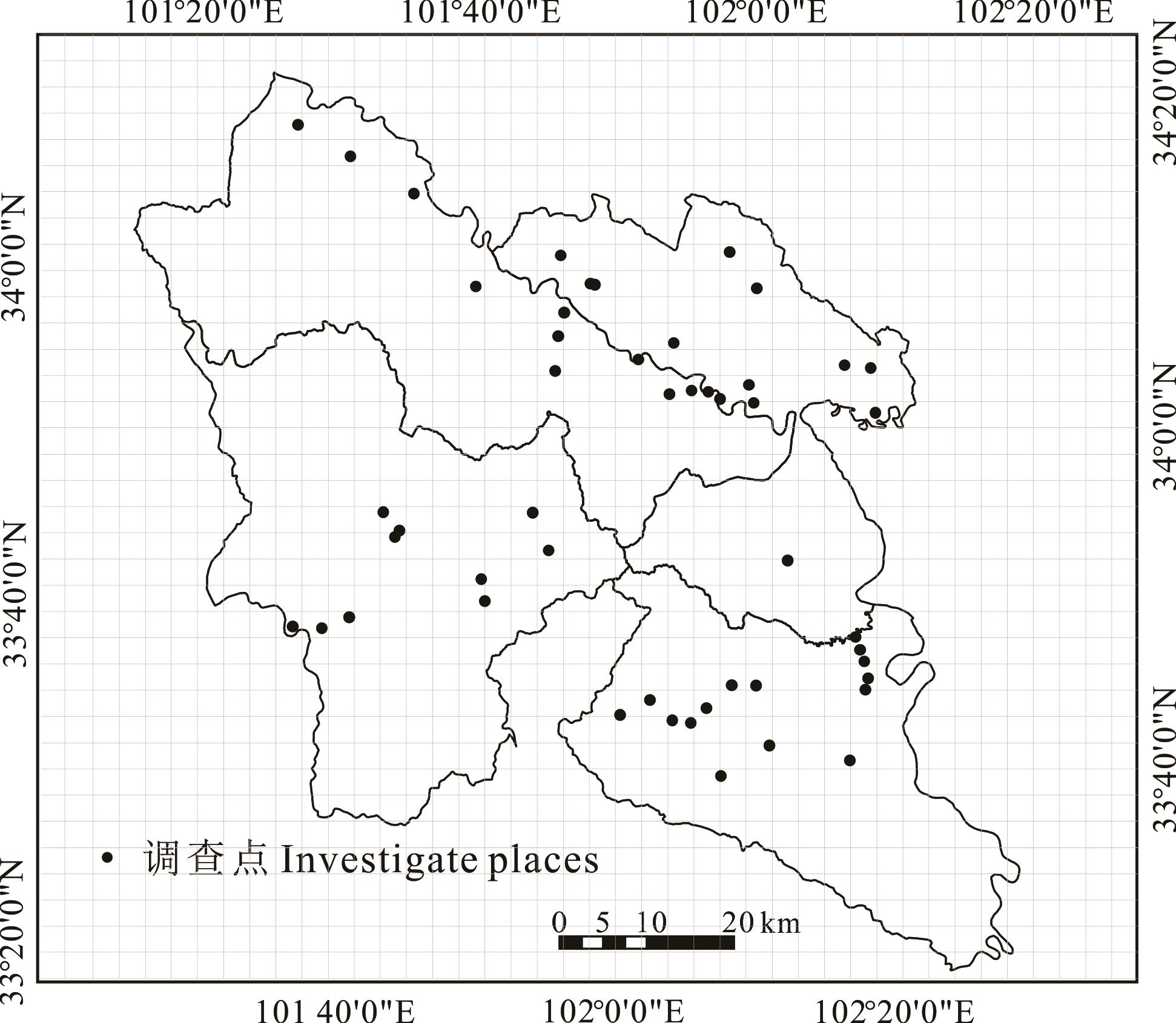
Fig.1 Sampling sites of plateau pika in Maqu county

Fig.2 Results of each vegetation index
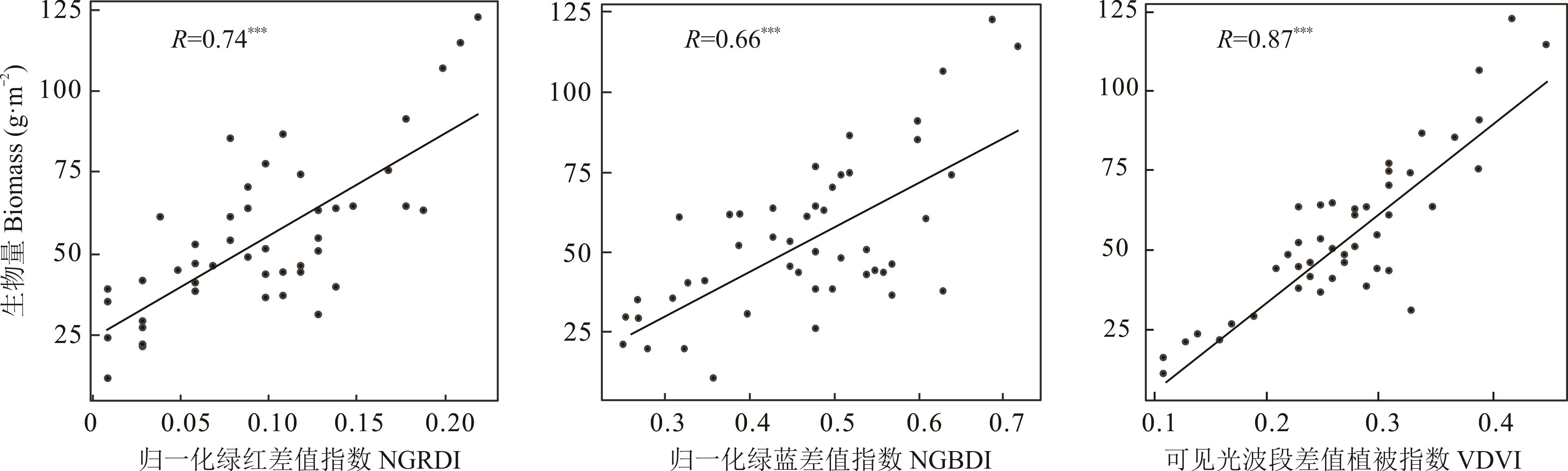
Fig.3 Correlation between biomass and vegetation index
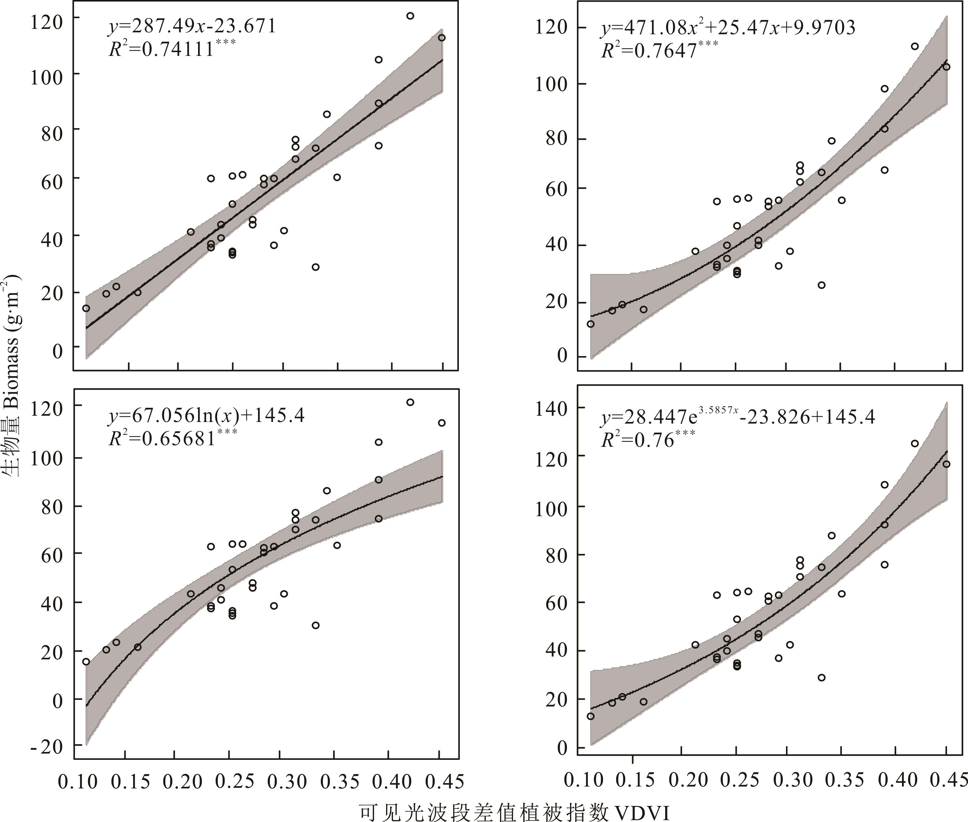
Fig.4 Correlation between biomass and VDVI
样方号 Quadrat number | 经度 Longitude | 纬度 Latitude | 实测值 Measuring value | 预测值 Estimating value | 绝对误差 Absolute error | 估产精度 Yield estimation accuracy (%) |
|---|---|---|---|---|---|---|
| 1 | 101.0011 | 34.0189 | 45.24 | 51.1889 | 5.9489 | 86.85 |
| 2 | 102.0014 | 33.1353 | 47.49 | 38.3740 | 9.1160 | 80.80 |
| 3 | 101.0850 | 33.1511 | 60.44 | 63.1368 | 2.6968 | 95.53 |
| 4 | 101.1339 | 33.1186 | 50.27 | 54.0346 | 3.7646 | 92.51 |
| 5 | 102.0672 | 33.1344 | 84.36 | 83.8851 | 0.4749 | 99.43 |
| 6 | 101.0525 | 33.0014 | 44.06 | 40.7485 | 3.3115 | 92.48 |
| 7 | 101.1017 | 33.0011 | 25.91 | 27.9144 | 2.0044 | 92.26 |
| 8 | 101.1186 | 33.0186 | 51.72 | 40.7485 | 10.9715 | 78.78 |
| 9 | 101.0000 | 33.1011 | 40.21 | 48.4375 | 8.2275 | 79.53 |
| 10 | 101.0019 | 33.1172 | 28.44 | 31.8156 | 3.3756 | 88.13 |
| 11 | 101.1167 | 33.0503 | 49.62 | 48.4375 | 1.1825 | 97.61 |
| 12 | 101.1167 | 33.0839 | 53.94 | 60.0085 | 6.0685 | 88.74 |
| 13 | 101.0669 | 33.0006 | 42.76 | 63.1368 | 20.3768 | 52.34 |
Table 1 The absolute error and yield estimation accuracy between simulate data and measuring data
样方号 Quadrat number | 经度 Longitude | 纬度 Latitude | 实测值 Measuring value | 预测值 Estimating value | 绝对误差 Absolute error | 估产精度 Yield estimation accuracy (%) |
|---|---|---|---|---|---|---|
| 1 | 101.0011 | 34.0189 | 45.24 | 51.1889 | 5.9489 | 86.85 |
| 2 | 102.0014 | 33.1353 | 47.49 | 38.3740 | 9.1160 | 80.80 |
| 3 | 101.0850 | 33.1511 | 60.44 | 63.1368 | 2.6968 | 95.53 |
| 4 | 101.1339 | 33.1186 | 50.27 | 54.0346 | 3.7646 | 92.51 |
| 5 | 102.0672 | 33.1344 | 84.36 | 83.8851 | 0.4749 | 99.43 |
| 6 | 101.0525 | 33.0014 | 44.06 | 40.7485 | 3.3115 | 92.48 |
| 7 | 101.1017 | 33.0011 | 25.91 | 27.9144 | 2.0044 | 92.26 |
| 8 | 101.1186 | 33.0186 | 51.72 | 40.7485 | 10.9715 | 78.78 |
| 9 | 101.0000 | 33.1011 | 40.21 | 48.4375 | 8.2275 | 79.53 |
| 10 | 101.0019 | 33.1172 | 28.44 | 31.8156 | 3.3756 | 88.13 |
| 11 | 101.1167 | 33.0503 | 49.62 | 48.4375 | 1.1825 | 97.61 |
| 12 | 101.1167 | 33.0839 | 53.94 | 60.0085 | 6.0685 | 88.74 |
| 13 | 101.0669 | 33.0006 | 42.76 | 63.1368 | 20.3768 | 52.34 |
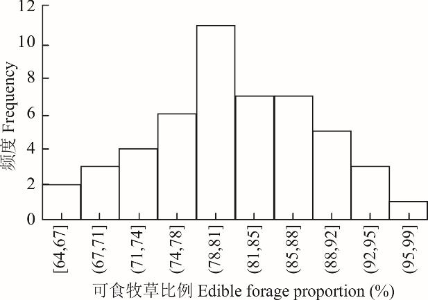
Fig.5 Frequency of edible forage proportion

Fig.6 Correlation analysis between image interpretation results and measured values
成分 Components | 初始特征根值 Initial eigenvalue | 方差贡献率 Contribution rate of variance (%) | 累积方差贡献率 Cumulative variance contribution rate (%) |
|---|---|---|---|
| 1 | 1.868 | 46.698 | 46.698 |
| 2 | 0.945 | 23.617 | 70.315 |
| 3 | 0.764 | 19.112 | 89.427 |
| 4 | 0.432 | 10.573 | 100 |
Table 2 The principal component eigenvalue and variance contribution rate
成分 Components | 初始特征根值 Initial eigenvalue | 方差贡献率 Contribution rate of variance (%) | 累积方差贡献率 Cumulative variance contribution rate (%) |
|---|---|---|---|
| 1 | 1.868 | 46.698 | 46.698 |
| 2 | 0.945 | 23.617 | 70.315 |
| 3 | 0.764 | 19.112 | 89.427 |
| 4 | 0.432 | 10.573 | 100 |
指标 Indicator | 载荷数Load number | 系数 Coefficient | ||
|---|---|---|---|---|
第1主成分 The first principal component | 第2主成分 The second principal component | 第1主成分 The first principal component | 第2主成分 The second principal component | |
| 鼠洞个数Pikas’ hole amount | -0.588 | 0.408 | -0.266 | 0.665 |
| 可见光波段植被指数VDVI | 0.796 | 0.380 | 0.873 | -0.121 |
| 解译盖度Interpretation coverage | 0.809 | 0.351 | 0.869 | -0.153 |
| 牧草比例Proportion of edible forage | -0.483 | 0.715 | -0.010 | 0.863 |
Table 3 Load number and coefficient of each indicator
指标 Indicator | 载荷数Load number | 系数 Coefficient | ||
|---|---|---|---|---|
第1主成分 The first principal component | 第2主成分 The second principal component | 第1主成分 The first principal component | 第2主成分 The second principal component | |
| 鼠洞个数Pikas’ hole amount | -0.588 | 0.408 | -0.266 | 0.665 |
| 可见光波段植被指数VDVI | 0.796 | 0.380 | 0.873 | -0.121 |
| 解译盖度Interpretation coverage | 0.809 | 0.351 | 0.869 | -0.153 |
| 牧草比例Proportion of edible forage | -0.483 | 0.715 | -0.010 | 0.863 |
指标 Indicator | 贡献率Contribution rate (%) | 权重Weight |
|---|---|---|
| 鼠洞个数Pikas’ hole amount | 4.67 | 0.0485 |
| 可见光波段植被指数 VDVI | 53.91 | 0.5599 |
| 解译盖度Interpretation coverage | 52.57 | 0.5460 |
| 可食牧草比例Proportion of edible forage | 28.32 | 0.2941 |
Table 4 Contribution rate and weight of each indicator
指标 Indicator | 贡献率Contribution rate (%) | 权重Weight |
|---|---|---|
| 鼠洞个数Pikas’ hole amount | 4.67 | 0.0485 |
| 可见光波段植被指数 VDVI | 53.91 | 0.5599 |
| 解译盖度Interpretation coverage | 52.57 | 0.5460 |
| 可食牧草比例Proportion of edible forage | 28.32 | 0.2941 |
等级 Level | 鼠洞个数 Pikas’ hole amount | 可见光波段差值植被指数 Visible-band difference vegetation index | 植被盖度 Vegetation coverage (%) | 可食牧草比例 Proportion of edible forage (%) | 草地危害指数 Damage rangeland index |
|---|---|---|---|---|---|
| I | 98.33±52.815 | 0.388±0.018 | 98.117±0.890 | 82.186±1.163 | 1.139±0.014 |
| Ⅱ | 777.42±387.576 | 0.306±0.015 | 97.500±0.681 | 80.645±1.924 | 0.998±0.011 |
| Ⅲ | 993.50±269.462 | 0.266±0.009 | 92.236±1.204 | 80.359±2.180 | 0.864±0.010 |
| Ⅳ | 1374.50±351.268 | 0.224±0.012 | 88.602±1.398 | 80.239±2.637 | 0.725±0.017 |
| V | 874.00±134.447 | 0.127±0.009 | 75.667±4.631 | 76.814±6.744 | 0.322±0.062 |
Table 5 Demarcation standard of damage grade for plateau pika
等级 Level | 鼠洞个数 Pikas’ hole amount | 可见光波段差值植被指数 Visible-band difference vegetation index | 植被盖度 Vegetation coverage (%) | 可食牧草比例 Proportion of edible forage (%) | 草地危害指数 Damage rangeland index |
|---|---|---|---|---|---|
| I | 98.33±52.815 | 0.388±0.018 | 98.117±0.890 | 82.186±1.163 | 1.139±0.014 |
| Ⅱ | 777.42±387.576 | 0.306±0.015 | 97.500±0.681 | 80.645±1.924 | 0.998±0.011 |
| Ⅲ | 993.50±269.462 | 0.266±0.009 | 92.236±1.204 | 80.359±2.180 | 0.864±0.010 |
| Ⅳ | 1374.50±351.268 | 0.224±0.012 | 88.602±1.398 | 80.239±2.637 | 0.725±0.017 |
| V | 874.00±134.447 | 0.127±0.009 | 75.667±4.631 | 76.814±6.744 | 0.322±0.062 |
等级 Level | 鼠洞个数 Pikas’ hole amount | 可见光波段差值植被指数 Visible-band difference vegetation index | 植被盖度 Vegetation coverage (%) | 可食牧草比例 Proportion of edible forage (%) | 草地危害指数 Damage rangeland index |
|---|---|---|---|---|---|
| I | 68~326 | 0.37~0.45 | 98.1~99.9 | 81.407~84.504 | 1.111~1.187 |
| Ⅱ | 298~971 | 0.29~0.35 | 94.5~98.4 | 80.474~81.879 | 0.952~1.053 |
| Ⅲ | 726~1108 | 0.25~0.31 | 89.0~95.0 | 80.295~80.596 | 0.801~0.910 |
| Ⅳ | 1273~1864 | 0.19~0.26 | 83.0~89.1 | 76.825~80.343 | 0.550~0.790 |
| V | 353~1051 | 0.11~0.18 | 68.0~81.0 | 63.636~78.219 | 0.202~0.407 |
Table 6 Ranges of damage indexes in all damage levels
等级 Level | 鼠洞个数 Pikas’ hole amount | 可见光波段差值植被指数 Visible-band difference vegetation index | 植被盖度 Vegetation coverage (%) | 可食牧草比例 Proportion of edible forage (%) | 草地危害指数 Damage rangeland index |
|---|---|---|---|---|---|
| I | 68~326 | 0.37~0.45 | 98.1~99.9 | 81.407~84.504 | 1.111~1.187 |
| Ⅱ | 298~971 | 0.29~0.35 | 94.5~98.4 | 80.474~81.879 | 0.952~1.053 |
| Ⅲ | 726~1108 | 0.25~0.31 | 89.0~95.0 | 80.295~80.596 | 0.801~0.910 |
| Ⅳ | 1273~1864 | 0.19~0.26 | 83.0~89.1 | 76.825~80.343 | 0.550~0.790 |
| V | 353~1051 | 0.11~0.18 | 68.0~81.0 | 63.636~78.219 | 0.202~0.407 |
| 1 | Gao Y, Lin H L. The prospects for rangeland ecosystem services evaluation. Acta Prataculturae Sinica, 2014, 3(3): 290-301. |
| 高雅, 林慧龙. 草地生态系统服务价值估算前瞻. 草业学报, 2014, 3(3): 290-301. | |
| 2 | Wu X Y, Ping C. Study on grassland ecosystem and its ecological restoration in Tibetan Plateau. Environmental Protection Science, 2021,47(1): 109-114. |
| 吴晓燕, 平措. 西藏高原草地生态系统及其生态修复研究. 环境保护科学, 2021, 47(1): 109-114. | |
| 3 | Lin L, Li Y, Xu X, et al. Predicting parameters of degradation succession processes of Tibetan Kobresia grasslands. Solid Earth, 2015, 6(4):1237-1246. |
| 4 | Guo Z G, Wang Q, Chen H. Issues and suggestions for rodent control of the natural grassland in China. Pratacultural Science, 2014, 31(1): 168-172. |
| 郭正刚, 王倩, 陈鹤. 我国天然草地鼠害防控中的问题与对策. 草业科学, 2014, 31(1): 168-172. | |
| 5 | Wang S, Duan J C, Xu G P, et al. Effects of warming and grazing on soil N availability, species composition, and ANPP in an alpine meadow. Ecology, 2012,93(11): 2365-2376. |
| 6 | Zhong W Q, Fan N C. Causes of rodent infestation in grassland of China and countermeasures for ecological management. Bulletin of Biology, 2002(7): 1-4. |
| 钟文勤, 樊乃昌. 我国草地鼠害的发生原因及其生态治理对策. 生物学通报, 2002(7): 1-4. | |
| 7 | Harris R B. Rangeland degradation on the Qinghai-Tibetan Plateau: A review of the evidence of its magnitude and causes. Journal of Arid Environments, 2010, 74(1): 1-12. |
| 8 | Gong L H, Zheng Q Y, Xiao B X, et al. Advance in the research of grassland rodent calamity control in China. Sichuan Cao Yuan, 2005(5): 48-60. |
| 工丽焕, 郑群英, 肖冰雪, 等. 我国草地鼠害防治研究进展. 四川草原, 2005(5): 48-60. | |
| 9 | Yan H Y, Zhang Y, Zhao J Z, et al. Effects of plateau pika (Ochotona curzoniae) on plant community biomass in alpine meadow. Acta Theriologica Sinica, 2013, 33(4): 333-343. |
| 严红宇, 张毓, 赵建中, 等. 高原鼠兔对高寒草甸植物群落生物量的影响. 兽类学报, 2013, 33(4): 333-343. | |
| 10 | Zhang Z B. Grassland rodent damage and management strategy. Science and Society, 2003(5): 343-347. |
| 张知彬. 我国草原鼠害的严重性及防治对策. 科技与社会, 2003(5): 343-347. | |
| 11 | Liu W, Yan H Y, Wang X, et al. Effects of plateau pikas on restoring succession of degraded grassland and plant community structure. Acta Theriologica Sinica, 2014, 34(1):54-61. |
| 刘伟, 严红宇, 王溪, 等. 高原鼠兔对退化草地植物群落结构及恢复演替的影响. 兽类学报, 2014, 34(1): 54-61. | |
| 12 | Sun F D, Long R J, Guo Z G, et al. Effects of rodents activities on plant community and soil environment in alpine meadow. Pratacultural Science, 2011, 28(1):146-151. |
| 孙飞达, 龙瑞军, 郭正刚, 等. 鼠类活动对高寒草甸植物群落及土壤环境的影响. 草业科学, 2011, 28(1): 146-151. | |
| 13 | Davidson A D, Detling J K, Brown J H. Ecological roles and conservation challenges of social, burrowing, herbivorous mammals in the world’s grasslands. Frontiers in Ecology and the Environment, 2012, 10(9): 477-486. |
| 14 | Reichman O J, Seabloom E W. The role of pocket gophers as subterranean ecosystem engineers. Trends in Ecology and Evolution, 2002, 17(1): 44-49. |
| 15 | Chen J, Wang Z Q, Wang Y, et al. Methods for investigating the density of the plateau pika in northern Tibetan Plateau. Plant Protection, 2008(4): 114-117. |
| 陈剑, 王忠全, 王勇, 等. 藏北草原高原鼠兔密度调查方法探讨. 植物保护, 2008(4): 114-117. | |
| 16 | Zhang J B, Gu J, Li J Z, et al. Study on the efficacy of new rodenticide against rodent in field. Chinese Journal of Vector Biology and Control, 2005(4): 78-81. |
| 章进宝, 顾健, 李家振, 等. 新型灭鼠药现场灭鼠效果试验研究. 中国媒介生物学及控制杂志, 2005(4): 78-81. | |
| 17 | Han T H, Hua L M, Xu G C. Rodent damage assessment on the plateau pika. Acta Prataculturae Sinica, 2008, 17(5):130-137. |
| 韩天虎, 花立民, 许国成. 高原鼠兔危害级别划分.草业学报, 2008, 17(5): 130-137. | |
| 18 | Xuan J W, Zheng J H, Ni Y F, et al. Remote sensing monitoring of grassland rodents based on dynamic delta wing platform. China Plant Protection, 2015, 35(2): 52-55. |
| 轩俊伟, 郑江华, 倪亦非, 等. 基于动力三角翼平台的草原鼠害遥感监测研究. 中国植保导刊, 2015, 35(2):52-55. | |
| 19 | Hua R, Zhou R, Bao D E H, et al. Prediction of geographical distribution for plateau pikas and its potential response to climate change in Maqu county. Grassland and Turf, 2020, 40(3):1-8. |
| 花蕊, 周睿, 包达尔罕, 等. 玛曲县高原鼠兔地理分布预测及其对气候变化的潜在响应. 草原与草坪, 2020, 40(3): 1-8. | |
| 20 | Maqu County Annals Compilation Committee. Maqu County Annals. Lanzhou: Gansu Nationalities Publishing House, 2005. |
| 玛曲县志编纂委员会. 玛曲县志. 兰州: 甘肃民族出版社, 2005. | |
| 21 | Li X P. Summary of Maqu County. Lanzhou: Gansu Nationalities Publishing House, 2018: 400. |
| 李晓鹏. 玛曲县综述. 兰州: 甘肃民族出版社, 2018: 400. | |
| 22 | Chen L, Michalk D, Ling H B, et al. A new method for monitoring the yield and vegetation community composition of natural grassland. Inner Mongolia Prataculture, 2003(1): 46-47. |
| 陈良, Michalk D, 凌红波, 等. 浅谈监测天然草场产量和植被群落组成的新方法. 内蒙古草业, 2003(1): 46-47. | |
| 23 | Chen S. Forage plant resources of grassland in China. Shenyang: Liaoning Nationalities Publishing House, 1994. |
| 陈山. 中国草地饲用植物资源.沈阳: 辽宁民族出版社, 1994. | |
| 24 | Hua L M. Efficient production technology of grassland ecological industry. Beijing: China Science and Technology Press, 2013:1-27. |
| 花立民. 草原生态业高效生产技术. 北京: 中国科学技术出版社, 2013: 1-27. | |
| 25 | Louhaichi M, Borman M M, Johnson D E. Spatially located platform and aerial photography for documentation of grazing impacts on wheat. Geocarto International, 2001(16): 65-70. |
| 26 | Wang X Q, Wang M M, Wang S Q, et al. Extraction of vegetation information from visible unmanned aerial vehicle images. Transactions of the Chinese Society of Agricultural Engineering, 2015, 31(5): 152-159. |
| 汪小钦, 王苗苗, 王绍强, 等. 基于可见光波段无人机遥感的植被信息提取. 农业工程学报, 2015, 31(5): 152-159. | |
| 27 | Zhang B G, Liang H C. Research progress on community diversity of natural grassland. Modern Agricultural Science and Technology, 2011(5): 207-208, 213. |
| 张保刚, 梁慧春. 天然草地群落多样性研究进展. 现代农业科技, 2011(5): 207-208, 213. | |
| 28 | Meyer G E, Camargo N J. Verification of color vegetation indices for automated crop image application. Computers and Electronics in Agriculture, 2008(63): 282-293. |
| 29 | Tucker C. Red and photographic infrared linear combinations for monitoring vegetation. Remote Sensing of Environment, 1979(8): 127-150. |
| 30 | Jiang H, Jiang X Q, Wu B, et al. A topography-adjusted vegetation index (TAVI) and its application in vegetation fraction monitoring. Journal of Fuzhou University (Natural Science Edition), 2010, 38(4): 527-532. |
| 江洪, 江小钦, 吴波, 等. 地形调节植被指数构建及在植被覆盖度遥感监测中的应用. 福州大学学报 (自然科学版), 2010, 38(4): 527-532. | |
| 31 | Han X H, Zhang Y H, Sun F J, et al. Method for determining index weight based on principal component analysis. Journal of Sichuan Ordnance Industry, 2012, 33(10): 124-126. |
| 韩小孩, 张耀辉, 孙福军, 等. 基于主成分分析的指标权重确定方法. 四川兵工学报, 2012, 33(10): 124-126. | |
| 32 | Feng S S. Dynamic monitoring of grassland degradation based on Landsat image: A case study in Bashang area. Shijiazhuang: Hebei Normal University, 2016. |
| 冯双双. 基于Landsat影像的草地退化动态监测-以坝上草原为例. 石家庄: 河北师范大学, 2016. | |
| 33 | Zhong W Q. The role of rodents in grassland ecosystem and scientific management. Bulletin of Biology, 2008(1): 1-3. |
| 钟文勤. 啮齿动物在草原生态系统中的作用与科学管理. 生物学通报, 2008(1): 1-3. | |
| 34 | Fan N C, Zhang D C. Foraging behavior of Ochotona curzoniae and Ochotona daurica and their adaptation to habitat. Acta Theriologica Sinica, 1996, 16(1): 48-53. |
| 樊乃昌, 张道川. 高原鼠兔与达乌尔鼠兔的摄食行为及对栖息地适应性的研究. 兽类学报, 1996, 16(1): 48-53. |
| [1] | XU Hai-peng, YU Cheng, SHU Chao-cheng, JIN Shao-hong, PANG Xiao-pan, GUO Zheng-gang. The effect of plateau pika disturbance on plant community diversity and stability in an alpine meadow [J]. Acta Prataculturae Sinica, 2019, 28(5): 90-99. |
| [2] | ZHANG Ling-fei, WEI Wan-rong, SHI Gao-yu, ZHANG Wei-guo. The effects of plant community structure on population density of plateau pikas (Ochotona curzoniae) in alpine meadow grassland [J]. Acta Prataculturae Sinica, 2019, 28(3): 93-100. |
| [3] | ZHANG Wei-hong, MIAO Yan-jun, ZHAO Yu-hong, WANG Xiang-tao, XU Ya-mei, WEI Xue-hong, SUN Lei. Effects of plateau pika (Ochotona curzoniae) on alpine meadow in Tibet [J]. Acta Prataculturae Sinica, 2018, 27(1): 115-115. |
| [4] | JIN Shao-Hong, LIU Tong, PANG Xiao-Pan, YU Cheng, GUO Zheng-Gang. Effects of plateau pika (Ochotona crzoniae) disturbances on plant species diversity and aboveground plant biomass in a Kobresia pygmaea meadow in the Qinghai Lake Region [J]. Acta Prataculturae Sinica, 2017, 26(5): 29-39. |
| [5] | ZHANG Yong-Chao, YUAN Xiao-Bo, NIU De-Cao, WU Shu-Juan, ZHANG Dian-Ye, ZONG Wen-Jie, FU Hua. Response of plateau pika burrow density to vegetation management in an alpine meadow, Maqu County, Gansu [J]. Acta Prataculturae Sinica, 2016, 25(2): 87-94. |
| [6] | SHI Ming-Ming, ZHANG Yong-Chao, ZHANG Dian-Ye, REN Yun-Tao, ZONG Wen-Jie, FU Hua, NIU De-Cao. Plant traits and soil properties in pasture mini-patches in an alpine meadow [J]. Acta Prataculturae Sinica, 2015, 24(9): 197-205. |
| [7] | PANG Xiao-Pan, WANG Qian, JIA Ting-Ting, LI Qian-Qian, GUO Zheng-Gang. Effect of burrow entrance densities of plateau pika (Ochotona curzoniae) on interspecific association in Kobresia pygmaea meadow [J]. Acta Prataculturae Sinica, 2015, 24(5): 224-230. |
| [8] | WEI Wan-rong, ZHANG Ling-fei, YANG Guo-rong, XU Ji-wei, FAN Xu-dong, ZHANG Wei-guo. A study on the burrow features and functions of plateau pika [J]. Acta Prataculturae Sinica, 2013, 22(6): 198-204. |
| [9] |
WANG Xing-tang, HUA Li-min, SU Jun-hu, CAO Hui, QI Xiao-mei, WANG Jun-mei, LIU Rong-tang.
A study on accurate, sustainable, control technology for plateau pika (Ochtona curzoniae) -Comparative experiment on several rodenticides [J]. Acta Prataculturae Sinica, 2010, 19(1): 191-200. |
| [10] | WANG Xing-tang, HUA Li-min, SU Jun-hu, CAO Hui, QI Xiao-mei, LIU Rong-tang. A study on the economic injury level of plateau pika (Ochtona curzoniae) and its control index [J]. Acta Prataculturae Sinica, 2009, 18(6): 198-204. |
| Viewed | ||||||
|
Full text |
|
|||||
|
Abstract |
|
|||||