
ISSN 1004-5759 CN 62-1105/S
Acta Prataculturae Sinica ›› 2022, Vol. 31 ›› Issue (8): 13-23.DOI: 10.11686/cyxb2021481
Previous Articles Next Articles
Fang-zhen LI1,2,3( ), Hua-ping ZHONG2, Ke-hui OUYANG1, Xiao-min ZHAO1,3(), Yu-zhe LI2()
Received:2021-12-23
Revised:2022-02-28
Online:2022-08-20
Published:2022-07-01
Contact:
Xiao-min ZHAO,Yu-zhe LI
Fang-zhen LI, Hua-ping ZHONG, Ke-hui OUYANG, Xiao-min ZHAO, Yu-zhe LI. Estimation and digital mapping of grassland belowground biomass in the Altay region, China, based on machine learning[J]. Acta Prataculturae Sinica, 2022, 31(8): 13-23.

Fig.1 Samples setting and the grassland types of Altay region
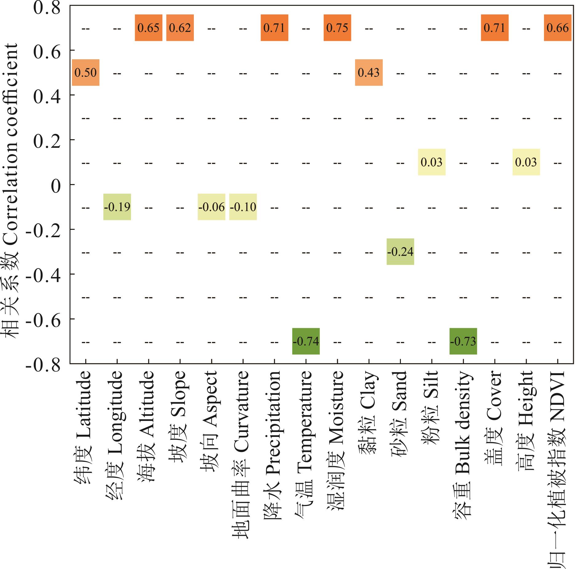
Fig.2 Correlation coefficient between belowground biomass and ecologic factors
指标 Index | 训练数据Training data (n=130) | 验证数据Verification data (n=55) | ||||
|---|---|---|---|---|---|---|
| 0~10 cm | 10~20 cm | 20~30 cm | 0~10 cm | 10~20 cm | 20~30 cm | |
| 最小值Min (g·m-2) | 180.68 | 107.42 | 29.46 | 169.87 | 104.76 | 28.85 |
| 最大值Max (g·m-2) | 2485.20 | 862.95 | 459.54 | 2401.21 | 808.69 | 484.32 |
| 均值Mean (g·m-2) | 809.57 | 326.41 | 150.40 | 815.11 | 329.17 | 162.15 |
| 中位值Median (g·m-2) | 640.69 | 265.79 | 127.52 | 726.24 | 266.06 | 131.59 |
| 偏度Skewness | 0.96 | 0.89 | 0.95 | 1.12 | 0.85 | 0.82 |
Table 1 Descriptive statistics of belowground biomass (BGB) in training data and verification data
指标 Index | 训练数据Training data (n=130) | 验证数据Verification data (n=55) | ||||
|---|---|---|---|---|---|---|
| 0~10 cm | 10~20 cm | 20~30 cm | 0~10 cm | 10~20 cm | 20~30 cm | |
| 最小值Min (g·m-2) | 180.68 | 107.42 | 29.46 | 169.87 | 104.76 | 28.85 |
| 最大值Max (g·m-2) | 2485.20 | 862.95 | 459.54 | 2401.21 | 808.69 | 484.32 |
| 均值Mean (g·m-2) | 809.57 | 326.41 | 150.40 | 815.11 | 329.17 | 162.15 |
| 中位值Median (g·m-2) | 640.69 | 265.79 | 127.52 | 726.24 | 266.06 | 131.59 |
| 偏度Skewness | 0.96 | 0.89 | 0.95 | 1.12 | 0.85 | 0.82 |
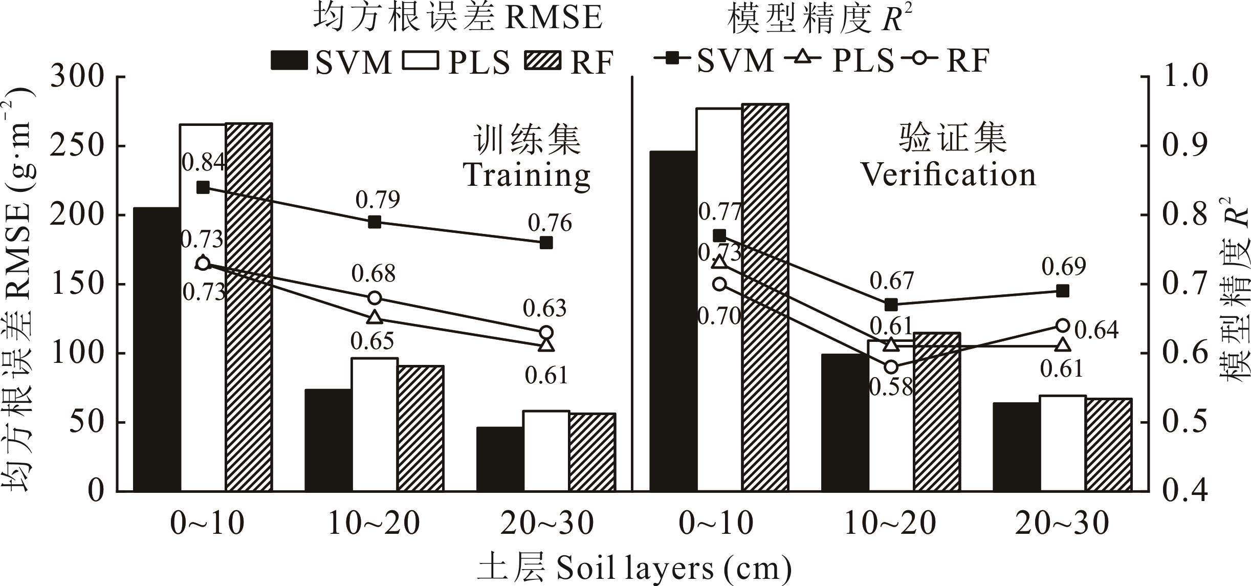
Fig.3 Accuracy of belowground biomass (BGB) estimation by estimation models in different soil layers

Fig.4 Combination accuracy between estimation models and spatial interpolation methods in the 0-10 cm soil layer
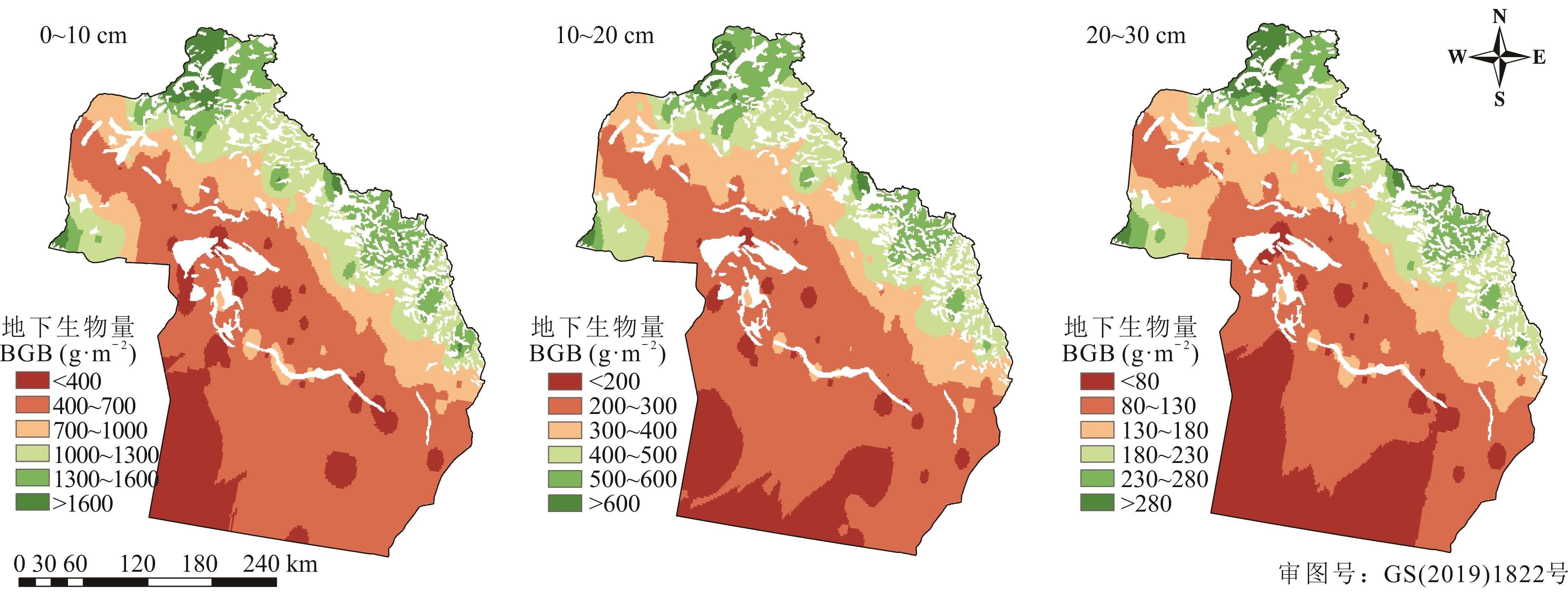
Fig.5 Spatial patterns of grassland belowground biomass (BGB) in Altay region of 2015
| 草地类型Type | 面积Area (km2) | 地下生物量Belowground biomass (t) | 比例Ratio (%) |
|---|---|---|---|
| 低地草甸Lowland meadow | 2370 | 3.26×10⁶ | 2.58 |
| 温性荒漠Temperate desert | 70021 | 5.44×10⁷ | 42.97 |
| 温性荒漠草原Temperate desert steppe | 4543 | 5.26×10⁶ | 4.16 |
| 温性草原Temperate steppe | 9079 | 1.54×10⁷ | 12.19 |
| 温性草甸草原Temperate meadow steppe | 7725 | 2.04×10⁷ | 16.08 |
| 山地草甸Mountain meadow | 6099 | 1.41×10⁷ | 11.17 |
| 高寒草甸Alpine meadow | 4725 | 1.37×10⁷ | 10.86 |
| 合计Total | - | 1.27×10⁸ (≈0.13 Pg) | 100.00 |
Table 2 Belowground biomass in the 0-30 cm soil layer of each grassland type
| 草地类型Type | 面积Area (km2) | 地下生物量Belowground biomass (t) | 比例Ratio (%) |
|---|---|---|---|
| 低地草甸Lowland meadow | 2370 | 3.26×10⁶ | 2.58 |
| 温性荒漠Temperate desert | 70021 | 5.44×10⁷ | 42.97 |
| 温性荒漠草原Temperate desert steppe | 4543 | 5.26×10⁶ | 4.16 |
| 温性草原Temperate steppe | 9079 | 1.54×10⁷ | 12.19 |
| 温性草甸草原Temperate meadow steppe | 7725 | 2.04×10⁷ | 16.08 |
| 山地草甸Mountain meadow | 6099 | 1.41×10⁷ | 11.17 |
| 高寒草甸Alpine meadow | 4725 | 1.37×10⁷ | 10.86 |
| 合计Total | - | 1.27×10⁸ (≈0.13 Pg) | 100.00 |

Fig.6 Belowground biomass (BGB) of different grassland types in the 0-30 cm soil layers during the peak season of 2015
| 1 | Wang J, Sun J, Yu Z, et al. Vegetation type controls root turnover in global grasslands. Global Ecology and Biogeography, 2019, 28(4): 442-455. |
| 2 | Sun Y, Yang Y, Zhao X, et al. Global patterns and climatic drivers of above- and belowground net primary productivity in grasslands. Science China Life Sciences, 2021, 64(5): 739-751. |
| 3 | Pucheta E, Bonamici I, Cabido M, et al. Below-ground biomass and productivity of a grazed site and a neighbouring ungrazed exclosure in a grassland in central Argentina. Austral Ecology, 2004(29): 201-208. |
| 4 | Zhang D D, Wang X M, Zan M. Estimation of vegetation aboveground biomass in the Wei-Ku Oasis based on Landsat 8 OLI images. Acta Prataculturae Sinica, 2021, 30(11): 1-12. |
| 张殿岱, 王雪梅, 昝梅. 基于Landsat 8 OLI影像的渭-库绿洲植被地上生物量估算. 草业学报, 2021, 30(11): 1-12. | |
| 5 | Ghasemi N, Sahebi M R, Mohammadzadeh A. A review on biomass estimation methods using synthetic aperture radar data. International Journal of Geomatics and Geosciences, 2011, 1(4): 776-788. |
| 6 | Sinha S, Jeganathan C, Sharma L K, et al. A review of radar remote sensing for biomass estimation. International Journal of Environmental Science and Technology, 2015, 12(5): 1779-1792. |
| 7 | Tang Z, Deng L, An H, et al. Bayesian method predicts belowground biomass of natural grasslands. Ecoscience, 2017, 24(3): 1-10. |
| 8 | Fierer N, Strickland M S, Liptzin D, et al. Global patterns in belowground communities. Ecology Letters, 2009, 12(11): 1238-1249. |
| 9 | Fan J W, Wang K, Harris W, et al. Allocation of vegetation biomass across a climate-related gradient in the grasslands of Inner Mongolia. Journal of Arid Environments, 2009, 73(4/5): 521-528. |
| 10 | Lopatin J, Kattenborn T, Galleguillos M, et al. Using aboveground vegetation attributes as proxies for mapping peatland belowground carbon stocks. Remote Sensing of Environment, 2019, 231: 111217. |
| 11 | Luo W, Jiang Y, Lv X, et al. Patterns of plant biomass allocation in temperate grasslands across a 2500-km transect in northern China. PLoS One, 2013, 8(8): e71749. |
| 12 | Fiala K, Tůma I, Holub P. Interannual variation in root production in grasslands affected by artificially modified amount of rainfall. Scientific World Journal, 2012, 2012: 805298. |
| 13 | Gill R A, Kelly R H, Parton W J, et al. Using simple environmental variables to estimate below- ground productivity in grasslands. Global Ecology & Biogeography, 2002, 11: 79-86. |
| 14 | Qiao Y X, Zhu H Z, Zhong H P, et al. Spatial interpolation analysis of grassland below-ground biomass in the Inner Mongolia Autonomous Region, China. Acta Prataculturae Sinica, 2016, 25(6): 1-12. |
| 乔宇鑫, 朱华忠, 钟华平, 等. 内蒙古草地地下生物量空间格局分析. 草业学报, 2016, 25(6): 1-12. | |
| 15 | Li H, Jia S, Le Z. Quantitative analysis of soil total nitrogen using hyperspectral imaging technology with extreme learning machine. Sensors, 2019, 19(20): 4355. |
| 16 | O’Connell J L, Byrd K B, Kelly M. A hybrid model for mapping relative differences in belowground biomass and root∶shoot ratios using spectral reflectance, foliar N and plant biophysical data within coastal marsh. Remote Sensing, 2015, 7(12): 16480-16503. |
| 17 | Zhao H H, Li X D, Zhang D, et al. Aboveground biomass in grasslands in Qinghai Province estimated from MODIS data and its influencing factors. Acta Prataculturae Sinica, 2020, 29(12): 5-16. |
| 赵慧芳, 李晓东, 张东, 等. 基于MODIS数据的青海省草地地上生物量估算及影响因素研究. 草业学报, 2020, 29(12): 5-16. | |
| 18 | Bernhardt-Römermann M, Römermann C, Sperlich S, et al. Explaining grassland biomass-the contribution of climate, species and functional diversity depends on fertilization and mowing frequency. Journal of Applied Ecology, 2011, 48(5): 1088-1097. |
| 19 | Schenk H J, Jackson R B. Rooting depths, lateral root spreads and below-ground/above-ground allometries of plants in water-limited ecosystems. Journal of Ecology, 2002, 90(3): 480-494. |
| 20 | Ma X X, Yan Y, Lu X Y, et al. Dynamics of belowground biomass and its relationship with soil moisture in alpine grassland on the North Tibetan Plateau. Ecology and Environmental Sciences, 2016, 25(2): 189-195. |
| 马星星, 鄢燕, 鲁旭阳, 等.藏北高寒草地地下生物量特征及其与土壤水分的关系. 生态环境学报, 2016, 25(2): 189-195. | |
| 21 | Zhu B W, Zhou H K, Xu Y X, et al. Study on seasonal dynamics of biomass in meadow grassland of north shore of Qinghai Lake. Pratacultural Science, 2008, 25(12): 62-66. |
| 朱宝文, 周华坤, 徐有绪, 等. 青海湖北岸草甸草原牧草生物量季节动态研究. 草业科学, 2008, 25(12): 62-66. | |
| 22 | Peng S, Piao S, Ciais P, et al. Asymmetric effects of daytime and night-time warming on northern hemisphere vegetation. Nature, 2013, 501: 88-92. |
| 23 | Mokany K, Raison R J, Prokushkin A S. Critical analysis of root∶shoot ratios in terrestrial biomes. Global Change Biology, 2006, 12: 84-96. |
| 24 | Leonid U, Yuriy R, Vasiliy U, et al. Impact of climate and grazing on biomass components of Eastern Russia typical steppe. Journal of Integrative Agriculture, 2014, 13(6): 1183-1192. |
| 25 | Didiano T J, Johnson M T J, Duval T P. Disentangling the effects of precipitation amount and frequency on the performance of 14 grassland species. PLoS One, 2016, 11(9): e162310. |
| 26 | Xia J, Liu S, Liang S, et al. Spatio-temporal patterns and climate variables controlling of biomass carbon stock of global grassland ecosystems from 1982 to 2006. Remote Sensing, 2014, 6(3): 1783-1802. |
| 27 | Wang L, Niu K, Yang Y, et al. Patterns of above- and belowground biomass allocation in China’s grasslands: Evidence from individual-level observations. Science China Life Sciences, 2010, 53(7): 851-857. |
| 28 | Hu T, Sørensen P, Wahlström E M, et al. Root biomass in cereals, catch crops and weeds can be reliably estimated without considering aboveground biomass. Agriculture, Ecosystems & Environment, 2018, 251: 141-148. |
| 29 | Yang Y, Dou Y, An S. Environmental driving factors affecting plant biomass in natural grassland in the Loess Plateau, China. Ecological Indicators, 2017, 82: 250-259. |
| 30 | Li Y Z, Shao Q Q, Fan J W, et al. Effects of grassland cultivation on ecosystem water use efficiency in a grazed temperate grassland area. Acta Prataculturae Sinica, 2019, 28(10): 110-121. |
| 李愈哲, 邵全琴, 樊江文, 等. 开垦对放牧温性草原生态系统水分利用效率的影响. 草业学报, 2019, 28(10): 110-121. | |
| 31 | Yuen J Q, Ziegler A D, Webb E L, et al. Uncertainty in below-ground carbon biomass for major land covers in Southeast Asia. Forest Ecology and Management, 2013, 310: 915-926. |
| 32 | Lauenroth W K, Wade A A, Williamson M A, et al. Uncertainty in calculations of net primary production for grasslands. Ecosystems, 2006, 9(5): 843-851. |
| 33 | Wilson C H, Strickland M S, Hutchings J A, et al. Grazing enhances belowground carbon allocation, microbial biomass, and soil carbon in a subtropical grassland. Global Change Biology, 2018, 24(7): 2997-3009. |
| 34 | Ren Q, Ai Y, Hu J, et al. Effects of different yak grazing intensities on soil land plant biomass in an alpine meadow on the Qinghai-Tibetan Plateau. Acta Ecologica Sinica, 2021, 41(17): 6862-6870. |
| 任强, 艾鷖, 胡健, 等. 不同强度牦牛放牧对青藏高原高寒草地土壤和植物生物量的影响. 生态学报, 2021, 41(17): 6862-6870. | |
| 35 | Loretta C, Johnson J R M. Fire and grazing regulate belowground processes in tallgrass prairie. Ecology, 2001, 82(12): 3377-3389. |
| 36 | Frank D A. Drought effects on above- and belowground production of a grazed temperate grassland ecosystem. Oecologia, 2007, 152(1): 131-139. |
| 37 | Hao Y, He Z. Effects of grazing patterns on grassland biomass and soil environments in China: A meta-analysis. PLoS One, 2019, 14(4): e215223. |
| 38 | Acosta-Gallo B, Casado M A, Montalvo J, et al. Allometric patterns of below-ground biomass in Mediterranean grasslands. Plant Biosystems, 2011, 145(3): 584-595. |
| 39 | Harpole W S, Sullivan L L, Lind E M, et al. Addition of multiple limiting resources reduces grassland diversity. Nature, 2016, 537: 93-96. |
| [1] | Ge-xia QIN, Jing WU, Chun-bin LI, Zhen-xia JI, Zheng-chao QIU, Ying LI. Inversion of grassland aboveground biomass in Tianzhu Zangzu Autonomous County based on a machine learning algorithm [J]. Acta Prataculturae Sinica, 2022, 31(4): 177-188. |
| [2] | Hui-long LIN, Di FAN, Qi-sheng FENG, Tian-gang LIANG. New focus for the study of the Comprehensive Sequential Classification System for grassland: A review from 2008 to 2020 and prospects for future research [J]. Acta Prataculturae Sinica, 2021, 30(10): 201-213. |
| [3] | Hui-xia LIU, Yi-qiang DONG, Yu-xuan CUI, Xing-hong LIU, Pan-xing HE, Qiang SUN, Zong-jiu SUN. Environmental factors influencing soil organic carbon and its characteristics in desert grassland in Altay, Xinjiang [J]. Acta Prataculturae Sinica, 2021, 30(10): 41-52. |
| [4] | QIAO Yu-Xin, ZHU Hua-Zhong, SHAO Xiao-Ming, ZHONG Hua-Ping, ZHOU Li-Lei, WU Zhao-Wen. Automatic classification of grassland type in Xinjiang Ili based on spatial interpolation of remote sensing and other data [J]. Acta Prataculturae Sinica, 2017, 26(10): 30-45. |
| Viewed | ||||||
|
Full text |
|
|||||
|
Abstract |
|
|||||