

ISSN 1004-5759 CN 62-1105/S
草业学报 ›› 2022, Vol. 31 ›› Issue (12): 41-51.DOI: 10.11686/cyxb2021468
郭恒亮1( ), 李晓2, 付羽3, 乔宝晋2()
收稿日期:2021-12-13
修回日期:2022-01-28
出版日期:2022-12-20
发布日期:2022-10-17
通讯作者:
乔宝晋
作者简介:E-mail: qiaobaojin@zzu.edu.cn基金资助:
Heng-liang GUO1(), Xiao LI2, Yu FU3, Bao-jin QIAO2()
Received:2021-12-13
Revised:2022-01-28
Online:2022-12-20
Published:2022-10-17
Contact:
Bao-jin QIAO
摘要:
准确估算叶面积指数(LAI)在生态、环境和气候变化研究方面具有重要作用。依靠卫星遥感技术能够获取大范围LAI产品,但其空间分辨率较低且依赖大量地面实测数据,难以满足高精度、大范围研究的需求。本研究基于30 m空间分辨率地表反射率数据,在不依赖大量地面实测数据的情况下,提出基于核岭回归算法的PROSAIL物理模型反演LAI,首先对PROSAIL模型的输入参数进行敏感性分析,以确定输入参数并生成模拟数据集,从而建立模拟反射率与LAI之间的核岭回归反演模型,进行高空间分辨率LAI反演,并与基于多层感知机的PROSAIL模型、基于随机森林回归的PROSAIL模型进行对比分析。结果表明:基于核岭回归的PROSAIL模型获得了最高的LAI反演精度,模型决定系数(
郭恒亮, 李晓, 付羽, 乔宝晋. 基于核岭回归算法的PROSAIL模型反演高空间分辨率叶面积指数[J]. 草业学报, 2022, 31(12): 41-51.
Heng-liang GUO, Xiao LI, Yu FU, Bao-jin QIAO. High-resolution leaf area index inversion based on the Kernel Ridge Regression algorithm and PROSAIL model[J]. Acta Prataculturae Sinica, 2022, 31(12): 41-51.
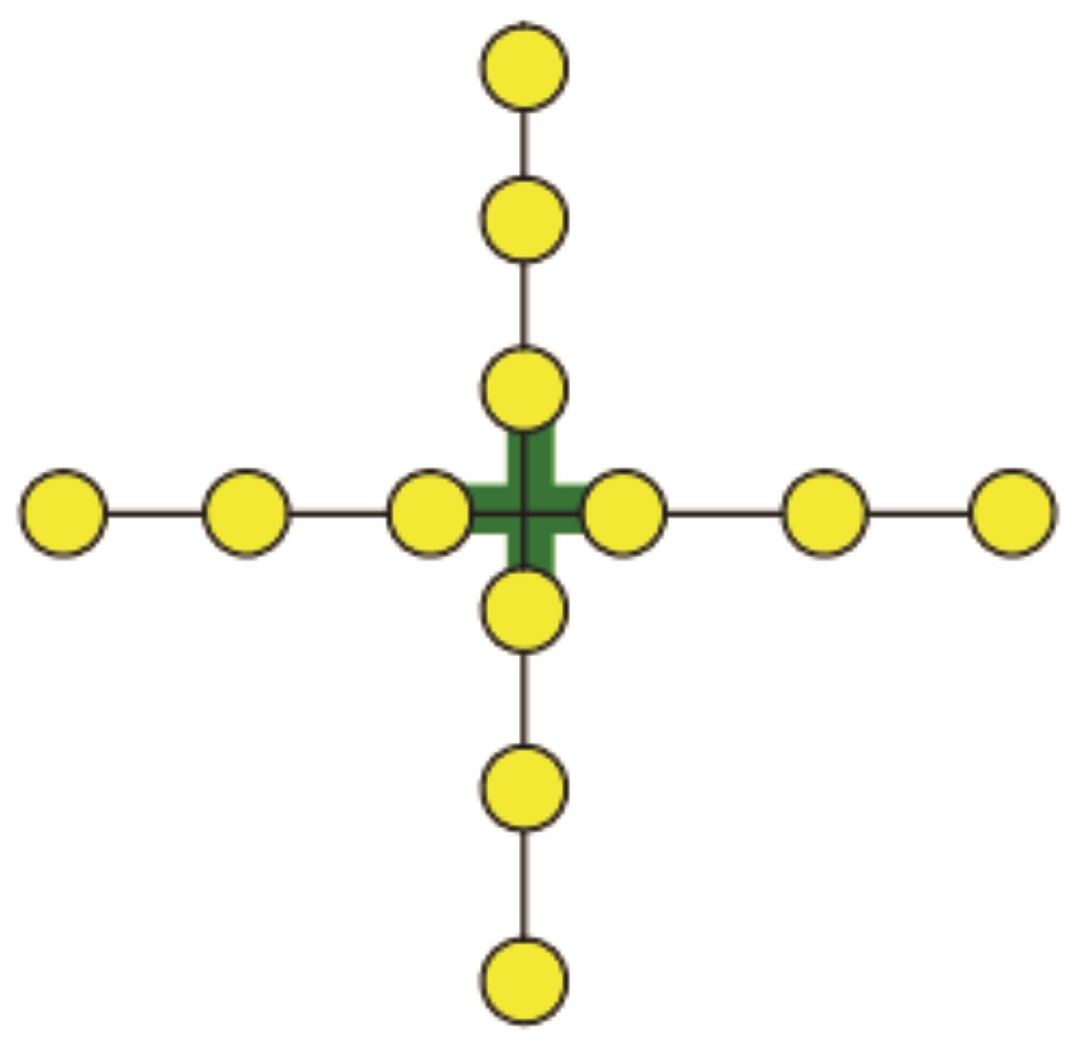
图1 Cross模式示意图
Fig.1 Cross mode diagram
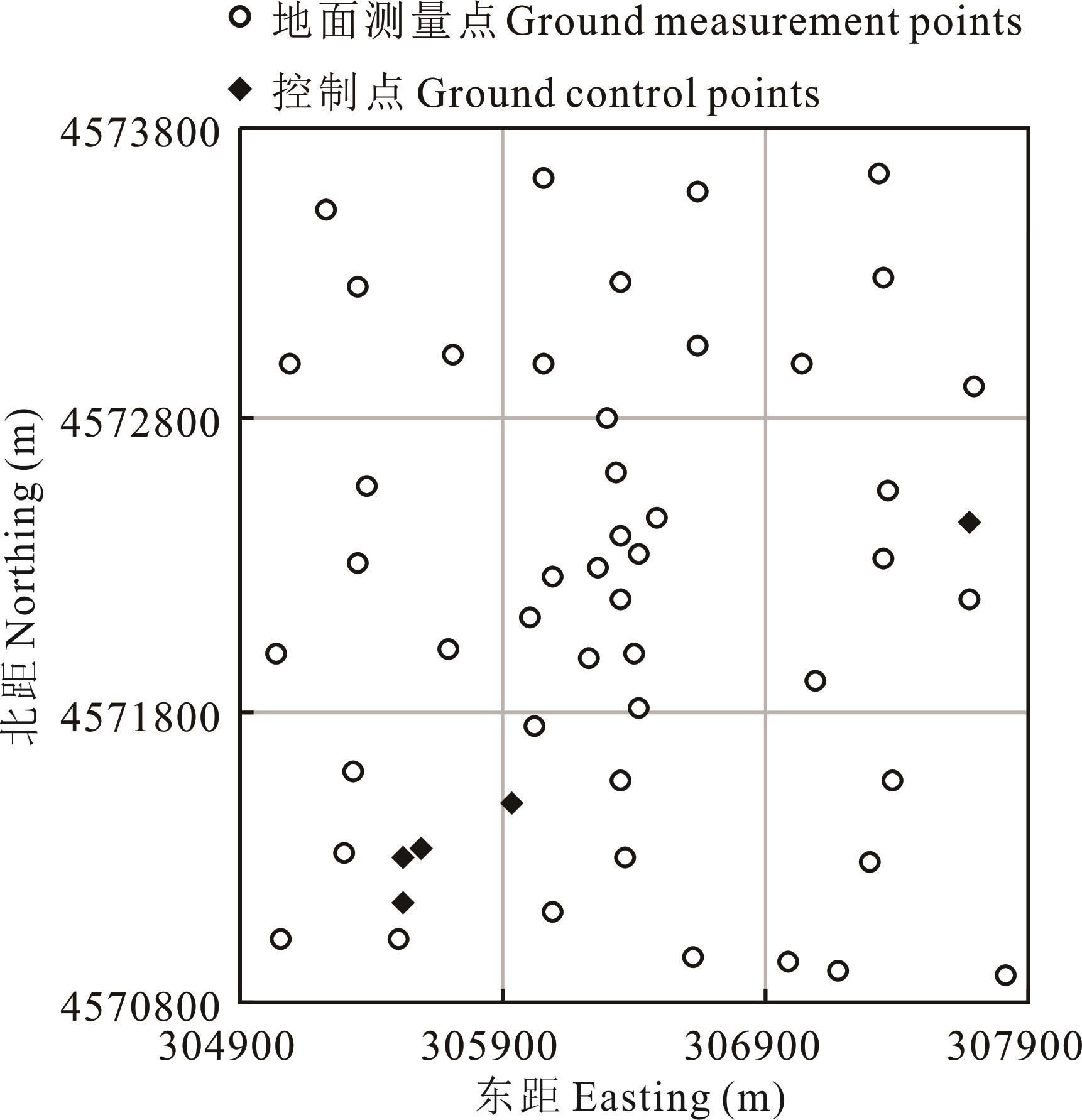
图2 研究区地面测量点与控制点布设情况
Fig.2 Ground measurement points and ground contro points in the study area
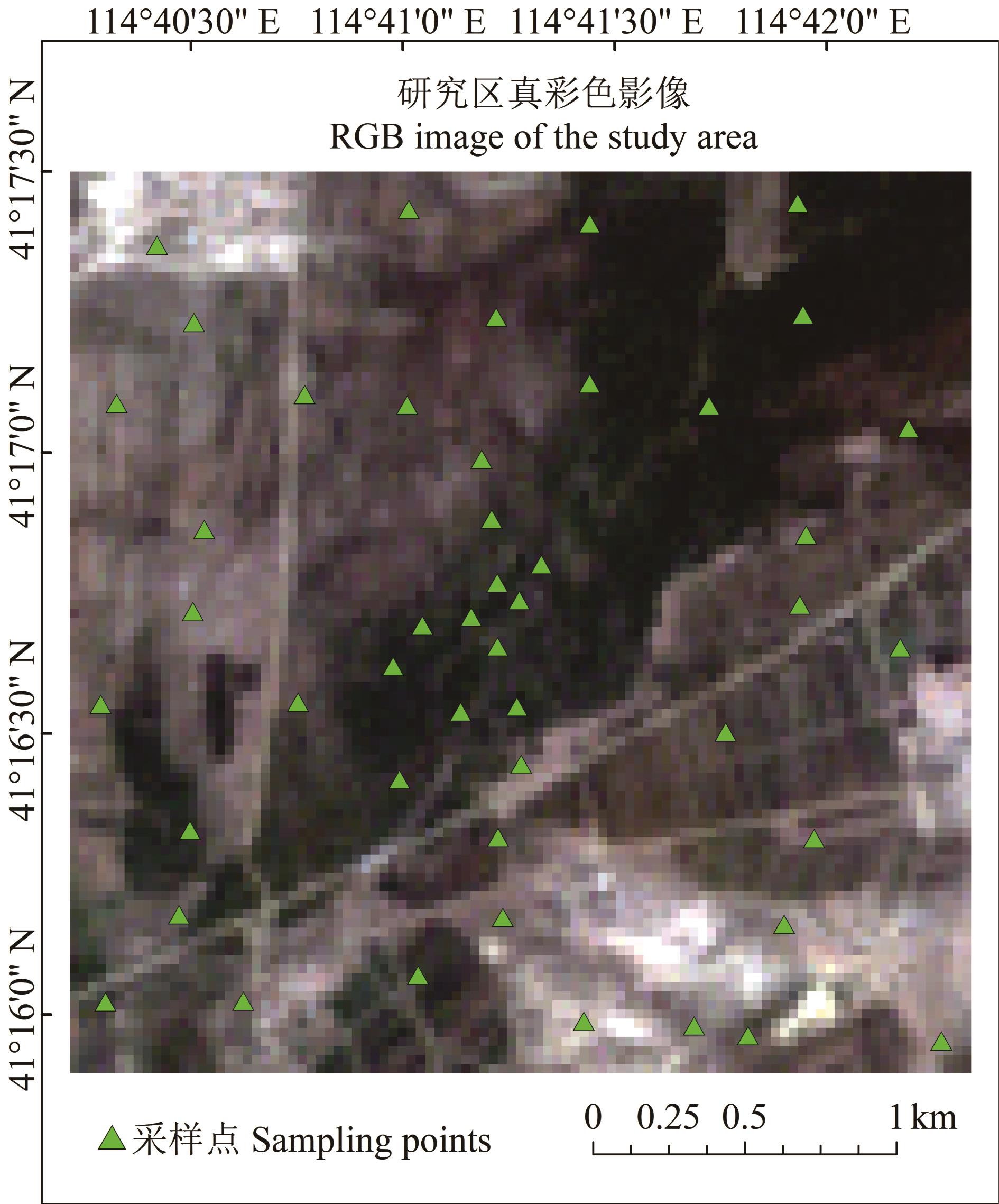
图3 研究区真彩色影像及采样点空间分布
Fig.3 True color images and spatial distribution of sampling points in the study area

图4 基于核岭回归的PROSAIL反演模型流程
Fig.4 Flow chart of KRR-PROSAIL inversion model

图5 PROSAIL模型参数敏感性分析
Fig.5 Parameter sensitivity analysis of PROSAIL model
| 模型输入参数Model input parameter | 取值范围Value range |
|---|---|
| 叶面积指数Leaf area index (LAI) | 0.01~3.00 |
| 叶绿素含量Chlorophyll content (Cab) | 10~80 |
| 平均叶倾角Average leaf angle (ALA) | 20~70 |
| 水分含量Water content (Cw) | 0.004~0.040 |
| 叶片结构参数Leaf structure parameters (N) | 1~2 |
| 土壤湿度Soil moisture (Psoil) | 0.1~1.0 |
表1 PROSAIL模型参数取值范围
Table 1 Parameter ranges of PROSAIL model
| 模型输入参数Model input parameter | 取值范围Value range |
|---|---|
| 叶面积指数Leaf area index (LAI) | 0.01~3.00 |
| 叶绿素含量Chlorophyll content (Cab) | 10~80 |
| 平均叶倾角Average leaf angle (ALA) | 20~70 |
| 水分含量Water content (Cw) | 0.004~0.040 |
| 叶片结构参数Leaf structure parameters (N) | 1~2 |
| 土壤湿度Soil moisture (Psoil) | 0.1~1.0 |
非参数回归模型 Non-parametric regression model | 训练精度Training accuracy | 预测精度Prediction accuracy | ||
|---|---|---|---|---|
| 决定系数 | 均方根误差RMSE | 决定系数 | 均方根误差RMSE | |
| 多层感知机Multilayer perceptron | 0.8014 | 0.2711 | 0.7921 | 0.2570 |
| 随机森林回归Random forest regression | 0.9675 | 0.1142 | 0.7893 | 0.2582 |
| 核岭回归Kernel ridge regression | 0.7879 | 0.2805 | 0.7878 | 0.2593 |
表2 反演模型构建精度对比
Table 2 Comparison of inversion model construction accuracy
非参数回归模型 Non-parametric regression model | 训练精度Training accuracy | 预测精度Prediction accuracy | ||
|---|---|---|---|---|
| 决定系数 | 均方根误差RMSE | 决定系数 | 均方根误差RMSE | |
| 多层感知机Multilayer perceptron | 0.8014 | 0.2711 | 0.7921 | 0.2570 |
| 随机森林回归Random forest regression | 0.9675 | 0.1142 | 0.7893 | 0.2582 |
| 核岭回归Kernel ridge regression | 0.7879 | 0.2805 | 0.7878 | 0.2593 |

图6 非参数回归反演模型验证
Fig.6 Verification of the non-parametric regression inversion model
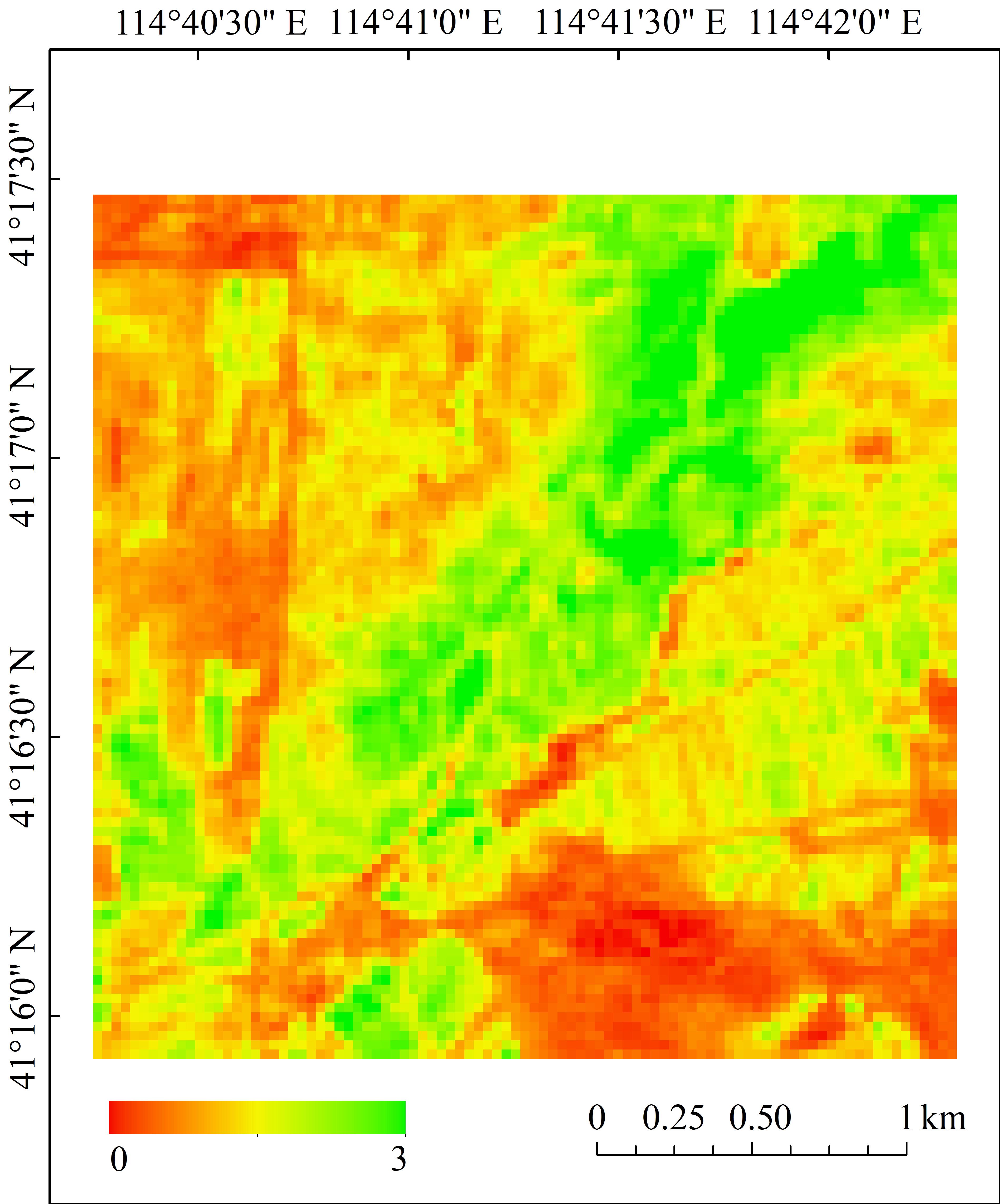
图7 研究区30 m LAI反演空间分布
Fig.7 Spatial distribution of 30 m LAI inversion in the study area
| 1 | Chen J M, Black T A. Defining leaf area index for non-flat leaves. Plant, Cell & Environment, 1992, 15(4): 421-429. |
| 2 | Chen Y P, Sun K M, Chen C, et al. Generation and evaluation of LAI and FPAR products from Himawari-8 advanced Himawari imager (AHI) data. Remote Sensing, 2019, 11(13): 1517. |
| 3 | Song Y, Wang J F, Shang J L, et al. Using UAV-based SOPC derived LAI and SAFY model for biomass and yield estimation of winter wheat. Remote Sensing, 2020, 12(15): 2378. |
| 4 | Chen Y Z, Chen L Y, Cheng Y, et al. Afforestation promotes the enhancement of forest LAI and NPP in China. Forest Ecology and Management, 2020, 462: 117990. |
| 5 | Darvishzadeh R, Wang T J, Skidmore A, et al. Analysis of Sentinel-2 and rapideye for retrieval of leaf area index in a saltmarsh using a radiative transfer model. Journal of Engineering, 2019, 11(6): 671. |
| 6 | Yan G J, Hu R H, Luo J H, et al. Review of indirect optical measurements of leaf area index: Recent advances, challenges, and perspectives. Agricultural & Forest Meteorology, 2019, 265: 390-411. |
| 7 | Zhang J Y, Wang J D, Shi Y C. An approach to estimate forest LAI with high resolution based on prior knowledge of model parameters. Journal of Remote Sensing, 2020, 24(11): 1342-1352. |
| 张静宇, 王锦地, 石月婵. 基于森林模型参数先验知识估算高分辨率叶面积指数. 遥感学报, 2020, 24(11): 1342-1352. | |
| 8 | Yu Q H, Yang G J, Wang C C. Chlorophyll inversion of winter wheat based on ground hyperspectral data and PROSAIL model. Science of Surveying and Mapping, 2019, 44(11): 96-102,136. |
| 于汧卉, 杨贵军, 王崇倡. 地面高光谱和PROSAIL模型的冬小麦叶绿素反演. 测绘科学, 2019, 44(11): 96-102,136. | |
| 9 | Yao X, Yu K Y, Liu J. Leaf area index estimation of masson pine (Pinus massoniana) forests based on multispectral remote sensing of UAV. Transactions of the Chinese Society for Agricultural Machinery, 2021, 52(7): 213-221. |
| 姚雄, 余坤勇, 刘健. 基于无人机多光谱遥感的马尾松林叶面积指数估测. 农业机械学报, 2021, 52(7): 213-221. | |
| 10 | Zhang S, Liu L Y, Huang W J. Retrieval of canopy chlorophyll density based on hyperpectral vegetation indices. Remote Sensing Information, 2013, 28(3): 94-101,111. |
| 张苏, 刘良云, 黄文江. 基于植被指数的叶绿素密度遥感反演建模与适用性研究. 遥感信息, 2013, 28(3): 94-101, 111. | |
| 11 | Chen J M, Cihlar J. Retrieving leaf area index of boreal conifer forests using Landsat TM images. Remote Sensing of Environment, 1996, 55(2): 153-162. |
| 12 | Turner D P, Cohen W B, Kennedy R E, et al. Relationships between leaf area index and Landsat TM spectral vegetation indices across three temperate zone sites. Remote Sensing of Environment, 1999, 70(1): 52-68. |
| 13 | Hu G Y, Li S D, Yang R H. Comparsion of three regression models for remote sensing estimation of leaf area index. Science of Surveying and Mapping, 2018, 43(10): 46-50, 66. |
| 胡古月, 李少达, 杨容浩. 叶面积指数遥感估算的三种回归模型分析. 测绘科学, 2018, 43(10): 46-50, 66. | |
| 14 | Darvishzadeh R, Skidmore A, Schlerf M, et al. Inversion of a radiative transfer model for estimating vegetation LAI and chlorophyll in a heterogeneous grassland. Remote Sensing of Environment, 2008, 112(5): 2592-2604. |
| 15 | Jacquemoud S, Verhoef W, Baret F, et al. PROSPECT+SAIL models: A review of use for vegetation characterization. Remote Sensing of Environment, 2009, 113(1): S56-S66. |
| 16 | Su W, Yao C, Li Y, et al. LAI retrieving of corn canopy based on SupReMe image reconstruction and random forest. Transactions of the Chinese Society for Agricultural Machinery, 2021, 52(4): 190-196, 256. |
| 苏伟, 姚婵, 李颖, 等. 基于SupReMe影像重建和RF的玉米冠层LAI反演. 农业机械学报, 2021, 52(4): 190-196, 256. | |
| 17 | Guo Y K, Liu Y L, Zhang X J, et al. LAI inversion using radiation transfer model and random forest regression. Engineering of Surveying and Mapping, 2020, 29(3): 33-38. |
| 郭云开, 刘雨玲, 张晓炯, 等. 利用辐射传输模型和随机森林回归反演LAI. 测绘工程, 2020, 29(3): 33-38. | |
| 18 | Fang H L. Development and validation of satellite leaf area index (LAI) products in China. Remote Sensing Technology and Application, 2020, 35(5): 990-1003. |
| 方红亮. 我国叶面积指数卫星遥感产品生产及验证. 遥感技术与应用, 2020, 35(5): 990-1003. | |
| 19 | Zhou H M, Zhang G D, Wang C J, et al. Time series high-resolution leaf area index estimation and change monitoring in the Saihanba area. Journal of Remote Sensing, 2021, 25(4): 1000-1012. |
| 周红敏, 张国东, 王昶景, 等. 塞罕坝地区高空间分辨率叶面积指数时序估算与变化检测. 遥感学报, 2021, 25(4): 1000-1012. | |
| 20 | Li Z W, Xin X P, Tang H, et al. Estimating grassland LAI using the Random Forests approach and Landsat imagery in the meadow steppe of Hulunber, China. Journal of Integrative Agriculture, 2017, 16(2): 286-297. |
| 21 | Baret F, Weiss M, Allard D, et al. VALERI: A network of sites and a methodology for the validation of medium spatial resolution land satellite products. http://w3.avignon.inra.fr/valeri/, 2002-06-26. |
| 22 | Fang H L. Scaling effects of the true and effective leaf area index (LAI and LAIe) and clumping index (CI). Journal of Geo-information Science, 2021, 23(7): 1155-1168. |
| 方红亮. 真实和有效叶面积指数及聚集指数的尺度效应. 地球信息科学学报, 2021, 23(7): 1155-1168. | |
| 23 | Jacquemoud S, Baret F. PROSPECT: A model of leaf optical properties spectra. Remote Sensing of Environment, 1990, 34(2): 75-91. |
| 24 | Verhoef W. Light scattering by leaf layers with application to canopy reflectance modeling: The SAIL model. Remote Sensing of Environment, 1984, 16(2): 125-141. |
| 25 | Cui J T, Ding J H, Yesilekin N, et al. Sensitivity analysis of soil input parameters of CERES-Wheat model based on EFAST method. Transactions of the Chinese Society for Agricultural Machinery, 2020, 51(12): 276-283. |
| 崔金涛, 丁继辉, Yesilekin N, 等. 基于EFAST的CERES-Wheat模型土壤参数敏感性分析. 农业机械学报, 2020, 51(12): 276-283. | |
| 26 | Ma J W, Huang S F, Li J R, et al. Global sensitivity analysis of parameters in the PROSAIL model based on modified Sobol’s method. Bulletin of Surveying and Mapping, 2016, 468(3): 33-35. |
| 马建威, 黄诗峰, 李纪人, 等. 改进Sobol算法支持下的PROSAIL模型参数全局敏感性分析. 测绘通报, 2016, 468(3): 33-35. | |
| 27 | Fang S, Gertner G, Shinkareva S, et al. Improved generalized fourier amplitude sensitivity test (FAST) for model assessment. Statistics and Computing, 2003, 13(3): 221-226. |
| 28 | He W, Yang H. EFAST method for global sensitivity analysis of remote sensing model’s parameters. Remote Sensing Technology and Application, 2013, 28(5): 836-843. |
| 何维, 杨华. 模型参数全局敏感性分析的EFAST方法. 遥感技术与应用, 2013, 28(5): 836-843. | |
| 29 | Liu E J, Song Y S, Liang J Y. An accelerator for kernel ridge regression algorithms based on data partition. Journal of University of Science and Technology of China, 2018, 48(4): 284-289. |
| 刘恩江, 宋云胜, 梁吉业. 基于数据划分的核岭回归加速算法. 中国科学技术大学学报, 2018, 48(4): 284-289. | |
| 30 | Yang Y, James D, Cho J H, et al. Accurate, fast and scalable Kernel ridge regression on parallel and distributed systems// Proceedings of the 2018 international conference on supercomputing. New York: Association for Computing Machinery, 2018: 307-317. |
| 31 | Lin J, Rudi A, Rosasco L, et al. Optimal rates for spectral algorithms with least-squares regression over Hilbert spaces. Applied and Computational Harmonic Analysis, 2020, 48(3): 868-890. |
| 32 | Ali M, Prasad R, Xiang Y, et al. Complete ensemble empirical mode decomposition hybridized with random forest and Kernel ridge regression model for monthly rainfall forecasts. Journal of Hydrology, 2020, 584: 124647. |
| 33 | Zhang Y, Duchi J, Wainwright M. Divide and conquer kernel ridge regression: A distributed algorithm with minimax optimal rates. Journal of Machine Learning Research, 2015, 16(1): 3299-3340. |
| 34 | Wen B W, Dong W H, Xie W J, et al. Parameter optimization method for random forest based on improved grid search algorithm. Computer Engineering and Applications, 2018, 54(10): 154-157. |
| 温博文, 董文瀚, 解武杰, 等. 基于改进网格搜索算法的随机森林参数优化. 计算机工程与应用, 2018, 54(10): 154-157. | |
| 35 | Csepe Z, Makra L, Voukantsis D, et al. Predicting daily ragweed pollen concentrations using computational intelligence techniques over two heavily polluted areas in Europe. Science of the Total Environment, 2014, 476/477: 542-552. |
| 36 | Breiman L. Random Forests. Machine Learning, 2001, 45(1): 5-32. |
| 37 | Su W, Wu J Y, Wang X S, et al. Retrieving corn canopy leaf area index based on Sentinel-2 image and PROSAIL model parameter calibration. Spectroscopy and Spectral Analysis, 2021, 41(6): 1891-1897. |
| 苏伟, 邬佳昱, 王新盛, 等. 基于Sentinel-2影像与PROSAIL模型参数标定的玉米冠层LAI反演. 光谱学与光谱分析, 2021, 41(6): 1891-1897. | |
| 38 | Jiang H Y, Chai L N, Jia K, et al. Estimation of water content for short vegetation based on PROSAIL model and vegetation water indices. Journal of Remote Sensing, 2021, 25(4): 1025-1036. |
| 江海英, 柴琳娜, 贾坤, 等. 联合PROSAIL模型和植被水分指数的低矮植被含水量估算. 遥感学报, 2021, 25(4): 1025-1036. | |
| 39 | Ali A M, Darvishzadeh R, Skidmore A, et al. Machine learning methods’ performance in radiative transfer model inversion to retrieve plant traits from Sentinel-2 data of a mixed mountain forest. International Journal of Digital Earth, 2021, 14(1): 106-120. |
| [1] | 张殿岱, 王雪梅, 昝梅. 基于Landsat 8 OLI影像的渭-库绿洲植被地上生物量估算[J]. 草业学报, 2021, 30(11): 1-12. |
| [2] | 葛静, 孟宝平, 杨淑霞, 高金龙, 殷建鹏, 张仁平, 冯琦胜, 梁天刚. 基于ADC和MODIS遥感数据的高寒草地地上生物量监测研究——以黄河源区为例[J]. 草业学报, 2017, 26(7): 23-34. |
| [3] | 葛静, 孟宝平, 杨淑霞, 高金龙, 冯琦胜, 梁天刚, 黄晓东, 高新华, 李文龙, 张仁平, 王云龙. 基于UAV技术和MODIS遥感数据的高寒草地盖度动态变化监测研究—以黄河源东部地区为例[J]. 草业学报, 2017, 26(3): 1-12. |
| [4] | 孟宝平, 崔霞, 杨淑霞, 高金龙, 胡远宁, 陈思宇, 梁天刚. 基于Landsat 8 OLI和MODIS数据的高寒草地盖度升尺度效应研究——以夏河县桑科草原试验区为[J]. 草业学报, 2016, 25(7): 1-12. |
| [5] | 张旭琛, 朱华忠, 钟华平, 程耀东, 靳瑰丽, 邵小明. 新疆伊犁地区草地植被地上生物量遥感反演[J]. 草业学报, 2015, 24(6): 25-34. |
| 阅读次数 | ||||||
|
全文 |
|
|||||
|
摘要 |
|
|||||