
ISSN 1004-5759 CN 62-1105/S
Acta Prataculturae Sinica ›› 2021, Vol. 30 ›› Issue (10): 1-14.DOI: 10.11686/cyxb2020496
Jie SONG1,2( ), Xue-lu LIU1,2()
Received:2020-11-03
Revised:2020-12-24
Online:2021-09-16
Published:2021-09-16
Contact:
Xue-lu LIU
Jie SONG, Xue-lu LIU. Improving the accuracy of forest identification in mountainous areas from multi-source remote sensing data——the Sunan County section of Qilian Mountains National Park as an example[J]. Acta Prataculturae Sinica, 2021, 30(10): 1-14.

Fig.1 The location of study area
产品号 Product ID | 获取时间 Acquisition date (月-日 Month-day) | 景中心坐标 Center coordinate | 太阳高度角 Sun elevation (°) | 太阳方位角 Sun azimuth (°) | 云覆盖量 Land cloud cover (%) |
|---|---|---|---|---|---|
| 132034 | 7-12 | 37°28′28″ N 101°56′45″ E | 65.39 | 122.77 | 1.85 |
| 133033 | 8-21 | 38°54′16″ N 100°50′15″ E | 48.21 | 151.38 | 0.78 |
| 134033 | 7-28 | 38°54′15″ N 99°17′01″ E | 45.88 | 153.65 | 2.04 |
| 135033 | 7-17 | 38°54′16″ N 97°44′49″ E | 64.15 | 126.85 | 2.63 |
Table 1 The basic parameters of Landsat OLI images
产品号 Product ID | 获取时间 Acquisition date (月-日 Month-day) | 景中心坐标 Center coordinate | 太阳高度角 Sun elevation (°) | 太阳方位角 Sun azimuth (°) | 云覆盖量 Land cloud cover (%) |
|---|---|---|---|---|---|
| 132034 | 7-12 | 37°28′28″ N 101°56′45″ E | 65.39 | 122.77 | 1.85 |
| 133033 | 8-21 | 38°54′16″ N 100°50′15″ E | 48.21 | 151.38 | 0.78 |
| 134033 | 7-28 | 38°54′15″ N 99°17′01″ E | 45.88 | 153.65 | 2.04 |
| 135033 | 7-17 | 38°54′16″ N 97°44′49″ E | 64.15 | 126.85 | 2.63 |
坡度等级 Slope gradient classes | 模型决定系数 Coefficient of determination (R2) | 均方根误差 Root mean square error (RMSE)(m) | ||
|---|---|---|---|---|
| 校正前Before correction | 校正后After correction | 校正前Before correction | 校正后After correction | |
| 0°~5° | 0.62 | 0.66 | 2.83 | 1.84 |
| 5°~15° | 0.64 | 0.65 | 3.32 | 2.23 |
| 15°~25° | 0.66 | 0.67 | 6.74 | 3.51 |
| 25°~35° | 0.63 | 0.65 | 8.00 | 3.91 |
| 35°~58° | 0.65 | 0.67 | 12.59 | 3.48 |
Table 2 Accuracy comparison of GLAS derived canopy heights before and after topographic correction in different slope gradient classes
坡度等级 Slope gradient classes | 模型决定系数 Coefficient of determination (R2) | 均方根误差 Root mean square error (RMSE)(m) | ||
|---|---|---|---|---|
| 校正前Before correction | 校正后After correction | 校正前Before correction | 校正后After correction | |
| 0°~5° | 0.62 | 0.66 | 2.83 | 1.84 |
| 5°~15° | 0.64 | 0.65 | 3.32 | 2.23 |
| 15°~25° | 0.66 | 0.67 | 6.74 | 3.51 |
| 25°~35° | 0.63 | 0.65 | 8.00 | 3.91 |
| 35°~58° | 0.65 | 0.67 | 12.59 | 3.48 |
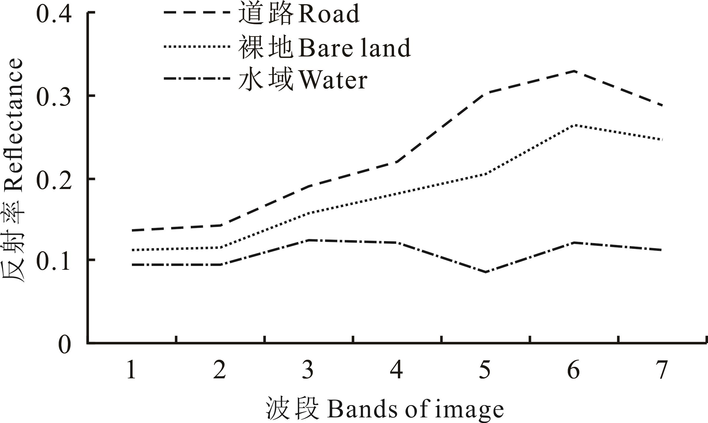
Fig.2 Average spectral curves of road, bare land and water
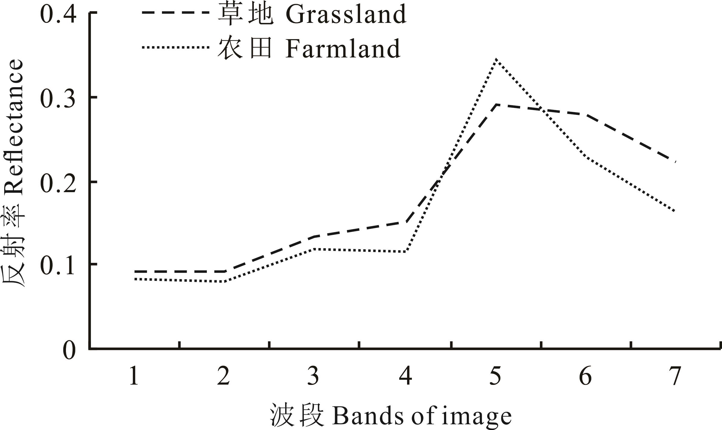
Fig.3 Average spectral curves of grassland and farmland
OLI波段组合 OLI band combination | 依据光谱特征分类 Classification based on spectrum | 依据光谱和垂直结构综合特征分类 Classification based on spectrum and vertical structure | ||
|---|---|---|---|---|
总体精度 Overall accuracy (%) | Kappa系数 Kappa coefficient | 总体精度 Overall accuracy (%) | Kappa系数 Kappa coefficient | |
| 近红外波段、红波段、绿波段NIR、Red、Green | 82.41 | 0.79 | 93.08 | 0.91 |
| 近红外波段、短波红外1、蓝波段NIR、SWIR1、Blue | 82.41 | 0.79 | 93.08 | 0.91 |
| 短波红外1、近红外波段、红波段SWIR1、NIR、Red | 82.41 | 0.79 | 93.08 | 0.91 |
| 短波红外1、近红外波段、蓝波段SWIR1、NIR、Blue | 82.41 | 0.79 | 93.08 | 0.91 |
| 红波段、绿波段、蓝波段Red、Green、Blue | 82.41 | 0.79 | 93.08 | 0.91 |
Table 3 Comparison of classification results based on different features of different band combination and classification methods
OLI波段组合 OLI band combination | 依据光谱特征分类 Classification based on spectrum | 依据光谱和垂直结构综合特征分类 Classification based on spectrum and vertical structure | ||
|---|---|---|---|---|
总体精度 Overall accuracy (%) | Kappa系数 Kappa coefficient | 总体精度 Overall accuracy (%) | Kappa系数 Kappa coefficient | |
| 近红外波段、红波段、绿波段NIR、Red、Green | 82.41 | 0.79 | 93.08 | 0.91 |
| 近红外波段、短波红外1、蓝波段NIR、SWIR1、Blue | 82.41 | 0.79 | 93.08 | 0.91 |
| 短波红外1、近红外波段、红波段SWIR1、NIR、Red | 82.41 | 0.79 | 93.08 | 0.91 |
| 短波红外1、近红外波段、蓝波段SWIR1、NIR、Blue | 82.41 | 0.79 | 93.08 | 0.91 |
| 红波段、绿波段、蓝波段Red、Green、Blue | 82.41 | 0.79 | 93.08 | 0.91 |
分类依据 Classification basis | 地类 Land type | 森林 Forest | 灌木 Shrub | 草地 Grassland | 农田 Farmland | 裸地 Bare land | 建设用地 Built-up area | 水域 Water | 用户精度 User accuracy (%) |
|---|---|---|---|---|---|---|---|---|---|
光谱特征 Spectrum | 森林 Forest | 537 | 189 | 0 | 0 | 0 | 1 | 42 | 69.83 |
| 灌木 Shrub | 22 | 454 | 70 | 0 | 8 | 31 | 0 | 77.61 | |
| 草地 Grassland | 0 | 6 | 82 | 11 | 0 | 20 | 0 | 68.91 | |
| 农田 Farmland | 0 | 19 | 13 | 335 | 0 | 24 | 0 | 85.68 | |
| 裸地 Bare land | 0 | 6 | 0 | 0 | 273 | 30 | 0 | 88.35 | |
| 建设用地 Built-up area | 0 | 30 | 25 | 0 | 14 | 172 | 0 | 71.37 | |
| 水域 Water | 4 | 1 | 0 | 0 | 30 | 42 | 1136 | 93.65 | |
| 制图精度Producer accuracy (%) | 95.38 | 64.40 | 43.16 | 96.82 | 84.00 | 53.75 | 96.43 | - | |
光谱与垂直结构综合特征 Spectrum and vertical structure | 森林 Forest | 556 | 53 | 0 | 0 | 0 | 0 | 0 | 91.30 |
| 灌木 Shrub | 5 | 629 | 27 | 2 | 0 | 20 | 0 | 92.09 | |
| 草地 Grassland | 0 | 5 | 141 | 25 | 19 | 0 | 0 | 74.21 | |
| 农田 Farmland | 0 | 3 | 14 | 319 | 0 | 0 | 0 | 94.94 | |
| 裸地 Bare land | 2 | 15 | 8 | 0 | 271 | 17 | 0 | 86.58 | |
| 建设用地 Built-up area | 0 | 0 | 0 | 0 | 12 | 282 | 0 | 95.92 | |
| 水域 Water | 0 | 0 | 0 | 0 | 24 | 0 | 1178 | 98.00 | |
| 制图精度Producer accuracy (%) | 98.76 | 89.22 | 74.21 | 92.20 | 83.13 | 88.40 | 100.00 | - |
Table 4 Comparison of classification accuracy of different land types based on different classification characteristics
分类依据 Classification basis | 地类 Land type | 森林 Forest | 灌木 Shrub | 草地 Grassland | 农田 Farmland | 裸地 Bare land | 建设用地 Built-up area | 水域 Water | 用户精度 User accuracy (%) |
|---|---|---|---|---|---|---|---|---|---|
光谱特征 Spectrum | 森林 Forest | 537 | 189 | 0 | 0 | 0 | 1 | 42 | 69.83 |
| 灌木 Shrub | 22 | 454 | 70 | 0 | 8 | 31 | 0 | 77.61 | |
| 草地 Grassland | 0 | 6 | 82 | 11 | 0 | 20 | 0 | 68.91 | |
| 农田 Farmland | 0 | 19 | 13 | 335 | 0 | 24 | 0 | 85.68 | |
| 裸地 Bare land | 0 | 6 | 0 | 0 | 273 | 30 | 0 | 88.35 | |
| 建设用地 Built-up area | 0 | 30 | 25 | 0 | 14 | 172 | 0 | 71.37 | |
| 水域 Water | 4 | 1 | 0 | 0 | 30 | 42 | 1136 | 93.65 | |
| 制图精度Producer accuracy (%) | 95.38 | 64.40 | 43.16 | 96.82 | 84.00 | 53.75 | 96.43 | - | |
光谱与垂直结构综合特征 Spectrum and vertical structure | 森林 Forest | 556 | 53 | 0 | 0 | 0 | 0 | 0 | 91.30 |
| 灌木 Shrub | 5 | 629 | 27 | 2 | 0 | 20 | 0 | 92.09 | |
| 草地 Grassland | 0 | 5 | 141 | 25 | 19 | 0 | 0 | 74.21 | |
| 农田 Farmland | 0 | 3 | 14 | 319 | 0 | 0 | 0 | 94.94 | |
| 裸地 Bare land | 2 | 15 | 8 | 0 | 271 | 17 | 0 | 86.58 | |
| 建设用地 Built-up area | 0 | 0 | 0 | 0 | 12 | 282 | 0 | 95.92 | |
| 水域 Water | 0 | 0 | 0 | 0 | 24 | 0 | 1178 | 98.00 | |
| 制图精度Producer accuracy (%) | 98.76 | 89.22 | 74.21 | 92.20 | 83.13 | 88.40 | 100.00 | - |
项目 Item | 森林 Forest | 灌木 Shrub | 草地 Grassland | 农田 Farmland | 裸地 Bare land | 建设用地 Built-up area | 水域 Water |
|---|---|---|---|---|---|---|---|
| 调查及解译结果Inventory and interpretation results (hm2) | 69068 | 173283 | 74569 | 430 | 47230 | 492 | 2042 |
| 影像分类结果Image classification results (hm2) | 66883 | 157432 | 86444 | 403 | 53337 | 550 | 2065 |
| 相对精度Relative accuracy (%) | 96.84 | 90.85 | 86.26 | 93.78 | 88.55 | 89.43 | 98.90 |
| 平均相对精度Mean relative accuracy (%) | 92.09 |
Table 5 Area statistics and comparative analysis of different classified land types
项目 Item | 森林 Forest | 灌木 Shrub | 草地 Grassland | 农田 Farmland | 裸地 Bare land | 建设用地 Built-up area | 水域 Water |
|---|---|---|---|---|---|---|---|
| 调查及解译结果Inventory and interpretation results (hm2) | 69068 | 173283 | 74569 | 430 | 47230 | 492 | 2042 |
| 影像分类结果Image classification results (hm2) | 66883 | 157432 | 86444 | 403 | 53337 | 550 | 2065 |
| 相对精度Relative accuracy (%) | 96.84 | 90.85 | 86.26 | 93.78 | 88.55 | 89.43 | 98.90 |
| 平均相对精度Mean relative accuracy (%) | 92.09 |
分类依据 Classification basis | 总体精度 Overall accuracy | 1770~2770 m海拔精度 Accuracy of altitude (%) | 2770~3770 m海拔精度 Accuracy of altitude (%) | 阴坡精度 Accuracy of shady slope (%) | 阳坡精度 Accuracy of sunny slope (%) | 半阴坡精度 Accuracy of half shady slope (%) | 半阳坡精度 Accuracy of half sunny slope (%) | |
|---|---|---|---|---|---|---|---|---|
分类精度 Accuracy (%) | Kappa系数 Kappa coefficient | |||||||
| 随机样本Random sample | 65.52 | 0.43 | 68.14 | 63.99 | 73.77 | 72.59 | 69.72 | 72.67 |
| 海拔特征样本Altitude sample | 72.36 | 0.55 | 77.36 | 71.07 | - | - | - | - |
| 坡向特征样本Aspect sample | 87.44 | 0.75 | - | - | 91.55 | 82.11 | 91.48 | 85.34 |
| 海拔及坡向特征样本Altitude and aspect sample | 89.46 | 0.79 | 90.14 | 91.10 | 93.16 | 84.25 | 92.36 | 89.22 |
Table 6 Comparative analysis of the effect of terrain information on the accuracy of forest types classification
分类依据 Classification basis | 总体精度 Overall accuracy | 1770~2770 m海拔精度 Accuracy of altitude (%) | 2770~3770 m海拔精度 Accuracy of altitude (%) | 阴坡精度 Accuracy of shady slope (%) | 阳坡精度 Accuracy of sunny slope (%) | 半阴坡精度 Accuracy of half shady slope (%) | 半阳坡精度 Accuracy of half sunny slope (%) | |
|---|---|---|---|---|---|---|---|---|
分类精度 Accuracy (%) | Kappa系数 Kappa coefficient | |||||||
| 随机样本Random sample | 65.52 | 0.43 | 68.14 | 63.99 | 73.77 | 72.59 | 69.72 | 72.67 |
| 海拔特征样本Altitude sample | 72.36 | 0.55 | 77.36 | 71.07 | - | - | - | - |
| 坡向特征样本Aspect sample | 87.44 | 0.75 | - | - | 91.55 | 82.11 | 91.48 | 85.34 |
| 海拔及坡向特征样本Altitude and aspect sample | 89.46 | 0.79 | 90.14 | 91.10 | 93.16 | 84.25 | 92.36 | 89.22 |

Fig.4 Forest types and land cover distribution of study area
| 1 | Pan Y D, Birdsey R A, Fang J Y, et al. A large and persistent carbon sink in the world’s forests. Science, 2011, 333(6045): 988-993. |
| 2 | Grondin P, Gauthier S, Borcard D, et al. A new approach to ecological land classification for the Canadian boreal forest that integrates disturbances. Landscape Ecology, 2014, 29(1): 1-16. |
| 3 | He X Y, Ren C Y, Chen L, et al. The progress of forest ecosystems monitoring with remote sensing techniques. Scientia Geographica Sinica, 2018, 38(7): 997-1011. |
| 何兴元, 任春颖, 陈琳, 等. 森林生态系统遥感监测技术研究进展. 地理科学, 2018, 38(7): 997-1011. | |
| 4 | Global Observation of Forest and Land Cover Dynamics. A sourcebook of methods and procedures for monitoring and reporting anthropogenic greenhouse gas emissions and removals associated with deforestation, gains and losses of carbon stocks in forests remaining forests, and forestation. GOFC-GOLD Report Version COP19-2, GOFC-GOLD land cover project office. Wageningen: Wageningen University, 2014. |
| 5 | Fang X F,Tan B X, Du H Q, et al. Suitability of band width for Hyperion image classification based on wavelet analysis. Journal of Nanjing Forestry University: Natural Sciences Edition, 2018, 42(5): 141-147. |
| 房秀凤, 谭炳香, 杜华强, 等. 基于小波分析的Hyperion影像地物分类波段宽度. 南京林业大学学报: 自然科学版, 2018, 42(5): 141-147. | |
| 6 | Wang H J, Tan B X, Fang X F, et al. Precise classification of forest types use Hyperion image based on the C5.0 decision tree algorithm. Journal of Zhejiang A & F University, 2018, 35(4): 724-734. |
| 王怀警, 谭炳香, 房秀凤, 等. C5.0决策树Hyperion影像森林类型精细分类方法. 浙江农林大学学报, 2018, 35(4): 724-734. | |
| 7 | Wen Y B, Fan W Y. Remote sensing image recognition for multi-temporal forest classification. Forest Engineering, 2013, 29(2): 14-20. |
| 温一博, 范文义. 多时相遥感数据森林类型识别技术研究. 森林工程, 2013, 29(2): 14-20. | |
| 8 | Yuan Y J, Yin Y H, Dai E F, et al. Forest cover classification based on remote sensing threshold consistent with statistics in Heilongjiang Province. Progress in Geography, 2016, 35(5): 655-663. |
| 袁玉娟, 尹云鹤, 戴尔阜, 等. 基于阈值分割的黑龙江省森林类型遥感识别. 地理科学进展, 2016, 35(5): 655-663. | |
| 9 | Buddenbaum H, Seeling S, Hill J. Fusion of full-waveform LiDAR and imaging spectroscopy remote sensing data for the characterization of forest stands. International Journal of Remote Sensing, 2013, 34(13): 4511-4524. |
| 10 | Schutz B E, Zwally H J, Shuman C A, et al. Overview of the ICESat Mission. Geophysical Research Letters, 2005, 32(21): 97-116. |
| 11 | Sasaki T, Imanishi J, Ioki K, et al. Object-based classification of land cover and tree species by integrating airborne LiDAR and high spatial resolution imagery data. Landscape and Ecological Engineering, 2012, 8(2): 157-171. |
| 12 | Zhou Y H, Qiu F, Al-Dosari A A, et al. ICESat waveform-based land-cover classification using a curve matching approach. International Journal of Remote Sensing, 2015, 36(1): 36-60. |
| 13 | Liu C H, Huang H B, Gong P, et al. Joint use of ICESat/GLAS and Landsat data in land cover classification: A case study in Henan Province, China. IEEE Journal of Selected Topics in Applied Earth Observations and Remote Sensing, 2015, 8(2): 511-522. |
| 14 | Wulder M A, White J C, Nelson R F, et al. Lidar sampling for large-area forest characterization: A review. Remote Sensing of Environment, 2012, 121: 196-209. |
| 15 | Carabajal C C, Harding D J. ICESat validation of SRTM C-band digital elevation models. Geophysical Research Letters, 2005, 32(22): 1-5. |
| 16 | Nelson R, Boudreau J, Gregoire T G, et al. Estimating Quebec provincial forest resources using ICESat/GLAS. Canadian Journal of Forest Research, 2009, 39(4): 862-881. |
| 17 | Hilbert C, Schmullius C. Influence of surface topography on ICESat/GLAS forest height estimation and waveform shape. Remote Sensing, 2012, 4(8): 2210-2235. |
| 18 | Wang X X, Shen H T, Lin T M, et al. Improving the forest type mapping accuracy in semiarid mountainous areas based on TM images——take the west mountain of Beijing as an example. Journal of Natural Resources, 2017, 32(7): 1217-1228. |
| 王晓学, 沈会涛, 林田苗, 等. 利用多信息源提高半干旱地区TM影像的森林类型制图精度: 以北京西部山区为例. 自然资源学报, 2017, 32(7): 1217-1228. | |
| 19 | Sun X Y, Du H Q, Han N, et al. Synergistic use of Landsat TM and SPOT5 imagery for object-based forest classification. Journal of Applied Remote Sensing, 2014, 8: 801-807. |
| 20 | Tagesson T, Schurgers G, Horion S, et al. Recent divergence in the contributions of tropical and boreal forests to the terrestrial carbon sink. Nature Ecology & Evolution, 2020, 4(2): 202-209. |
| 21 | Hansen M C, Potapov P V, Goetz S J, et al. Mapping tree height distributions in Sub-Saharan Africa using Landsat 7 and 8 data. Remote Sensing of Environment, 2016, 185(SI): 221-232. |
| 22 | Park T, Kennedy R E, Choi S H, et al. Application of physically-based slope correction for maximum forest canopy height estimation using waveform lidar across different footprint sizes and locations: Tests on LVIS and GLAS. Remote Sensing, 2014, 6(7): 6566-6586. |
| 23 | Helmer E H, Lefsky M A, Roberts D A. Biomass accumulation rates of Amazonian secondary forest and biomass of old-growth forests from Landsat time series and the Geoscience Laser Altimeter System. Journal of Applied Remote Sensing, 2009, 3(1): 033505. |
| 24 | Teillet P M, Guindon B, Goodenough D G. On the slope-aspect correction of multispectral scanner data. Canadian Journal of Remote Sensing, 1982, 8(2): 84-106. |
| 25 | Wang S N, Li A N. The progress in the study of topographic radiometric correction models. Remote Sensing for Land & Resources, 2012(2): 1-6. |
| 王少楠, 李爱农. 地形辐射校正模型研究进展. 国土资源遥感, 2012(2): 1-6. | |
| 26 | Zhang Q. Topographic radiation correction based on Landsat 8 remote sensing image. Beijing: China University of Geosciences, 2020. |
| 张琦. Landsat8遥感影像地形辐射校正研究. 北京: 中国地质大学, 2020. | |
| 27 | Chi H, Sun G, Huang J, et al. National forest aboveground biomass mapping from ICESat/GLAS data and MODIS imagery in China. Remote Sensing, 2015, 7(5): 5534-5564. |
| 28 | Selkowitz D J, Green G, Peterson B, et al. A multi-sensor lidar, multi-spectral and multi-angular approach for mapping canopy height in boreal forest regions. Remote Sensing of Environment, 2012, 121(2): 458-471. |
| 29 | García M, Popescu S, Riano D, et al. Characterization of canopy fuels using ICESat/GLAS data. Remote Sensing of Environment, 2012, 123: 81-89. |
| 30 | Chen Q. Retrieving vegetation height of forests and woodlands over mountainous areas in the Pacific Coast region using satellite laser altimetry. Remote Sensing of Environment, 2010, 114(7): 1610-1627. |
| 31 | Sun G, Ranson K J, Kimes D S, et al. Forest vertical structure from GLAS: An evaluation using LVIS and SRTM data. Remote Sensing of Environment, 2008, 112(1): 107-117. |
| 32 | Lee S, Ni-Meister W, Yang W Z, et al. Physically based vertical vegetation structure retrieval from ICESat data: Validation using LVIS in White Mountain National Forest, New Hampshire, USA. Remote Sensing of Environment, 2011, 115(11): 2776-2785. |
| 33 | Hu K L, Liu Q W, Pang Y, et al. Forest canopy height estimation based on ICESat/GLAS data by airborne lidar correction. Transactions of the Chinese Society of Agricultural Engineering, 2017, 33(16): 88-95. |
| 胡凯龙, 刘清旺, 庞勇, 等. 基于机载激光雷达校正的ICESat/GLAS数据森林冠层高度估测.农业工程学报, 2017, 33(16): 88-95. | |
| 34 | Iqbal I A, Dash J, Ullah S, et al. A novel approach to estimate canopy height using ICESat/GLAS data: A case study in the New Forest National Park, UK. International Journal of Applied Earth Observation and Geoinformation, 2013, 23: 109-118. |
| 35 | Wang X Y, Huang H B, Gong P, et al. Quantifying multi-decadal change of planted forest cover using airborne lidar and Landsat imagery. Remote Sensing, 2016, 8(1): 1-16. |
| 36 | Ghosh S, Nandy S, Patra S, et al. Land cover classification using ICESat/GLAS full waveform data. Journal of the Indian Society of Remote Sensing, 2017, 45(2): 327-335. |
| 37 | Gao T, Zhu J J, Yan Q L, et al. Mapping growing stock volume and biomass carbon storage of larch plantations in Northeast China with L-band ALOS PALSAR backscatter mosaics. International Journal of Remote Sensing, 2018, 39(22): 7978-7997. |
| 38 | Ren C, Ju H B, Zhang H Q, et al. Multi-source data for forest land type precise classification. Scientia Silvae Sinicae, 2016, 52(6): 54-65. |
| 任冲, 鞠洪波, 张怀清, 等. 多源数据林地类型的精细分类方法. 林业科学, 2016, 52(6): 54-65. | |
| 39 | Wang Y, Li G, Ding J, et al. A combined GLAS and MODIS estimation of the global distribution of mean forest canopy height. Remote Sensing of Environment, 2016, 174: 24-43. |
| 40 | Neuenschwander A, Pitts K. The ATL08 land and vegetation product for the ICESat-2 mission. Remote Sensing of Environment, 2019, 221: 247-259. |
| [1] | ZHENG Jiangkun, GONG Yuanbo, LIU Jinxin, LIU Jianbo. Factors affecting understory herb community botanical composition in a dry valley ecotone in the upper reaches of the Minjiang River, Southwest China [J]. Acta Prataculturae Sinica, 2015, 24(2): 1-10. |
| [2] | YANG Hong-fei, LI Jian-long, MU Shao-jie, YANG Qi, HU Xiao-xiao, JIN Guo-ping, ZHAO Wan-yu. Analysis of hyperspectral reflectance characteristics of three main grassland types in Xinjiang [J]. Acta Prataculturae Sinica, 2012, 21(6): 258-266. |
| [3] | WANG Xue-lu, WANG Wei, FENG Qi-sheng, LV Zhi-bang, LIANG Tian-gang. A snow cover mapping algorithm based on MODIS data in Qinghai Province [J]. Acta Prataculturae Sinica, 2012, 21(4): 293-299. |
| Viewed | ||||||
|
Full text |
|
|||||
|
Abstract |
|
|||||