
ISSN 1004-5759 CN 62-1105/S
Acta Prataculturae Sinica ›› 2022, Vol. 31 ›› Issue (7): 1-14.DOI: 10.11686/cyxb2021454
Yi-han ZHAO1( ), Meng-jing HOU1, Qi-sheng FENG1, Hong-yuan GAO1, Tian-gang LIANG1(), Jin-sheng HE1,2, Da-wen QIAN3
Received:2021-12-09
Revised:2022-01-13
Online:2022-07-20
Published:2022-06-01
Contact:
Tian-gang LIANG
Yi-han ZHAO, Meng-jing HOU, Qi-sheng FENG, Hong-yuan GAO, Tian-gang LIANG, Jin-sheng HE, Da-wen QIAN. Estimation of aboveground biomass in Menyuan grassland based on Landsat 8 and random forest approach[J]. Acta Prataculturae Sinica, 2022, 31(7): 1-14.

Fig.1 Spatial distribution of altitude and sampling points in the study area
成像日期 Data (Year-month-day) | 行列号 Path/row | 云量 Cloud cover (%) |
|---|---|---|
| 2019-05-28 | 132/034 | 12.49 |
| 2019-06-13 | 132/034 | 1.71 |
| 2019-07-31 | 132/034 | 25.28 |
| 2019-09-01 | 132/034 | 9.45 |
| 2020-07-01 | 132/034 | 17.82 |
| 2021-08-05 | 132/034 | 21.34 |
| 2021-07-20 | 132/034 | 5.44 |
Table 1 Landsat-8 OLI image information used
成像日期 Data (Year-month-day) | 行列号 Path/row | 云量 Cloud cover (%) |
|---|---|---|
| 2019-05-28 | 132/034 | 12.49 |
| 2019-06-13 | 132/034 | 1.71 |
| 2019-07-31 | 132/034 | 25.28 |
| 2019-09-01 | 132/034 | 9.45 |
| 2020-07-01 | 132/034 | 17.82 |
| 2021-08-05 | 132/034 | 21.34 |
| 2021-07-20 | 132/034 | 5.44 |
| 植被指数Vegetation index | 计算公式Calculation formula |
|---|---|
| 归一化植被指数Normalized difference vegetation index (NDVI) | (NIR-Red)/(NIR+Red) |
| 增强植被指数Enhanced vegetation index (EVI) | 2.5×[NIR-Red/(NIR+6Red-7.5Blue+1)] |
| 比值植被指数Ratio vegetation index (RVI) | NIR/Red |
| 绿波段归一化差植被指数Green normalized difference vegetation index (GNDVI) | (NIR-Green)/(NIR+Green) |
| 差值植被指数Difference vegetation index (DVI) | NIR-Red |
| 再归一化植被指数Re-normalized difference vegetation index (RDVI) | (NIR-Red)/ |
| 土壤调节植被指数Soil-adjusted vegetation index (SAVI) | 1.5×(NIR-Red)/(NIR+Red+0.5) |
| 修正土壤调节植被指数Modified soil-adjusted vegetation index (MSAVI) | 0.5×[2×NIR+1- |
| 优化型土壤调节植被指数Optimization soil-adjusted vegetation index (OSAVI) | (NIR-Red)/(NIR+Red+0.16) |
| 绿波段土壤调整植被指数Green soil-adjusted vegetation index (GSAVI) | 1.5×(NIR-Green)/(NIR+Green+0.5) |
| 绿波段优化土壤调整植被指数Green optimization soil-adjusted vegetation index (GOSAVI) | 1.16×(NIR-Green)/(NIR+Green+0.16) |
| 转换型土壤调节植被指数Transformed soil-adjusted vegetation index (TSAVI) | 0.791×(NIR-0.791×Red-0.043)/(0.791×NIR+Red-0.791×0.043) |
| 垂直植被指数Perpendicular vegetation index (PVI) | (NIR-0.791×Red-0.043) / |
| 转换型植被指数Transformed vegetation index (TVI) | |
| 三角植被指数Triangular vegetation index (TVI2) | 60×(NIR-Green)-100×(Red-Green) |
| 改进的简单比植被指数Modified simple ratio (MSR) | (NIR/Red-1)/( |
| 红绿蓝植被指数Red-green-blue vegetation index (RGBVI) | ( |
| 可见光波段差值植被指数Visible-band difference vegetation index (VDVI) | |
| 绿波段比值植被指数Green ratio vegetation index (GRVI) | NIR/Green |
| 草地叶绿素含量估测植被指数Grassland chlorophyll index (GCI) | NIR/Green-1 |
| 红蓝色归一化植被指数Red-blue normalized difference vegetation index (RBNDVI) | [NIR-(Red+Blue)]/[NIR+(Red+Blue)] |
| 蓝波段归一化差值植被指数Blue normalized difference vegetation index (BNDVI) | (NIR-Blue)/(NIR+Blue) |
| 非线性植被指数Non-linear vegetation index (NLI) | ( |
| 改良非线性植被指数Modified non-linear vegetation index (MNLI) | ( |
| 绿色大动态范围植被指数Green wide dynamic range vegetation index (GWDRVI) | (0.12×NIR-Green)/(0.12×NIR+Green) |
| 综合效应植被指数Multi-vegetation index (MVI) | NIR-(Red+SWIR1)/NIR+(Red+SWIR1) |
| 全色归一化植被指数Pan normalized difference vegetation index (panNDVI) | [NIR-(Green+Red+Blue)]/[NIR+(Green+Red+Blue)] |
| 绿红色归一化植被指数Green-red normalized difference vegetation index (GRNDVI) | [NIR-(Green+Red)]/[NIR+(Green+Red)] |
| 绿蓝色归一化植被指数Green-blue normalized difference vegetation index (GBNDVI) | [NIR-(Green+Blue)]/[NIR+(Green+Blue)] |
Table 2 Calculation formula of vegetation indexes
| 植被指数Vegetation index | 计算公式Calculation formula |
|---|---|
| 归一化植被指数Normalized difference vegetation index (NDVI) | (NIR-Red)/(NIR+Red) |
| 增强植被指数Enhanced vegetation index (EVI) | 2.5×[NIR-Red/(NIR+6Red-7.5Blue+1)] |
| 比值植被指数Ratio vegetation index (RVI) | NIR/Red |
| 绿波段归一化差植被指数Green normalized difference vegetation index (GNDVI) | (NIR-Green)/(NIR+Green) |
| 差值植被指数Difference vegetation index (DVI) | NIR-Red |
| 再归一化植被指数Re-normalized difference vegetation index (RDVI) | (NIR-Red)/ |
| 土壤调节植被指数Soil-adjusted vegetation index (SAVI) | 1.5×(NIR-Red)/(NIR+Red+0.5) |
| 修正土壤调节植被指数Modified soil-adjusted vegetation index (MSAVI) | 0.5×[2×NIR+1- |
| 优化型土壤调节植被指数Optimization soil-adjusted vegetation index (OSAVI) | (NIR-Red)/(NIR+Red+0.16) |
| 绿波段土壤调整植被指数Green soil-adjusted vegetation index (GSAVI) | 1.5×(NIR-Green)/(NIR+Green+0.5) |
| 绿波段优化土壤调整植被指数Green optimization soil-adjusted vegetation index (GOSAVI) | 1.16×(NIR-Green)/(NIR+Green+0.16) |
| 转换型土壤调节植被指数Transformed soil-adjusted vegetation index (TSAVI) | 0.791×(NIR-0.791×Red-0.043)/(0.791×NIR+Red-0.791×0.043) |
| 垂直植被指数Perpendicular vegetation index (PVI) | (NIR-0.791×Red-0.043) / |
| 转换型植被指数Transformed vegetation index (TVI) | |
| 三角植被指数Triangular vegetation index (TVI2) | 60×(NIR-Green)-100×(Red-Green) |
| 改进的简单比植被指数Modified simple ratio (MSR) | (NIR/Red-1)/( |
| 红绿蓝植被指数Red-green-blue vegetation index (RGBVI) | ( |
| 可见光波段差值植被指数Visible-band difference vegetation index (VDVI) | |
| 绿波段比值植被指数Green ratio vegetation index (GRVI) | NIR/Green |
| 草地叶绿素含量估测植被指数Grassland chlorophyll index (GCI) | NIR/Green-1 |
| 红蓝色归一化植被指数Red-blue normalized difference vegetation index (RBNDVI) | [NIR-(Red+Blue)]/[NIR+(Red+Blue)] |
| 蓝波段归一化差值植被指数Blue normalized difference vegetation index (BNDVI) | (NIR-Blue)/(NIR+Blue) |
| 非线性植被指数Non-linear vegetation index (NLI) | ( |
| 改良非线性植被指数Modified non-linear vegetation index (MNLI) | ( |
| 绿色大动态范围植被指数Green wide dynamic range vegetation index (GWDRVI) | (0.12×NIR-Green)/(0.12×NIR+Green) |
| 综合效应植被指数Multi-vegetation index (MVI) | NIR-(Red+SWIR1)/NIR+(Red+SWIR1) |
| 全色归一化植被指数Pan normalized difference vegetation index (panNDVI) | [NIR-(Green+Red+Blue)]/[NIR+(Green+Red+Blue)] |
| 绿红色归一化植被指数Green-red normalized difference vegetation index (GRNDVI) | [NIR-(Green+Red)]/[NIR+(Green+Red)] |
| 绿蓝色归一化植被指数Green-blue normalized difference vegetation index (GBNDVI) | [NIR-(Green+Blue)]/[NIR+(Green+Blue)] |
项目 Item | 样本数 Number of samples | 最大值 Maximum (kg·hm-2) | 最小值 Minimum (kg·hm-2) | 平均值 Average (kg·hm-2) | 标准差 Standard deviation | 变异系数 Coefficient of variation |
|---|---|---|---|---|---|---|
| 观测站样点Site samples | 176 | 4142.00 | 187.20 | 2061.00 | 978.91 | 0.47 |
| 外业采样点Field samples | 23 | 4666.67 | 637.07 | 1824.01 | 1025.44 | 0.56 |
| 总计Total | 199 | 4666.67 | 187.20 | 2033.60 | 987.32 | 0.49 |
Table 3 Biomass statistics of observed samples
项目 Item | 样本数 Number of samples | 最大值 Maximum (kg·hm-2) | 最小值 Minimum (kg·hm-2) | 平均值 Average (kg·hm-2) | 标准差 Standard deviation | 变异系数 Coefficient of variation |
|---|---|---|---|---|---|---|
| 观测站样点Site samples | 176 | 4142.00 | 187.20 | 2061.00 | 978.91 | 0.47 |
| 外业采样点Field samples | 23 | 4666.67 | 637.07 | 1824.01 | 1025.44 | 0.56 |
| 总计Total | 199 | 4666.67 | 187.20 | 2033.60 | 987.32 | 0.49 |
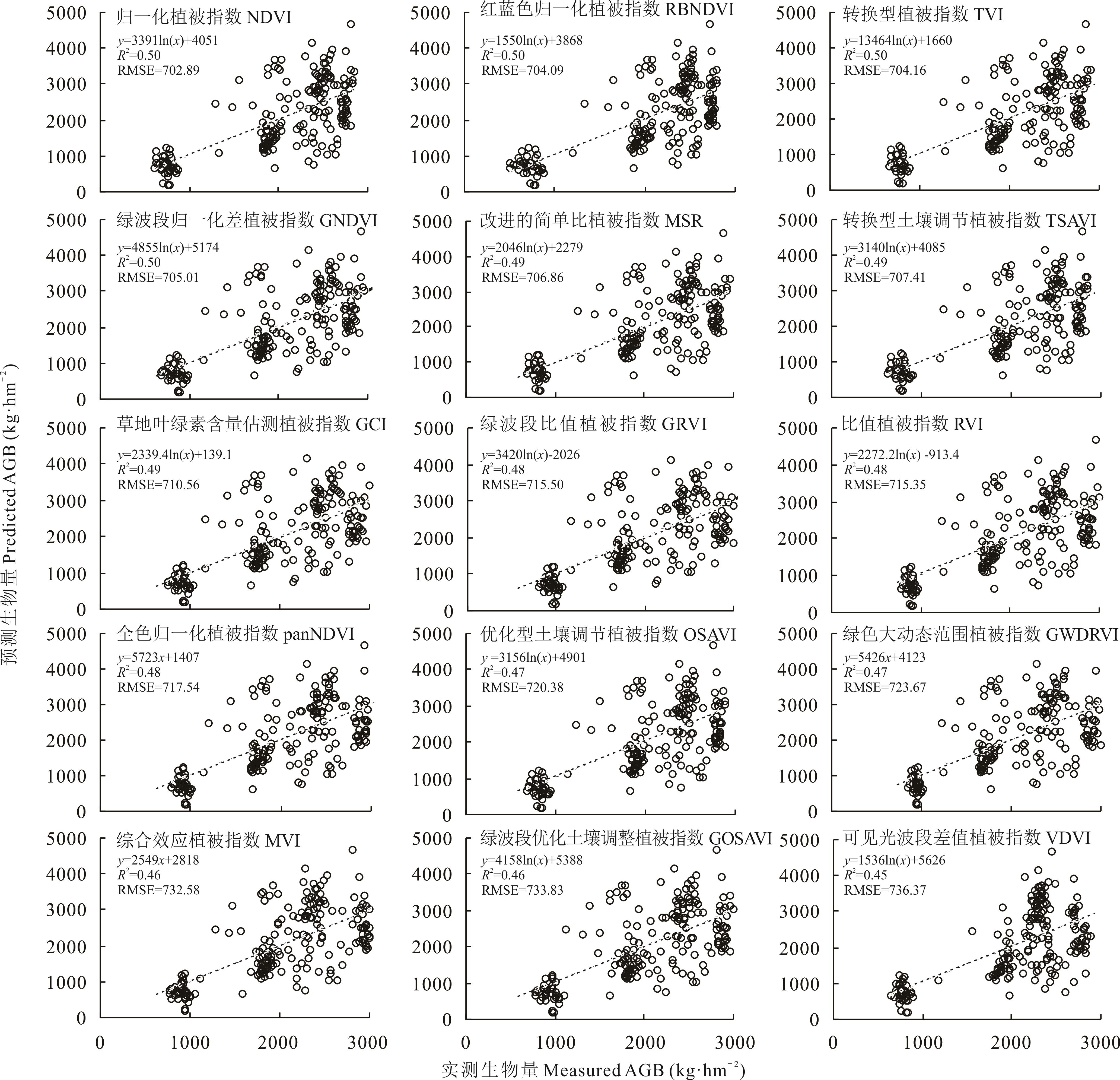
Fig.2 Relationship between predicted value and measured value of single-factor vegetation indexes regression model (n=199)

Fig.3 Relationship between predicted value and measured value of RF model

Fig.4 LASSO results
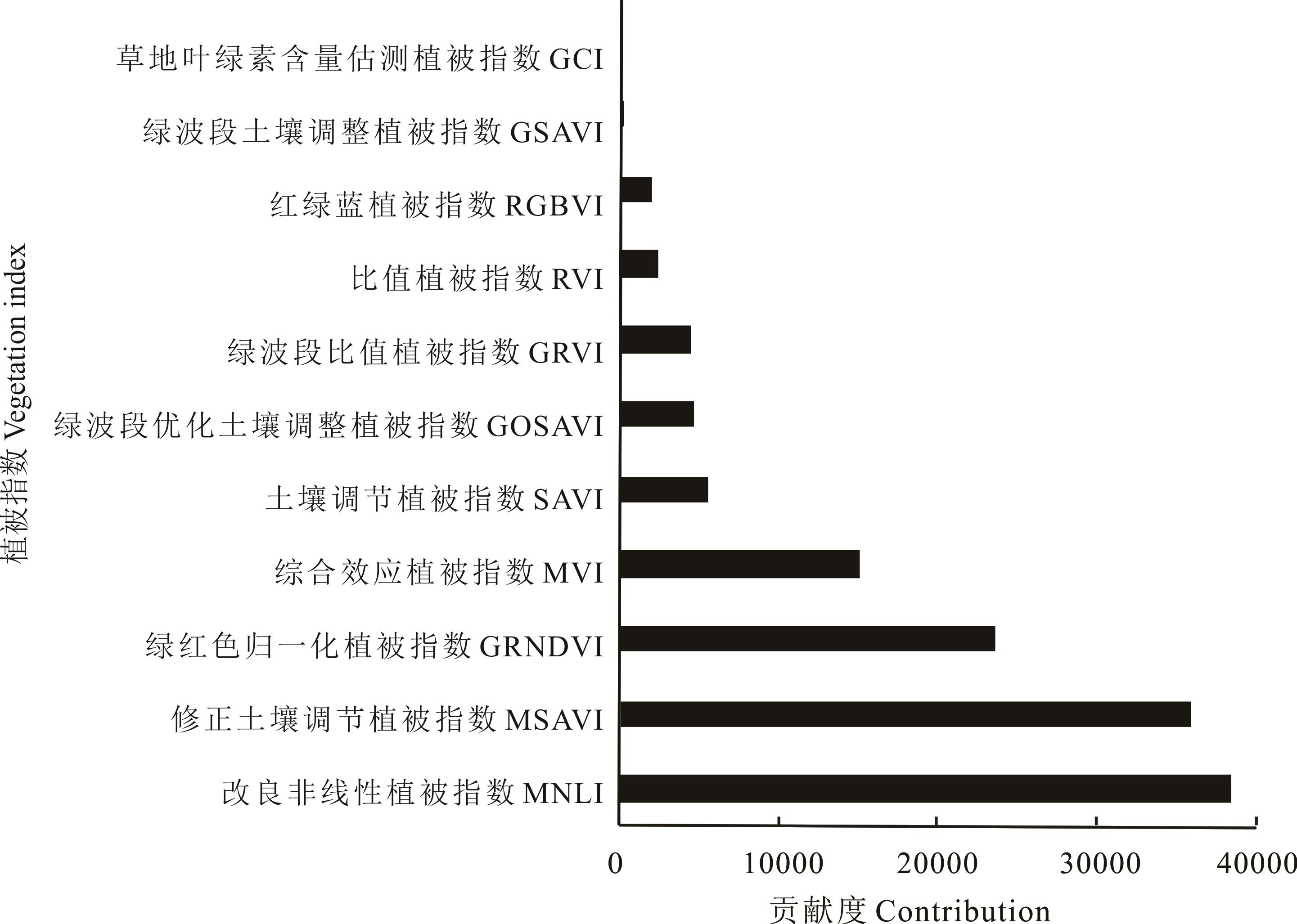
Fig.5 The importance of screened vegetation indexes

Fig.6 Spatial distribution of AGB of natural grassland in 2019 (a), 2020 (b) and 2021 (c) in Menyuan County
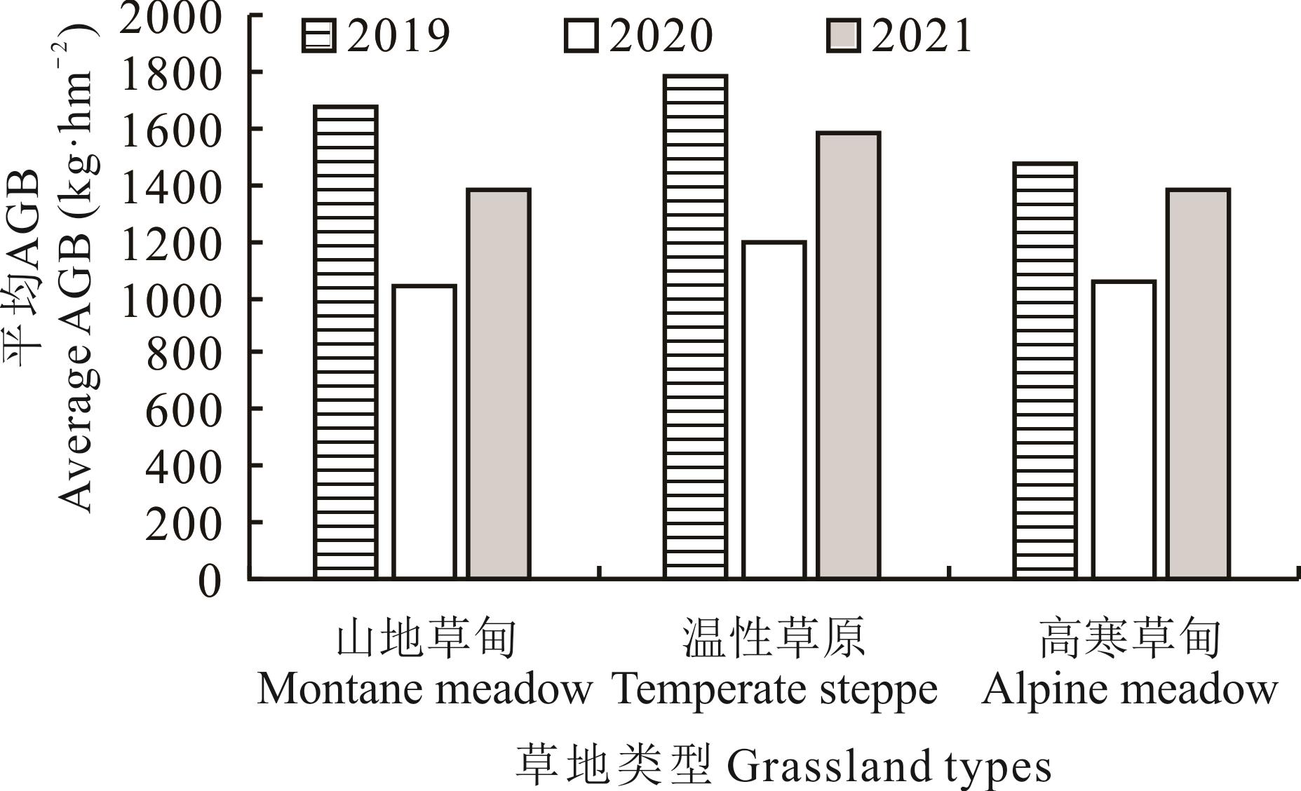
Fig.7 Average aboveground biomass of three main grassland types in Menyuan County
| 1 | Tsuyoshi A, Kensuke K. Grassland degradation in China: Methods of monitoring, management and restoration. Japanese Society of Grassland Science, 2013, 53(1): 1-17. |
| 2 | Hu X B. Correlation analysis between pasture spectrum and forage yield. Grass-Feeding Livestock, 1996(4): 43-47. |
| 胡新博. 草地光谱与牧草产量的相关分析. 草食家畜, 1996(4): 43-47. | |
| 3 | Shang Z, Long R. Formation causes and recovery of the “Black Soil Type” degraded alpine grassland in Qinghai-Tibetan Plateau. Frontiers of Agriculture in China, 2007, 1(2): 197-202. |
| 4 | Yang P W, Fu G, Li Y L, et al. Aboveground biomass assessment in the Northern Tibet Plateau using ground-level remotely-sensed data. Pratacultural Science, 2014, 31(7): 1211-1217. |
| 杨鹏万, 付刚, 李云龙, 等. 多光谱相机估算藏北高寒草甸地上生物量. 草业科学, 2014, 31(7): 1211-1217. | |
| 5 | Ali I, Cawkwell F, Dwyer E, et al. Modeling managed grassland biomass estimation by using multitemporal remote sensing data-A machine learning approach. IEEE Journal of Selected Topics in Applied Earth Observations and Remote Sensing, 2016, 10(7): 3254-3264. |
| 6 | Yao X C, Qu T T, Chang W J, et al. Estimation of grassland biomass using MODIS data and plant community characteristics. Chinese Journal of Eco-Agriculture, 2017, 25(4): 530-541. |
| 姚兴成, 曲恬甜, 常文静, 等. 基于MODIS数据和植被特征估算草地生物量. 中国生态农业学报, 2017, 25(4): 530-541. | |
| 7 | Yu H, Wu Y F, Jin Y, et al. An approach for monitoring the aboveground biomass of grassland in arid areas based on MODIS SWIR bands. Remote Sensing Technology and Application, 2017, 32(3): 524-530. |
| 于惠, 吴玉锋, 金毅, 等. 基于MODIS SWIR数据的干旱区草地地上生物量反演及时空变化研究. 遥感技术与应用, 2017, 32(3): 524-530. | |
| 8 | Feng Q S, Gao X H, Huang X D, et al. Remote sensing dynamic monitoring of grassland growth in Qinghai Tibet Plateau from 2001 to 2010. Journal of Lanzhou University (Natural Sciences), 2011, 47(4): 75-81, 90. |
| 冯琦胜, 高新华, 黄晓东, 等. 2001-2010年青藏高原草地生长状况遥感动态监测. 兰州大学学报(自然科学版), 2011, 47(4): 75-81, 90. | |
| 9 | Xu T, Cao L, She G H. Feature extraction and forest biomass estimation based on Landsat 8 OLI. Remote Sensing Technology and Application, 2015, 30(2): 226-234. |
| 徐婷, 曹林, 佘光辉. 基于Landsat 8 OLI的特征变量优化提取及森林生物量反演. 遥感技术与应用, 2015, 30(2): 226-234. | |
| 10 | Li B, Qin M Z, Zhang P Y. Comparative study on NDVI of Landsat 8 remote sensing image. Journal of Henan University (Natural Science), 2017, 47(2): 155-161. |
| 李斌, 秦明周, 张鹏岩. Landsat 8遥感影像NDVI的对比研究. 河南大学学报(自然科学版), 2017, 47(2): 155-161. | |
| 11 | Li C, Wulf H, Schmid B, et al. Estimating plant traits of alpine grasslands on the Qinghai-Tibetan plateau using remote sensing. IEEE Journal of Selected Topics in Applied Earth Observations and Remote Sensing, 2018, 11(7): 2263-2275. |
| 12 | Wu R H. Estimation of aboveground biomass in Zhenglan Banner grassland by remote sensing. Hohhot: Inner Mongolia Normal University, 2018. |
| 乌如汗. 正蓝旗草地地上生物量遥感估算研究. 呼和浩特: 内蒙古师范大学, 2018. | |
| 13 | Zhou M, Han X X, Zheng H B, et al. Remote sensing estimation of cotton biomass based on parametric and nonparametric methods by using hyperspectral reflectance. Scientia Agricultura Sinica, 2021, 54(20): 4299-4311. |
| 周萌, 韩晓旭, 郑恒彪, 等. 基于参数化和非参数化法的棉花生物量高光谱遥感估算. 中国农业科学, 2021, 54(20): 4299-4311. | |
| 14 | Yang J Y, Zhang S, Bai Y, et al. SPEI simulation for monitoring drought based machine learning integrating multi-source remote sensing data in Shandong. Chinese Journal of Agrometeorology, 2021, 42(3): 230-242. |
| 杨晋云, 张莎, 白雲, 等. 基于机器学习融合多源遥感数据模拟SPEI监测山东干旱. 中国农业气象, 2021, 42(3): 230-242. | |
| 15 | Xiao F. Analysis on main plant community composition of natural grassland in Menyuan County, Qinghai Province. Prataculture and Animal Husbandry, 2007(9): 10-12. |
| 肖锋. 青海省门源县天然草地主要植物群落组成分析. 草业与畜牧, 2007(9): 10-12. | |
| 16 | Liu J, Feng Q S, Liang T G, et al. Estimating the forage neutral detergent fiber content of alpine grassland in the Tibetan Plateau using hyperspectral data and machine learning algorithms. IEEE Transactions on Geoscience and Remote Sensing, 2021, doi: 10.1109/TGRS.2021.3105482. |
| 17 | Zhang L J, Tan B J. Variable selection method based on trace Lasso model. Systems Engineering, 2018, 36(12): 127-134. |
| 张立军, 谭冰洁. 基于迹Lasso模型的变量筛选方法. 系统工程, 2018, 36(12): 127-134. | |
| 18 | Zhang X X, Wang H, Tian S S, et al. Lasso-based independent variable selection in high-dimensional data regression analysis. Chinese Journal of Health Statistics, 2013, 30(6): 922-926. |
| 张秀秀, 王慧, 田双双, 等. 高维数据回归分析中基于LASSO的自变量选择. 中国卫生统计, 2013, 30(6): 922-926. | |
| 19 | Li G H, Li J Q, Zhang L, et al. Feature selection method based on ant colony optimization and random forest. Computer Science, 2019, 46(Supple2): 212-215. |
| 李光华, 李俊清, 张亮, 等. 一种融合蚁群算法和随机森林的特征选择方法. 计算机科学, 2019, 46(增刊2): 212-215. | |
| 20 | Chen Y P, Yun W J, Zhou X, et al. Classification and extraction of land use information in hilly area based on MESMA and RF classifier. Transactions of the Chinese Society for Agricultural Machinery, 2017, 48(7): 136-144. |
| 陈元鹏, 郧文聚, 周旭, 等. 基于MESMA和RF的山丘区土地利用信息分类提取. 农业机械学报, 2017, 48(7): 136-144. | |
| 21 | Hou M J, Yin J P, Ge J, et al. Land cover remote sensing classification method of alpine wetland region based on random forest algorithm. Transactions of the Chinese Society for Agricultural Machinery, 2020, 51(7): 220-227. |
| 侯蒙京, 殷建鹏, 葛静, 等. 基于随机森林的高寒湿地地区土地覆盖遥感分类方法. 农业机械学报, 2020, 51(7): 220-227. | |
| 22 | Meng B P, Chen S Y, Cui X, et al. The accuracy of grassland vegetation biomass estimated model based on multi-source remote sensing data——As a case of experimental area in Sangke grassland in Xiahe County. Pratacultural Science, 2015, 32(11): 1730-1739. |
| 孟宝平, 陈思宇, 崔霞, 等. 基于多源遥感数据的高寒草地生物量反演模型精度——以夏河县桑科草原试验区为例. 草业科学, 2015, 32(11): 1730-1739. | |
| 23 | He Y J, Pan X B, Pei Z Y, et al. Estimation of LAI and yield of sugarcane based on SPOT remote sensing data. Transactions of the Chinese Society for Agricultural Machinery, 2013, 44(5): 226-231. |
| 何亚娟, 潘学标, 裴志远, 等. 基于SPOT遥感数据的甘蔗叶面积指数反演和产量估算. 农业机械学报, 2013, 44(5): 226-231. | |
| 24 | Wu C Y, Niu Z. Improvement of linearity between hyperspectral vegetation indices and chlorophyll content, leaf area index based on radiative transfer models. Chinese Bulletin of Botany, 2008, 25(6): 714-721. |
| 吴朝阳, 牛铮. 基于辐射传输模型的高光谱植被指数与叶绿素浓度及叶面积指数的线性关系改进. 植物学报, 2008, 25(6): 714-721. | |
| 25 | Li S Y, Li X B, Ying G, et al. Vegetation indexes-biomass models for typical semi-arid steppe——A case study for Xilinhot in Northern China. Journal of Plant Ecology, 2007, 31(1): 23-31. |
| 李素英, 李晓兵, 莺歌, 等. 基于植被指数的典型草原区生物量模型——以内蒙古锡林浩特市为例.植物生态学报, 2007, 31(1): 23-31. | |
| 26 | Ge J, Meng B P, Yang S X, et al. Monitoring of above-ground biomass in alpine grassland based on agricultural digital camera and MODIS remote sensing data: A case study in the Yellow River headwater region. Acta Prataculturae Sinica, 2017, 26(7): 23-34. |
| 葛静, 孟宝平, 杨淑霞, 等. 基于ADC和MODIS遥感数据的高寒草地地上生物量监测研究——以黄河源区为例. 草业学报, 2017, 26(7): 23-34. | |
| 27 | Ma C, Shi Y, Li M H, et al. Research of grassland biomass model based on NDVI in loess hilly and gully region: A case study of Pengyang County, Ningxia. Ningxia Engineering Technology, 2017, 16(1): 19-23. |
| 马超, 石云, 李梦华, 等. 基于NDVI的黄土丘陵沟壑区草地生物量模型研究——以宁夏彭阳县为例. 宁夏工程技术, 2017, 16(1): 19-23. | |
| 28 | Gao Z H, Wei H D, Ding F. Methods for subtracting vegetation information using vegetation index(VI)from TM images. Journal of Arid Land Resources and Environment, 1998, 12(3): 98-104. |
| 高志海, 魏怀东, 丁峰. TM影像VI提取植被信息技术研究. 干旱区资源与环境, 1998, 12(3): 98-104. | |
| 29 | Qu C P, Guan D X, Wang A Z, et al. Comparison of grassland biomass estimation models based on MODIS data. Chinese Journal of Ecology, 2008, 27(11): 2028-2032. |
| 渠翠平, 关德新, 王安志, 等. 基于MODIS数据的草地生物量估算模型比较. 生态学杂志, 2008, 27(11): 2028-2032. | |
| 30 | Wang F M, Huang J F, Tang Y L, et al. New vegetation index and its application in estimating leaf area index of rice. Rice Science, 2007, 14(3): 195-203. |
| 31 | Mutanga O, Adam E, Cho M A. High density biomass estimation for wetland vegetation using WorldView-2 imagery and random forest regression algorithm. International Journal of Applied Earth Observation and Geoinformation, 2012, 18: 399-406. |
| 32 | Wang J G, Lv X D, Yao G P, et al. Estimation of fresh forage yield of mixed sowing pastures of alfalfa and smooth-brome with hyperspectral remote sensing. Chinese Journal of Grassland, 2013, 35(1): 35-41. |
| 王建光, 吕小东, 姚贵平, 等. 苜蓿和无芒雀麦混播草地高光谱遥感估产研究. 中国草地学报, 2013, 35(1): 35-41. | |
| 33 | Zhang Z J, Li A N, Bian J H, et al. Estimating aboveground biomass of grassland in Zoige by visible vegetation index derived from unmanned aerial vehicle images. Remote Sensing Technology and Application, 2016, 31(1): 51-62. |
| 张正健, 李爱农, 边金虎, 等. 基于无人机影像可见光植被指数的若尔盖草地地上生物量估算研究. 遥感技术与应用, 2016, 31(1): 51-62. | |
| 34 | Gong P, Pu R, Biging G S, et al. Estimation of forest leaf area index using vegetation indices derived from hyperion hyperspectral data. IEEE Transactions on Geoscience and Remote Sensing, 2003, 41(6): 1355-1362. |
| 35 | Guo C F, Chen Z W, Zhang Z G. Research of remote sensing estimation of forage above-ground biomass based on optimal model selection. Acta Agrestia Sinica, 2021, 29(5): 946-955. |
| 郭超凡, 陈泽威, 张志高. 基于最优模型选择的牧草地上生物量遥感估算研究. 草地学报, 2021, 29(5): 946-955. | |
| 36 | Zhou J H, Wang Z Z, Liao S X, et al. Remote sensing estimation of forest aboveground biomass in Potatso National Park using GF-1 images. Transactions of the Chinese Society of Agricultural Engineering, 2021, 37(4): 216-223. |
| 周俊宏, 王子芝, 廖声熙, 等. 基于GF-1影像的普达措国家公园森林地上生物量遥感估算. 农业工程学报, 2021, 37(4): 216-223. | |
| 37 | Chen Y Y. Exploring bamboo forest aboveground biomass estimation using Sentinel-2 data. Hangzhou: Zhejiang A&F University, 2019. |
| 陈瑜云. 基于Sentinel-2影像数据的毛竹林生物量估测. 杭州: 浙江农林大学, 2019. | |
| 38 | Gao H Y, Hou M J, Ge J, et al. Hyperspectral estimation of aboveground biomass of alpine grassland based on random forest algorithm. Acta Agrestia Sinica, 2021, 29(8): 1757-1768. |
| 高宏元, 侯蒙京, 葛静, 等. 基于随机森林的高寒草地地上生物量高光谱估算. 草地学报, 2021, 29(8): 1757-1768. | |
| 39 | Liang T G, Yang S X, Feng Q S, et al. Multi-factor modeling of above-ground biomass in alpine grassland: A case study in the Three-River Headwaters Region, China. Remote Sensing of Environment, 2016, 186: 164-172. |
| 40 | Meng B P. Estimation grassland above ground biomass based on UAV technology and machine learning methods in alpine grassland, Gannan Region. Lanzhou: Lanzhou University, 2018. |
| 孟宝平. 基于UAV和机器学习方法的甘南地区高寒草地地上生物量遥感估测研究. 兰州: 兰州大学, 2018. |
| [1] | Jiang-long SHEN, Ji-jun CHEN, Abuduwali IMAM, Kun YANG, Ya-ting GUO, Jiang-hua ZHENG. The relationship between attack by Prosodes dilaticollis and desert grassland changes in Xinjiang: A case study of southern mountain grassland in Changji [J]. Acta Prataculturae Sinica, 2022, 31(6): 163-177. |
| [2] | Jia-li LIU, Jian-rong FAN, Xi-yu ZHANG, Chao YANG, Fu-bao XU, Xiao-xue ZHANG, Bo LIANG. Remote sensing estimation of vegetation cover in alpine grassland in the growing and non-growing seasons [J]. Acta Prataculturae Sinica, 2021, 30(9): 15-26. |
| [3] | Yi-ran ZHANG, Ting-xi LIU, Xin TONG, Li-min DUAN, Yu-chen WU. Hyperspectral remote sensing inversion of meadow aboveground biomass based on an XGBoost algorithm [J]. Acta Prataculturae Sinica, 2021, 30(4): 1-12. |
| [4] | Jia-meng DU, Gang BAO, Si-qin TONG, Xiao-jun HUANG, Wendurina, Meili, Yu-hai BAO. Variations in vegetation cover and its relationship with climate change and human activities in Mongolia during the period 1982-2015 [J]. Acta Prataculturae Sinica, 2021, 30(2): 1-13. |
| [5] | GE Jing, MENG Bao-Ping, YANG Shu-Xia, GAO Jin-Long, YIN Jian-Peng, ZHANG Ren-Ping, FENG Qi-Sheng, LIANG Tian-Gang. Monitoring of above-ground biomass in alpine grassland based on agricultural digital camera and MODIS remote sensing data: A case study in the Yellow River Headwater Region [J]. Acta Prataculturae Sinica, 2017, 26(7): 23-34. |
| [6] | WANG Lu, DING Jian-Li. Vegetation index feature change and its influencing factors and spatial-temporal process analysis of desert grassland in the Ebinur Lake Nature Reserve, Xinjiang [J]. Acta Prataculturae Sinica, 2015, 24(5): 4-11. |
| [7] |
CHEN Meng-die, HUANG Xiao-dong, HOU Xiu-min, FENG Qi-sheng, YU Hui, GUO Zheng-gang, LIANG Tian-gang.
Dynamic monitoring of biomass and vegetation coverage in rodent damaged grassland regions of Qinghai Province, China [J]. Acta Prataculturae Sinica, 2013, 22(4): 247-256. |
| [8] |
QIAN Yu-rong, YANG Feng, YU Jiong, JIA Zhen-hong, LI Jian-long, Palidan Tuerxun.
Vegetation index feature and spatial-temporal process analysis of desert grassland in the Fukang area of Xinjiang [J]. Acta Prataculturae Sinica, 2013, 22(3): 25-. |
| [9] | QIAN Yu-rong, YU Jiong, JIA Zhen-hong, YANG Feng, Palidan Tuerxun. Extraction and analysis of hyper-spectral data from typical desert grassland in Xinjiang [J]. Acta Prataculturae Sinica, 2013, 22(1): 157-166. |
| [10] | YANG Hong-fei, LI Jian-long, MU Shao-jie, YANG Qi, HU Xiao-xiao, JIN Guo-ping, ZHAO Wan-yu. Analysis of hyperspectral reflectance characteristics of three main grassland types in Xinjiang [J]. Acta Prataculturae Sinica, 2012, 21(6): 258-266. |
| [11] | HUA Li-min. Study the change of NDVI and climate factors and carrying capacity and their correlation in Maqu County, Gansu [J]. Acta Prataculturae Sinica, 2012, 21(4): 224-235. |
| [12] | ZHANG Yan-nan, NIU Jan-ming, ZHANG Qing, YANG Yan, DONG Jian-jun. A discussion on applications of vegetation index for estimating aboveground biomass of typical steppe [J]. Acta Prataculturae Sinica, 2012, 21(1): 229-238. |
| [13] | YANG Hong-li, CHEN Gong, WU Jian-fu. Plant nitrogen content of annual ryegrass and spectral reflectance response to nitrogen application level [J]. Acta Prataculturae Sinica, 2011, 20(3): 239-244. |
| [14] | WANG Ying, XIA Wen-tao, LIANG Tian-gang, WANG Chao. Spatial and temporal dynamic changes of net primary product basedon MODIS vegetation index in Gannan grassland [J]. Acta Prataculturae Sinica, 2010, 19(1): 201-210. |
| [15] | LIANG Tian-gang, CUI Xia, FENG Qi-sheng, WANG Ying, XIA Wen-tao. Remotely sensed dynamics monitoring of grassland aboveground biomass and carrying capacityduring 2001-2008 in Gannan pastoral area [J]. Acta Prataculturae Sinica, 2009, 18(6): 12-22. |
| Viewed | ||||||
|
Full text |
|
|||||
|
Abstract |
|
|||||