
ISSN 1004-5759 CN 62-1105/S
Acta Prataculturae Sinica ›› 2023, Vol. 32 ›› Issue (8): 28-39.DOI: 10.11686/cyxb2022385
Previous Articles Next Articles
Fang LI1( ), Guang-jun WANG1(), Hai-bo DU2, Meng LI1, Si-hai LIANG3, Hong-ming PENG4,5
Received:2022-09-27
Revised:2022-12-09
Online:2023-08-20
Published:2023-06-16
Contact:
Guang-jun WANG
Fang LI, Guang-jun WANG, Hai-bo DU, Meng LI, Si-hai LIANG, Hong-ming PENG. Integrating MODIS and Landsat data to reconstruct the Landsat NDVI of a typical region in the Qinghai Lake Basin and changes in the intra-annual NDVI maximum[J]. Acta Prataculturae Sinica, 2023, 32(8): 28-39.

Fig.1 Location of the study area and vegetation distribution
年份 Year | 参与融合的左右影像(MODIS日) Left and right images involved in fusion (MODIS day) | 预测目标Landsat影像日期 Predict the target Landsat image data |
|---|---|---|
| 2001 | 152(06-02), 169(06-18) | 06-10 |
| 185(07-04), 233(08-21) | 08-02 | |
| 240(08-28), 281(10-08) | 09-04 | |
| 2005 | 164(06-13), 180(06-29) | 06-25 |
| 196(07-15), 235(08-23) | 07-21 | |
| 251(09-08), 260(09-17) | 09-13 | |
| 2009 | 175(06-24), 198(07-17) | 06-28 |
| 207(07-26), 223(08-11) | 08-05 | |
| 239(08-27), 271(09-28) | 09-22 | |
| 2011 | 165(06-14), 188(07-07) | 06-30 |
| 197(07-16), 213(08-01) | 07-24 | |
| 220(08-08), 236(08-24) | 08-16 | |
| 252(09-09), 277(10-04) | 09-25 | |
| 2014 | 157(06-06), 196(07-15) | 07-04 |
| 205(07-24), 260(09-17) | 07-31 | |
| 2016 | 186(07-04), 202(07-20) | 07-15 |
| 211(07-29), 250(09-06) | 08-07 | |
| 259(09-15), 275(10-01) | 09-20 | |
| 2019 | 162(06-11), 203(07-22) | 07-05 |
| 226(08-14), 258(09-15) | 08-30 | |
| 274(10-01), 290(10-17) | 10-09 | |
| 2020 | 181(06-29), 222(08-09) | 07-25 |
| 238(08-25), 254(09-10) | 09-04 | |
| 261(09-17), 277(10-03) | 09-23 |
Table 1 Reference image and prediction image information
年份 Year | 参与融合的左右影像(MODIS日) Left and right images involved in fusion (MODIS day) | 预测目标Landsat影像日期 Predict the target Landsat image data |
|---|---|---|
| 2001 | 152(06-02), 169(06-18) | 06-10 |
| 185(07-04), 233(08-21) | 08-02 | |
| 240(08-28), 281(10-08) | 09-04 | |
| 2005 | 164(06-13), 180(06-29) | 06-25 |
| 196(07-15), 235(08-23) | 07-21 | |
| 251(09-08), 260(09-17) | 09-13 | |
| 2009 | 175(06-24), 198(07-17) | 06-28 |
| 207(07-26), 223(08-11) | 08-05 | |
| 239(08-27), 271(09-28) | 09-22 | |
| 2011 | 165(06-14), 188(07-07) | 06-30 |
| 197(07-16), 213(08-01) | 07-24 | |
| 220(08-08), 236(08-24) | 08-16 | |
| 252(09-09), 277(10-04) | 09-25 | |
| 2014 | 157(06-06), 196(07-15) | 07-04 |
| 205(07-24), 260(09-17) | 07-31 | |
| 2016 | 186(07-04), 202(07-20) | 07-15 |
| 211(07-29), 250(09-06) | 08-07 | |
| 259(09-15), 275(10-01) | 09-20 | |
| 2019 | 162(06-11), 203(07-22) | 07-05 |
| 226(08-14), 258(09-15) | 08-30 | |
| 274(10-01), 290(10-17) | 10-09 | |
| 2020 | 181(06-29), 222(08-09) | 07-25 |
| 238(08-25), 254(09-10) | 09-04 | |
| 261(09-17), 277(10-03) | 09-23 |
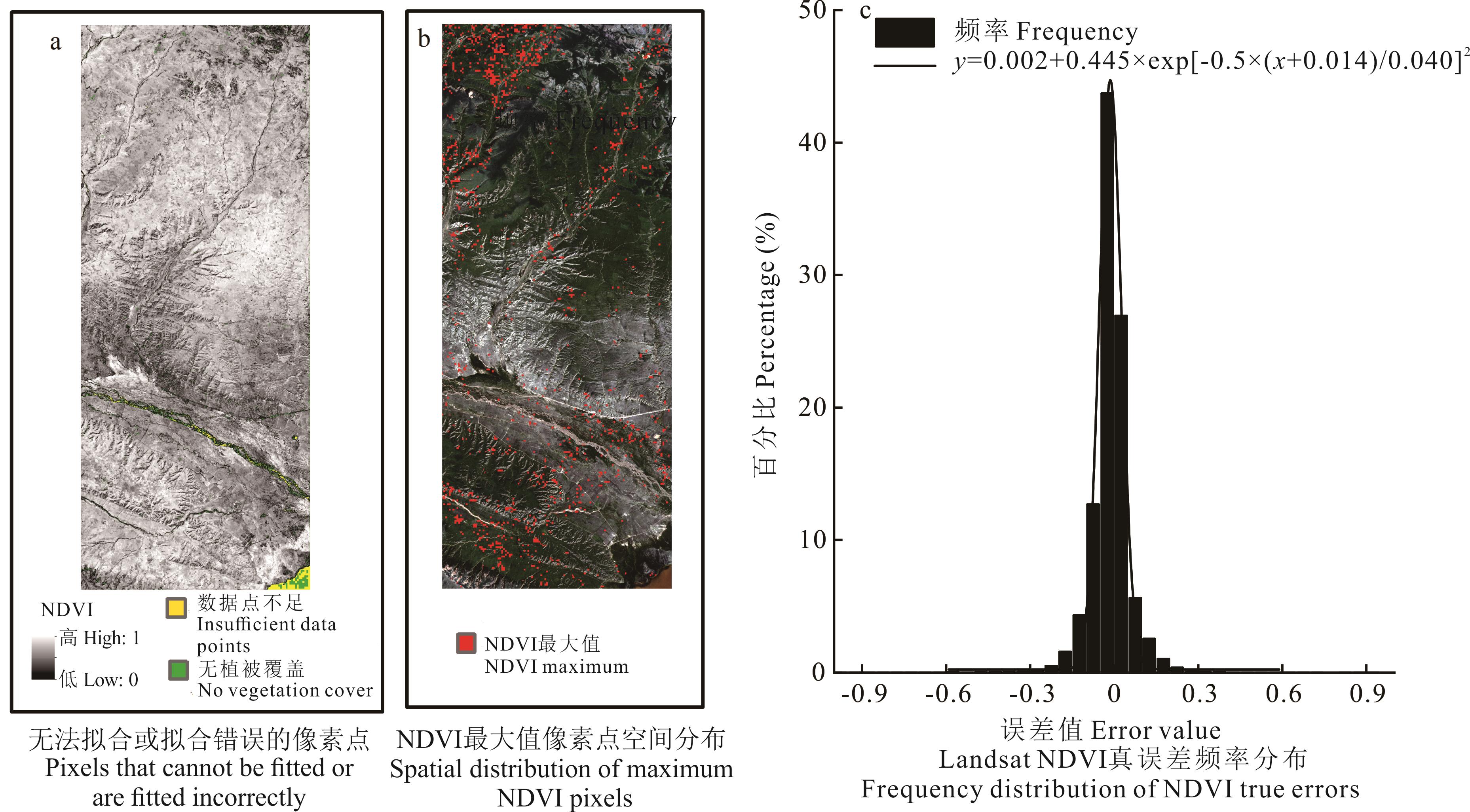
Fig.2 Accuracy evaluation of Logistic model fitting
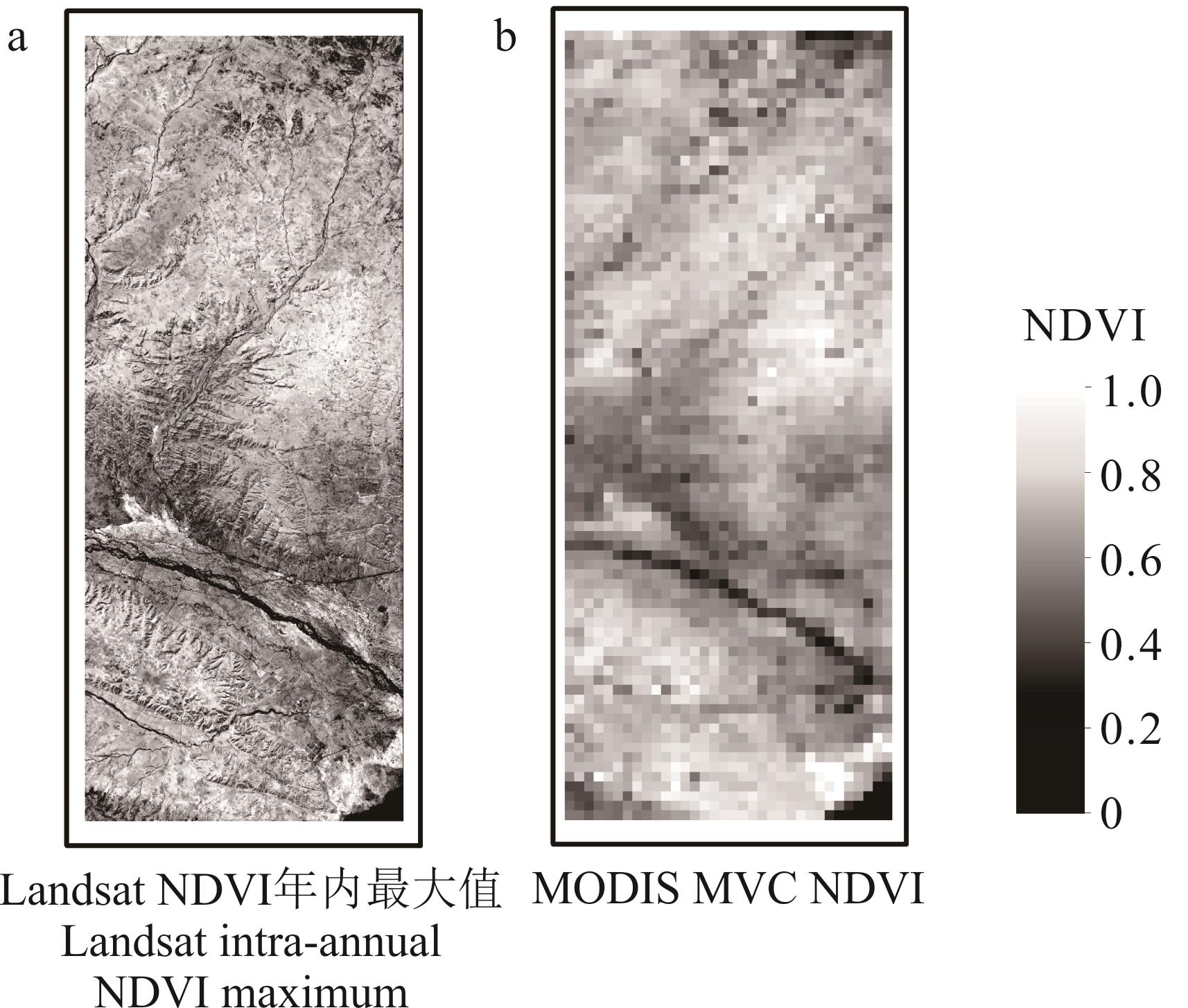
Fig.3 Comparison of Landsat fitting results with MODIS MVC NDVI results in 2005

Fig.4 Comparison of NDVI difference between 2020 and 2005
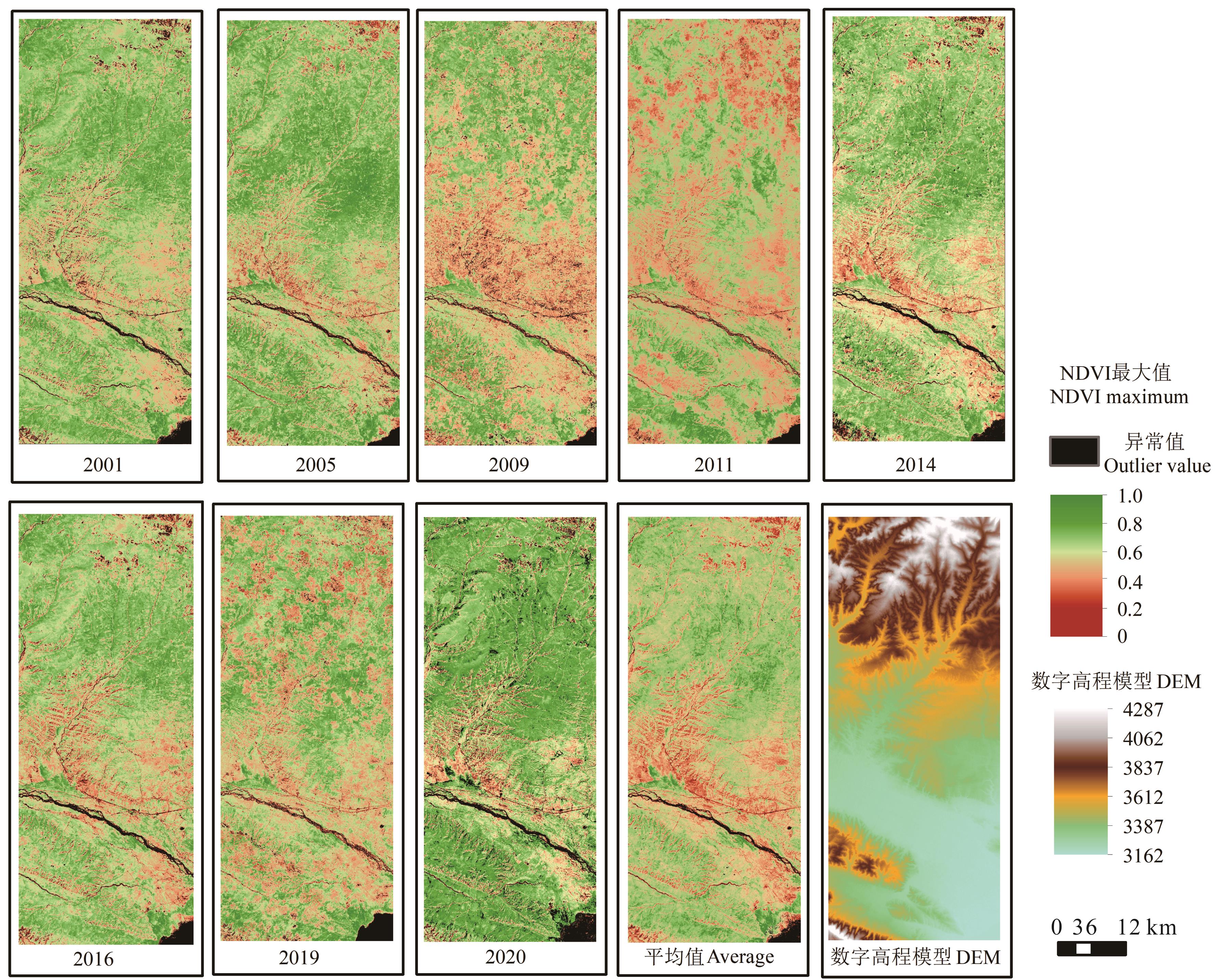
Fig.5 DEM and spatial distribution of Landsat intra-annual NDVI maximum in the study area from 2001 to 2020
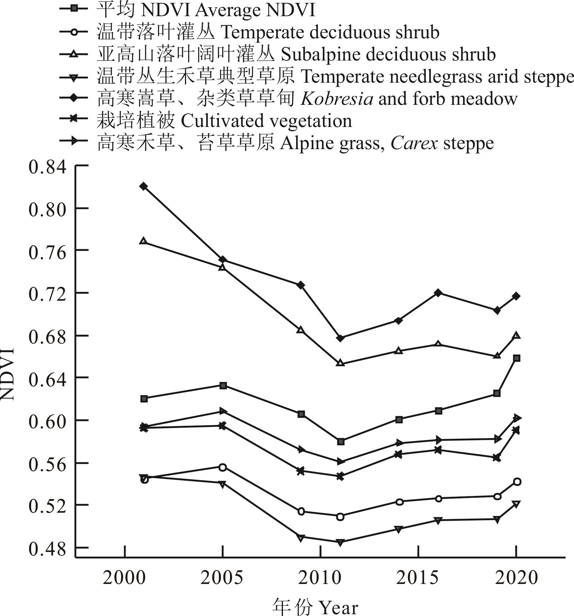
Fig.6 Characteristics of variation of intra-annual NDVI maximum from 2001 to 2020
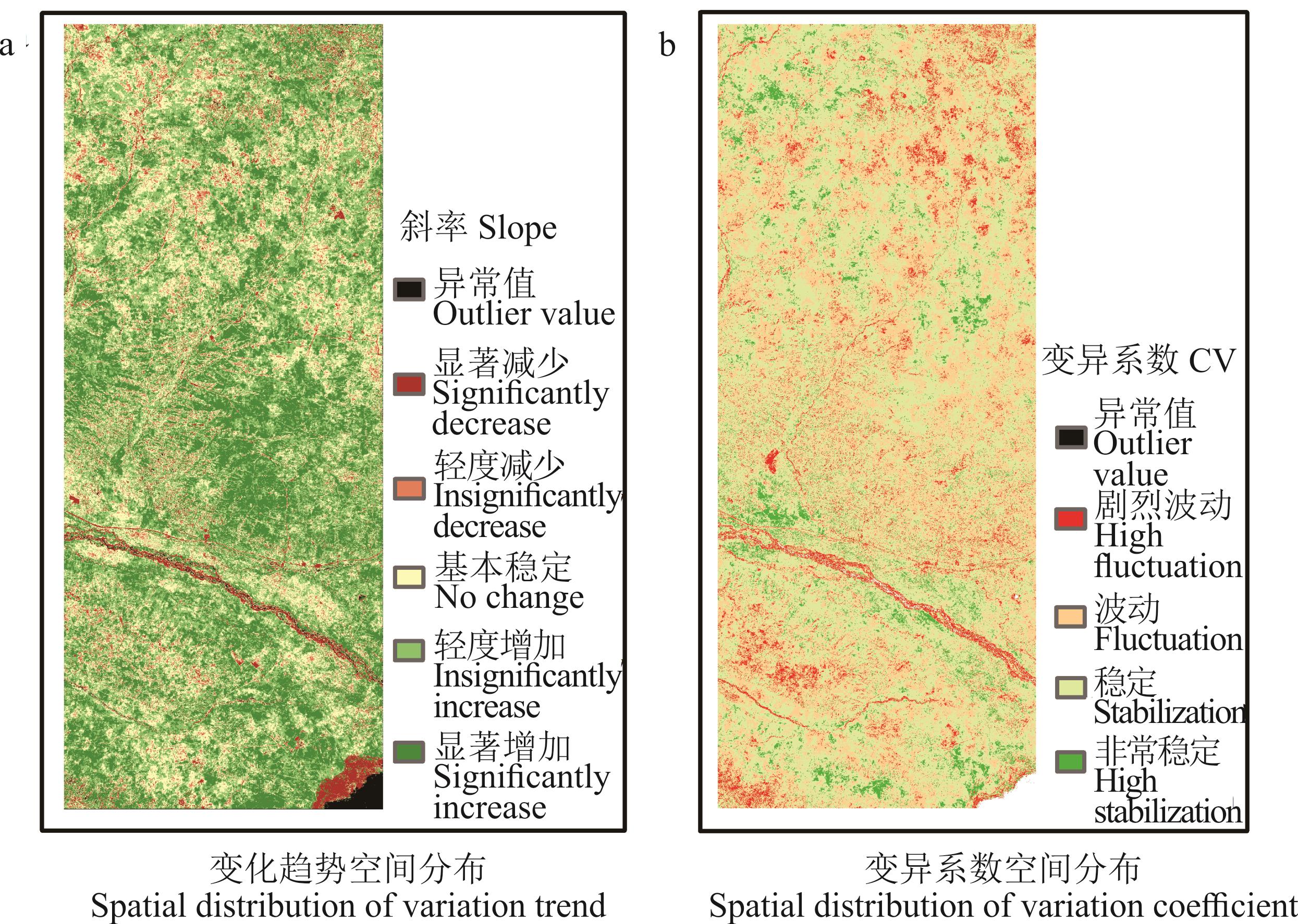
Fig.7 Spatial distribution of the maximum value change trend and coefficient of variation of NDVI from 2001 to 2020
| 斜率Slope | 变化趋势等级Grade of variation trend | 占总面积百分比Percentage of total area (%) |
|---|---|---|
| Slope≤-0.0005 | 显著减少Significant decrease | |
| -0.0005<Slope≤-0.0002 | 轻度减少Insignificant decrease | |
| -0.0002<Slope≤0.0002 | 基本稳定No change | 26.97 |
| 0.0002<Slope≤0.0005 | 轻度增加Insignificant increase | 36.67 |
| Slope>0.0005 | 显著增加Significant increase | 28.33 |
Table 2 Grading of change trend and area proportion in the study area
| 斜率Slope | 变化趋势等级Grade of variation trend | 占总面积百分比Percentage of total area (%) |
|---|---|---|
| Slope≤-0.0005 | 显著减少Significant decrease | |
| -0.0005<Slope≤-0.0002 | 轻度减少Insignificant decrease | |
| -0.0002<Slope≤0.0002 | 基本稳定No change | 26.97 |
| 0.0002<Slope≤0.0005 | 轻度增加Insignificant increase | 36.67 |
| Slope>0.0005 | 显著增加Significant increase | 28.33 |
| 变异系数CV | 变异程度 Degree of variation | 占总面积百分比Percentage of total area (%) |
|---|---|---|
| 0<CV≤0.1 | 非常稳定High stabilization | |
| 0.1<CV≤0.2 | 稳定Stabilization | 53.42 |
| 0.2<CV≤0.3 | 波动Fluctuation | 32.70 |
| CV>0.3 | 剧烈波动High fluctuation |
Table 3 Coefficient of variation (CV) classification and area proportion in the study area
| 变异系数CV | 变异程度 Degree of variation | 占总面积百分比Percentage of total area (%) |
|---|---|---|
| 0<CV≤0.1 | 非常稳定High stabilization | |
| 0.1<CV≤0.2 | 稳定Stabilization | 53.42 |
| 0.2<CV≤0.3 | 波动Fluctuation | 32.70 |
| CV>0.3 | 剧烈波动High fluctuation |
| 1 | Zhang H, Zhao Y, Zhu J K. Thriving under stress: How plants balance growth and the stress response. Developmental Cell, 2020, 55(5): 529-543. |
| 2 | Cheng M. Spatial-temporal variations of vegetation phenology and its effect on water use efficiency in the Tibetan Plateau. Nanjing: Nanjing University, 2019. |
| 程敏. 基于遥感监测的青藏高原植被物候及其对水分利用效率影响的时空变化特征. 南京: 南京大学, 2019. | |
| 3 | Niu B, Li X J, Li F Q, et al. Vegetation dynamics and its linkage with climatic and anthropogenic factors in the Dawen River Watershed of China from 1999 through 2018. Environmental Science and Pollution Research International, 2021, 28(38): 52887-52900. |
| 4 | White M A, Beurs K M D, Didan K, et al. Intercomparison, interpretation, and assessment of spring phenology in North America estimated from remote sensing for 1982-2006. Global Change Biology, 2009, 15(10): 2335-2359. |
| 5 | Zeng L, Wardlow B D, Xiang D X, et al. A review of vegetation phenological metrics extraction using time-series, multispectral satellite data. Remote Sensing of Environment, 2020, 237: 111511. |
| 6 | Piao S L, Fang J Y. Seasonal changes in vegetation activity in response to climate changes in China between 1982 and 1999. Acta Geographica Sinica, 2003, 58(1): 119-125. |
| 朴世龙, 方精云. 1982-1999年我国陆地植被活动对气候变化响应的季节差异. 地理学报, 2003, 58(1): 119-125. | |
| 7 | Ramírez-Cuesta J M, Minacapilli M, Motisi A, et al. Characterization of the main land processes occurring in Europe (2000-2018) through a MODIS NDVI seasonal parameter-based procedure. Science of the Total Environment, 2021, 799: 149346. |
| 8 | Liu Y, Tian J Y, Liu R H, et al. Influences of climate change and human activities on NDVI changes in China. Remote Sensing, 2021, 13(21): 4326. |
| 9 | Yves J, José S. Introducing the time series change visualization and interpretation (TSCVI) method for the interpretation of global NDVI changes. International Journal of Applied Earth Observations and Geoinformation, 2021, 96: 102268. |
| 10 | Zhang X Y, Feng Y H, Zeng H, et al. Change of NDVI during growing season and its relationship with climate in North China and the adjacent areas from 1982 to 2014. Acta Scientiarum Naturalium Universitatis Pekinensis, 2021, 57(1): 153-161. |
| 张新悦, 冯禹昊, 曾辉, 等. 1982-2014年华北及周边地区生长季NDVI变化及其与气候的关系. 北京大学学报: 自然科学版, 2021, 57(1): 153-161. | |
| 11 | Taylor B, Conover D, Beck R. Detecting invasive amur honeysuckle in urban green spaces of Cincinnati, Ohio using Landsat-8 NDVI difference images. Ecological Restoration, 2020, 38(3): 139-144. |
| 12 | Weber D, Schaepman-Strub G, Ecker K. Predicting habitat quality of protected dry grasslands using Landsat NDVI phenology. Ecological Indicators, 2018, 91(1): 447-460. |
| 13 | Feng L, Chen S B, Han B B. Monitoring of maize waterlogging with multi-temporal GF-1 images. Science Technology and Engineering, 2020, 20(10): 3868-3873. |
| 冯琳, 陈圣波, 韩冰冰. 基于多时相高分一号影像的玉米涝灾监测. 科学技术与工程, 2020, 20(10): 3868-3873. | |
| 14 | Jia W H, Liu Y Y, Hu S G. Extraction of herbaceous wetland information from high resolution remote sensing image based on ResNet34. Journal of Geomatics, 2021, 46(S1): 97-99. |
| 贾文翰, 刘越岩, 胡守庚. 基于ResNet34的高分遥感影像草本湿地信息提取. 测绘地理信息, 2021, 46(S1): 97-99. | |
| 15 | Wu X F, Li G X, Pan X P, et al. Response of vegetation cover to temperature and precipitation in the source region of the Yellow River. Resources Science, 2015, 37(3): 512-521. |
| 吴喜芳, 李改欣, 潘学鹏, 等. 黄河源区植被覆盖度对气温和降水的响应研究. 资源科学, 2015, 37(3): 512-521. | |
| 16 | Kang Y, Li Z C, Tian H, et al. Trend of vegetation evaluation and its responses to climate change over the source region of the Yellow River. Climatic and Environmental Research, 2011, 16(4): 505-512. |
| 康悦, 李振朝, 田辉, 等. 黄河源区植被变化趋势及其对气候变化的响应过程研究. 气候与环境研究, 2011, 16(4): 505-512. | |
| 17 | Gu H L, Chen M. Comprehensive insights into spatial-temporal evolution patterns, dominant factors of NDVI from pixel scale, as a case of Shaanxi Province, China. International Journal of Environmental Research and Public Health, 2021, 18(19): 10053. |
| 18 | Sun R, Chen S H, Su H B. Spatiotemporal variations of NDVI of different land cover types on the Loess Plateau from 2000 to 2016. Progress in Geography, 2019, 38(8): 1248-1258. |
| 孙锐, 陈少辉, 苏红波. 2000-2016年黄土高原不同土地覆盖类型植被NDVI时空变化. 地理科学进展, 2019, 38(8): 1248-1258. | |
| 19 | Ren L Q, Dong G T, Gu J H, et al. Spatiotemporal distribution and driving force analysis of vegetation in the upper reaches of Heihe River. Research of Soil and Water Conservation, 2021, 28(4): 244-250. |
| 任立清, 董国涛, 谷佳贺, 等. 黑河上游植被时空分布及驱动力分析. 水土保持研究, 2021, 28(4): 244-250. | |
| 20 | Li J F, Li X B, Zhou Y. Spatiotemporal variation of NDVI and its affecting factors in Ulanqab City in growing season from 2000 to 2015. Arid Zone Research, 2019, 36(5): 1238-1249. |
| 李建飞, 李小兵, 周义. 2000-2015年乌兰察布市生长季NDVI时空变化及其影响因素. 干旱区研究, 2019, 36(5): 1238-1249. | |
| 21 | Nie T, Dong G T, Jiang X H, et al. Spatio-temporal variations and influencing factors of vegetation in Yulin. Ecology and Environmental Sciences, 2022, 31(1): 26-36. |
| 聂桐, 董国涛, 蒋晓辉, 等. 榆林地区植被时空分异特征及其影响因素研究. 生态环境学报, 2022, 31(1): 26-36. | |
| 22 | Jiao K W, Gao J B, Liu Z H. Precipitation drives the NDVI distribution on the Tibetan Plateau while high warming rates may intensify its ecological droughts. Remote Sensing, 2021, 13(7): 1305. |
| 23 | Dai Z J, Zhao X, Li G W, et al. Spatial-temporal variations in NDVI in vegetation-growing season in Qinghai based on GIMMS NDVI 3g.v1 in past 34 years. Pratacultural Science, 2018, 35(4): 713-725. |
| 代子俊, 赵霞, 李冠稳, 等. 基于GIMMS NDVI 3g.v1的近34年青海省植被生长季NDVI时空变化特征. 草业科学, 2018, 35(4): 713-725. | |
| 24 | Yang D, Yi G H, Zhang T B, et al. Spatiotemporal variation and driving factors of growing season NDVI in the Tibetan Plateau, China. Chinese Journal of Applied Ecology, 2021, 32(4): 1361-1372. |
| 杨达, 易桂花, 张廷斌, 等. 青藏高原植被生长季NDVI时空变化与影响因素. 应用生态学报, 2021, 32(4): 1361-1372. | |
| 25 | Guan X X, Liu C S, Bao Z X, et al. Variation of vegetation NDVI and its relationship with climate factors in the Yellow River source region. Research of Soil and Water Conservation, 2021, 28(5): 268-277. |
| 管晓祥, 刘翠善, 鲍振鑫, 等. 黄河源区植被NDVI演变及其与降水、气温的关系. 水土保持研究, 2021, 28(5): 268-277. | |
| 26 | De Beurs K M, Henebry G M. Northern annular mode effects on the land surface phenologies of Northern Eurasia. Journal of Climate, 2008, 21(17): 4257-4279. |
| 27 | Cong N, Piao S L, Chen A, et al. Spring vegetation green-up date in China inferred from SPOT NDVI data: A multiple model analysis. Agricultural and Forest Meteorology, 2012, 165(C): 104-113. |
| 28 | Jonsson P, Eklundh L. Seasonality extraction by function fitting to time-series of satellite sensor data. IEEE Transactions on Geoscience & Remote Sensing, 2002, 40(8): 1824-1832. |
| 29 | Beck P, Atzberger C, Høgda K A, et al. Improved monitoring of vegetation dynamics at very high latitudes: A new method using MODIS NDVI. Remote Sensing of Environment, 2006, 100(3): 321-334. |
| 30 | Musial J P, Verstraete M M, Gobron N. Technical Note: Comparing the effectiveness of recent algorithms to fill and smooth incomplete and noisy time series. Atmospheric Chemistry and Physics, 2011, 11(15): 7905-7923. |
| 31 | Wu C, Webb J A, Stewardson M J. Modelling impacts of environmental water on vegetation of a semi-arid Floodplain-Lakes system using 30-year Landsat data. Remote Sensing, 2022, 14(3): 708. |
| 32 | Liu J T. A study on collaborative extraction method of typical land surface types and the evaluation of ecological environment in the Yellow River Delta using remote sensing. Beijing: University of Chinese Academy of Sciences, 2018. |
| 刘建涛. 黄河三角洲典型地表类型遥感协同提取方法及生态环境遥感评价研究. 北京: 中国科学院大学, 2018. | |
| 33 | Yang H T, Xu H Q. Assessing fractional vegetation cover changes and ecological quality of the Wuyi Mountain National Nature Reserve based on remote sensing spatial information. Chinese Journal of Applied Ecology, 2020, 31(2): 533-542. |
| 杨绘婷, 徐涵秋. 基于遥感空间信息的武夷山国家级自然保护区植被覆盖度变化与生态质量评估. 应用生态学报, 2020, 31(2): 533-542. | |
| 34 | Wang H, Yang Q P, Tian Y J, et al. Vegetation coverage monitoring in the Central Asian countries using multi-temporal Landsat images. Arid Land Geography, 2020, 43(4): 1023-1032. |
| 王华, 杨乾鹏, 田云杰, 等. 基于多时相Landsat影像的中亚地区植被覆盖遥感监测. 干旱区地理, 2020, 43(4): 1023-1032. | |
| 35 | Su H. Annual land cover change analysis using Landsat images: A case study of Wuhan, China. Wuhan: Huazhong Agricultural University, 2019. |
| 苏杭. 基于Landsat卫星影像的武汉市土地覆盖年际变化分析. 武汉: 华中农业大学, 2019. | |
| 36 | Qiu S, Zhu Z, He B. Fmask 4.0: Improved cloud and cloud shadow detection in Landsats 4-8 and Sentinel-2 imagery. Remote Sensing of Environment, 2019, 231: 111205. |
| 37 | Guindin-Garcia N, Gitelson A A, Arkebauer T J, et al. An evaluation of MODIS 8- and 16-day composite products for monitoring maize green leaf area index. Agricultural & Forest Meteorology, 2012, 161(15): 15-25. |
| 38 | Wessels K J, Bachoo A K, Archibald S. Influence of composite period and date of observation on phenological metrics extracted from MODIS data. Environmental Science, 2009, https://www.semanticscholar.org/paper/Influence-of-composite-period-and-date-of-on-from-Wesselsa-Bachooa/69525d01a4a561490d827c8c781c0549b45c11bc. |
| 39 | Zeng L L, Wardlow B D, Hu S, et al. A novel strategy to reconstruct NDVI time-series with high temporal resolution from MODIS multi-temporal composite products. Remote Sensing, 2021, 13(7): 1397. |
| 40 | Zhu X L, Chen J, Gao F, et al. An enhanced spatial and temporal adaptive reflectance fusion model for complex heterogeneous regions. Remote Sensing of Environment, 2010, 114(11): 2610-2623. |
| 41 | Zhu X L, Cai F Y, Tian J Q, et al. Spatiotemporal fusion of multisource remote sensing data: Literature survey, taxonomy, principles, applications, and future directions. Remote Sensing, 2018, 10(4): 527. |
| 42 | Dong S Y. Analysis and improvement of spatial-temporal fusion method of remote sensing image based on weight filtering. Qingdao: Shandong University of Science and Technology, 2019. |
| 董世元. 基于权重滤波的遥感图像时空融合算法探析及改进. 青岛: 山东科技大学, 2019. | |
| 43 | Jiang J Y, Song J J, Wang J D, et al. Combine MODIS and HJ-1 CCD NDVI with logistic model to generate high spatial and temporal resolution NDVI data. Remote Sensing, 2012, DOI:10.1117/12.974374.. |
| 44 | Liu Y N, Xiao F, Du Y. Improved Logistic model for fitting time-series NDVI data. Remote Sensing Technology and Application, 2015, 30(4): 737-743. |
| 刘亚南, 肖飞, 杜耘. Logistic函数方法拟合多时序NDVI数据的改进研究. 遥感技术与应用, 2015, 30(4): 737-743. | |
| 45 | Chen K, Ge G, Bao G, et al. Impact of extreme climate on the NDVI of different steppe areas in Inner Mongolia, China. Remote Sensing, 2022, 14(7): 1530. |
| 46 | Zhao S Q, Zhao X, Zhao J C, et al. Grassland conservation effectiveness of national nature reserves in Northern China. Remote Sensing, 2022, 14(7): 1760. |
| 47 | Chen G C, Peng M. Types and distribution of vegetation in Qinghai Lake region. Acta Phytoecologica et Geobotanica Sinica, 1993, 17(1): 71-81. |
| 陈桂琛, 彭敏. 青海湖地区植被及其分布规律. 植物生态学与地植物学学报, 1993, 17(1): 71-81. |
| Viewed | ||||||
|
Full text |
|
|||||
|
Abstract |
|
|||||