
ISSN 1004-5759 CN 62-1105/S
Acta Prataculturae Sinica ›› 2024, Vol. 33 ›› Issue (10): 37-45.DOI: 10.11686/cyxb2023444
Previous Articles Next Articles
Wen-jie QU1,3,4( ), Lei WANG2,6, Xin-guo YANG2,6(), Jian-jun QU3, Li ZHANG2, Bo ZHANG5, Xiang-bo SUN5
Received:2023-11-21
Revised:2024-01-03
Online:2024-10-20
Published:2024-07-15
Contact:
Xin-guo YANG
Wen-jie QU, Lei WANG, Xin-guo YANG, Jian-jun QU, Li ZHANG, Bo ZHANG, Xiang-bo SUN. Point pattern analysis based on null models of populations in fixed sand at the southeastern edge of the Tengger Desert[J]. Acta Prataculturae Sinica, 2024, 33(10): 37-45.
物种 Species | 株数 Number n | 复合大尺度聚块格局 Pattern of compound larger-scale clustering | 小尺度聚块格局 Pattern of small-scale clustering | ||||||
|---|---|---|---|---|---|---|---|---|---|
| 狗尾草S. viridis | 15311 | 32.440 | 0.02126 | 8.51 | 0.00063 | 2.115 | 3.689 | 1475.41 | 0.00080 |
| 虎尾草C. virgata | 2966 | 35.327 | 0.00542 | 2.17 | 0.00629 | 3.120 | 0.327 | 130.86 | 0.00212 |
| 小画眉草E. minor | 22094 | 8.321 | 0.24100 | 96.50 | 0.00286 | 1.098 | 16.403 | 6561.25 | 0.00249 |
| 雾冰藜G. dasyphylla | 949 | 18.779 | 0.03441 | 13.77 | 0.00188 | 2.007 | 1.790 | 716.03 | 0.00091 |
| 猪毛菜S. collina | 753 | 4.399 | 0.78003 | 312.01 | 0.01614 | 1.497 | 1.882 | 753.00 | 0.01482 |
Table 1 Results of analyses using Poisson cluster process and the double-cluster model process
物种 Species | 株数 Number n | 复合大尺度聚块格局 Pattern of compound larger-scale clustering | 小尺度聚块格局 Pattern of small-scale clustering | ||||||
|---|---|---|---|---|---|---|---|---|---|
| 狗尾草S. viridis | 15311 | 32.440 | 0.02126 | 8.51 | 0.00063 | 2.115 | 3.689 | 1475.41 | 0.00080 |
| 虎尾草C. virgata | 2966 | 35.327 | 0.00542 | 2.17 | 0.00629 | 3.120 | 0.327 | 130.86 | 0.00212 |
| 小画眉草E. minor | 22094 | 8.321 | 0.24100 | 96.50 | 0.00286 | 1.098 | 16.403 | 6561.25 | 0.00249 |
| 雾冰藜G. dasyphylla | 949 | 18.779 | 0.03441 | 13.77 | 0.00188 | 2.007 | 1.790 | 716.03 | 0.00091 |
| 猪毛菜S. collina | 753 | 4.399 | 0.78003 | 312.01 | 0.01614 | 1.497 | 1.882 | 753.00 | 0.01482 |
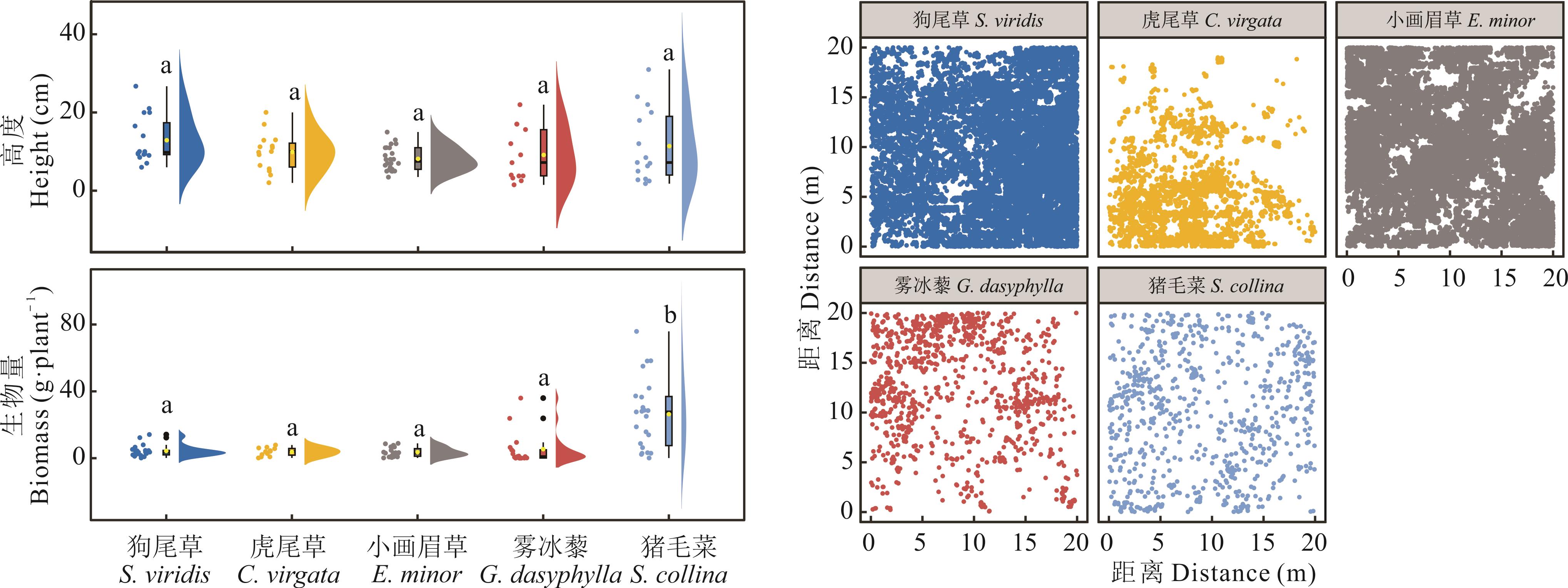
Fig.1 Height, biomass, and point diagram of individual distribution for different populations
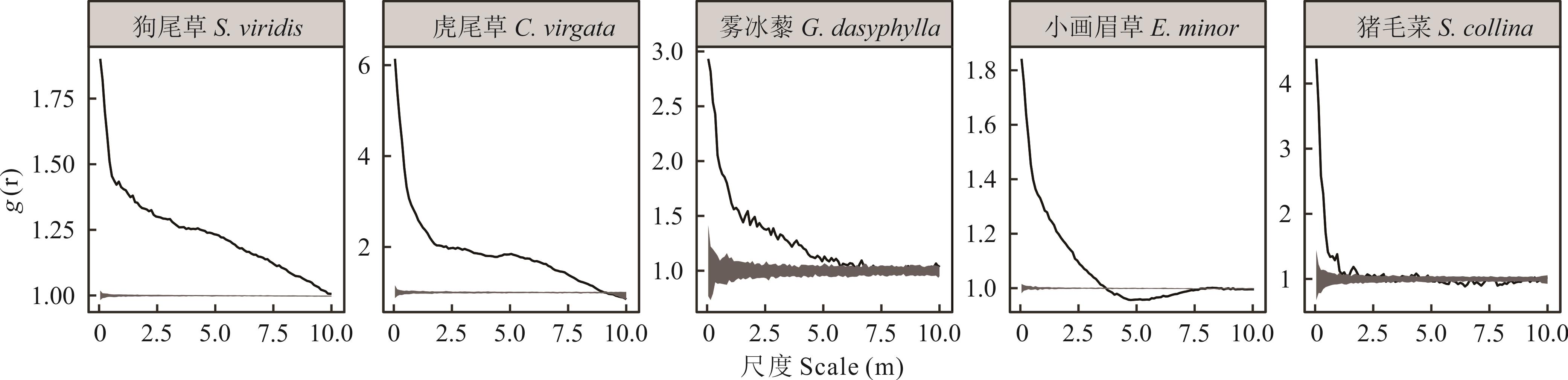
Fig.2 Point pattern analysis of species based on complete spatial randomness model

Fig.3 Point pattern analysis of species based on Poisson cluster process
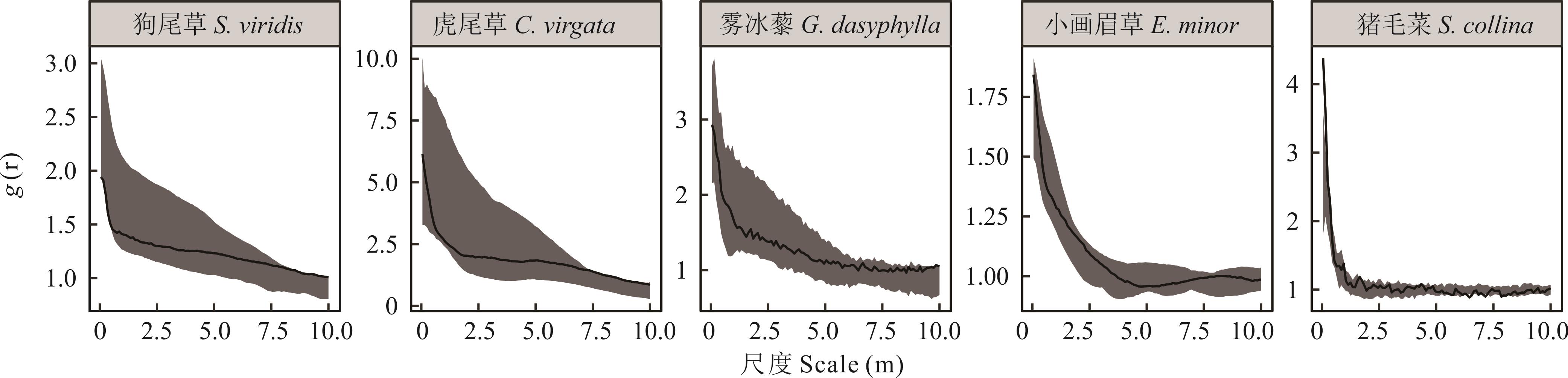
Fig.4 Point pattern analysis of species based on nested double-cluster process
| 1 | Wang X T, Chai J, Jiang C, et al. Population spatial pattern of Stipa grandis and its response to long-term overgrazing. Biodiversity Science, 2020, 28(2): 128-134. |
| 王鑫厅, 柴静, 姜超, 等. 典型草原大针茅种群空间格局及对长期过度放牧的响应. 生物多样性, 2020, 28(2): 128-134. | |
| 2 | Ma F, Wang S Z, Feng J C, et al. The study of the effect of tree death on spatial pattern and habitat associations in dominant populations of Dongling Mountains in Beijing. Acta Ecologica Sinica, 2018, 38(21): 7669-7678. |
| 马芳, 王顺忠, 冯金朝, 等. 北京东灵山优势种群树木死亡对空间格局与生境的影响. 生态学报, 2018, 38(21): 7669-7678. | |
| 3 | Wen Z F, Wei S G, Li L, et al. Spatial distribution patterns of forest community species at different latitudes in the subtropics. Acta Ecologica Sinica, 2022, 42(22): 9153-9164. |
| 温智峰, 魏识广, 李林, 等. 亚热带不同纬度森林群落物种空间分布格局. 生态学报, 2022, 42(22): 9153-9164. | |
| 4 | Fu Y, Huang K X, Cai J F, et al. Responses in spatial pattern of four dominant species to different water level environments in a freshwater marsh in the Sanjiang Plain. Biodiversity Science, 2022, 30(3): 4-14. |
| 付裕, 黄康祥, 蔡锦枫, 等. 三江平原沼泽湿地4种优势植物空间格局对不同水位环境的响应. 生物多样性, 2022, 30(3): 4-14. | |
| 5 | Bell G. The distribution of abundance in neutral communities. The American Naturalist, 2000, 155(5): 606-617. |
| 6 | Lv T. Analysis on species coexistence and diversity maintenance of three forest communities at Mt. Huangshan. Nanjing: Nanjing Forestry University, 2023. |
| 吕婷. 黄山三种森林群落的物种共存与多样性维持机制. 南京: 南京林业大学, 2023. | |
| 7 | Mei J L, Zhuang F H, Ma J M, et al. Spatial point pattern analysis of Alchornea trewioides population clonal growth in the karst area of Guilin. Acta Ecologica Sinica, 2017, 37(9): 3164-3171. |
| 梅军林, 庄枫红, 马姜明, 等. 桂林喀斯特地区克隆生长红背山麻杆种群的点格局分析. 生态学报, 2017, 37(9): 3164-3171. | |
| 8 | Liu M X. Spatial distribution and spatial association of Potentilla fruticosa populations on different slope aspects in subalpine meadow. Chinese Journal of Applied Ecology, 2017, 28(6): 1817-1823. |
| 刘旻霞. 亚高寒草甸不同坡向金露梅种群的空间分布格局及空间关联. 应用生态学报, 2017, 28(6): 1817-1823. | |
| 9 | Shen G C. The effects of habitat heterogeneity and dispersal limitation subtropical and tropical forests on species diversity. Hangzhou: Zhejiang University, 2011. |
| 沈国春. 生境异质性和扩散限制对亚热带和热带森林物种多样性维持的作用. 杭州: 浙江大学, 2011. | |
| 10 | Wu C P, Yuan W G, Sheng W X, et al. Spatial distribution patterns and associations of tree species in typical natural secondary forest communities in Zhejiang Province. Acta Ecologica Sinica, 2018, 38(2): 537-549. |
| 吴初平, 袁位高, 盛卫星, 等. 浙江省典型天然次生林主要树种空间分布格局及其关联性. 生态学报, 2018, 38(2): 537-549. | |
| 11 | Condit R, Ashton P S, Baker P, et al. Spatial patterns in the distribution of tropical tree species. Science, 2000, 288(5470): 1414-1418. |
| 12 | Connell J H. On the role of natural enemies in preventing competitive exclusion in some marine animals and in rain forest trees // Den Boer P J, Gradwell G R. Dynamics of populations. Wageningen, the Netherlands: Centre for Agricultural Publishing and Documentation, 1971: 298-312. |
| 13 | Janzen D H. Herbivores and the number of tree species in tropical forests. The American Naturalist, 1970, 104(940): 501-528. |
| 14 | Zhang L. Spatial pattern and resource allocation of three shrubs in response to grazing disturbance in western Ordos. Hohhot: Inner Mongolia Agricultural University, 2022. |
| 张磊. 西鄂尔多斯三种灌木空间格局及资源分配对放牧干扰的响应. 呼和浩特: 内蒙古农业大学, 2022. | |
| 15 | Wang X T, Zhang W H, Jiang C, et al. Point pattern analysis under conditions of replicated sampling. Chinese Journal of Plant Ecology, 2017, 41(5): 577-584. |
| 王鑫厅, 张维华, 姜超, 等. 重复取样条件下的点格局分析. 植物生态学报, 2017, 41(5): 577-584. | |
| 16 | Wang X T, Wang D J, Li H B, et al. Cumulative effects of K-function in the research of point patterns. Chinese Journal of Applied Ecology, 2022, 33(5): 1275-1282. |
| 王鑫厅, 王殿杰, 李海兵, 等. 点格局研究过程中K-函数的累积效应. 应用生态学报, 2022, 33(5): 1275-1282. | |
| 17 | Li Y F, Chen L, Li X B, et al. Point pattern analysis of an Artemisia scoparia seedling population under different soil conditions in a desert steppe. Acta Ecologica Sinica, 2019, 39(17): 6273-6281. |
| 李月飞, 陈林, 李学斌, 等. 荒漠草原不同土壤条件下猪毛蒿幼苗种群的点格局分析. 生态学报, 2019, 39(17): 6273-6281. | |
| 18 | Wang X T, Hou Y L, Liang C Z, et al. Point pattern analysis based on different null models for detecting spatial patterns. Biodiversity Science, 2012, 20(2): 151-158. |
| 王鑫厅, 侯亚丽, 梁存柱, 等. 基于不同零模型的点格局分析. 生物多样性, 2012, 20(2): 151-158. | |
| 19 | Verdu M, Garcia-Fayos P. Nucleation processes in a Mediterranean bird-dispersed plant. Functional Ecology, 1996(10): 275-280. |
| 20 | Li X R, Xiao H L, Liu L C, et al. Long-term effects of sand-binding vegetation on the restoration of biodiversity in Shapotou region of Tengger Desert, Northern China. Journal of Desert Research, 2005, 25(2): 173-181. |
| 李新荣, 肖洪浪, 刘立超, 等. 腾格里沙漠沙坡头地区固沙植被对生物多样性恢复的长期影响. 中国沙漠, 2005, 25(2): 173-181. | |
| 21 | Li X R, Zhao Y, Hui R, et al. Progress and trend of development of restoration ecology research in the arid regions of China. Progress in Geography, 2014, 33(11): 1435-1443. |
| 李新荣, 赵洋, 回嵘, 等. 中国干旱区恢复生态学研究进展及趋势评述. 地理科学进展, 2014, 33(11): 1435-1443. | |
| 22 | Li X R, Zhou H Y, Wang X P, et al. Ecological restoration and recovery in arid desert regions of China: A review for 60-year research progresses of Shapotou Desert Research and Experiment Station, Chinese Academy of Sciences. Journal of Desert Research, 2016, 36(2): 247-264. |
| 李新荣, 周海燕, 王新平, 等. 中国干旱沙区的生态重建与恢复: 沙坡头站60年重要研究进展综述. 中国沙漠, 2016, 36(2): 247-264. | |
| 23 | Ripley B D. Modelling spatial patterns. Journal of the Royal Statistical Society, 1977, 39(2): 172-212. |
| 24 | Wiegand T, Gunatilleke S, Gunatilleke N, et al. Analyzing the spatial structure of a Sri Lankan tree species with multiple scales of clustering. Ecology, 2007, 88(12): 3088-3102. |
| 25 | Wang X T, Wang W, Liang C Z, et al. Cleistogenes squarrosa population at different restorative succession stages in Inner Mongolia of China: A point pattern analysis. Chinese Journal of Applied Ecology, 2013, 24(7): 1793-1800. |
| 王鑫厅, 王炜, 梁存柱, 等. 不同恢复演替阶段糙隐子草种群的点格局分析. 应用生态学报, 2013, 24(7): 1793-1800. | |
| 26 | Wang X, Song K C, Xu D M, et al. Effects of artificial Caragana intermedia on seeds germination and seedlings growth of under-crown Agropyron mongolicum in desert steppe. Acta Agrestia Sinica, 2021, 29(11): 2470-2476. |
| 王星, 宋珂辰, 许冬梅, 等. 荒漠草原人工柠条对冠下蒙古冰草种子萌发和幼苗生长的影响. 草地学报, 2021, 29(11): 2470-2476. | |
| 27 | Li X H, Li X L, Jiang D M, et al. Germination strategy and ecological adaptability of Eragrostis pilosa. Chinese Journal of Applied Ecology, 2006, 17(4): 4607-4610. |
| 李雪华, 李晓兰, 蒋德明, 等. 画眉草种子萌发对策及生态适应性. 应用生态学报, 2006, 17(4): 4607-4610. | |
| 28 | Long L Q, Li X R. Effects of soil microbiotic crusts on seedling survival and seedling growth of two annual plants. Journal of Desert Research, 2003, 23(6): 53-57. |
| 龙利群, 李新荣. 土壤微生物结皮对两种一年生植物幼苗存活和生长的影响. 中国沙漠, 2003, 23(6): 53-57. | |
| 29 | Pan Y X, Wang X P. Spatial variation of soil moisture in revegetated desert area. Journal of Desert Research, 2007, 27(2): 250-256. |
| 潘颜霞, 王新平. 荒漠人工植被区浅层土壤水分空间变化特征分析. 中国沙漠, 2007, 27(2): 250-256. | |
| 30 | Xu A Y, Xu D M, Liu J L, et al. Point pattern analysis of dominant populations based on null models in desert steppe in Ningxia. Acta Ecologica Sinica, 2020, 40(12): 4180-4187. |
| 许爱云, 许冬梅, 刘金龙, 等. 基于零模型的宁夏荒漠草原优势种群点格局分析. 生态学报, 2020, 40(12): 4180-4187. | |
| 31 | Xu A Y, Xu D M, Cao B, et al. Spatial distribution patterns and interspecific relationships of Agropyron mongolicum populations in different desert steppe communities in Ningxia. Acta Prataculturae Sinica, 2020, 29(3): 171-178. |
| 许爱云, 许冬梅, 曹兵, 等. 宁夏荒漠草原不同群落蒙古冰草种群空间格局及种间关联性. 草业学报, 2020, 29(3): 171-178. | |
| 32 | Wang G H, Guo W T, Gou Q Q. Effects of sodium salt stress on seed germination of typical annuals in a desert-oasis ecotone of Hexi Corridor, China. Chinese Journal of Applied Ecology, 2020, 31(6): 1941-1947. |
| 王国华, 郭文婷, 缑倩倩. 钠盐胁迫对河西走廊荒漠绿洲过渡带典型一年生草本植物种子萌发的影响. 应用生态学报, 2020, 31(6): 1941-1947. | |
| 33 | Chen S C, Poschlod P, Antoelli A, et al. Trade-off between seed dispersal in space and time. Ecology Letters, 2020, 23(11): 1635-1642. |
| 34 | Lu R, Zheng J Y, Liu Y, et al. Nurse effects of patch-canopy microhabitats promote herbs community establishment in sandy land. Ecological Engineering, 2018, 118(8): 126-133. |
| 35 | Filazzola A, Lortie C J. A systematic review and conceptual framework for the mechanistic pathways of nurse plants. Global Ecology and Biogeography, 2014, 23(12): 1335-1345. |
| 36 | Hastwell G T, Facelli J M. Differing effects of shade-induced facilitation on growth and survival during the establishment of a chenopod shrub. Journal of Ecology, 2003, 91(6): 941-950. |
| 37 | Song N P, Wang X, Chen L, et al. Co-existence mechanisms of plant species within “soil islands” habitat of desert steppe. Biodiversity Science, 2018, 26(7): 667-677. |
| 宋乃平, 王兴, 陈林, 等. 荒漠草原“土岛”生境群落物种共存机制. 生物多样性, 2018, 26(7): 667-677. | |
| 38 | He F L, Zhao H R, Wang Z W, et al. Effect of biological soil crusts on seed settlement of Reaumuria soongorica and its mechanism in arid desert area. Acta Ecologica Sinica, 2023, 43(1): 304-312. |
| 何芳兰, 赵赫然, 王忠文, 等. 干旱沙区生物土壤结皮对红砂种子定居的影响及作用机制. 生态学报, 2023, 43(1): 304-312. | |
| 39 | Chen M C, Zhang J G, Feng L, et al. The composition and vertical distribution characteristics of soil seed banks in soil coverage with biocrusts in the Shapotou Region. Acta Ecologica Sinica, 2017, 37(22): 7614-7623. |
| 陈孟晨, 张景光, 冯丽, 等. 沙坡头地区生物结皮覆盖区土壤种子库组成及垂直分布特征. 生态学报, 2017, 37(22): 7614-7623. |
| [1] | Ying LEI, Jie LUO, Xu-man GUO, Er-ting BI, Jin-chun LIU. Microhabitat plant diversity and biomass differences in abandoned karst farmland and their driving factors [J]. Acta Prataculturae Sinica, 2024, 33(2): 28-38. |
| [2] | XU Ai-yun, XU Dong-mei, CAO Bing, LIU Jin-long, YU-Shuang, GUO Yan-ju, MA Xiao-jing. Spatial distribution patterns and interspecific relationships of Agropyron mongolicum populations in different desert steppe communities in Ningxia [J]. Acta Prataculturae Sinica, 2020, 29(3): 171-178. |
| [3] | SUN Hai-rong, CHE Zhao-bi, CHEN Yi-shi, LU Wei-hua, WANG Shu-lin, LI Na-na, XIN Huai-lu. Ecological adaptability of biological traits and population distribution patterns for the ephemeral plant Leontice incerta in desert habitats [J]. Acta Prataculturae Sinica, 2019, 28(7): 198-207. |
| [4] | LU Wei-hua, ZHU Jin-zhong, WANG Dong-jiang, JIN Gui-li, YU Bo. Point pattern analysis of Seriphidium transiliense populations under two degradation gradients in the Northern Tianshan Mountains [J]. Acta Prataculturae Sinica, 2009, 18(5): 142-149. |
| Viewed | ||||||
|
Full text |
|
|||||
|
Abstract |
|
|||||