

ISSN 1004-5759 CN 62-1105/S
草业学报 ›› 2022, Vol. 31 ›› Issue (3): 1-15.DOI: 10.11686/cyxb2020573
• 研究论文 •
沈洁1( ), 丁蕾1, 辛晓平1(), 张翔1,2, 徐大伟1, 侯路路1, 闫瑞瑞1
收稿日期:2020-12-23
修回日期:2021-03-01
出版日期:2022-03-20
发布日期:2022-01-15
通讯作者:
辛晓平
作者简介:Corresponding author. E-mail: xinxiaoping@caas.cn基金资助:
Jie SHEN1(), Lei DING1, Xiao-ping XIN1(), Xiang ZHANG1,2, Da-wei XU1, Lu-lu HOU1, Rui-rui YAN1
Received:2020-12-23
Revised:2021-03-01
Online:2022-03-20
Published:2022-01-15
Contact:
Xiao-ping XIN
摘要:
放牧活动不但影响草原生态过程,而且改变草原群落空间格局。为进行草地冠层连续变化的尺度对放牧强度响应的研究,基于无人机机载激光雷达和多光谱遥感获取亚米级的草原冠层数据,利用小波分析方法研究了不同放牧强度下草原冠层空间格局及其尺度特征,探究草原冠层高度(CH)、植被覆盖度(FVC)、归一化植被指数(NDVI)等不同冠层参数空间尺度特征对放牧强度的响应。结果表明:CH、FVC、NDVI的小波方差随放牧强度增大呈下降趋势,草原冠层空间结构整体趋于均匀;小波方差和系数实部分析显示,CH,FVC和NDVI的空间格局存在170~180 m、116~140 m等2个主特征尺度,不随放牧强度而变化,较为稳定;中度、重度放牧使植物群落在空间中产生了许多小斑块,植被盖度的空间格局在小尺度上的变化较大。
沈洁, 丁蕾, 辛晓平, 张翔, 徐大伟, 侯路路, 闫瑞瑞. 基于无人机激光雷达与多光谱数据的不同放牧强度下草原冠层尺度特征研究[J]. 草业学报, 2022, 31(3): 1-15.
Jie SHEN, Lei DING, Xiao-ping XIN, Xiang ZHANG, Da-wei XU, Lu-lu HOU, Rui-rui YAN. Canopy scale characteristics of grassland under different grazing intensities based on UAV lidar and multispectral data[J]. Acta Prataculturae Sinica, 2022, 31(3): 1-15.

图1 试验区位置与概况
Fig.1 Location and overview of the experimental area

图2 研究小区剖面取样示例与对照组剖面数据
Fig.2 Research plot section sampling example and control profile data example
植被参数 Vegetation parameter | 数据产品 Data product | 分辨率 Resolution (m) | 获取时间Time (年-月-日 Year-month-day) |
|---|---|---|---|
| CH | HS-600无人机激光扫描系统CH产品 CH products of HS-600 UAV laser scanning system | 0.2 | 2018-09-11 |
| FVC | HS-600无人机激光扫描系统FVC产品 Fractional vegetation cover products of HS-600 UAV laser scanning system | 0.2 | 2018-09-11 |
| NDVI | 搭载MicaSense Red Edge-MX传感器Sense Fly无人机多光谱影像 Multispectral image of Sense Fly UAV with MicaSense Red Edge-MX sensor | 0.1 | 2018-09-11 |
表1 研究数据来源
Table 1 Research data sources
植被参数 Vegetation parameter | 数据产品 Data product | 分辨率 Resolution (m) | 获取时间Time (年-月-日 Year-month-day) |
|---|---|---|---|
| CH | HS-600无人机激光扫描系统CH产品 CH products of HS-600 UAV laser scanning system | 0.2 | 2018-09-11 |
| FVC | HS-600无人机激光扫描系统FVC产品 Fractional vegetation cover products of HS-600 UAV laser scanning system | 0.2 | 2018-09-11 |
| NDVI | 搭载MicaSense Red Edge-MX传感器Sense Fly无人机多光谱影像 Multispectral image of Sense Fly UAV with MicaSense Red Edge-MX sensor | 0.1 | 2018-09-11 |
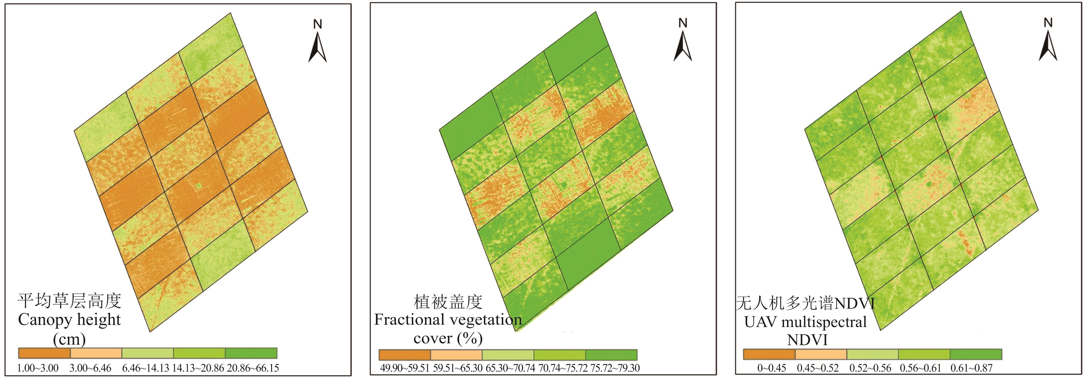
图3 无人机激光雷达估算
Fig.3 UAV lidar estimates
植被参数 Vegetation parameter | 项目 Item | 放牧强度 Grazing intensity | |||
|---|---|---|---|---|---|
| GI0 | GI1 | GI3 | GI5 | ||
| CH (cm) | 均值Mean | 10.6136 | 6.6287 | 4.4974 | 2.4724 |
| 标准差Standard deviation | 4.9968 | 3.5149 | 2.5772 | 1.0140 | |
| FVC (%) | 均值Mean | 78.6755 | 76.2432 | 72.1455 | 61.7160 |
| 标准差Standard deviation | 0.8188 | 3.6008 | 4.7962 | 5.7201 | |
| NDVI | 均值Mean | 0.5731 | 0.5617 | 0.5699 | 0.5184 |
| 标准差Standard deviation | 0.5040 | 0.3990 | 0.3700 | 0.4460 | |
表2 CH、FVC、NDVI在不同放牧强度下的均值与标准差
Table 2 Mean and standard deviation of CH, FVC and NDVI under different grazing intensities
植被参数 Vegetation parameter | 项目 Item | 放牧强度 Grazing intensity | |||
|---|---|---|---|---|---|
| GI0 | GI1 | GI3 | GI5 | ||
| CH (cm) | 均值Mean | 10.6136 | 6.6287 | 4.4974 | 2.4724 |
| 标准差Standard deviation | 4.9968 | 3.5149 | 2.5772 | 1.0140 | |
| FVC (%) | 均值Mean | 78.6755 | 76.2432 | 72.1455 | 61.7160 |
| 标准差Standard deviation | 0.8188 | 3.6008 | 4.7962 | 5.7201 | |
| NDVI | 均值Mean | 0.5731 | 0.5617 | 0.5699 | 0.5184 |
| 标准差Standard deviation | 0.5040 | 0.3990 | 0.3700 | 0.4460 | |
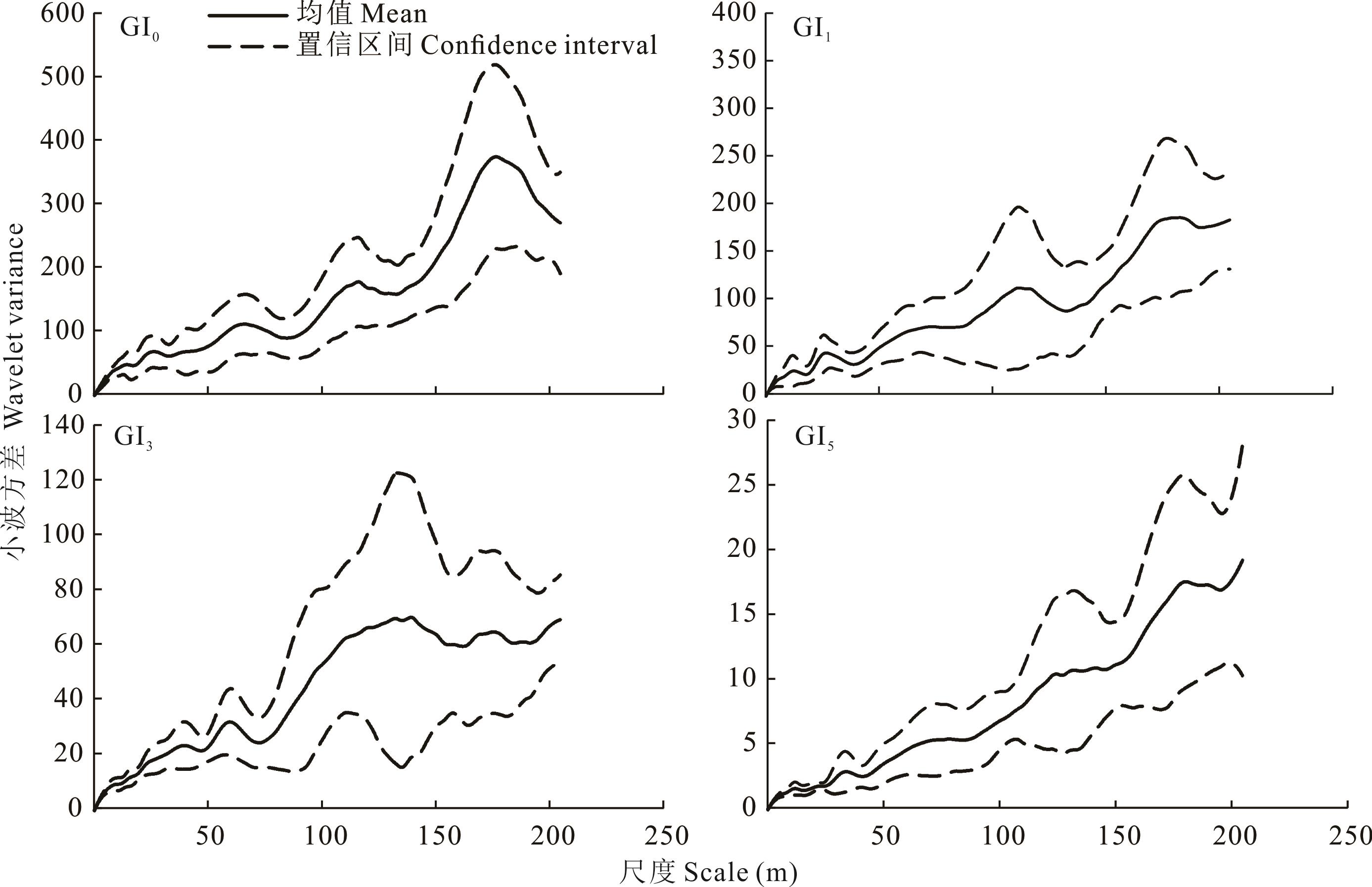
图4 不同放牧梯度下CH小波方差均值与置信区间
Fig.4 Mean variance and confidence interval of CH wavelet under different grazing intensities
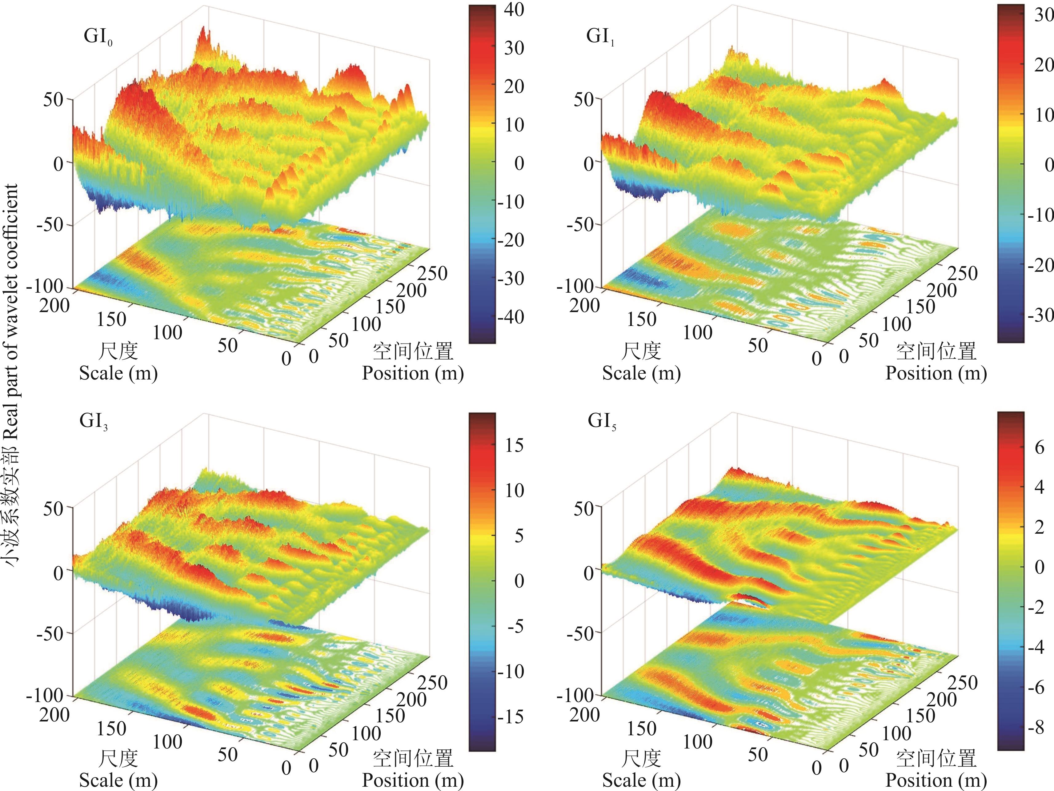
图5 不同放牧强度下CH小波系数实部
Fig.5 Real part of wavelet coefficients of CH under different grazing intensities

图6 不同放牧强度下FVC的小波方差均值与置信区间
Fig.6 Mean variance and confidence interval of FVC wavelet under different grazing intensities
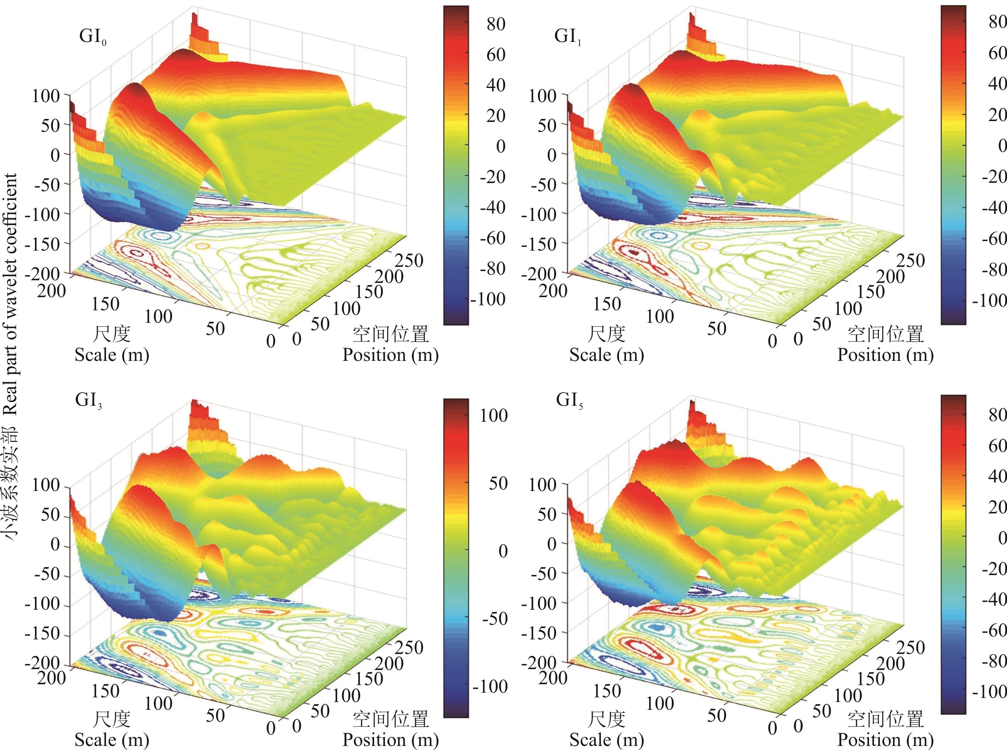
图7 不同放牧强度下FVC小波系数实部
Fig.7 Real part of FVC wavelet coefficients under different grazing intensities
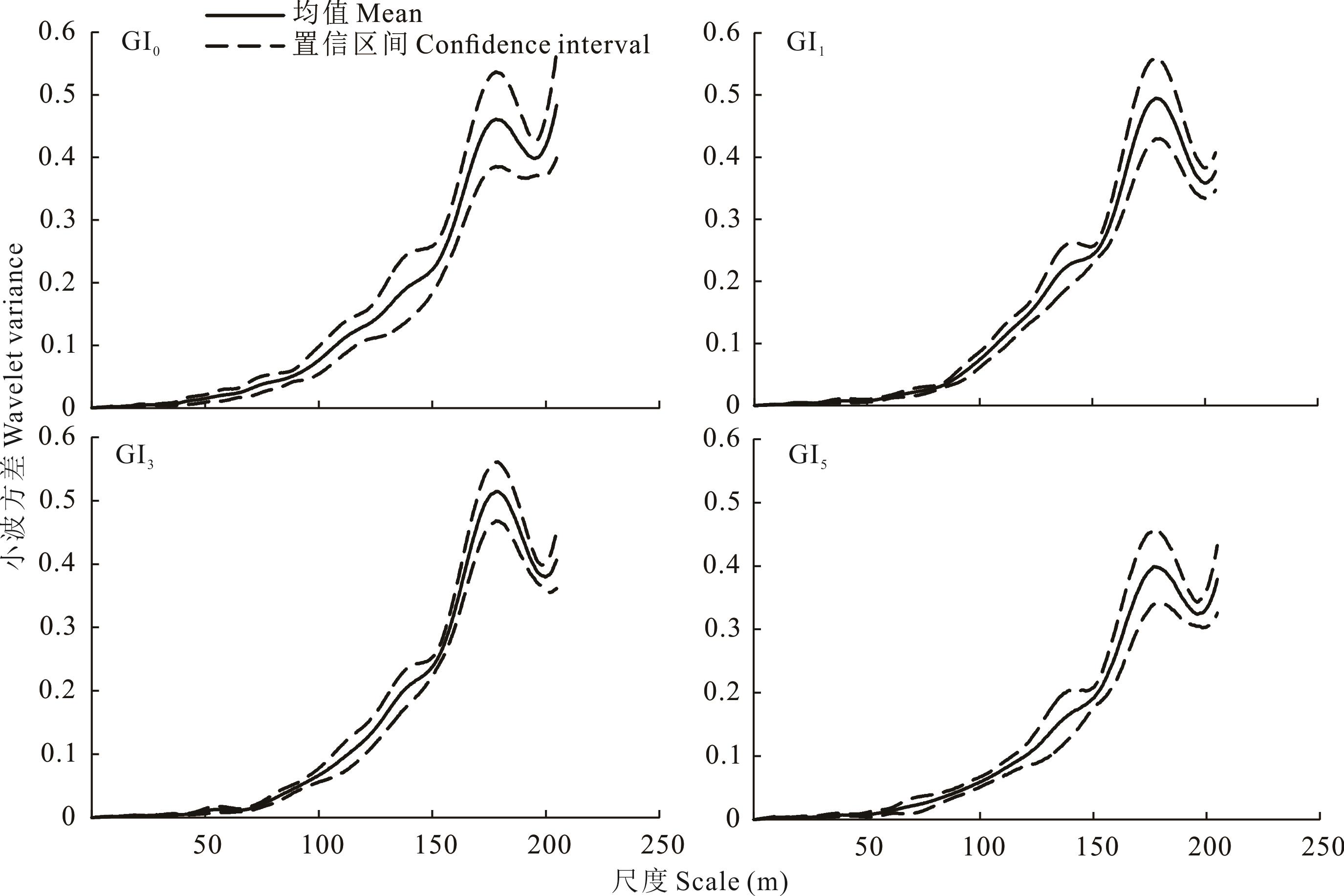
图8 不同放牧强度下NDVI的小波方差均值与置信区间
Fig.8 Mean variance and confidence interval of NDVI wavelet under different grazing intensities

图9 不同放牧强度下NDVI小波系数实部
Fig.9 Real part of NDVI wavelet coefficients under different grazing intensities
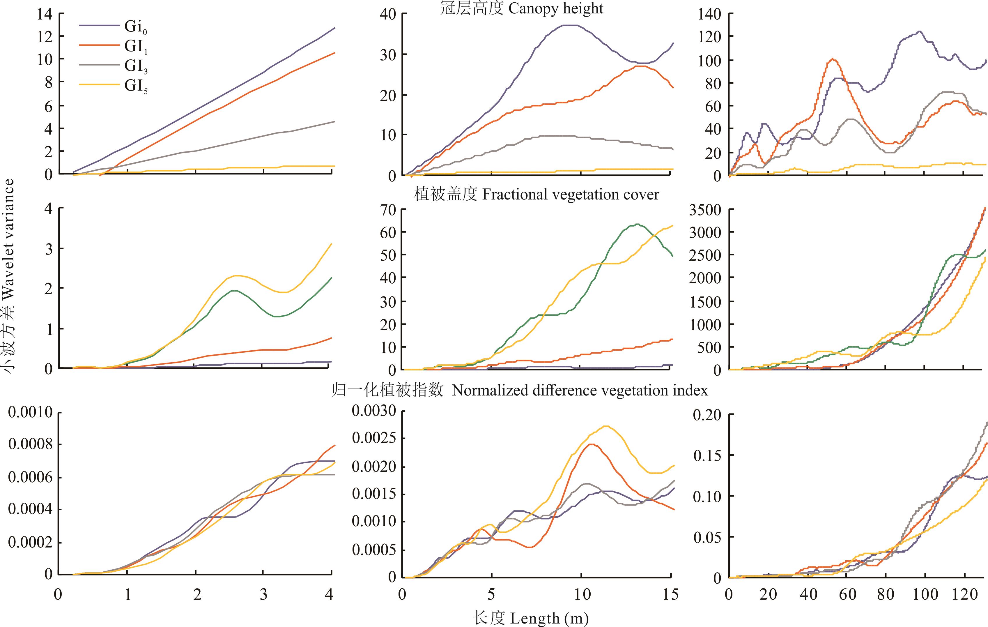
图10 3个尺度范围下不同放牧梯度的草地冠层高度、植被覆盖度和归一化植被指数的小波方差
Fig.10 Wavelet variance of grassland canopy height (CH), fractional vegetation coverage (FVC) and normalized difference vegetation index (NDVI) under different grazing intensities in the three scales
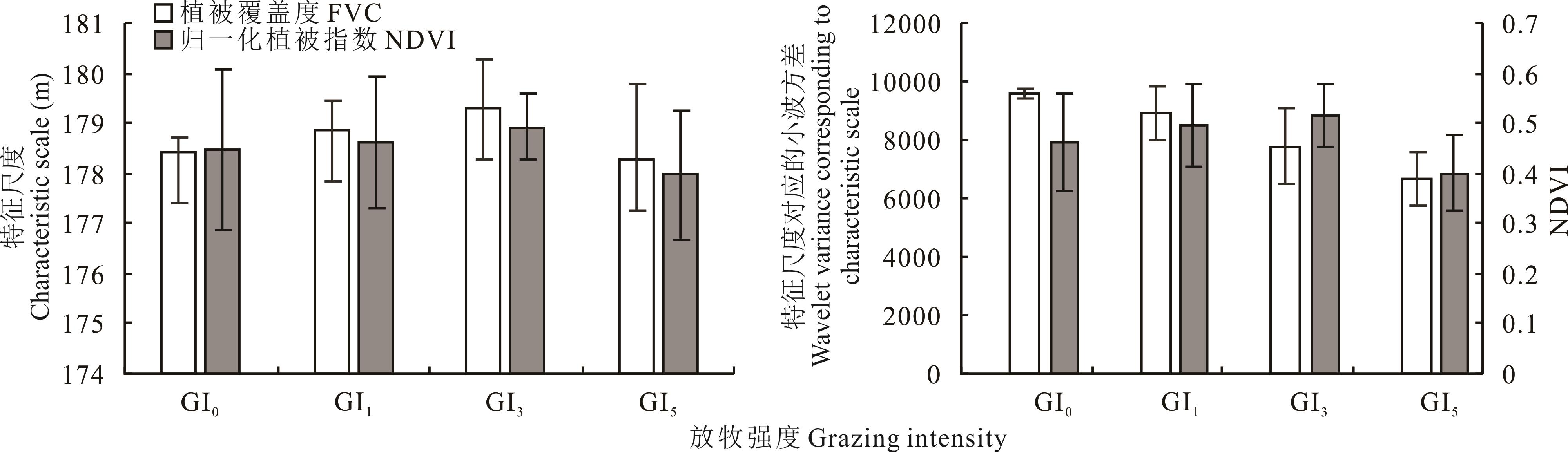
图11 FVC和NDVI在不同放牧强度下第一主特征尺度均值与其对应的小波方差均值
Fig.11 Mean values of the the first principal characteristic scale and the wavelet variance corresponding to the first principal characteristic scale under different grazing intensities of FVC and NDVI
| 1 | Fang J Y, Piao S L, Tang Z Y, et al. Interannual variability in net primary production and precipitation. Science, 2001, 293: 1723. |
| 2 | Bai Y, Han X, Wu J, et al. Ecosystem stability and compensatory effects in the Inner Mongolia grassland. Nature, 2004, 431: 181-184. |
| 3 | Zhang F, Chen D L, Zhao M L, et al. Effects of grazing intensity on spatial heterogeneity of the constructive species Stipa breviflora in desert steppe. Chinese Journal of Applied Ecology, 2019, 30(9): 3046-3056. |
| 张峰, 陈大岭, 赵萌莉, 等. 放牧强度对荒漠草原建群种短花针茅空间异质性的影响. 应用生态学报, 2019, 30(9): 3046-3056 . | |
| 4 | Tan H Y, Yan R R, Yan Y C, et al. Phospholipid fatty acid analysis of soil microbial communities under different grazing intensities in meadow steppe. Acta Prataculturae Sinica, 2015, 24(3):115-121. |
| 谭红妍, 闫瑞瑞, 闫玉春, 等.不同放牧强度下温性草甸草原土壤微生物群落结构PLFAS分析. 草业学报, 2015, 24(3): 115-121. | |
| 5 | Ren J Z. The scientific research method of grass industry. Beijing: China Agriculture Press, 1998. |
| 任继周. 草业科学研究方法. 北京: 中国农业出版社, 1998. | |
| 6 | Li J H, Li Z Q, Ren J Z. The effect of grazing on grassland plants. Acta Prataculturae Sinica, 2002(1): 4-11. |
| 李金花, 李镇清, 任继周. 放牧对草原植物的影响. 草业学报, 2002(1): 4-11. | |
| 7 | Wu J G. The key research topics in landscape ecology. Acta Ecologica Sinica, 2004, 24(9): 2074-2076. |
| 邬建国. 景观生态学中的十大研究论题. 生态学报, 2004(9): 2074-2076. | |
| 8 | Wu J G. Landscape ecology-concepts and theories. Chinese Journal of Ecology, 2000, 19(1): 42-52. |
| 邬建国. 景观生态学——概念与理论. 生态学杂志, 2000, 19(1): 42-52. | |
| 9 | Legendre P, Fortin M J. Spatial pattern and ecological analysis. Plant Ecology, 1989, 80(2):107-138. |
| 10 | Wang Z Q, Wang Q C, Li H B. Characteristics and comparison of spatial heterogeneity of the main species of Korean pine in old growth forests. Chinese Journal of Plant Ecology, 2000(6): 718-723. |
| 王政权, 王庆成, 李哈滨. 红松老龄林主要树种的空间异质性特征与比较的定量研究. 植物生态学报, 2000(6): 718-723. | |
| 11 | Li X M. Research on the spatial scale of eco-environment based on wavelet transform. Fuzhou: Fujian Normal University, 2008. |
| 李小梅. 基于小波变换的生态环境空间尺度研究. 福州: 福建师范大学, 2008. | |
| 12 | Simon H A. The organization of complex systems//In: Pattee H H, ed. Hierarchy theory: The challenge of complex systems. New York: George Braziller, 1973: 1-27. |
| 13 | Wu J. Hierarchy and scaling: Extrapolating information along a scaling ladder. Canadian Journal of Remote Sensing, 1999, 25: 367-380. |
| 14 | O’Neill R V. Recent developments in ecological theory: Hierarchy and scale//Scott J M, Tear T H, Davis F W, ed. GAP analysis: A landscape approach to biodiversity planning. Bethseda: American society explicit hierarchical approach to modeling complex ecological systems: Theory and applications. Ecological Modeling, 2002, 153: 7-26. |
| 15 | Robinson W S. Ecological correlations and the behavior of individuals. International Journal of Epidemiology, 1950, 15(3):351-357. |
| 16 | McCarthy H H, Hook J C, Knos D S. The measurement of association in industrial geography. Iowa: State University of Iowa, 1956. |
| 17 | Alker H R. A typology of ecological fallacies//Dogan M, Rokkan S. Quantitative ecological analysis. Cambridge: Massachusetts Institute of Technology, 1969: 69-86. |
| 18 | National Research Council. Rediscovering geography: New relevance for science and society. Washington, DC: National Academies Press, 1997. |
| 19 | Cai Y L, Lu D D, Zhou Y X, et al. Progress and international trend of geographical sciences in China. Acta Geographica Sinica, 2004(6): 803-810. |
| 蔡运龙, 陆大道, 周一星, 等. 地理科学的中国进展与国际趋势. 地理学报, 2004(6): 803-810. | |
| 20 | Li X W. Retrospect, prospect and innovation in quantitative remote sensing. Journal of Henan University (Natural Science Edition), 2005(4): 49-56. |
| 李小文. 定量遥感的发展与创新. 河南大学学报(自然科学版), 2005(4): 49-56. | |
| 21 | Qiu Y, Fu B J . Spatial variation and scale variation in soil and water loss in heterogeneous landscape: A review. Acta Ecologica Sinica, 2004, 24(2): 330-337. |
| 邱扬, 傅伯杰. 异质景观中水土流失的空间变异与尺度变异. 生态学报, 2004, 24(2): 330-337. | |
| 22 | Lv Y H, Fu B J . Ecological scale and scaling. Acta Ecologica Sinica, 2001, 21(12): 2096-2105. |
| 吕一河, 傅伯杰. 生态学中的尺度及尺度转换方法. 生态学报, 2001, 21(12): 2096-2105. | |
| 23 | Xie J B, Liu T, Wei P, et al. Ecological application of wavelet analysis in the scaling of spatial distribution patterns of Ceratoides ewersmanniana. Acta Ecologica Sinica, 2007, 27(7): 2704-2714. |
| 谢江波, 刘彤, 魏鹏, 等.小波分析方法在心叶驼绒藜(Ceratoides ewersmanniana)空间格局尺度推绎研究中的应用. 生态学报, 2007, 27(7):2704-2714. | |
| 24 | Lian J L. Applications of wavelet multi-resolution analysis. Fuzhou: Fujian Normal University, 2008. |
| 连江龙. 小波多尺度分析的应用研究. 福州: 福建师范大学, 2008. | |
| 25 | Gulinck H, Dufourmont H, Coppin P. Landscape research, landscape policy and earth observation. International Journal of Remote Sensing, 2000, 21(13): 2541-2554. |
| 26 | Sun D F. Identifying multi-scale spatial patterns of landscape from wavelet and semivariogram analysis of IKONOS PAN remote sensing data. Acta Ecologica Sinica, 2003(3): 405-413. |
| 孙丹峰. IKONOS影像景观格局特征尺度的小波与半方差分析. 生态学报, 2003(3): 405-413. | |
| 27 | Zhang P L. Effect of grazing intensity on characteristics of vegetation communities in the alpine meadow steppe. Xianyang: Northwest Agriculture & Forestry University, 2013. |
| 张鹏莉. 放牧对青藏高原草地植被群落结构特征的影响. 咸阳: 西北农林科技大学, 2013. | |
| 28 | Li L F, Shao Q M. Processing of the laser radar point cloud data based on the Terrasolid software. Urban Geotechnical Investigation & Surveying, 2013(5): 67-70. |
| 李莲芳, 邵秋铭. 基于Terrasolid软件的激光雷达点云数据处理. 城市勘测, 2013(5): 67-70. | |
| 29 | Jia K, Yao Y J, Wei X Q, et al. A review on fractional vegetation cover estimation using remote sensing. Advances in Earth Science, 2013, 28(7): 774-782. |
| 贾坤, 姚云军, 魏香琴, 等. 植被覆盖度遥感估算研究进展. 地球科学进展, 2013, 28(7): 774-782. | |
| 30 | Cao B X, Huang J F. Research on comparison and application of LIDAR point cloud data processing software. Mine Surveying, 2019, 47(1): 109-112. |
| 曹炳霞, 黄剑飞. 激光雷达点云数据处理软件对比及其应用研究. 矿山测量, 2019, 47(1): 109-112. | |
| 31 | Shi J Q, Shi Z L. Study on the application of TerraScan to filtering LiDAR data cloud. Journal of Huaihai Institute of Technology (Natural Science Edition), 2011(3): 51-54. |
| 史建青, 史照良. TerraScan在LiDAR点云滤波中的应用研究. 淮海工学院学报(自然科学版), 2011(3): 51-54. | |
| 32 | Wang D L, Xin X P, Shao Q Q, et al. Modeling aboveground biomass in Hulunber grassland ecosystem by using unmanned aerial vehicle discrete lidar.Sensors (Basel, Switzerland), 2017, 17(1): http://med.wanfangdata.com.cn/Paper/Detail/PeriodicalPaper_PM28106819. |
| 33 | Zhang X. Research on vegetation biomass inversion based on UAV LIDAR and multispectral data. Hohhot: Inner Mongolia Normal University, 2020. |
| 张翔. 基于无人机激光雷达和多光谱数据的植被生物量反演研究. 呼和浩特: 内蒙古师范大学, 2020. | |
| 34 | Luo G K. A study on Morlet wavelet transform theory and application with software implementation. Nanjing: Nanjing University of Aeronautics and Astronautics, 2007. |
| 罗光坤. Morlet小波变换理论与应用研究及软件实现. 南京: 南京航空航天大学, 2007. | |
| 35 | Hou L L, Yan R R, Zhang Y, et al. Effects of grazing intensity on functional traits of Leymus chinensis in meadow steppe. Chinese Journal of Agricultural Sciences, 2020, 53(13): 2562-2572. |
| 侯路路, 闫瑞瑞, 张宇, 等. 放牧强度对草甸草原羊草功能性状的影响. 中国农业科学, 2020, 53(13): 2562-2572. | |
| 36 | Xin X P, Yang Z Y, Tian X Z, et al. Patch dynamics of alkaline Leymus chinensis grassland under grazed and ungrazed conditions. Acta Phytoecologica Sinica, 2000(6): 656-661. |
| 辛晓平, 杨正宇, 田新智, 等. 放牧和围封条件下羊草碱化草地中斑块分布格局研究. 植物生态学报, 2000(6): 656-661. | |
| 37 | Zhang C X, Nan Z B. Research progress on effects of grazing on physical and chemical characteristics of grassland soil. Acta Prataculturae Sinica, 2010, 19(4): 204-211. |
| 张成霞, 南志标. 放牧对草地土壤理化特性影响的研究进展. 草业学报, 2010, 19(4): 204-211. | |
| 38 | Liu J X, Gong Y B, Zuo Q, et al. A review of mountain grazing-paths and vegetation spatial heterogeneity. Acta Prataculturae Sinica, 2012, 21(1): 254-261. |
| 刘金鑫, 宫渊波, 左琴, 等. 山地牧道与植被空间异质性研究评述. 草业学报, 2012, 21(1): 254-261. | |
| 39 | Garcia F, Carrère P, Soussana J F, et al. Characterisation by fractal analysis of foraging paths of ewes grazing heterogeneous swards. Applied Animal Behaviour Science, 2005, 93(1/2):19-37. |
| 40 | Garcia F, Carrère P, Soussana J F, et al. The ability of sheep at different stocking rates to maintain the quality and quantity of their diet during the grazing season. Journal of Agricultural Science, 2003, 140(1): 113-124. |
| 41 | Morton J D, Baird D B. Spatial distribution of dung patches under sheep grazing. New Zealand Journal of Agricultural Research, 1990, 33(2): 285-294. |
| 42 | Yan R R, Xin X P, Zhang B H, et al. Influence of cattle grazing gradient on plant community characteristics in Hulunber meadow steppe. Chinese Journal of Grassland, 2010, 32(3): 62-67. |
| 闫瑞瑞, 辛晓平, 张保辉, 等. 肉牛放牧梯度对呼伦贝尔草甸草原植物群落特征的影响. 中国草地学报, 2010, 32(3): 62-67. |
| [1] | 刘佳丽, 范建容, 张茜彧, 杨超, 徐富宝, 张晓雪, 梁博. 高寒草地生长季/非生长季植被盖度遥感反演[J]. 草业学报, 2021, 30(9): 15-26. |
| [2] | 乔宇鑫, 钟华平, 朱华忠, 邵小明, 李愈哲. 中国北方温带草原区土壤容重分层数据重建与空间格局分析[J]. 草业学报, 2021, 30(1): 1-11. |
| [3] | 孙世贤, 丁勇, 李夏子, 吴新宏, 闫志坚, 尹强, 李金卓. 放牧强度季节调控对荒漠草原土壤风蚀的影响[J]. 草业学报, 2020, 29(7): 23-29. |
| [4] | 王梦佳, 孙睿, 刘喆, 辛晓平, 刘刚, 张蕾, 乔晨. 基于遥感数据的呼伦贝尔草原放牧强度研究[J]. 草业学报, 2017, 26(6): 28-36. |
| [5] | 陶冶, 刘耀斌, 吴甘霖, 张元明. 准噶尔荒漠区域尺度浅层土壤化学计量特征及其空间分布格[J]. 草业学报, 2016, 25(7): 13-23. |
| [6] | 乔宇鑫, 朱华忠, 钟华平, 伍兆文, 孟雷, 周李磊. 内蒙古草地地下生物量空间格局分析[J]. 草业学报, 2016, 25(6): 1-12. |
| [7] | 曹旭娟, 干珠扎布, 梁艳, 高清竹, 张勇, 李玉娥, 万运帆, 旦久罗布. 基于NDVI的藏北地区草地退化时空分布特征分析[J]. 草业学报, 2016, 25(3): 1-8. |
| [8] | 楚彬, 花立民, 周延山, 刘丽, 李帅. 祁连山东段不同放牧强度下高原鼢鼠栖息地选择分析[J]. 草业学报, 2016, 25(1): 179-186. |
| [9] | 周李磊, 朱华忠, 钟华平, 杨华, 索菲娅, 邵小明, 周星杰. 新疆伊犁地区草地土壤容重空间格局分析[J]. 草业学报, 2016, 25(1): 64-75. |
| [10] | 苗福泓, 薛冉, 郭正刚, 沈禹颖. 青藏高原东北边缘高寒草甸植物种群生态位特征对牦牛放牧的响应[J]. 草业学报, 2016, 25(1): 88-97. |
| [11] | 陈钊, 梁新平, 侯扶江, 田苗苗, 张红瑞, 余莹, 管永卓, 王成章, 严学兵. 不同放牧强度下垂穗披碱草遗传多样性分析[J]. 草业学报, 2015, 24(8): 159-165. |
| [12] | 周道玮, 钟荣珍, 孙海霞, 黄迎新, 房义. 草地划区轮牧饲养原则及设计[J]. 草业学报, 2015, 24(2): 176-184. |
| [13] | 柴华,方江平,温丁,李杰,何念鹏. 内蒙古灌丛化草地取样位置对评估土壤碳氮贮量的影响[J]. 草业学报, 2014, 23(6): 28-35. |
| [14] | 张婷,翁月,姚凤娇,史印涛,崔国文,胡国富. 放牧强度对草甸植物小叶章及土壤化学计量比的影响[J]. 草业学报, 2014, 23(2): 20-28. |
| [15] | 章超斌,李建龙,张颖,周伟,钱育蓉,杨峰. 基于RGB模式的一种草地盖度定量快速测定方法研究[J]. 草业学报, 2013, 22(4): 220-226. |
| 阅读次数 | ||||||
|
全文 |
|
|||||
|
摘要 |
|
|||||