

ISSN 1004-5759 CN 62-1105/S
草业学报 ›› 2025, Vol. 34 ›› Issue (4): 1-15.DOI: 10.11686/cyxb2024180
• 研究论文 •
许雪梅1( ), 姜佳昌2, 牛欣1,3, 周宏伟4, 韩天虎5, 曹晓明6, 梁春燕7, 李旭东1, 牛得草1()
收稿日期:2024-05-14
修回日期:2024-07-18
出版日期:2025-04-20
发布日期:2025-02-19
通讯作者:
牛得草
作者简介:Corresponding author. E-mail: xiaocao0373@163.com基金资助:
Xue-mei XU1(), Jia-chang JIANG2, Xin NIU1,3, Hong-wei ZHOU4, Tian-hu HAN5, Xiao-ming CAO6, Chun-yan LIANG7, Xu-dong LI1, De-cao NIU1()
Received:2024-05-14
Revised:2024-07-18
Online:2025-04-20
Published:2025-02-19
Contact:
De-cao NIU
摘要:
草畜平衡实施效果评估对于草地合理管理以及草地畜牧业可持续性发展至关重要。本研究利用遥感技术获取了植被特征数据,并根据专家意见制定了草地植被指标基准值,开展了草畜平衡实施效果评估,且利用传统方法探讨了该方法的可靠性。另外,本研究通过构建综合草畜平衡指数(CFBI)进行了村级尺度的草畜平衡实施效果综合评定。基于遥感反演的草畜平衡实施效果评估结果显示,2022年山丹县部分草地存在超载情况,超载和严重超载面积仅占总面积的1.09%,各行政村草地之间的综合草畜平衡指数存在明显差异(-10.91~-3.72)。基于遥感技术的草畜平衡实施效果评估方法可以为山丹县草地禁牧区与放牧区的动态调整提供科学依据。
许雪梅, 姜佳昌, 牛欣, 周宏伟, 韩天虎, 曹晓明, 梁春燕, 李旭东, 牛得草. 基于遥感反演的草畜平衡实施效果评估方法探讨——以山丹县为例[J]. 草业学报, 2025, 34(4): 1-15.
Xue-mei XU, Jia-chang JIANG, Xin NIU, Hong-wei ZHOU, Tian-hu HAN, Xiao-ming CAO, Chun-yan LIANG, Xu-dong LI, De-cao NIU. Evaluation of forage-livestock balance implementation via remote sensing inversion: A case study in Shandan County, Gansu Province[J]. Acta Prataculturae Sinica, 2025, 34(4): 1-15.

图1 研究区位置、草地类型分布以及采样点基于自然资源部标准地图服务网站甘S(2023)10号和甘S(2023)322号标准地图制作,底图边界无修改。Based on the standard map service website Gan S(2023) No.10 and Gan S(2023) No.322 of the Ministry of Natural Resources, the boundary of the base map is not modified.
Fig.1 Location of study area, distribution of grassland types, and sampling points
草地类型 Grassland type | 植被盖度 Fractional vegetation coverage (FVC, %) | 植被盖度相对百分数的减少率 Rate of decrease in FVC as a percentage (T1) | 剩余牧草现存量 Residual biomass (RB,kg·hm-2) | 剩余牧草现存量相对百分数的减少率 Rate of decrease in RB as a percentage (T2) | 抗干扰能力 Anti-interference ability (A) |
|---|---|---|---|---|---|
| 高寒草甸类Alpine meadow | 50 | - | 200 | - | 6 |
| 山地草甸类Mountain meadow | 50 | - | 270 | - | 6 |
| 温性草原类Temperate steppe | 45 | - | 290 | - | 4 |
| 温性草原化荒漠类Temperate steppe desert | 30 | - | 250 | - | 3 |
| 温性荒漠类Temperate desert | 10 | - | 230 | - | 2 |
| 温性荒漠草原类Temperate desert steppe | 35 | - | 200 | - | 1 |
| 最高阈值Maximum threshold ( | - | 30 | - | 50 | - |
表1 不同草地类型生长季植被指标基准值
Table 1 Reference values of vegetation indicators during the growing season for different types of grassland
草地类型 Grassland type | 植被盖度 Fractional vegetation coverage (FVC, %) | 植被盖度相对百分数的减少率 Rate of decrease in FVC as a percentage (T1) | 剩余牧草现存量 Residual biomass (RB,kg·hm-2) | 剩余牧草现存量相对百分数的减少率 Rate of decrease in RB as a percentage (T2) | 抗干扰能力 Anti-interference ability (A) |
|---|---|---|---|---|---|
| 高寒草甸类Alpine meadow | 50 | - | 200 | - | 6 |
| 山地草甸类Mountain meadow | 50 | - | 270 | - | 6 |
| 温性草原类Temperate steppe | 45 | - | 290 | - | 4 |
| 温性草原化荒漠类Temperate steppe desert | 30 | - | 250 | - | 3 |
| 温性荒漠类Temperate desert | 10 | - | 230 | - | 2 |
| 温性荒漠草原类Temperate desert steppe | 35 | - | 200 | - | 1 |
| 最高阈值Maximum threshold ( | - | 30 | - | 50 | - |
| 分级Grade | 综合分值CI |
|---|---|
| 未超载Non-overgrazed | CI≤25 |
| 基本平衡Balance | 25<CI≤50 |
| 超载Overgrazed | 50<CI≤75 |
| 严重超载Severe overgrazed | CI>75 |
表2 综合分值与草畜平衡状况分级
Table 2 Comprehensive index and forage-livestock balance classification
| 分级Grade | 综合分值CI |
|---|---|
| 未超载Non-overgrazed | CI≤25 |
| 基本平衡Balance | 25<CI≤50 |
| 超载Overgrazed | 50<CI≤75 |
| 严重超载Severe overgrazed | CI>75 |
| 序号Number | 综合分值CI | 草畜平衡指数FBI | 序号Number | 综合分值CI | 草畜平衡指数FBI |
|---|---|---|---|---|---|
| 1 | CI≤-250 | -11 | 12 | 0<CI≤25 | 0 |
| 2 | -250<CI≤-225 | -10 | 13 | 25<CI≤50 | 1 |
| 3 | -225<CI≤-200 | -9 | 14 | 50<CI≤75 | 2 |
| 4 | -200<CI≤-175 | -8 | 15 | 75<CI≤100 | 3 |
| 5 | -175<CI≤-150 | -7 | 16 | 100<CI≤125 | 4 |
| 6 | -150<CI≤-125 | -6 | 17 | 125<CI≤150 | 5 |
| 7 | -125<CI≤-100 | -5 | 18 | 150<CI≤175 | 6 |
| 8 | -100<CI≤-75 | -4 | 19 | 175<CI≤200 | 7 |
| 9 | -75<CI≤-50 | -3 | 20 | 200<CI≤225 | 8 |
| 10 | -50<CI≤-25 | -2 | 21 | 225<CI≤250 | 9 |
| 11 | -25<CI≤0 | -1 | 22 | CI>250 | 10 |
表3 综合分值CI与草畜平衡指数
Table 3 CI and forage-livestock balance index
| 序号Number | 综合分值CI | 草畜平衡指数FBI | 序号Number | 综合分值CI | 草畜平衡指数FBI |
|---|---|---|---|---|---|
| 1 | CI≤-250 | -11 | 12 | 0<CI≤25 | 0 |
| 2 | -250<CI≤-225 | -10 | 13 | 25<CI≤50 | 1 |
| 3 | -225<CI≤-200 | -9 | 14 | 50<CI≤75 | 2 |
| 4 | -200<CI≤-175 | -8 | 15 | 75<CI≤100 | 3 |
| 5 | -175<CI≤-150 | -7 | 16 | 100<CI≤125 | 4 |
| 6 | -150<CI≤-125 | -6 | 17 | 125<CI≤150 | 5 |
| 7 | -125<CI≤-100 | -5 | 18 | 150<CI≤175 | 6 |
| 8 | -100<CI≤-75 | -4 | 19 | 175<CI≤200 | 7 |
| 9 | -75<CI≤-50 | -3 | 20 | 200<CI≤225 | 8 |
| 10 | -50<CI≤-25 | -2 | 21 | 225<CI≤250 | 9 |
| 11 | -25<CI≤0 | -1 | 22 | CI>250 | 10 |
植被指数 Vegetation index | 植被指标 Vegetation indicators | 模型类型 Model type | 模型 Model | R2 | RMSE | MAE | P |
|---|---|---|---|---|---|---|---|
| NDVI | RB (kg·hm-2) | 乘幂Power | y=13132x1.6042 | 0.8194 | 318.09 | 222.31 | *** |
| 线性Linear | y=9600.9x-659.99 | 0.8074 | 348.23 | 288.64 | *** | ||
| 指数Exponential | y=141.02e8.6068x | 0.7571 | 398.22 | 251.93 | *** | ||
| 对数Logarithmic | y=1699.3ln x+4221.7 | 0.7229 | 480.50 | 433.19 | *** | ||
| FVC (%) | 对数Logarithmic | y=37.601ln x+142.08 | 0.7260 | 15.06 | 12.82 | *** | |
| 乘幂Power | y=189.55x0.554 | 0.7007 | 17.94 | 15.62 | *** | ||
| 线性Linear | y=188.9x+37.41 | 0.6606 | 18.08 | 16.06 | *** | ||
| 指数Exponential | y=40.882e2.7352x | 0.5849 | 21.30 | 19.18 | *** | ||
| EVI | RB (kg·hm-2) | 指数Exponential | y=144.26e5.4707x | 0.7789 | 458.31 | 290.33 | *** |
| 乘幂Power | y=3987.1x1.3179 | 0.6913 | 539.38 | 308.35 | *** | ||
| 线性Linear | y=6304.2x-697.44 | 0.6551 | 398.51 | 339.40 | *** | ||
| 对数Logarithmic | y=1406.1ln x+2951.1 | 0.4986 | 503.42 | 398.30 | *** | ||
| FVC (%) | 对数Logarithmic | y=37.859ln x+126.64 | 0.5921 | 17.29 | 14.01 | *** | |
| 乘幂Power | y=153.12x0.5672 | 0.5811 | 19.79 | 16.58 | *** | ||
| 线性Linear | y=132.76x+36.095 | 0.5491 | 19.11 | 16.64 | *** | ||
| 指数Exponential | y=39.971e1.9341x | 0.4803 | 22.25 | 19.73 | *** |
表4 Sentinel-2获取的草地植被盖度和剩余牧草现存量回归分析与精度评价
Table 4 Regression analysis and accuracy evaluation of grassland FVC and RB retrieved from Sentinel-2
植被指数 Vegetation index | 植被指标 Vegetation indicators | 模型类型 Model type | 模型 Model | R2 | RMSE | MAE | P |
|---|---|---|---|---|---|---|---|
| NDVI | RB (kg·hm-2) | 乘幂Power | y=13132x1.6042 | 0.8194 | 318.09 | 222.31 | *** |
| 线性Linear | y=9600.9x-659.99 | 0.8074 | 348.23 | 288.64 | *** | ||
| 指数Exponential | y=141.02e8.6068x | 0.7571 | 398.22 | 251.93 | *** | ||
| 对数Logarithmic | y=1699.3ln x+4221.7 | 0.7229 | 480.50 | 433.19 | *** | ||
| FVC (%) | 对数Logarithmic | y=37.601ln x+142.08 | 0.7260 | 15.06 | 12.82 | *** | |
| 乘幂Power | y=189.55x0.554 | 0.7007 | 17.94 | 15.62 | *** | ||
| 线性Linear | y=188.9x+37.41 | 0.6606 | 18.08 | 16.06 | *** | ||
| 指数Exponential | y=40.882e2.7352x | 0.5849 | 21.30 | 19.18 | *** | ||
| EVI | RB (kg·hm-2) | 指数Exponential | y=144.26e5.4707x | 0.7789 | 458.31 | 290.33 | *** |
| 乘幂Power | y=3987.1x1.3179 | 0.6913 | 539.38 | 308.35 | *** | ||
| 线性Linear | y=6304.2x-697.44 | 0.6551 | 398.51 | 339.40 | *** | ||
| 对数Logarithmic | y=1406.1ln x+2951.1 | 0.4986 | 503.42 | 398.30 | *** | ||
| FVC (%) | 对数Logarithmic | y=37.859ln x+126.64 | 0.5921 | 17.29 | 14.01 | *** | |
| 乘幂Power | y=153.12x0.5672 | 0.5811 | 19.79 | 16.58 | *** | ||
| 线性Linear | y=132.76x+36.095 | 0.5491 | 19.11 | 16.64 | *** | ||
| 指数Exponential | y=39.971e1.9341x | 0.4803 | 22.25 | 19.73 | *** |

图2 山丹县草地植被盖度(a)与剩余牧草现存量(b)空间分布基于自然资源部标准地图服务网站甘S(2023)322号标准地图制作,底图边界无修改。Based on the standard map service website Gan S(2023) No.322 of the Ministry of Natural Resources, the boundary of the base map is not modified.
Fig.2 Spatial distribution of fractional vegetation coverage (a) and residual biomass (b) in Shandan County grasslands

图3 山丹县草畜平衡综合分值(a)与草畜平衡等级(b)空间分布基于自然资源部标准地图服务网站甘S(2023)322号标准地图制作,底图边界无修改。Based on the standard map service website Gan S (2023) No.322 of the Ministry of Natural Resources, the boundary of the base map is not modified.
Fig.3 Spatial distribution of comprehensive index (a) and forage-livestock balance grade (b) in Shandan County
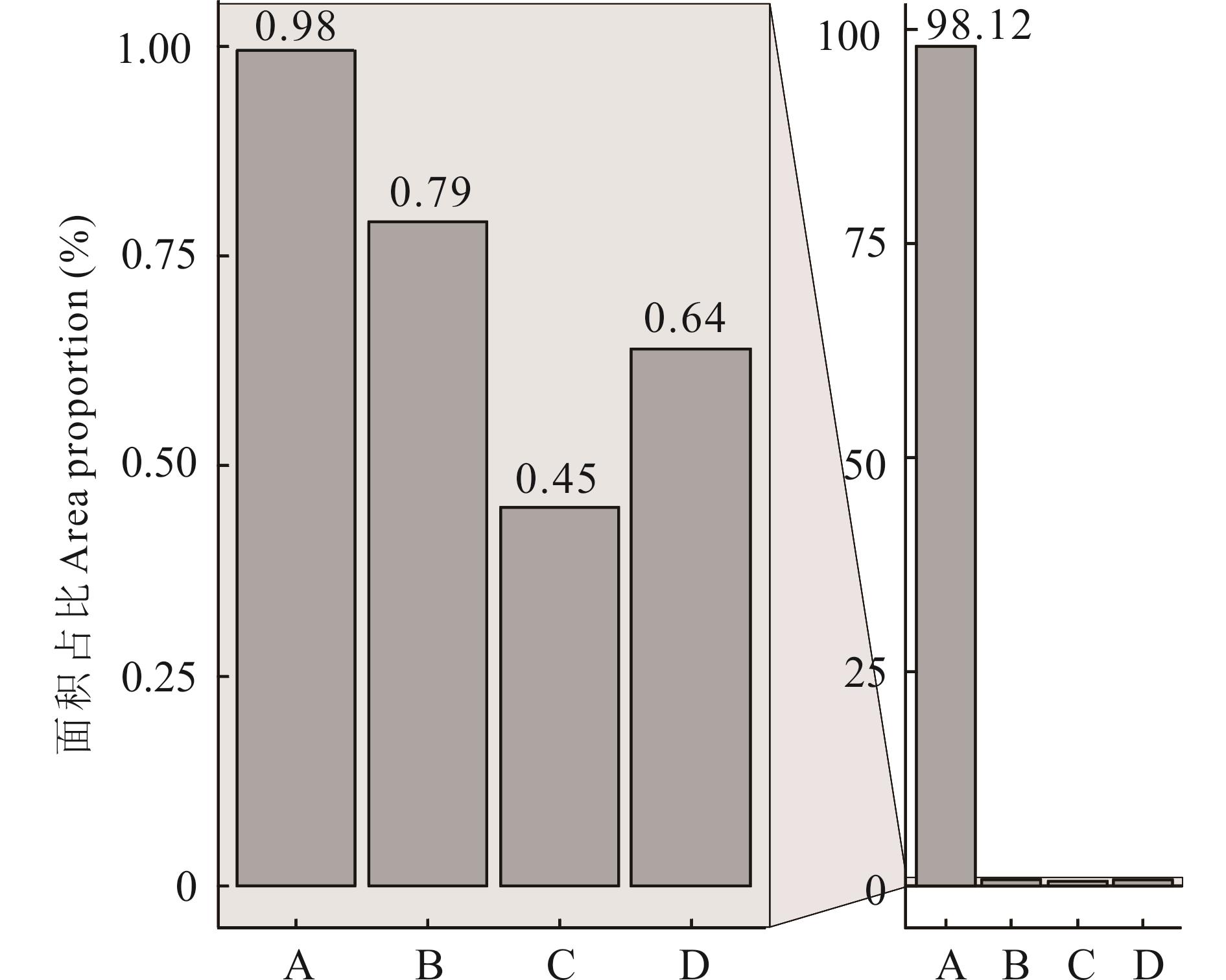
图4 山丹县草畜平衡等级面积占比A: 未超载Non-overgrazed; B: 基本平衡Balance; C: 超载Overgrazed; D: 严重超载Severe overgrazed.
Fig.4 Area proportion of forage-livestock balance grades in Shandan County

图5 山丹县草畜平衡指数空间分布(a)与面积占比(b)基于自然资源部标准地图服务网站甘S(2023)322号标准地图制作,底图边界无修改。Based on the standard map service website Gan S (2023) No.322 of the Ministry of Natural Resources, the boundary of the base map is not modified.
Fig.5 Spatial distribution of forage-livestock index (a) and area proportion (b) in Shandan County
| 村Village | CFBI |
|---|---|
| 朱湾村Zhuwan village | -10.91 |
| 中河村Zhonghe village | -10.82 |
| 上河村Shanghe village | -10.76 |
| 老军乡国有土地(羊种场)State owned land in Laojun town (Yangzhong farm) | -10.56 |
| 老军乡国有土地(羊虎口)State owned land in Laojun town (Yanghukou) | -10.47 |
| 老军乡国有土地(老军、丰城堡滩)State owned land in Laojun town (Laojun, Fengchengbaotan) | -10.45 |
| 马营村Maying village | -10.40 |
| 新墩村Xindun village | -10.39 |
| 硖口村Xiakou village | -10.38 |
| 河湾村Hewan village | -10.28 |
| 新泉村Xinquan village | -10.27 |
| 大黄山林场Dahuangshan forest farm | -10.25 |
| 前山村Qianshan village | -10.17 |
| 东山村Dongshan village | -10.15 |
| 东沟村Donggou village | -10.12 |
| 夹河村Jiahe village | -10.05 |
| 陈户镇国有土地(大沙河及黑山子)State owned land in Chenhu town (Dashahe and Heishanzi) | -10.01 |
| 老军乡国有土地(青羊口农场)State owned land in Laojun town (Qingyangkou farm) | -10.00 |
| 西沟村Xigou village | -9.96 |
| 楼庄村Louzhuang village | -9.87 |
| 羊虎沟村Yanghugou village | -9.86 |
| 郭泉村Guoquan village | -9.84 |
| 城南村Chengnan village | -9.82 |
| 窑坡村Yaopo village | -9.81 |
| 清泉镇国有土地(瞭高山)State owned land in Qingquan town (Liaogao mountains) | -9.54 |
| 下河西村Xiahexi village | -9.52 |
| 上山湾村Shangshanwan village | -9.49 |
| 老军乡国有土地(花草滩、东水泉)State owned land in Laojun town (Huacaotan and Dongshuiquan) | -9.46 |
| 沙沟村Shagou village | -9.43 |
| 刘庄村Liuzhuang village | -9.37 |
| 陈户镇国有土地(北山)State owned land in Chenhu town (Beishan) | -9.36 |
| 汪庄村Wangzhuang village | -9.35 |
| 下河村Xiahe village | -9.26 |
| 北滩村Beitan village | -9.18 |
| 上寨村Shangzhai village | -9.15 |
| 清泉镇国有土地(中牧山丹马场)State owned land in Qingquan town (Zhongmu Shandan Racecourse) | -9.09 |
| 陈户镇国有土地(陈户公滩)State owned land in Chenhu town (Chenhugongtan) | -9.08 |
| 柳荫村Liuyin village | -9.03 |
| 杨坝村Yangba village | -8.99 |
| 东关村Dongguan village | -8.96 |
| 山湾村Shanwan village | -8.96 |
| 侯山村Houshan village | -8.87 |
| 芦堡村Lubao village | -8.79 |
| 双湖村Shuanghu village | -8.78 |
| 大马营镇国有土地State owned land in Damaying town | -8.78 |
| 四坝村Siba village | -8.76 |
| 位奇镇国有土地(新开)State owned land in Weiqi town (Xinkai) | -8.73 |
| 杜庄村Duzhuang village | -8.66 |
| 新庄村Xinzhuang village | -8.64 |
| 高庙村Gaomiao village | -8.56 |
| 老军乡国有土地(焉支山)State owned land in Laojun town (Yanzhi Mountain) | -8.48 |
| 位奇村Weiqi village | -8.47 |
| 下寨村Xiazhai village | -8.46 |
| 潘庄村Panzhuang village | -8.28 |
| 位奇镇国有土地(北山)State owned land in Weiqi town (Beishan) | -8.26 |
| 巴寨村Bazhai village | -8.15 |
| 老军乡国有土地(良种场)State owned land in Laojun town (Liangzhong farm) | -7.84 |
| 周庄村Zhouzhuang village | -7.78 |
| 新开村Xinkai village | -7.68 |
| 吴宁村Wuning village | -7.67 |
| 二十里堡村Ershi village | -7.14 |
| 下西山村Xiaxishan village | -7.01 |
| 花寨村Huazhai village | -6.95 |
| 高湖村Gaohu village | -6.93 |
| 上西山村Shangxishan village | -6.66 |
| 清泉镇国有土地(北山)State owned land in Qingquan town (Beishan) | -6.51 |
| 十里堡村Shilibao village | -5.66 |
| 东乐镇国有土地(北滩)State owned land in Dongle town (Beitan) | -5.44 |
| 李泉村Liquan village | -5.43 |
| 祝庄村Zhuzhuang village | -5.24 |
| 东乐镇国有土地(山羊堡滩)State owned land in Dongle town (Shanyangbaotan) | -5.24 |
| 红寺湖村Hongsihu village | -3.72 |
表5 山丹县各行政村综合草畜平衡指数
Table 5 CFBI for each village in Shandan County
| 村Village | CFBI |
|---|---|
| 朱湾村Zhuwan village | -10.91 |
| 中河村Zhonghe village | -10.82 |
| 上河村Shanghe village | -10.76 |
| 老军乡国有土地(羊种场)State owned land in Laojun town (Yangzhong farm) | -10.56 |
| 老军乡国有土地(羊虎口)State owned land in Laojun town (Yanghukou) | -10.47 |
| 老军乡国有土地(老军、丰城堡滩)State owned land in Laojun town (Laojun, Fengchengbaotan) | -10.45 |
| 马营村Maying village | -10.40 |
| 新墩村Xindun village | -10.39 |
| 硖口村Xiakou village | -10.38 |
| 河湾村Hewan village | -10.28 |
| 新泉村Xinquan village | -10.27 |
| 大黄山林场Dahuangshan forest farm | -10.25 |
| 前山村Qianshan village | -10.17 |
| 东山村Dongshan village | -10.15 |
| 东沟村Donggou village | -10.12 |
| 夹河村Jiahe village | -10.05 |
| 陈户镇国有土地(大沙河及黑山子)State owned land in Chenhu town (Dashahe and Heishanzi) | -10.01 |
| 老军乡国有土地(青羊口农场)State owned land in Laojun town (Qingyangkou farm) | -10.00 |
| 西沟村Xigou village | -9.96 |
| 楼庄村Louzhuang village | -9.87 |
| 羊虎沟村Yanghugou village | -9.86 |
| 郭泉村Guoquan village | -9.84 |
| 城南村Chengnan village | -9.82 |
| 窑坡村Yaopo village | -9.81 |
| 清泉镇国有土地(瞭高山)State owned land in Qingquan town (Liaogao mountains) | -9.54 |
| 下河西村Xiahexi village | -9.52 |
| 上山湾村Shangshanwan village | -9.49 |
| 老军乡国有土地(花草滩、东水泉)State owned land in Laojun town (Huacaotan and Dongshuiquan) | -9.46 |
| 沙沟村Shagou village | -9.43 |
| 刘庄村Liuzhuang village | -9.37 |
| 陈户镇国有土地(北山)State owned land in Chenhu town (Beishan) | -9.36 |
| 汪庄村Wangzhuang village | -9.35 |
| 下河村Xiahe village | -9.26 |
| 北滩村Beitan village | -9.18 |
| 上寨村Shangzhai village | -9.15 |
| 清泉镇国有土地(中牧山丹马场)State owned land in Qingquan town (Zhongmu Shandan Racecourse) | -9.09 |
| 陈户镇国有土地(陈户公滩)State owned land in Chenhu town (Chenhugongtan) | -9.08 |
| 柳荫村Liuyin village | -9.03 |
| 杨坝村Yangba village | -8.99 |
| 东关村Dongguan village | -8.96 |
| 山湾村Shanwan village | -8.96 |
| 侯山村Houshan village | -8.87 |
| 芦堡村Lubao village | -8.79 |
| 双湖村Shuanghu village | -8.78 |
| 大马营镇国有土地State owned land in Damaying town | -8.78 |
| 四坝村Siba village | -8.76 |
| 位奇镇国有土地(新开)State owned land in Weiqi town (Xinkai) | -8.73 |
| 杜庄村Duzhuang village | -8.66 |
| 新庄村Xinzhuang village | -8.64 |
| 高庙村Gaomiao village | -8.56 |
| 老军乡国有土地(焉支山)State owned land in Laojun town (Yanzhi Mountain) | -8.48 |
| 位奇村Weiqi village | -8.47 |
| 下寨村Xiazhai village | -8.46 |
| 潘庄村Panzhuang village | -8.28 |
| 位奇镇国有土地(北山)State owned land in Weiqi town (Beishan) | -8.26 |
| 巴寨村Bazhai village | -8.15 |
| 老军乡国有土地(良种场)State owned land in Laojun town (Liangzhong farm) | -7.84 |
| 周庄村Zhouzhuang village | -7.78 |
| 新开村Xinkai village | -7.68 |
| 吴宁村Wuning village | -7.67 |
| 二十里堡村Ershi village | -7.14 |
| 下西山村Xiaxishan village | -7.01 |
| 花寨村Huazhai village | -6.95 |
| 高湖村Gaohu village | -6.93 |
| 上西山村Shangxishan village | -6.66 |
| 清泉镇国有土地(北山)State owned land in Qingquan town (Beishan) | -6.51 |
| 十里堡村Shilibao village | -5.66 |
| 东乐镇国有土地(北滩)State owned land in Dongle town (Beitan) | -5.44 |
| 李泉村Liquan village | -5.43 |
| 祝庄村Zhuzhuang village | -5.24 |
| 东乐镇国有土地(山羊堡滩)State owned land in Dongle town (Shanyangbaotan) | -5.24 |
| 红寺湖村Hongsihu village | -3.72 |
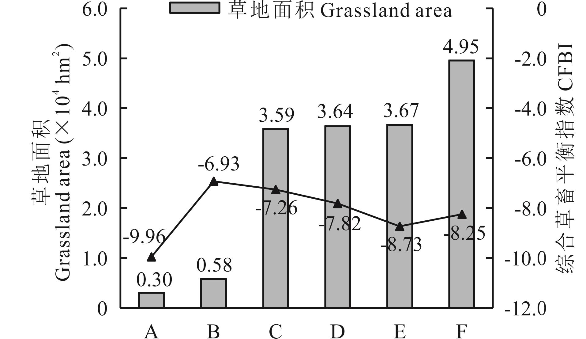
图6 山丹县不同草地类型面积及综合草畜平衡指数A: 高寒草甸Alpine meadow; B: 山地草甸Mountain meadow; C: 温性草原Temperate steppe; D: 温性草原化荒漠Temperate steppe desert; E: 温性荒漠Temperate desert; F: 温性荒漠草原Temperate desert steppe.
Fig.6 Area and CFBI of different grassland types in Shandan County
| 项目Project | 最大值Maximum value | 最小值Minimum value | 权重Weight (%) |
|---|---|---|---|
| 草地面积Grassland area (×104 hm2) | 3.50 | 0.0004 | — |
| 综合抗干扰指数Comprehensive anti-interference index | 5.57 | 1.00 | — |
| 斑块数量Number of patches | 205.00 | 1.00 | 39.08 |
| 平均斑块面积Mean patch size (hm2) | 3401.37 | 1.47 | 39.08 |
| 面积加权平均形状指数Area-weighted mean shape index | 15.37 | 1.60 | 15.08 |
| 聚集度Aggregation index | 98.81 | 67.18 | 6.74 |
| 草地细碎化综合指数Comprehensive index of grassland fragmentation | 1338.90 | 6.70 | — |
表6 各项指标描述
Table 6 Description of each indicator
| 项目Project | 最大值Maximum value | 最小值Minimum value | 权重Weight (%) |
|---|---|---|---|
| 草地面积Grassland area (×104 hm2) | 3.50 | 0.0004 | — |
| 综合抗干扰指数Comprehensive anti-interference index | 5.57 | 1.00 | — |
| 斑块数量Number of patches | 205.00 | 1.00 | 39.08 |
| 平均斑块面积Mean patch size (hm2) | 3401.37 | 1.47 | 39.08 |
| 面积加权平均形状指数Area-weighted mean shape index | 15.37 | 1.60 | 15.08 |
| 聚集度Aggregation index | 98.81 | 67.18 | 6.74 |
| 草地细碎化综合指数Comprehensive index of grassland fragmentation | 1338.90 | 6.70 | — |
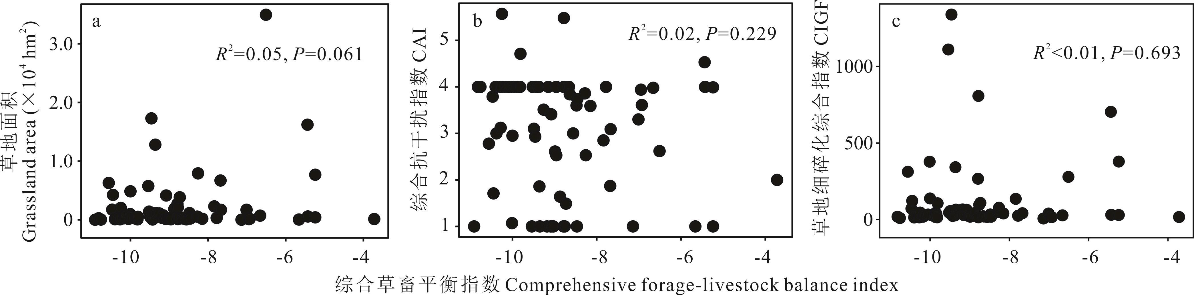
图7 各行政村的综合草畜平衡指数与草地面积、综合抗干扰指数和草地细碎化综合指数间的关系CAI: 综合抗干扰指数Comprehensive anti-interference index; CIGF: 草地细碎化综合指数Comprehensive index of grassland fragmentation.
Fig.7 The relationship between comprehensive forage-livestock balance index of each village and grassland area, CAI, CIGF
| 1 | Hu Z M, Zhao Z, Zhang Y, et al. Does ‘Forage-Livestock Balance’ policy impact ecological efficiency of grasslands in China? Journal of Cleaner Production, 2018, 207: 343-349. |
| 2 | Zhang C, Yan H M, Yao X J. Dynamic assessment of grass-livestock balance in Gannan. Journal of Natural Resources, 2022, 37(7): 1903-1917. |
| 张聪, 闫慧敏, 姚晓军. 甘南地区草畜平衡动态评估. 自然资源学报, 2022, 37(7): 1903-1917. | |
| 3 | Xu B, Yang X C, Jin Y X, et al. Monitoring and evaluation of grassland-livestock balance in pastoral and semi-pastoral counties of China. Geographical Research, 2012, 31(11): 1998-2006. |
| 徐斌, 杨秀春, 金云翔, 等. 中国草原牧区和半牧区草畜平衡状况监测与评价. 地理研究, 2012, 31(11): 1998-2006. | |
| 4 | Liu A J, Yang Y, Bo Y C, et al. Evolution of forage-livestock balance management model and progress of monitoring technology in China. Chinese Journal of Grassland, 2023, 45(12): 1-10. |
| 刘爱军, 杨勇, 柏延臣, 等. 我国草畜平衡管理模式演变与监测技术进展. 中国草地学报, 2023, 45(12): 1-10. | |
| 5 | Li W J, Jiu C L, Tan Z H, et al. Natural grassland productivity and the livestock-feeds balance in Qinghai Province. Resources Science, 2012, 34(2): 367-372. |
| 李文娟, 九次力, 谭忠厚, 等. 青海省草地生产力及草畜平衡状况研究. 资源科学, 2012, 34(2): 367-372. | |
| 6 | Liu X Y, Mu Y T. Research progress in the ecosystem services function and value of grasslands. Acta Prataculturae Sinica, 2012, 21(6): 286-295. |
| 刘兴元, 牟月亭. 草地生态系统服务功能及其价值评估研究进展. 草业学报, 2012, 21(6): 286-295. | |
| 7 | Zong X, Zhang Q L. Differentiated compensation for grass-livestock balance: Case of Ruo ergai-Gannan Yellow River water conservation area. Journal of Arid Land Resources and Environment, 2022, 36(9): 88-97. |
| 宗鑫, 张钦鲁. 差异化的草畜平衡补偿研究-以若尔盖甘南黄河水源涵养区为例. 干旱区资源与环境, 2022, 36(9): 88-97. | |
| 8 | Su D X, Yang Z, Yun X J. Calculation of reasonable stocking capacity of natural grassland, NY/T 635-2015. Beijing: Ministry of Agriculture of the People’s Republic of China, 2015. |
| 苏大学, 杨智, 贠旭疆.天然草地合理载畜量的计算, NY/T 635-2015. 北京: 中华人民共和国农业部, 2015. | |
| 9 | Huang L, Ning J, Zhu P, et al. The conservation patterns of grassland ecosystem in response to the forage-livestock balance in North China. Journal of Geographical Sciences, 2021, 31(4): 518-534. |
| 10 | Mo X G, Liu W, Meng C C, et al. Variations of forage yield and forage-livestock balance in grasslands over the Tibetan Plateau, China. Chinese Journal of Applied Ecology, 2021, 32(7): 2415-2425. |
| 莫兴国, 刘文, 孟铖铖, 等. 青藏高原草地产量与草畜平衡变化. 应用生态学报, 2021, 32(7): 2415-2425. | |
| 11 | Xu M Y. A review of grassland carrying capacity: perspective and dilemma for research in China on “forage-livestock balance”. Acta Prataculturae Sinica, 2014, 23(5): 321-329. |
| 徐敏云. 草地载畜量研究进展: 中国草畜平衡研究困境与展望. 草业学报, 2014, 23(5): 321-329. | |
| 12 | Cao Y N, Wu J S, Zhang X Z, et al. Comparison of methods for evaluating the forage-livestock balance of alpine grasslands on the Northern Tibetan Plateau. Journal of Resources and Ecology, 2020, 11(3): 272-282. |
| 13 | Meng B P, Liang T G, Yi S H, et al. Modeling alpine grassland above ground biomass based on remote sensing data and machine learning algorithm: A case study in east of the Tibetan Plateau, China. IEEE Journal of Selected Topics in Applied Earth Observations and Remote Sensing, 2020, 13: 2986-2995. |
| 14 | Zhang Y X, Huang J X, Jin Y X, et al. Estimation of grasslands aboveground biomass: A review. Acta Agrestia Sinica, 2022, 30(4): 850-858. |
| 张雨欣, 黄健熙, 金云翔, 等. 草地地上生物量估算模型研究进展. 草地学报, 2022, 30(4): 850-858. | |
| 15 | Wang J, Xiao X M, Bajgain R, et al. Estimating leaf area index and aboveground biomass of grazing pastures using Sentinel-1, Sentinel-2 and Landsat images. ISPRS Journal of Photogrammetry and Remote Sensing, 2019, 154: 189-201. |
| 16 | Qin Q, Xu D W, Hou L L, et al. Comparing vegetation indices from Sentinel-2 and Landsat 8 under different vegetation gradients based on a controlled grazing experiment. Ecological Indicators, 2021, 133: 108363. |
| 17 | Yao Y W, Ren H R. Estimation of grassland aboveground biomass on the Qinghai-Tibet Plateau. Acta Ecologica Sinica, 2024, 44(7): 3049-3059. |
| 姚雨微, 任鸿瑞. 青藏高原草地地上生物量估算研究. 生态学报, 2024, 44(7): 3049-3059. | |
| 18 | Gan C Y, Wang X Z, Li B S, et al. Changes of vegetation coverage during recent 18 years in Lianjiang River watershed. Scientia Geographica Sinica, 2011, 31(8): 1019-1024. |
| 甘春英, 王兮之, 李保生, 等. 连江流域近18年来植被覆盖度变化分析. 地理科学, 2011, 31(8): 1019-1024. | |
| 19 | Zhao Y H, Hou P, Jiang J B, et al. Progress in quantitative inversion of vegetation ecological remote sensing parameters. National Remote Sensing Bulletin, 2021, 25(11): 2173-2197. |
| 赵燕红, 侯鹏, 蒋金豹, 等. 植被生态遥感参数定量反演研究方法进展. 遥感学报, 2021, 25(11): 2173-2197. | |
| 20 | Liu X Y, Feng Q S, Liang T G, et al. Spatial-temporal dynamic balance between livestock carrying capacity and productivity of rangeland in Gannan of Gansu Province, China. Chinese Journal of Grassland, 2010, 32(1): 99-106. |
| 刘兴元, 冯琦胜, 梁天刚, 等. 甘南牧区草地生产力与载畜量时空动态平衡研究. 中国草地学报, 2010, 32(1): 99-106. | |
| 21 | Liang T G, Feng Q S, Xia W T, et al. Optimization strategy and management decision-making in balancing forage and livestock in Gannan pastoral area. Acta Ecologica Sinica, 2011, 31(4): 1111-1123. |
| 梁天刚, 冯琦胜, 夏文韬, 等. 甘南牧区草畜平衡优化方案与管理决策. 生态学报, 2011, 31(4): 1111-1123. | |
| 22 | Guo Y, Jia Z B, Zhang Q, et al. Study on the spatiotemporal dynamics of forage-livestock balance in Hulunbuir grassland of Inner Mongolia based on remote sensing data. Chinese Journal of Grassland, 2021, 43(4): 30-37. |
| 郭阳, 贾志斌, 张琪, 等. 基于遥感数据的内蒙古呼伦贝尔草原草畜平衡时空动态研究. 中国草地学报, 2021, 43(4): 30-37. | |
| 23 | Psomas A, Kneubühler M, Huber S, et al. Hyperspectral remote sensing for estimating aboveground biomass and for exploring species richness patterns of grassland habitats. International Journal of Remote Sensing, 2011, 32(24): 9007-9031. |
| 24 | Guerini F M, Kuplich T M, De Q, et al. Estimating natural grassland biomass by vegetation indices using Sentinel 2 remote sensing data. International Journal of Remote Sensing, 2020, 41(8): 2861-2876. |
| 25 | Huang J X, Wu J, Li C B, et al. Remote sensing retrieval of grassland above-ground biomass in Tianzhu County based on Sentinal-2 and Landsat 8 data. Acta Agrestia Sinica, 2021, 29(9): 2023-2030. |
| 黄家兴, 吴静, 李纯斌, 等. 基于Sentinel-2和Landsat 8数据的天祝县草地地上生物量遥感反演. 草地学报, 2021, 29(9): 2023-2030. | |
| 26 | Guo R, Fu S, Hou M J, et al. Remote sensing retrieval of nature grassland biomass in Menyuan County, Qinghai Province experimental area based on Sentinel-2 data. Acta Prataculturae Sinica, 2023, 32(4): 15-29. |
| 郭芮, 伏帅, 侯蒙京, 等. 基于Sentinel-2数据的青海门源县天然草地生物量遥感反演研究. 草业学报, 2023, 32(4): 15-29. | |
| 27 | Cao J, Zhang Y J, Li X Y, et al. Application of remote sensing technology in the study of grassland-livestock balance in Gangcha, Qinghai Province. Chinese Journal of Agricultural Resources and Regional Planning, 2020, 41(10): 138-146. |
| 曹娟, 张勇娟, 李新一, 等. 遥感技术在青海刚察县草畜平衡研究中的应用. 中国农业资源与区划, 2020, 41(10): 138-146. | |
| 28 | Zhang Y J, Cao J, Yun X J, et al. Assessment study on grassland yield and carrying capacity in Gongliu, Xinjiang based on RS, CIS, and GPS. Chinese Journal of Agricultural Resources and Regional Planning, 2020, 41(10): 156-164. |
| 张勇娟, 曹娟, 贠旭江, 等. 基于3S技术的新疆巩留县草原产草量及载畜平衡评估研究. 中国农业资源与区划, 2020, 41(10): 156-164. | |
| 29 | Chen Q G. Key pasture, seasonal grazing and sustainable development of grassland animal husbandry production in China. Acta Prataculturae Sinica, 2005, 14(4): 29-34. |
| 陈全功. 关键场与季节放牧及草地畜牧业的可持续发展. 草业学报, 2005, 14(4): 29-34. | |
| 30 | Liu H F, Hou L L, Kang N N, et al. The economic value of grassland ecosystem services: A global meta-analysis. Grassland Research, 2022, 1(1): 63-74. |
| 31 | Li Q F. Series of studies on balance control between animal demanding and feed availability(1)-Discussions and comments on the currently practiced animal-feed balance control system. Pratacultural Science, 2011, 28(10): 1869-1872. |
| 李青丰. 草畜平衡管理系列研究(1)-现行草畜平衡管理制度刍议. 草业科学, 2011, 28(10): 1869-1872. | |
| 32 | Zhang Y J, Yin G M, Liu N, et al. Evaluating criterion for balance of forage supply and livestock requirement, LY/T 3320-2022. Beijing: National Forestry and Grassland Administration, 2022. |
| 张英俊, 殷国梅, 刘楠, 等. 草畜平衡评价技术规范, LY/T 3320-2022. 北京: 国家林业和草原局, 2022. | |
| 33 | Gou X Z, Gu L R, Zhou G D. The current situation and suggestions of grassland and grassland livestock balance in pastoral areas of Gansu Province. China Feed, 2023(19): 187-192. |
| 苟想珍, 顾玲荣, 周国栋. 甘肃牧区草原草畜平衡现状及建议. 中国饲料, 2023(19): 187-192. | |
| 34 | The Zhangye Municipal Bureau of Statistics. Zhangye City national economic and social development statistical bulletin in 2022. https://www.zhangye.gov.cn/sjfb/xbtjnj/202312/t20231204_1151009.html,2023-12-04. |
| 张掖市统计局. 2022年张掖市国民经济和社会发展统计公报. https://www.zhangye.gov.cn/sjfb/xbtjnj/202312/t20231204_11 51009.html, 2023-12-04. | |
| 35 | Meng B P, Chen S Y, Cui X, et al. The accuracy of grassland vegetation biomass estimated model based on multi-source remote sensing data-As a case of experimental area in Sangke grassland in Xiahe County. Pratacultural Science, 2015, 32(11): 1730-1739. |
| 孟宝平, 陈思宇, 崔霞, 等. 基于多源遥感数据的高寒草地生物量反演模型精度—以夏河县桑科草原试验区为例. 草业科学, 2015, 32(11): 1730-1739. | |
| 36 | Zhao Y H, Hou M J, Feng Q S, et al. Estimation of aboveground biomass in Menyuan grassland based on Landsat 8 and random forest approach. Acta Prataculturae Sinica, 2022, 31(7): 1-14. |
| 赵翊含, 侯蒙京, 冯琦胜, 等. 基于Landsat 8和随机森林的青海门源天然草地地上生物量遥感估算. 草业学报, 2022, 31(7): 1-14. | |
| 37 | Ren J Z. Classfication and cluster applicable for grassland type. Acta Agrestia Sinica, 2008, 16(1): 4-10. |
| 任继周. 分类、聚类与草原类型. 草地学报, 2008, 16(1): 4-10. | |
| 38 | Tan S H. Impacts and mechanisms of grazing institutional transitions on grassland degradation. Issues in Agricultural Economy, 2020, 482(2): 115-125. |
| 谭淑豪. 牧业制度变迁对草地退化的影响及其路径. 农业经济问题, 2020, 482(2): 115-125. | |
| 39 | Yang L, Wu Y H. Research on the problems of grassland fences and fragmentation in Inner Mongolia. Forward Position, 2022, 438(4): 118-127. |
| 杨理, 乌亚罕. 内蒙古草原网围栏和草场碎片化问题研究-基于锡林郭勒盟入户调查的分析. 前沿, 2022, 438(4): 118-127. | |
| 40 | Chu L Q, Zhang Z T, Jiang Z D. How does the fragmentation of pasture affect herders’ balance between grass and livestock? Journal of Agrotechnical Economics, 2022(8): 83-96. |
| 褚力其, 张志涛, 姜志德. 草场细碎化如何影响牧户实现草畜平衡-以内蒙古与青海典型牧区为例. 农业技术经济, 2022(8): 83-96. | |
| 41 | Wang X, Xu X F. Spatiotemporal characteristics and influencing factors of landscape fragmentation of cultivated land in China. Transactions of the Chinese Society of Agricultural Engineering, 2022, 38(16): 11-20. |
| 王学, 徐晓凡. 中国耕地景观细碎度时空变化特征及其影响因素. 农业工程学报, 2022, 38(16): 11-20. | |
| 42 | Wei C G, Huang Y Z, Mu Y H, et al. Cultivated land fragmentation and guidance of land consolidation based on landscape ecology perspective-A case study of Wenshan Zhuang and Miao Autonomous Prefecture. Journal of Southwest China Normal University (Natural Science Edition), 2022, 47(9): 82-90. |
| 魏成国, 黄义忠, 牟禹恒, 等. 景观生态视角下的耕地细碎化及土地整治分区—以文山壮族苗族自治州为例. 西南师范大学学报(自然科学版), 2022, 47(9): 82-90. | |
| 43 | Du G M, Zhang Y, Zhang Y Q. The spatial pattern and influencing factors of cultivated land fragmentation in typical counties of the Northeast black soil region. Research of Agricultural Modernization, 2023, 44(5): 858-868. |
| 杜国明, 张宇, 章尤琴. 东北黑土区典型县域耕地细碎化空间格局及影响因素分析. 农业现代化研究, 2023, 44(5): 858-868. | |
| 44 | Guo S, Yang W Z, Wei M H, et al. Cultivated land fragmentation and impact factors of Qinglong Manchu autonomous county based on geographically weighted regression. Research of Soil and Water Conservation, 2017, 24(3): 264-269. |
| 郭硕, 杨伟州, 魏明欢, 等. 基于地理加权回归的青龙满族自治县耕地细碎化及影响因子分析. 水土保持研究, 2017, 24(3): 264-269. | |
| 45 | Teligeer. Analysis on the current situation of forage-livestock balance in different grassland types in Inner Mongolia-Take family ranching as an example. Hohhot: Inner Mongolia Normal University, 2021. |
| 特力格尔. 内蒙古不同草原类型草畜平衡现状分析. 呼和浩特: 内蒙古师范大学, 2021. |
| [1] | 高婕, 赵新全, 刘文亭, 杨晓霞, 张春平, 俞旸, 曹铨, 刘玉祯, 张雪, 董全民. 基于供给—消耗关系的青海省高寒草地承载力时空变化分析[J]. 草业学报, 2023, 32(5): 1-12. |
| [2] | 许开宏, 施招, 马磊超, 王平, 陈昂, 王兴, 成明, 肖粤新, 王荣谭. 基于机载激光雷达与高景一号数据的草原地上生物量反演研究[J]. 草业学报, 2023, 32(5): 40-49. |
| [3] | 张殿岱, 王雪梅, 昝梅. 基于Landsat 8 OLI影像的渭-库绿洲植被地上生物量估算[J]. 草业学报, 2021, 30(11): 1-12. |
| [4] | 姜晓群, 林哲艳, 时钰, 赵晋灵, 李昂. 美国公共放牧地管理政策演进的历史经验[J]. 草业学报, 2020, 29(11): 151-164. |
| [5] | 丁文强, 杨正荣, 马驰, 李西良, 尹燕亭, 侯向阳. 草原生态保护补助奖励政策牧民满意度及影响因素研究[J]. 草业学报, 2019, 28(4): 12-22. |
| [6] | 杨帆, 邵全琴, 郭兴健, 李愈哲, 王东亮, 张雅娴, 汪阳春, 刘纪远, 樊江文. 玛多县大型野生食草动物种群数量对草畜平衡的影响研究[J]. 草业学报, 2018, 27(7): 1-13. |
| [7] | 崔亚楠, 李少伟, 余成群, 田原, 钟志明, 武建双. 西藏天然草原生态保护补助奖励政策对农牧民家庭收入的影响[J]. 草业学报, 2017, 26(3): 22-32. |
| [8] | 张旭琛, 朱华忠, 钟华平, 程耀东, 靳瑰丽, 邵小明. 新疆伊犁地区草地植被地上生物量遥感反演[J]. 草业学报, 2015, 24(6): 25-34. |
| [9] | 徐敏云. 草地载畜量研究进展:中国草畜平衡研究困境与展望[J]. 草业学报, 2014, 23(5): 321-329. |
| [10] | 杨博,吴建平,杨联,David Kemp, 宫旭胤,Taro Takahashi,冯明廷. 中国北方草原草畜代谢能平衡分析与对策研究[J]. 草业学报, 2012, 21(2): 187-195. |
| 阅读次数 | ||||||
|
全文 |
|
|||||
|
摘要 |
|
|||||