
ISSN 1004-5759 CN 62-1105/S
Acta Prataculturae Sinica ›› 2022, Vol. 31 ›› Issue (3): 1-15.DOI: 10.11686/cyxb2020573
Jie SHEN1( ), Lei DING1, Xiao-ping XIN1(), Xiang ZHANG1,2, Da-wei XU1, Lu-lu HOU1, Rui-rui YAN1
Received:2020-12-23
Revised:2021-03-01
Online:2022-03-20
Published:2022-01-15
Contact:
Xiao-ping XIN
Jie SHEN, Lei DING, Xiao-ping XIN, Xiang ZHANG, Da-wei XU, Lu-lu HOU, Rui-rui YAN. Canopy scale characteristics of grassland under different grazing intensities based on UAV lidar and multispectral data[J]. Acta Prataculturae Sinica, 2022, 31(3): 1-15.

Fig.1 Location and overview of the experimental area

Fig.2 Research plot section sampling example and control profile data example
植被参数 Vegetation parameter | 数据产品 Data product | 分辨率 Resolution (m) | 获取时间Time (年-月-日 Year-month-day) |
|---|---|---|---|
| CH | HS-600无人机激光扫描系统CH产品 CH products of HS-600 UAV laser scanning system | 0.2 | 2018-09-11 |
| FVC | HS-600无人机激光扫描系统FVC产品 Fractional vegetation cover products of HS-600 UAV laser scanning system | 0.2 | 2018-09-11 |
| NDVI | 搭载MicaSense Red Edge-MX传感器Sense Fly无人机多光谱影像 Multispectral image of Sense Fly UAV with MicaSense Red Edge-MX sensor | 0.1 | 2018-09-11 |
Table 1 Research data sources
植被参数 Vegetation parameter | 数据产品 Data product | 分辨率 Resolution (m) | 获取时间Time (年-月-日 Year-month-day) |
|---|---|---|---|
| CH | HS-600无人机激光扫描系统CH产品 CH products of HS-600 UAV laser scanning system | 0.2 | 2018-09-11 |
| FVC | HS-600无人机激光扫描系统FVC产品 Fractional vegetation cover products of HS-600 UAV laser scanning system | 0.2 | 2018-09-11 |
| NDVI | 搭载MicaSense Red Edge-MX传感器Sense Fly无人机多光谱影像 Multispectral image of Sense Fly UAV with MicaSense Red Edge-MX sensor | 0.1 | 2018-09-11 |
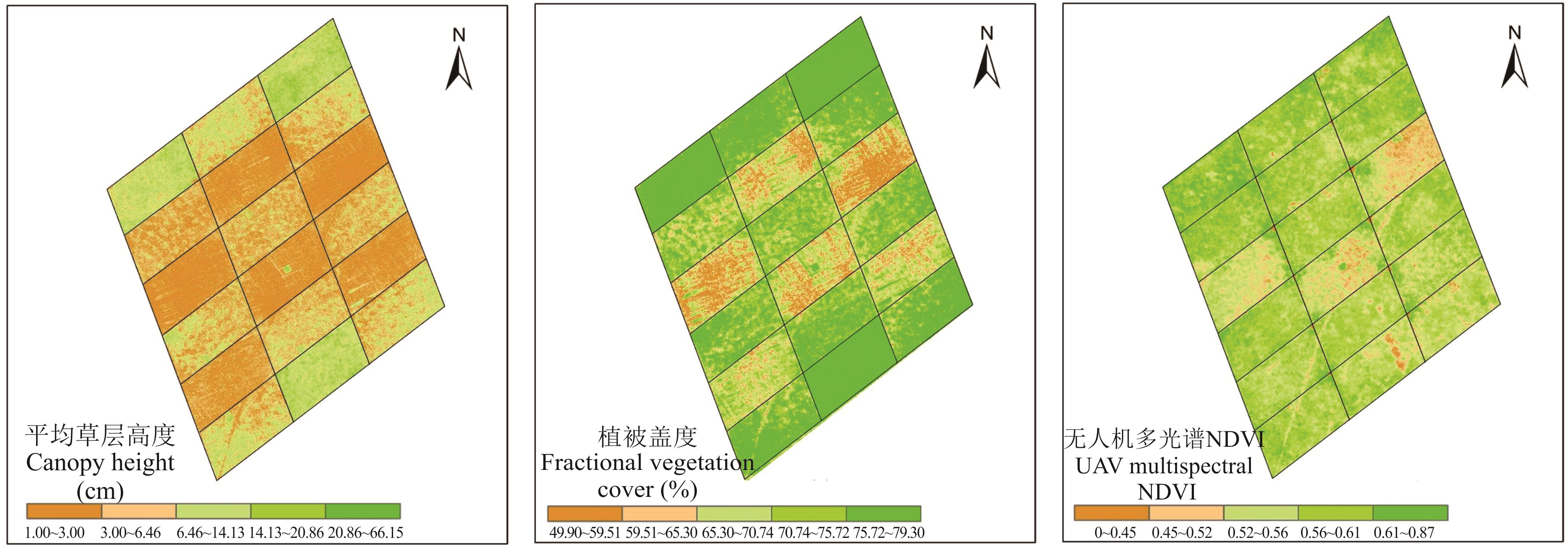
Fig.3 UAV lidar estimates
植被参数 Vegetation parameter | 项目 Item | 放牧强度 Grazing intensity | |||
|---|---|---|---|---|---|
| GI0 | GI1 | GI3 | GI5 | ||
| CH (cm) | 均值Mean | 10.6136 | 6.6287 | 4.4974 | 2.4724 |
| 标准差Standard deviation | 4.9968 | 3.5149 | 2.5772 | 1.0140 | |
| FVC (%) | 均值Mean | 78.6755 | 76.2432 | 72.1455 | 61.7160 |
| 标准差Standard deviation | 0.8188 | 3.6008 | 4.7962 | 5.7201 | |
| NDVI | 均值Mean | 0.5731 | 0.5617 | 0.5699 | 0.5184 |
| 标准差Standard deviation | 0.5040 | 0.3990 | 0.3700 | 0.4460 | |
Table 2 Mean and standard deviation of CH, FVC and NDVI under different grazing intensities
植被参数 Vegetation parameter | 项目 Item | 放牧强度 Grazing intensity | |||
|---|---|---|---|---|---|
| GI0 | GI1 | GI3 | GI5 | ||
| CH (cm) | 均值Mean | 10.6136 | 6.6287 | 4.4974 | 2.4724 |
| 标准差Standard deviation | 4.9968 | 3.5149 | 2.5772 | 1.0140 | |
| FVC (%) | 均值Mean | 78.6755 | 76.2432 | 72.1455 | 61.7160 |
| 标准差Standard deviation | 0.8188 | 3.6008 | 4.7962 | 5.7201 | |
| NDVI | 均值Mean | 0.5731 | 0.5617 | 0.5699 | 0.5184 |
| 标准差Standard deviation | 0.5040 | 0.3990 | 0.3700 | 0.4460 | |
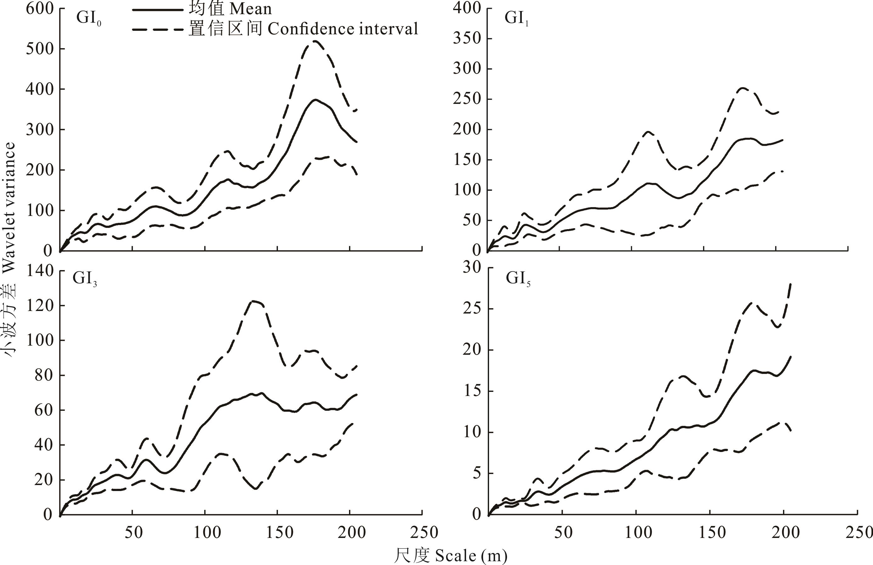
Fig.4 Mean variance and confidence interval of CH wavelet under different grazing intensities
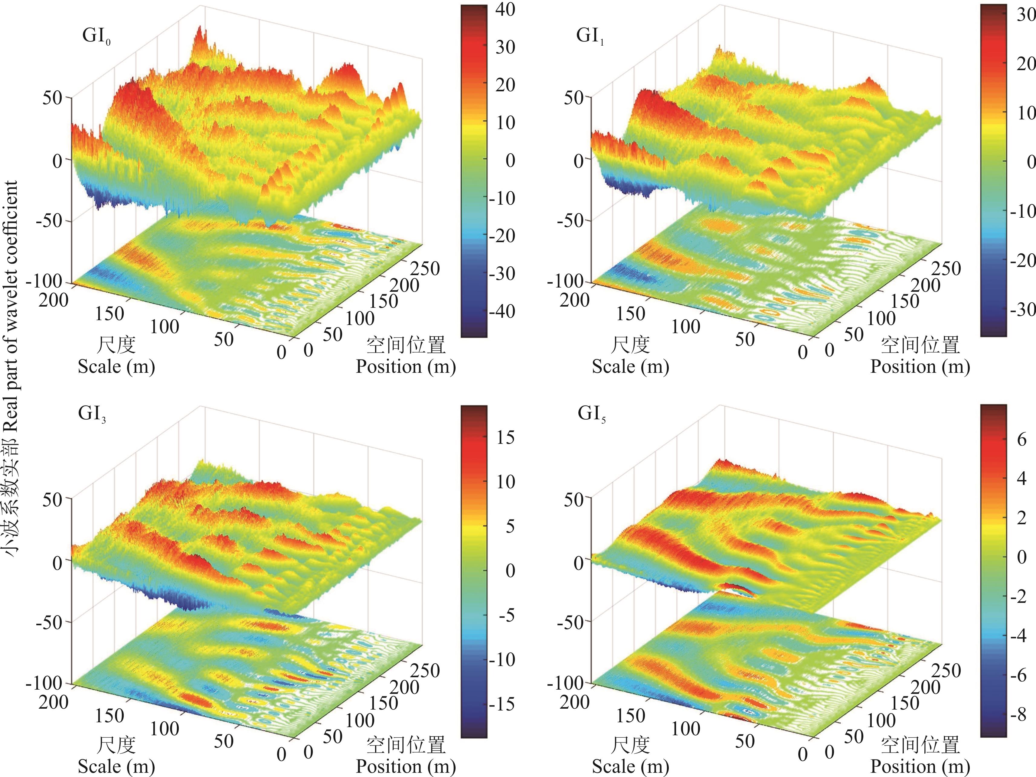
Fig.5 Real part of wavelet coefficients of CH under different grazing intensities

Fig.6 Mean variance and confidence interval of FVC wavelet under different grazing intensities
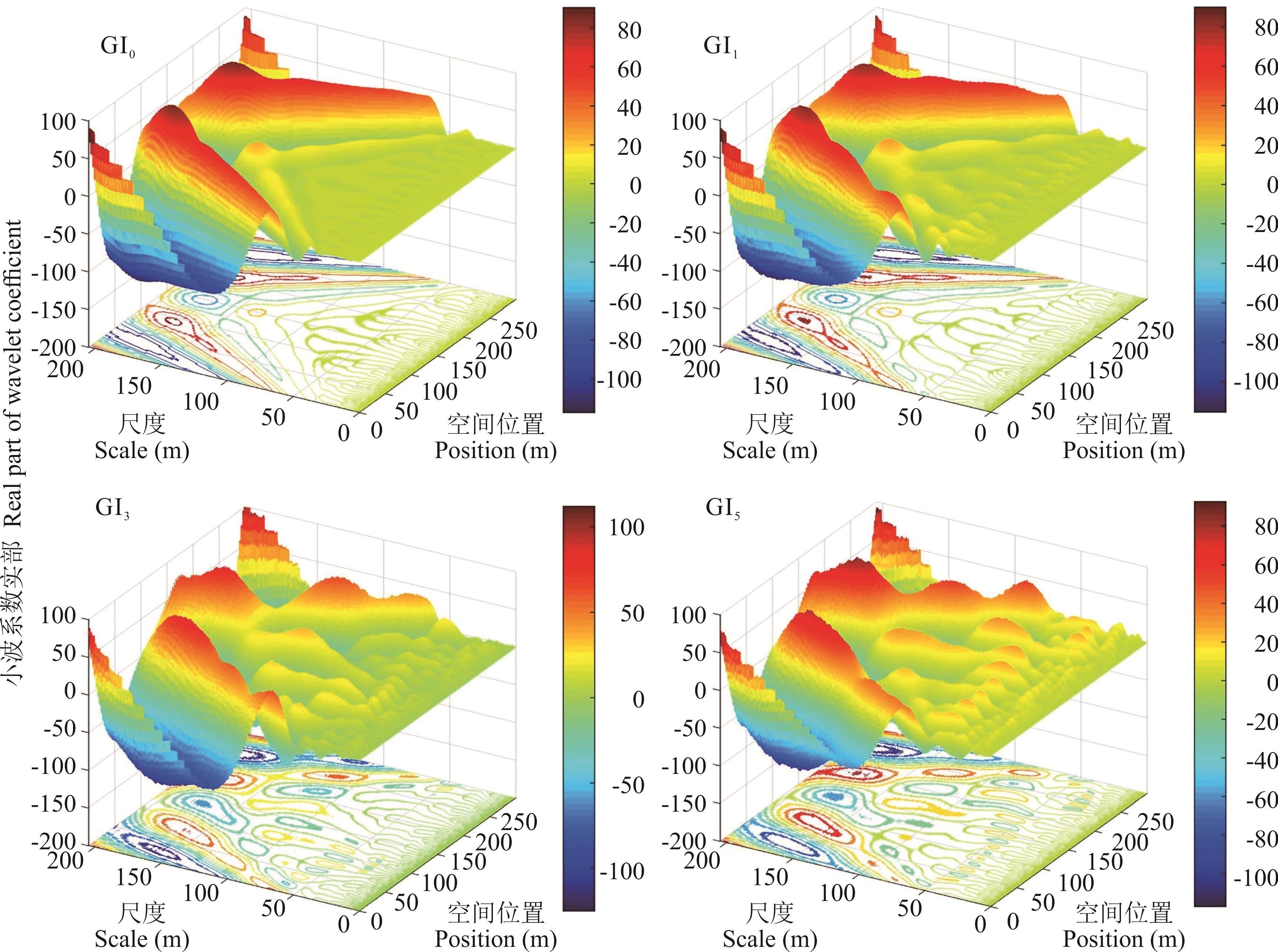
Fig.7 Real part of FVC wavelet coefficients under different grazing intensities
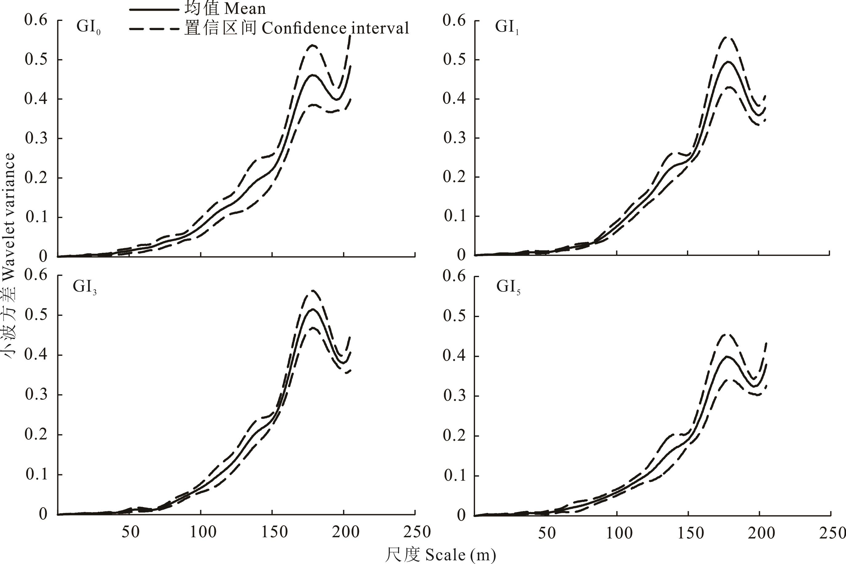
Fig.8 Mean variance and confidence interval of NDVI wavelet under different grazing intensities

Fig.9 Real part of NDVI wavelet coefficients under different grazing intensities
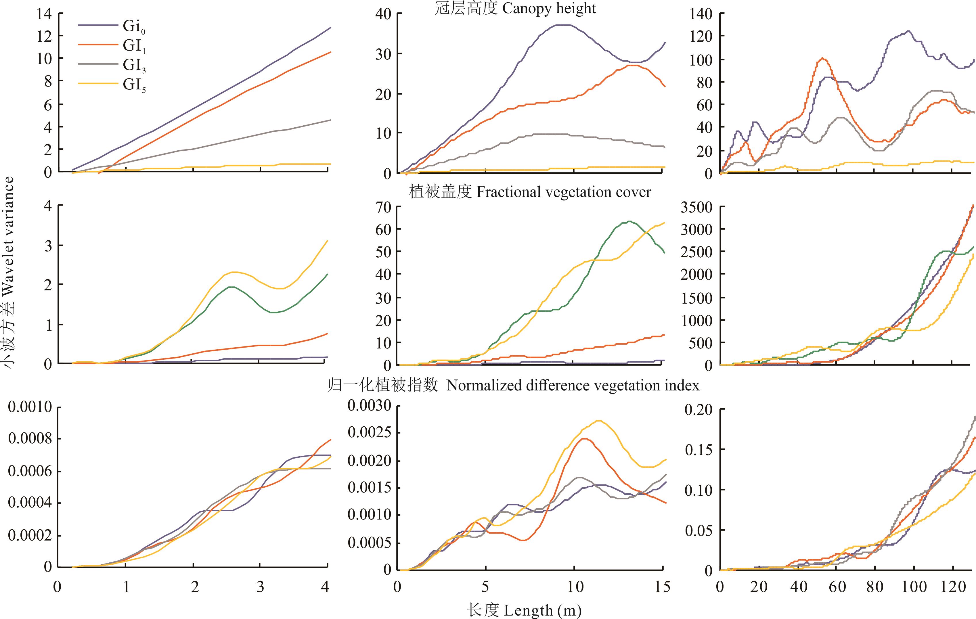
Fig.10 Wavelet variance of grassland canopy height (CH), fractional vegetation coverage (FVC) and normalized difference vegetation index (NDVI) under different grazing intensities in the three scales
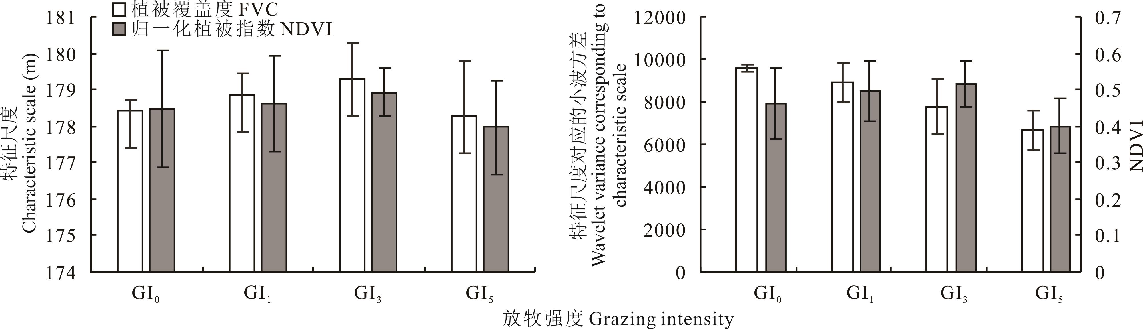
Fig.11 Mean values of the the first principal characteristic scale and the wavelet variance corresponding to the first principal characteristic scale under different grazing intensities of FVC and NDVI
| 1 | Fang J Y, Piao S L, Tang Z Y, et al. Interannual variability in net primary production and precipitation. Science, 2001, 293: 1723. |
| 2 | Bai Y, Han X, Wu J, et al. Ecosystem stability and compensatory effects in the Inner Mongolia grassland. Nature, 2004, 431: 181-184. |
| 3 | Zhang F, Chen D L, Zhao M L, et al. Effects of grazing intensity on spatial heterogeneity of the constructive species Stipa breviflora in desert steppe. Chinese Journal of Applied Ecology, 2019, 30(9): 3046-3056. |
| 张峰, 陈大岭, 赵萌莉, 等. 放牧强度对荒漠草原建群种短花针茅空间异质性的影响. 应用生态学报, 2019, 30(9): 3046-3056 . | |
| 4 | Tan H Y, Yan R R, Yan Y C, et al. Phospholipid fatty acid analysis of soil microbial communities under different grazing intensities in meadow steppe. Acta Prataculturae Sinica, 2015, 24(3):115-121. |
| 谭红妍, 闫瑞瑞, 闫玉春, 等.不同放牧强度下温性草甸草原土壤微生物群落结构PLFAS分析. 草业学报, 2015, 24(3): 115-121. | |
| 5 | Ren J Z. The scientific research method of grass industry. Beijing: China Agriculture Press, 1998. |
| 任继周. 草业科学研究方法. 北京: 中国农业出版社, 1998. | |
| 6 | Li J H, Li Z Q, Ren J Z. The effect of grazing on grassland plants. Acta Prataculturae Sinica, 2002(1): 4-11. |
| 李金花, 李镇清, 任继周. 放牧对草原植物的影响. 草业学报, 2002(1): 4-11. | |
| 7 | Wu J G. The key research topics in landscape ecology. Acta Ecologica Sinica, 2004, 24(9): 2074-2076. |
| 邬建国. 景观生态学中的十大研究论题. 生态学报, 2004(9): 2074-2076. | |
| 8 | Wu J G. Landscape ecology-concepts and theories. Chinese Journal of Ecology, 2000, 19(1): 42-52. |
| 邬建国. 景观生态学——概念与理论. 生态学杂志, 2000, 19(1): 42-52. | |
| 9 | Legendre P, Fortin M J. Spatial pattern and ecological analysis. Plant Ecology, 1989, 80(2):107-138. |
| 10 | Wang Z Q, Wang Q C, Li H B. Characteristics and comparison of spatial heterogeneity of the main species of Korean pine in old growth forests. Chinese Journal of Plant Ecology, 2000(6): 718-723. |
| 王政权, 王庆成, 李哈滨. 红松老龄林主要树种的空间异质性特征与比较的定量研究. 植物生态学报, 2000(6): 718-723. | |
| 11 | Li X M. Research on the spatial scale of eco-environment based on wavelet transform. Fuzhou: Fujian Normal University, 2008. |
| 李小梅. 基于小波变换的生态环境空间尺度研究. 福州: 福建师范大学, 2008. | |
| 12 | Simon H A. The organization of complex systems//In: Pattee H H, ed. Hierarchy theory: The challenge of complex systems. New York: George Braziller, 1973: 1-27. |
| 13 | Wu J. Hierarchy and scaling: Extrapolating information along a scaling ladder. Canadian Journal of Remote Sensing, 1999, 25: 367-380. |
| 14 | O’Neill R V. Recent developments in ecological theory: Hierarchy and scale//Scott J M, Tear T H, Davis F W, ed. GAP analysis: A landscape approach to biodiversity planning. Bethseda: American society explicit hierarchical approach to modeling complex ecological systems: Theory and applications. Ecological Modeling, 2002, 153: 7-26. |
| 15 | Robinson W S. Ecological correlations and the behavior of individuals. International Journal of Epidemiology, 1950, 15(3):351-357. |
| 16 | McCarthy H H, Hook J C, Knos D S. The measurement of association in industrial geography. Iowa: State University of Iowa, 1956. |
| 17 | Alker H R. A typology of ecological fallacies//Dogan M, Rokkan S. Quantitative ecological analysis. Cambridge: Massachusetts Institute of Technology, 1969: 69-86. |
| 18 | National Research Council. Rediscovering geography: New relevance for science and society. Washington, DC: National Academies Press, 1997. |
| 19 | Cai Y L, Lu D D, Zhou Y X, et al. Progress and international trend of geographical sciences in China. Acta Geographica Sinica, 2004(6): 803-810. |
| 蔡运龙, 陆大道, 周一星, 等. 地理科学的中国进展与国际趋势. 地理学报, 2004(6): 803-810. | |
| 20 | Li X W. Retrospect, prospect and innovation in quantitative remote sensing. Journal of Henan University (Natural Science Edition), 2005(4): 49-56. |
| 李小文. 定量遥感的发展与创新. 河南大学学报(自然科学版), 2005(4): 49-56. | |
| 21 | Qiu Y, Fu B J . Spatial variation and scale variation in soil and water loss in heterogeneous landscape: A review. Acta Ecologica Sinica, 2004, 24(2): 330-337. |
| 邱扬, 傅伯杰. 异质景观中水土流失的空间变异与尺度变异. 生态学报, 2004, 24(2): 330-337. | |
| 22 | Lv Y H, Fu B J . Ecological scale and scaling. Acta Ecologica Sinica, 2001, 21(12): 2096-2105. |
| 吕一河, 傅伯杰. 生态学中的尺度及尺度转换方法. 生态学报, 2001, 21(12): 2096-2105. | |
| 23 | Xie J B, Liu T, Wei P, et al. Ecological application of wavelet analysis in the scaling of spatial distribution patterns of Ceratoides ewersmanniana. Acta Ecologica Sinica, 2007, 27(7): 2704-2714. |
| 谢江波, 刘彤, 魏鹏, 等.小波分析方法在心叶驼绒藜(Ceratoides ewersmanniana)空间格局尺度推绎研究中的应用. 生态学报, 2007, 27(7):2704-2714. | |
| 24 | Lian J L. Applications of wavelet multi-resolution analysis. Fuzhou: Fujian Normal University, 2008. |
| 连江龙. 小波多尺度分析的应用研究. 福州: 福建师范大学, 2008. | |
| 25 | Gulinck H, Dufourmont H, Coppin P. Landscape research, landscape policy and earth observation. International Journal of Remote Sensing, 2000, 21(13): 2541-2554. |
| 26 | Sun D F. Identifying multi-scale spatial patterns of landscape from wavelet and semivariogram analysis of IKONOS PAN remote sensing data. Acta Ecologica Sinica, 2003(3): 405-413. |
| 孙丹峰. IKONOS影像景观格局特征尺度的小波与半方差分析. 生态学报, 2003(3): 405-413. | |
| 27 | Zhang P L. Effect of grazing intensity on characteristics of vegetation communities in the alpine meadow steppe. Xianyang: Northwest Agriculture & Forestry University, 2013. |
| 张鹏莉. 放牧对青藏高原草地植被群落结构特征的影响. 咸阳: 西北农林科技大学, 2013. | |
| 28 | Li L F, Shao Q M. Processing of the laser radar point cloud data based on the Terrasolid software. Urban Geotechnical Investigation & Surveying, 2013(5): 67-70. |
| 李莲芳, 邵秋铭. 基于Terrasolid软件的激光雷达点云数据处理. 城市勘测, 2013(5): 67-70. | |
| 29 | Jia K, Yao Y J, Wei X Q, et al. A review on fractional vegetation cover estimation using remote sensing. Advances in Earth Science, 2013, 28(7): 774-782. |
| 贾坤, 姚云军, 魏香琴, 等. 植被覆盖度遥感估算研究进展. 地球科学进展, 2013, 28(7): 774-782. | |
| 30 | Cao B X, Huang J F. Research on comparison and application of LIDAR point cloud data processing software. Mine Surveying, 2019, 47(1): 109-112. |
| 曹炳霞, 黄剑飞. 激光雷达点云数据处理软件对比及其应用研究. 矿山测量, 2019, 47(1): 109-112. | |
| 31 | Shi J Q, Shi Z L. Study on the application of TerraScan to filtering LiDAR data cloud. Journal of Huaihai Institute of Technology (Natural Science Edition), 2011(3): 51-54. |
| 史建青, 史照良. TerraScan在LiDAR点云滤波中的应用研究. 淮海工学院学报(自然科学版), 2011(3): 51-54. | |
| 32 | Wang D L, Xin X P, Shao Q Q, et al. Modeling aboveground biomass in Hulunber grassland ecosystem by using unmanned aerial vehicle discrete lidar.Sensors (Basel, Switzerland), 2017, 17(1): http://med.wanfangdata.com.cn/Paper/Detail/PeriodicalPaper_PM28106819. |
| 33 | Zhang X. Research on vegetation biomass inversion based on UAV LIDAR and multispectral data. Hohhot: Inner Mongolia Normal University, 2020. |
| 张翔. 基于无人机激光雷达和多光谱数据的植被生物量反演研究. 呼和浩特: 内蒙古师范大学, 2020. | |
| 34 | Luo G K. A study on Morlet wavelet transform theory and application with software implementation. Nanjing: Nanjing University of Aeronautics and Astronautics, 2007. |
| 罗光坤. Morlet小波变换理论与应用研究及软件实现. 南京: 南京航空航天大学, 2007. | |
| 35 | Hou L L, Yan R R, Zhang Y, et al. Effects of grazing intensity on functional traits of Leymus chinensis in meadow steppe. Chinese Journal of Agricultural Sciences, 2020, 53(13): 2562-2572. |
| 侯路路, 闫瑞瑞, 张宇, 等. 放牧强度对草甸草原羊草功能性状的影响. 中国农业科学, 2020, 53(13): 2562-2572. | |
| 36 | Xin X P, Yang Z Y, Tian X Z, et al. Patch dynamics of alkaline Leymus chinensis grassland under grazed and ungrazed conditions. Acta Phytoecologica Sinica, 2000(6): 656-661. |
| 辛晓平, 杨正宇, 田新智, 等. 放牧和围封条件下羊草碱化草地中斑块分布格局研究. 植物生态学报, 2000(6): 656-661. | |
| 37 | Zhang C X, Nan Z B. Research progress on effects of grazing on physical and chemical characteristics of grassland soil. Acta Prataculturae Sinica, 2010, 19(4): 204-211. |
| 张成霞, 南志标. 放牧对草地土壤理化特性影响的研究进展. 草业学报, 2010, 19(4): 204-211. | |
| 38 | Liu J X, Gong Y B, Zuo Q, et al. A review of mountain grazing-paths and vegetation spatial heterogeneity. Acta Prataculturae Sinica, 2012, 21(1): 254-261. |
| 刘金鑫, 宫渊波, 左琴, 等. 山地牧道与植被空间异质性研究评述. 草业学报, 2012, 21(1): 254-261. | |
| 39 | Garcia F, Carrère P, Soussana J F, et al. Characterisation by fractal analysis of foraging paths of ewes grazing heterogeneous swards. Applied Animal Behaviour Science, 2005, 93(1/2):19-37. |
| 40 | Garcia F, Carrère P, Soussana J F, et al. The ability of sheep at different stocking rates to maintain the quality and quantity of their diet during the grazing season. Journal of Agricultural Science, 2003, 140(1): 113-124. |
| 41 | Morton J D, Baird D B. Spatial distribution of dung patches under sheep grazing. New Zealand Journal of Agricultural Research, 1990, 33(2): 285-294. |
| 42 | Yan R R, Xin X P, Zhang B H, et al. Influence of cattle grazing gradient on plant community characteristics in Hulunber meadow steppe. Chinese Journal of Grassland, 2010, 32(3): 62-67. |
| 闫瑞瑞, 辛晓平, 张保辉, 等. 肉牛放牧梯度对呼伦贝尔草甸草原植物群落特征的影响. 中国草地学报, 2010, 32(3): 62-67. |
| [1] | Yu-xin QIAO, Hua-ping ZHONG, Hua-zhong ZHU, Xiao-ming SHAO, Yu-zhe Li. Stratified data reconstruction based on spatial pattern of soil bulk density intemperate grasslands of Northern China [J]. Acta Prataculturae Sinica, 2021, 30(1): 1-11. |
| [2] | SUN Shi-xian, DING Yong, LI Xia-zi, WU Xin-hong, YAN Zhi-jian, YIN Qiang, LI Jin-zhuo. Effects of seasonal regulation of grazing intensity on soil erosion in desert steppe grassland [J]. Acta Prataculturae Sinica, 2020, 29(7): 23-29. |
| [3] | ZHANG Yong, YANG Zi-hui, GUO Shu-jiang, WANG Qiang-qiang, ZHAN Ke-jie, ZHANG Jian-hui, WEI Huai-dong. Ecological changes in the Minqin oasis belt over the past 20 years [J]. Acta Prataculturae Sinica, 2018, 27(7): 14-24. |
| [4] | CHANG Jing-jing, XU Li, XUE Jing-yue, YANG Hao, HE Nian-peng, ZHANG Jin-jing. Effects of grazing intensity on soil organic matter and microorganisms in the Zoige alpine meadow [J]. Acta Prataculturae Sinica, 2018, 27(1): 22-31. |
| [5] | WANG Meng-Jia, SUN Rui, LIU Zhe, XIN Xiao-Ping, LIU Gang, ZHANG Lei, QIAO Chen. A study of grazing intensity in the Hulunbuir grasslands using remote sensing [J]. Acta Prataculturae Sinica, 2017, 26(6): 28-36. |
| [6] | BAO Gen-Sheng, WANG Hong-Sheng, WANG Yu-Qin, ZENG Hui, MA Ge-Liang, LUO Zang-Ang-Mao. Effects of plateau zokor burrowing activity on soil nutrient spatial heterogeneity in alpine grassland [J]. Acta Prataculturae Sinica, 2016, 25(7): 95-104. |
| [7] | QIAO Yu-Xin, ZHU Hua-Zhong, ZHONG Hua-Ping, WU Zhao-Wen, MENG Lei, ZHOU Li-Lei. Spatial interpolation analysis of grassland below-ground biomass in the Inner Mongolia Autonomous Region, China [J]. Acta Prataculturae Sinica, 2016, 25(6): 1-12. |
| [8] | CHU Bin, HUA Li-Min, ZHOU Yan-Shan, LIU Li, LI Shuai. A study of habitat selection by plateau zokor in paddocks with different grazing intensities in the eastern Qilian Mountain region [J]. Acta Prataculturae Sinica, 2016, 25(1): 179-186. |
| [9] | YUAN Zhi-Hui, BAO Gang, YIN Shan, LEI Jun, BAO Yu-Hai, SA Chu-La. Vegetation changes in Otindag sand country during 2000-2014 [J]. Acta Prataculturae Sinica, 2016, 25(1): 33-46. |
| [10] | ZHOU Li-Lei, ZHU Hua-Zhong, ZHONG Hua-Ping, YANG Hua, SUO Fei-Ya, SHAO Xiao-Ming, ZHOU Xing-Jie. Spatial analysis of soil bulk density in Yili, Xinjiang Uygur Autonomous Region, China [J]. Acta Prataculturae Sinica, 2016, 25(1): 64-75. |
| [11] | MIAO Fu-Hong, XUE Ran, GUO Zheng-Gang, SHEN Yu-Ying. Influence of yak grazing on plant niche characteristics in alpine meadow communities at the northeastern edge of the Qinghai-Tibetan Plateau [J]. Acta Prataculturae Sinica, 2016, 25(1): 88-97. |
| [12] | CHEN Zhao, LIANG Xin-Ping, HOU Fu-Jiang, TIAN Miao-Miao, ZHANG Hong-Rui, YU Ying, GUAN Yong-Zhuo, WANG Cheng-Zhang, YAN Xue-Bing. Genetic diversity of Elymus nutans under different grazing intensities [J]. Acta Prataculturae Sinica, 2015, 24(8): 159-165. |
| [13] | TAN Hongyan, YAN Ruirui, YAN Yuchun, CHEN Baorui, XIN Xiaoping. Phospholipid fatty acid analysis of soil microbial communities under different grazing intensities in meadow steppe [J]. Acta Prataculturae Sinica, 2015, 24(3): 115-121. |
| [14] | CHAI Hua,FANG Jiang-ping,WEN Ding,LI Jie,HE Nian-peng. Effect of sampling method on the estimation of soil carbon and nitrogen storages in thicketed semiarid grasslands, Inner Mongolia [J]. Acta Prataculturae Sinica, 2014, 23(6): 28-35. |
| [15] | ZHANG Ting, WENG Yue, YAO Feng-jiao, SHI Yin-tao, CUI Guo-wen, HU Guo-fu. Effect of grazing intensity on ecological stoichiometry of Deyeuxia angustifolia and meadow soil [J]. Acta Prataculturae Sinica, 2014, 23(2): 20-28. |
| Viewed | ||||||
|
Full text |
|
|||||
|
Abstract |
|
|||||