

ISSN 1004-5759 CN 62-1105/S
草业学报 ›› 2022, Vol. 31 ›› Issue (4): 165-176.DOI: 10.11686/cyxb2021057
• 研究论文 • 上一篇
花蕊1( ), 周睿1,2, 包达尔罕1, 董克池1, 唐庄生1, 花立民1()
收稿日期:2021-02-08
修回日期:2021-04-01
出版日期:2022-04-20
发布日期:2022-01-25
通讯作者:
花立民
作者简介:Corresponding author. E-mail: hualm@gsau.edu.cn基金资助:
Rui HUA1(), Rui ZHOU1,2, Daerhan BAO1, Ke-chi DONG1, Zhuang-sheng TANG1, Li-min HUA1()
Received:2021-02-08
Revised:2021-04-01
Online:2022-04-20
Published:2022-01-25
Contact:
Li-min HUA
摘要:
高原鼠兔是青藏高原特有的小型啮齿动物,是高寒草地生态系统的关键种。科学合理防控高原鼠兔危害,对其危害程度开展监测和评价十分必要。通过无人机空中遥感平台并结合地面调查,以甘肃省玛曲县高原鼠兔危害草地为研究对象,选择不同危害程度的典型样地,采用自主设计的软件提取无人机影像中高原鼠兔洞口数、地上生物量、草地盖度等指标;构建了由洞口数、地上生物量、盖度和可食牧草比例组成的高原鼠兔危害等级综合指标体系,并对研究区样地进行危害等级划分。最终形成一套适用于高原鼠兔危害的低空遥感监测方法,可为后期高效、准确监测高原鼠兔危害提供有力的技术支持。主要结果如下:1)经实地人工调查结果验证,无人机影像洞口数量和植被盖度解译精度分别达到95%和93%。2)筛选了可见光波段差值植被指数VDVI作为估测地上生物量的最佳植被指数,并构建了估测模型。经实地调查验证平均精度为86.54%。3)构建了综合危害指数DRI,并提出了划分危害级别的各指标量化值。通过聚类分析将研究区鼠害地划分为5个等级,即I-无危害草地,Ⅱ-轻度危害草地,Ⅲ-中度危害草地,Ⅳ-重度危害草地,V-极度危害草地。
花蕊, 周睿, 包达尔罕, 董克池, 唐庄生, 花立民. 基于旋翼无人机低空遥感的高原鼠兔危害等级划分技术研究[J]. 草业学报, 2022, 31(4): 165-176.
Rui HUA, Rui ZHOU, Daerhan BAO, Ke-chi DONG, Zhuang-sheng TANG, Li-min HUA. A study of UAV remote sensing technology for classifying the level of plateau pika damage to alpine rangeland[J]. Acta Prataculturae Sinica, 2022, 31(4): 165-176.
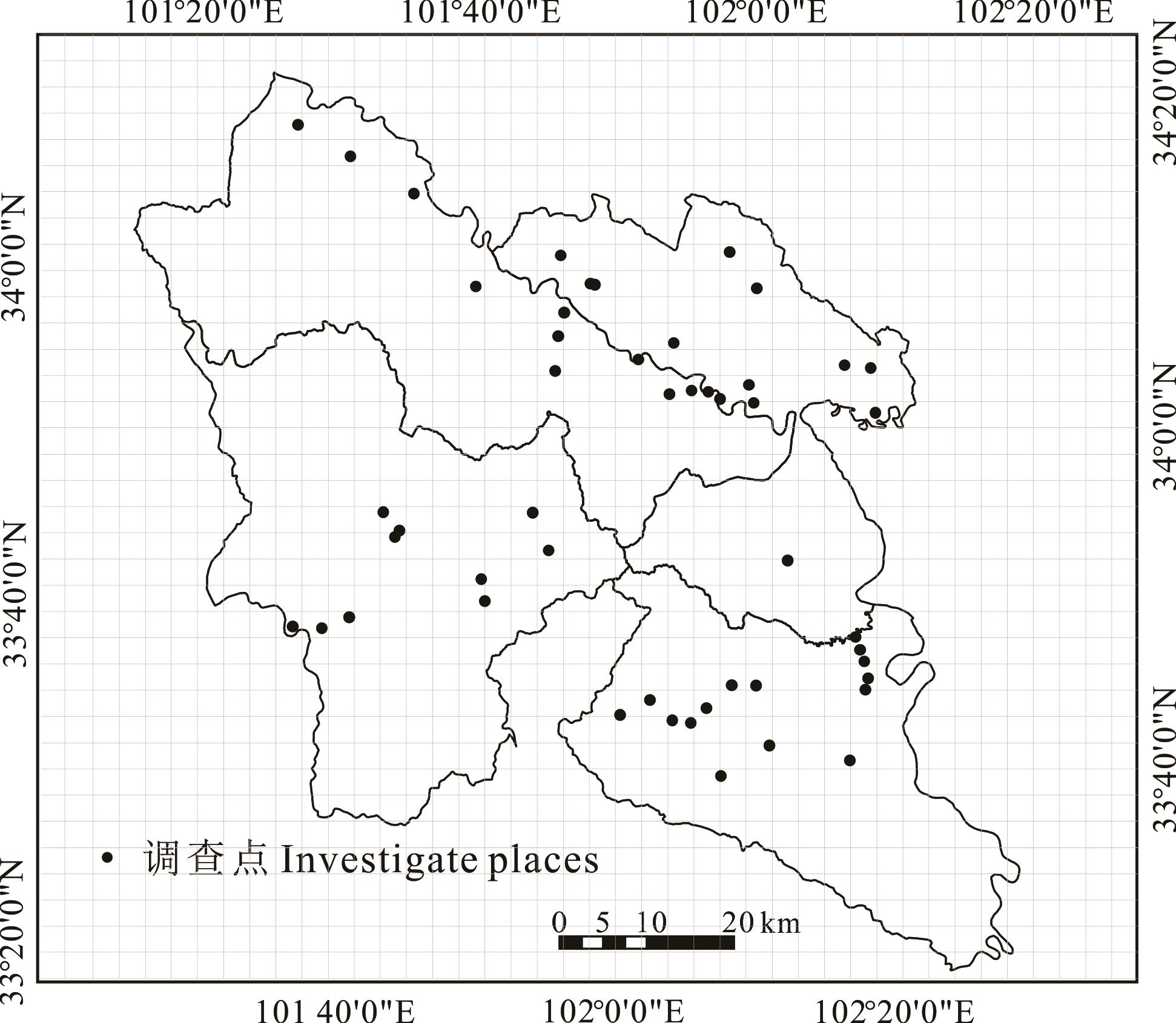
图1 高原鼠兔调查取样点
Fig.1 Sampling sites of plateau pika in Maqu county

图2 各植被指数计算结果第1列为无人机照片,其余为不同植被指数计算图The first column is UAV photos, and the rest are different vegetation index maps; VDVI: 可见光波段差值植被指数Visible-band difference vegetation index; NGRDI: 归一化绿红差值指数Normalized green-red difference index; NGBDI: 归一化绿蓝差值指数Normalized green-blue difference index.
Fig.2 Results of each vegetation index
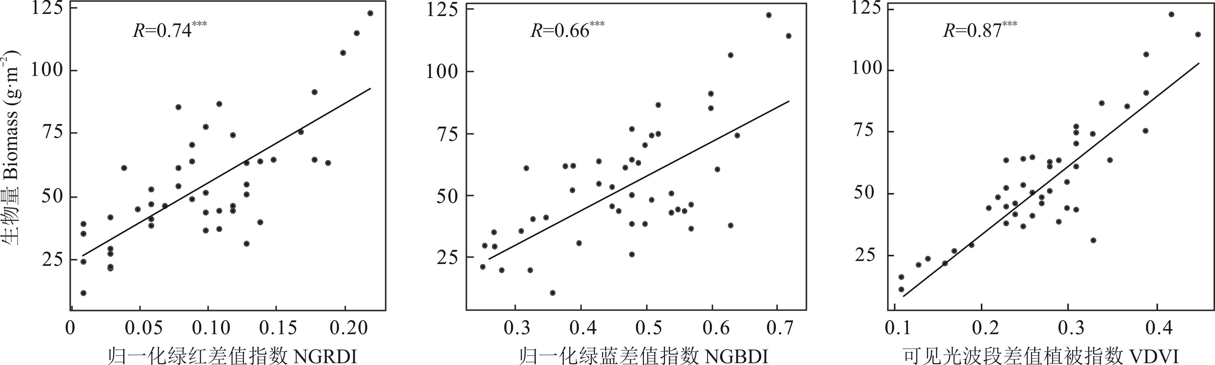
图3 生物量与植被指数相关性关系*: P<0.05; **: P<0.01; ***: P<0.001; 下同The same below.
Fig.3 Correlation between biomass and vegetation index
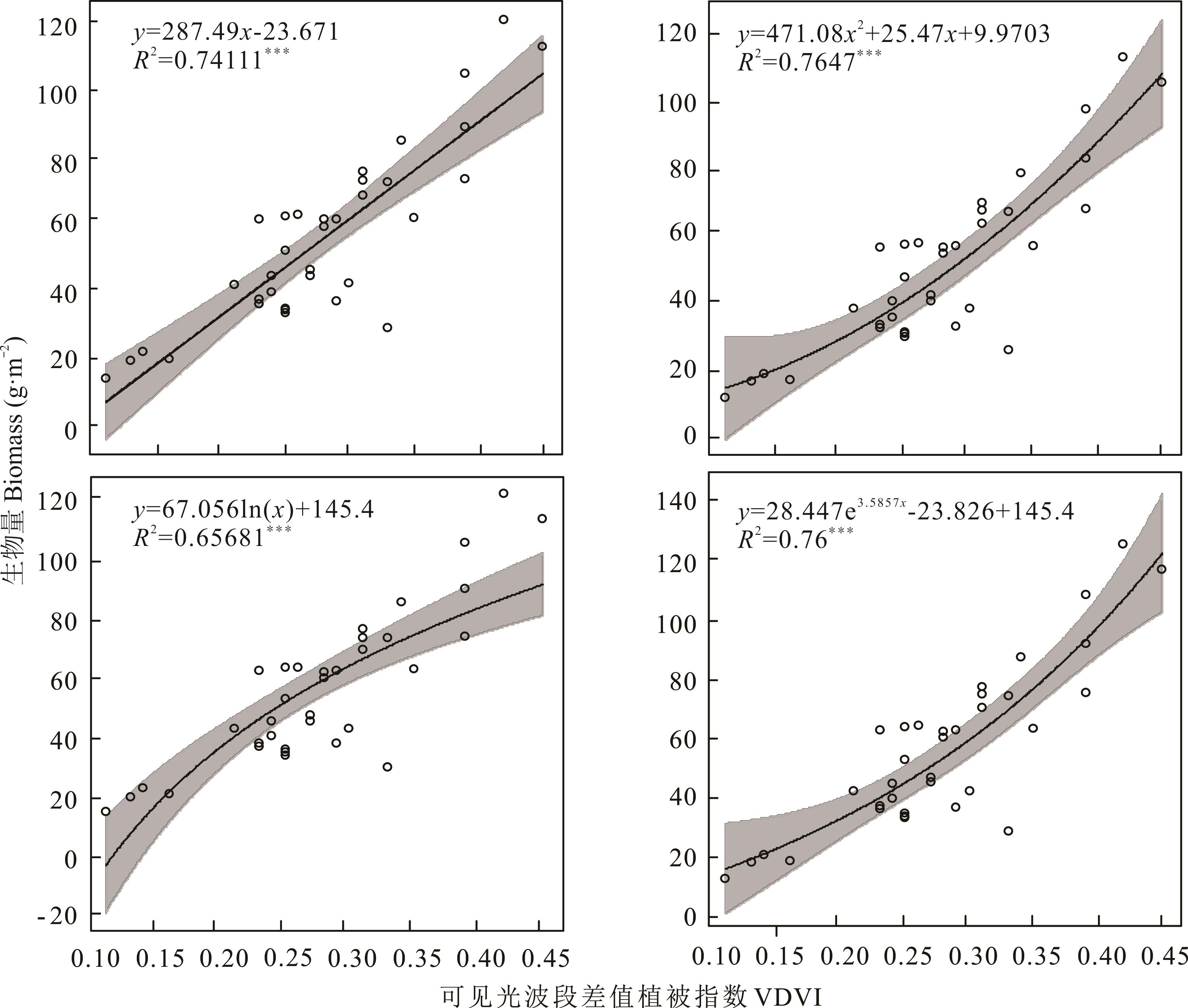
图4 生物量与可见光波段差异植被指数的拟合
Fig.4 Correlation between biomass and VDVI
样方号 Quadrat number | 经度 Longitude | 纬度 Latitude | 实测值 Measuring value | 预测值 Estimating value | 绝对误差 Absolute error | 估产精度 Yield estimation accuracy (%) |
|---|---|---|---|---|---|---|
| 1 | 101.0011 | 34.0189 | 45.24 | 51.1889 | 5.9489 | 86.85 |
| 2 | 102.0014 | 33.1353 | 47.49 | 38.3740 | 9.1160 | 80.80 |
| 3 | 101.0850 | 33.1511 | 60.44 | 63.1368 | 2.6968 | 95.53 |
| 4 | 101.1339 | 33.1186 | 50.27 | 54.0346 | 3.7646 | 92.51 |
| 5 | 102.0672 | 33.1344 | 84.36 | 83.8851 | 0.4749 | 99.43 |
| 6 | 101.0525 | 33.0014 | 44.06 | 40.7485 | 3.3115 | 92.48 |
| 7 | 101.1017 | 33.0011 | 25.91 | 27.9144 | 2.0044 | 92.26 |
| 8 | 101.1186 | 33.0186 | 51.72 | 40.7485 | 10.9715 | 78.78 |
| 9 | 101.0000 | 33.1011 | 40.21 | 48.4375 | 8.2275 | 79.53 |
| 10 | 101.0019 | 33.1172 | 28.44 | 31.8156 | 3.3756 | 88.13 |
| 11 | 101.1167 | 33.0503 | 49.62 | 48.4375 | 1.1825 | 97.61 |
| 12 | 101.1167 | 33.0839 | 53.94 | 60.0085 | 6.0685 | 88.74 |
| 13 | 101.0669 | 33.0006 | 42.76 | 63.1368 | 20.3768 | 52.34 |
表1 预测值与实测值误差及估产精度
Table 1 The absolute error and yield estimation accuracy between simulate data and measuring data
样方号 Quadrat number | 经度 Longitude | 纬度 Latitude | 实测值 Measuring value | 预测值 Estimating value | 绝对误差 Absolute error | 估产精度 Yield estimation accuracy (%) |
|---|---|---|---|---|---|---|
| 1 | 101.0011 | 34.0189 | 45.24 | 51.1889 | 5.9489 | 86.85 |
| 2 | 102.0014 | 33.1353 | 47.49 | 38.3740 | 9.1160 | 80.80 |
| 3 | 101.0850 | 33.1511 | 60.44 | 63.1368 | 2.6968 | 95.53 |
| 4 | 101.1339 | 33.1186 | 50.27 | 54.0346 | 3.7646 | 92.51 |
| 5 | 102.0672 | 33.1344 | 84.36 | 83.8851 | 0.4749 | 99.43 |
| 6 | 101.0525 | 33.0014 | 44.06 | 40.7485 | 3.3115 | 92.48 |
| 7 | 101.1017 | 33.0011 | 25.91 | 27.9144 | 2.0044 | 92.26 |
| 8 | 101.1186 | 33.0186 | 51.72 | 40.7485 | 10.9715 | 78.78 |
| 9 | 101.0000 | 33.1011 | 40.21 | 48.4375 | 8.2275 | 79.53 |
| 10 | 101.0019 | 33.1172 | 28.44 | 31.8156 | 3.3756 | 88.13 |
| 11 | 101.1167 | 33.0503 | 49.62 | 48.4375 | 1.1825 | 97.61 |
| 12 | 101.1167 | 33.0839 | 53.94 | 60.0085 | 6.0685 | 88.74 |
| 13 | 101.0669 | 33.0006 | 42.76 | 63.1368 | 20.3768 | 52.34 |
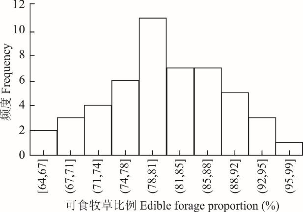
图5 可食牧草比例频度
Fig.5 Frequency of edible forage proportion

图6 影像解译结果与实测值相关性分析I: A)航拍原图Original image; B)二值化影像Binary image; C)轮廓检索影像Contour retrieval image; Ⅱ: 实测个数与解译个数相关性Correlation between the number of measurements and interpretation; Ⅲ: A)航拍原图Original image; B)二值化影像Binary image; C)轮廓检索影像Contour retrieval image; Ⅳ: 实测盖度与解译盖度相关性Correlation between measured coverage and interpretation coverage;图中各点代表不同样地The points in the figure represent different places.
Fig.6 Correlation analysis between image interpretation results and measured values
成分 Components | 初始特征根值 Initial eigenvalue | 方差贡献率 Contribution rate of variance (%) | 累积方差贡献率 Cumulative variance contribution rate (%) |
|---|---|---|---|
| 1 | 1.868 | 46.698 | 46.698 |
| 2 | 0.945 | 23.617 | 70.315 |
| 3 | 0.764 | 19.112 | 89.427 |
| 4 | 0.432 | 10.573 | 100 |
表2 主成分特征根值及方差贡献率
Table 2 The principal component eigenvalue and variance contribution rate
成分 Components | 初始特征根值 Initial eigenvalue | 方差贡献率 Contribution rate of variance (%) | 累积方差贡献率 Cumulative variance contribution rate (%) |
|---|---|---|---|
| 1 | 1.868 | 46.698 | 46.698 |
| 2 | 0.945 | 23.617 | 70.315 |
| 3 | 0.764 | 19.112 | 89.427 |
| 4 | 0.432 | 10.573 | 100 |
指标 Indicator | 载荷数Load number | 系数 Coefficient | ||
|---|---|---|---|---|
第1主成分 The first principal component | 第2主成分 The second principal component | 第1主成分 The first principal component | 第2主成分 The second principal component | |
| 鼠洞个数Pikas’ hole amount | -0.588 | 0.408 | -0.266 | 0.665 |
| 可见光波段植被指数VDVI | 0.796 | 0.380 | 0.873 | -0.121 |
| 解译盖度Interpretation coverage | 0.809 | 0.351 | 0.869 | -0.153 |
| 牧草比例Proportion of edible forage | -0.483 | 0.715 | -0.010 | 0.863 |
表3 各指标载荷数和系数
Table 3 Load number and coefficient of each indicator
指标 Indicator | 载荷数Load number | 系数 Coefficient | ||
|---|---|---|---|---|
第1主成分 The first principal component | 第2主成分 The second principal component | 第1主成分 The first principal component | 第2主成分 The second principal component | |
| 鼠洞个数Pikas’ hole amount | -0.588 | 0.408 | -0.266 | 0.665 |
| 可见光波段植被指数VDVI | 0.796 | 0.380 | 0.873 | -0.121 |
| 解译盖度Interpretation coverage | 0.809 | 0.351 | 0.869 | -0.153 |
| 牧草比例Proportion of edible forage | -0.483 | 0.715 | -0.010 | 0.863 |
指标 Indicator | 贡献率Contribution rate (%) | 权重Weight |
|---|---|---|
| 鼠洞个数Pikas’ hole amount | 4.67 | 0.0485 |
| 可见光波段植被指数 VDVI | 53.91 | 0.5599 |
| 解译盖度Interpretation coverage | 52.57 | 0.5460 |
| 可食牧草比例Proportion of edible forage | 28.32 | 0.2941 |
表4 各指标贡献率和权重
Table 4 Contribution rate and weight of each indicator
指标 Indicator | 贡献率Contribution rate (%) | 权重Weight |
|---|---|---|
| 鼠洞个数Pikas’ hole amount | 4.67 | 0.0485 |
| 可见光波段植被指数 VDVI | 53.91 | 0.5599 |
| 解译盖度Interpretation coverage | 52.57 | 0.5460 |
| 可食牧草比例Proportion of edible forage | 28.32 | 0.2941 |
等级 Level | 鼠洞个数 Pikas’ hole amount | 可见光波段差值植被指数 Visible-band difference vegetation index | 植被盖度 Vegetation coverage (%) | 可食牧草比例 Proportion of edible forage (%) | 草地危害指数 Damage rangeland index |
|---|---|---|---|---|---|
| I | 98.33±52.815 | 0.388±0.018 | 98.117±0.890 | 82.186±1.163 | 1.139±0.014 |
| Ⅱ | 777.42±387.576 | 0.306±0.015 | 97.500±0.681 | 80.645±1.924 | 0.998±0.011 |
| Ⅲ | 993.50±269.462 | 0.266±0.009 | 92.236±1.204 | 80.359±2.180 | 0.864±0.010 |
| Ⅳ | 1374.50±351.268 | 0.224±0.012 | 88.602±1.398 | 80.239±2.637 | 0.725±0.017 |
| V | 874.00±134.447 | 0.127±0.009 | 75.667±4.631 | 76.814±6.744 | 0.322±0.062 |
表5 高原鼠兔危害级别划分标准
Table 5 Demarcation standard of damage grade for plateau pika
等级 Level | 鼠洞个数 Pikas’ hole amount | 可见光波段差值植被指数 Visible-band difference vegetation index | 植被盖度 Vegetation coverage (%) | 可食牧草比例 Proportion of edible forage (%) | 草地危害指数 Damage rangeland index |
|---|---|---|---|---|---|
| I | 98.33±52.815 | 0.388±0.018 | 98.117±0.890 | 82.186±1.163 | 1.139±0.014 |
| Ⅱ | 777.42±387.576 | 0.306±0.015 | 97.500±0.681 | 80.645±1.924 | 0.998±0.011 |
| Ⅲ | 993.50±269.462 | 0.266±0.009 | 92.236±1.204 | 80.359±2.180 | 0.864±0.010 |
| Ⅳ | 1374.50±351.268 | 0.224±0.012 | 88.602±1.398 | 80.239±2.637 | 0.725±0.017 |
| V | 874.00±134.447 | 0.127±0.009 | 75.667±4.631 | 76.814±6.744 | 0.322±0.062 |
等级 Level | 鼠洞个数 Pikas’ hole amount | 可见光波段差值植被指数 Visible-band difference vegetation index | 植被盖度 Vegetation coverage (%) | 可食牧草比例 Proportion of edible forage (%) | 草地危害指数 Damage rangeland index |
|---|---|---|---|---|---|
| I | 68~326 | 0.37~0.45 | 98.1~99.9 | 81.407~84.504 | 1.111~1.187 |
| Ⅱ | 298~971 | 0.29~0.35 | 94.5~98.4 | 80.474~81.879 | 0.952~1.053 |
| Ⅲ | 726~1108 | 0.25~0.31 | 89.0~95.0 | 80.295~80.596 | 0.801~0.910 |
| Ⅳ | 1273~1864 | 0.19~0.26 | 83.0~89.1 | 76.825~80.343 | 0.550~0.790 |
| V | 353~1051 | 0.11~0.18 | 68.0~81.0 | 63.636~78.219 | 0.202~0.407 |
表6 危害级别中各指标的极值
Table 6 Ranges of damage indexes in all damage levels
等级 Level | 鼠洞个数 Pikas’ hole amount | 可见光波段差值植被指数 Visible-band difference vegetation index | 植被盖度 Vegetation coverage (%) | 可食牧草比例 Proportion of edible forage (%) | 草地危害指数 Damage rangeland index |
|---|---|---|---|---|---|
| I | 68~326 | 0.37~0.45 | 98.1~99.9 | 81.407~84.504 | 1.111~1.187 |
| Ⅱ | 298~971 | 0.29~0.35 | 94.5~98.4 | 80.474~81.879 | 0.952~1.053 |
| Ⅲ | 726~1108 | 0.25~0.31 | 89.0~95.0 | 80.295~80.596 | 0.801~0.910 |
| Ⅳ | 1273~1864 | 0.19~0.26 | 83.0~89.1 | 76.825~80.343 | 0.550~0.790 |
| V | 353~1051 | 0.11~0.18 | 68.0~81.0 | 63.636~78.219 | 0.202~0.407 |
| 1 | Gao Y, Lin H L. The prospects for rangeland ecosystem services evaluation. Acta Prataculturae Sinica, 2014, 3(3): 290-301. |
| 高雅, 林慧龙. 草地生态系统服务价值估算前瞻. 草业学报, 2014, 3(3): 290-301. | |
| 2 | Wu X Y, Ping C. Study on grassland ecosystem and its ecological restoration in Tibetan Plateau. Environmental Protection Science, 2021,47(1): 109-114. |
| 吴晓燕, 平措. 西藏高原草地生态系统及其生态修复研究. 环境保护科学, 2021, 47(1): 109-114. | |
| 3 | Lin L, Li Y, Xu X, et al. Predicting parameters of degradation succession processes of Tibetan Kobresia grasslands. Solid Earth, 2015, 6(4):1237-1246. |
| 4 | Guo Z G, Wang Q, Chen H. Issues and suggestions for rodent control of the natural grassland in China. Pratacultural Science, 2014, 31(1): 168-172. |
| 郭正刚, 王倩, 陈鹤. 我国天然草地鼠害防控中的问题与对策. 草业科学, 2014, 31(1): 168-172. | |
| 5 | Wang S, Duan J C, Xu G P, et al. Effects of warming and grazing on soil N availability, species composition, and ANPP in an alpine meadow. Ecology, 2012,93(11): 2365-2376. |
| 6 | Zhong W Q, Fan N C. Causes of rodent infestation in grassland of China and countermeasures for ecological management. Bulletin of Biology, 2002(7): 1-4. |
| 钟文勤, 樊乃昌. 我国草地鼠害的发生原因及其生态治理对策. 生物学通报, 2002(7): 1-4. | |
| 7 | Harris R B. Rangeland degradation on the Qinghai-Tibetan Plateau: A review of the evidence of its magnitude and causes. Journal of Arid Environments, 2010, 74(1): 1-12. |
| 8 | Gong L H, Zheng Q Y, Xiao B X, et al. Advance in the research of grassland rodent calamity control in China. Sichuan Cao Yuan, 2005(5): 48-60. |
| 工丽焕, 郑群英, 肖冰雪, 等. 我国草地鼠害防治研究进展. 四川草原, 2005(5): 48-60. | |
| 9 | Yan H Y, Zhang Y, Zhao J Z, et al. Effects of plateau pika (Ochotona curzoniae) on plant community biomass in alpine meadow. Acta Theriologica Sinica, 2013, 33(4): 333-343. |
| 严红宇, 张毓, 赵建中, 等. 高原鼠兔对高寒草甸植物群落生物量的影响. 兽类学报, 2013, 33(4): 333-343. | |
| 10 | Zhang Z B. Grassland rodent damage and management strategy. Science and Society, 2003(5): 343-347. |
| 张知彬. 我国草原鼠害的严重性及防治对策. 科技与社会, 2003(5): 343-347. | |
| 11 | Liu W, Yan H Y, Wang X, et al. Effects of plateau pikas on restoring succession of degraded grassland and plant community structure. Acta Theriologica Sinica, 2014, 34(1):54-61. |
| 刘伟, 严红宇, 王溪, 等. 高原鼠兔对退化草地植物群落结构及恢复演替的影响. 兽类学报, 2014, 34(1): 54-61. | |
| 12 | Sun F D, Long R J, Guo Z G, et al. Effects of rodents activities on plant community and soil environment in alpine meadow. Pratacultural Science, 2011, 28(1):146-151. |
| 孙飞达, 龙瑞军, 郭正刚, 等. 鼠类活动对高寒草甸植物群落及土壤环境的影响. 草业科学, 2011, 28(1): 146-151. | |
| 13 | Davidson A D, Detling J K, Brown J H. Ecological roles and conservation challenges of social, burrowing, herbivorous mammals in the world’s grasslands. Frontiers in Ecology and the Environment, 2012, 10(9): 477-486. |
| 14 | Reichman O J, Seabloom E W. The role of pocket gophers as subterranean ecosystem engineers. Trends in Ecology and Evolution, 2002, 17(1): 44-49. |
| 15 | Chen J, Wang Z Q, Wang Y, et al. Methods for investigating the density of the plateau pika in northern Tibetan Plateau. Plant Protection, 2008(4): 114-117. |
| 陈剑, 王忠全, 王勇, 等. 藏北草原高原鼠兔密度调查方法探讨. 植物保护, 2008(4): 114-117. | |
| 16 | Zhang J B, Gu J, Li J Z, et al. Study on the efficacy of new rodenticide against rodent in field. Chinese Journal of Vector Biology and Control, 2005(4): 78-81. |
| 章进宝, 顾健, 李家振, 等. 新型灭鼠药现场灭鼠效果试验研究. 中国媒介生物学及控制杂志, 2005(4): 78-81. | |
| 17 | Han T H, Hua L M, Xu G C. Rodent damage assessment on the plateau pika. Acta Prataculturae Sinica, 2008, 17(5):130-137. |
| 韩天虎, 花立民, 许国成. 高原鼠兔危害级别划分.草业学报, 2008, 17(5): 130-137. | |
| 18 | Xuan J W, Zheng J H, Ni Y F, et al. Remote sensing monitoring of grassland rodents based on dynamic delta wing platform. China Plant Protection, 2015, 35(2): 52-55. |
| 轩俊伟, 郑江华, 倪亦非, 等. 基于动力三角翼平台的草原鼠害遥感监测研究. 中国植保导刊, 2015, 35(2):52-55. | |
| 19 | Hua R, Zhou R, Bao D E H, et al. Prediction of geographical distribution for plateau pikas and its potential response to climate change in Maqu county. Grassland and Turf, 2020, 40(3):1-8. |
| 花蕊, 周睿, 包达尔罕, 等. 玛曲县高原鼠兔地理分布预测及其对气候变化的潜在响应. 草原与草坪, 2020, 40(3): 1-8. | |
| 20 | Maqu County Annals Compilation Committee. Maqu County Annals. Lanzhou: Gansu Nationalities Publishing House, 2005. |
| 玛曲县志编纂委员会. 玛曲县志. 兰州: 甘肃民族出版社, 2005. | |
| 21 | Li X P. Summary of Maqu County. Lanzhou: Gansu Nationalities Publishing House, 2018: 400. |
| 李晓鹏. 玛曲县综述. 兰州: 甘肃民族出版社, 2018: 400. | |
| 22 | Chen L, Michalk D, Ling H B, et al. A new method for monitoring the yield and vegetation community composition of natural grassland. Inner Mongolia Prataculture, 2003(1): 46-47. |
| 陈良, Michalk D, 凌红波, 等. 浅谈监测天然草场产量和植被群落组成的新方法. 内蒙古草业, 2003(1): 46-47. | |
| 23 | Chen S. Forage plant resources of grassland in China. Shenyang: Liaoning Nationalities Publishing House, 1994. |
| 陈山. 中国草地饲用植物资源.沈阳: 辽宁民族出版社, 1994. | |
| 24 | Hua L M. Efficient production technology of grassland ecological industry. Beijing: China Science and Technology Press, 2013:1-27. |
| 花立民. 草原生态业高效生产技术. 北京: 中国科学技术出版社, 2013: 1-27. | |
| 25 | Louhaichi M, Borman M M, Johnson D E. Spatially located platform and aerial photography for documentation of grazing impacts on wheat. Geocarto International, 2001(16): 65-70. |
| 26 | Wang X Q, Wang M M, Wang S Q, et al. Extraction of vegetation information from visible unmanned aerial vehicle images. Transactions of the Chinese Society of Agricultural Engineering, 2015, 31(5): 152-159. |
| 汪小钦, 王苗苗, 王绍强, 等. 基于可见光波段无人机遥感的植被信息提取. 农业工程学报, 2015, 31(5): 152-159. | |
| 27 | Zhang B G, Liang H C. Research progress on community diversity of natural grassland. Modern Agricultural Science and Technology, 2011(5): 207-208, 213. |
| 张保刚, 梁慧春. 天然草地群落多样性研究进展. 现代农业科技, 2011(5): 207-208, 213. | |
| 28 | Meyer G E, Camargo N J. Verification of color vegetation indices for automated crop image application. Computers and Electronics in Agriculture, 2008(63): 282-293. |
| 29 | Tucker C. Red and photographic infrared linear combinations for monitoring vegetation. Remote Sensing of Environment, 1979(8): 127-150. |
| 30 | Jiang H, Jiang X Q, Wu B, et al. A topography-adjusted vegetation index (TAVI) and its application in vegetation fraction monitoring. Journal of Fuzhou University (Natural Science Edition), 2010, 38(4): 527-532. |
| 江洪, 江小钦, 吴波, 等. 地形调节植被指数构建及在植被覆盖度遥感监测中的应用. 福州大学学报 (自然科学版), 2010, 38(4): 527-532. | |
| 31 | Han X H, Zhang Y H, Sun F J, et al. Method for determining index weight based on principal component analysis. Journal of Sichuan Ordnance Industry, 2012, 33(10): 124-126. |
| 韩小孩, 张耀辉, 孙福军, 等. 基于主成分分析的指标权重确定方法. 四川兵工学报, 2012, 33(10): 124-126. | |
| 32 | Feng S S. Dynamic monitoring of grassland degradation based on Landsat image: A case study in Bashang area. Shijiazhuang: Hebei Normal University, 2016. |
| 冯双双. 基于Landsat影像的草地退化动态监测-以坝上草原为例. 石家庄: 河北师范大学, 2016. | |
| 33 | Zhong W Q. The role of rodents in grassland ecosystem and scientific management. Bulletin of Biology, 2008(1): 1-3. |
| 钟文勤. 啮齿动物在草原生态系统中的作用与科学管理. 生物学通报, 2008(1): 1-3. | |
| 34 | Fan N C, Zhang D C. Foraging behavior of Ochotona curzoniae and Ochotona daurica and their adaptation to habitat. Acta Theriologica Sinica, 1996, 16(1): 48-53. |
| 樊乃昌, 张道川. 高原鼠兔与达乌尔鼠兔的摄食行为及对栖息地适应性的研究. 兽类学报, 1996, 16(1): 48-53. |
| [1] | 徐海鹏, 于成, 舒朝成, 金少红, 庞晓攀, 郭正刚. 高原鼠兔干扰对高寒草甸植物群落多样性和稳定性的影响[J]. 草业学报, 2019, 28(5): 90-99. |
| [2] | 张灵菲, 卫万荣, 石高宇, 张卫国. 高寒草甸植物群落结构对高原鼠兔种群密度的影响[J]. 草业学报, 2019, 28(3): 93-100. |
| [3] | 杨帆, 邵全琴, 郭兴健, 李愈哲, 王东亮, 张雅娴, 汪阳春, 刘纪远, 樊江文. 玛多县大型野生食草动物种群数量对草畜平衡的影响研究[J]. 草业学报, 2018, 27(7): 1-13. |
| [4] | 张卫红, 苗彦军, 赵玉红, 王向涛, 徐雅梅, 魏学红, 孙磊. 高原鼠兔对西藏邦杰塘高寒草甸的影响[J]. 草业学报, 2018, 27(1): 115-115. |
| [5] | 金少红, 刘彤, 庞晓攀, 于成, 郭正刚. 高原鼠兔干扰对青海湖流域高山嵩草草甸植物多样性及地上生物量的影响[J]. 草业学报, 2017, 26(5): 29-39. |
| [6] | 张永超, 袁晓波, 牛得草, 吴淑娟, 张典业, 宗文杰, 傅华. 玛曲高寒草甸高原鼠兔种群数量对植被调控措施的响应[J]. 草业学报, 2016, 25(2): 87-94. |
| [7] | 庞晓攀, 王倩, 贾婷婷, 李倩倩, 郭正刚. 高原鼠兔有效洞口数密度对高山嵩草草甸植物种间联结性的影响[J]. 草业学报, 2015, 24(5): 224-230. |
| [8] | 卫万荣,张灵菲,杨国荣,徐吉伟,范旭东,张卫国. 高原鼠兔洞系特征及功能研究[J]. 草业学报, 2013, 22(6): 198-204. |
| [9] | 王兴堂,花立民,苏军虎,曹慧,祁小梅,王俊梅,刘荣堂*. 高原鼠兔的精确性可持续控制技术研究——几种杀鼠剂的对比试验[J]. 草业学报, 2010, 19(1): 191-200. |
| [10] | 王兴堂,花立民,苏军虎,曹慧,祁晓梅,刘荣堂*. 高原鼠兔的经济损害水平及防治指标研究[J]. 草业学报, 2009, 18(6): 198-204. |
| 阅读次数 | ||||||
|
全文 |
|
|||||
|
摘要 |
|
|||||