

ISSN 1004-5759 CN 62-1105/S
草业学报 ›› 2023, Vol. 32 ›› Issue (5): 71-82.DOI: 10.11686/cyxb2022234
花蕊( ), 包达尔罕, 董瑞, 唐庄生, 楚彬, 郝媛媛, 花立民()
收稿日期:2022-05-25
修回日期:2022-07-02
出版日期:2023-05-20
发布日期:2023-03-20
通讯作者:
花立民
作者简介:. E-mail: hualm@gsau.edu.cn基金资助:
Rui HUA(), Daerhan BAO, Rui DONG, Zhuang-sheng TANG, Bin CHU, Yuan-yuan HAO, Li-min HUA()
Received:2022-05-25
Revised:2022-07-02
Online:2023-05-20
Published:2023-03-20
Contact:
Li-min HUA
摘要:
草原鼠害是目前我国为害面积最大、影响最为广泛的草原生物灾害。掌握草原鼠害发生面积是评估其为害程度和制定防治策略的重中之重。当前草原鼠害发生面积调查采用填图法或勾绘法,这两种方法均存在效率低、准确性差的问题,难以满足草原鼠害精准管理的要求。本研究以生态学和统计学理论为基础,采用无人机低空遥感技术,以青藏高原优势害鼠高原鼠兔为测试对象,以甘肃玛曲县4个乡镇为测试区域展开天然草地鼠害发生面积调查。1)首先确定被调查鼠种的一级调查区,即害鼠适生区;2)在一级调查区依据不同栖息地类型作为二级调查样地并划分为网格;3)在二级样地中随机抽样一定数量的样方,作为三级样方用于无人机调查;4)依据多个样方平均鼠害发生面积统计出二级样地的草原鼠害发生面积,汇总各二级样地发生面积获得调查区的鼠害发生总面积。结果显示,测试区域草原总面积4.6×10⁵ hm2,其中高原鼠兔适生区面积2.5×10⁵ hm2,经抽样调查得到研究区高原鼠兔为害发生面积为1.05×10⁴ hm2。本测试区域共有50个1 hm2样地,以调查1个样地为例,1人需 20 min左右完成内外业工作。相比填图法或勾绘法,本方法高效便捷、结果精度高,可为大尺度草原鼠害发生面积调查提供技术支持。
花蕊, 包达尔罕, 董瑞, 唐庄生, 楚彬, 郝媛媛, 花立民. 基于无人机遥感的天然草原鼠害发生面积调查方法研究[J]. 草业学报, 2023, 32(5): 71-82.
Rui HUA, Daerhan BAO, Rui DONG, Zhuang-sheng TANG, Bin CHU, Yuan-yuan HAO, Li-min HUA. Monitoring of rodent damage areas in grassland using unmanned aerial vehicle remote sensing technology[J]. Acta Prataculturae Sinica, 2023, 32(5): 71-82.

图1 测试区域高原鼠兔分布调查点
Fig.1 Distribution points of plateau pikas in the test area

图2 特征曲线
Fig.2 Characteristic curve

图3 无人机影像解译结果A1、B1为无人机航拍图,图中红色部分为软件自动识别的秃斑块 A2及鼠洞 B2。A1, B1 for UAV aerial photographs, the red part of the photograph is bare land A2 and pika holes B2 automatically identified by software.
Fig.3 UAV image interpretation results

图4 实测值与解译值相关性A为植被实测盖度与解译盖度相关性,B为实测鼠洞数量与解译鼠洞数量相关性;样地大小为100 m×100 m。A is the correlation between the measured coverage of vegetation and the coverage of interpretation; B is the correlation between the number of measured holes and the number of interpreted holes; The sample area is 100 m×100 m.
Fig.4 Correlation between measured values and interpretation values

图5 高原鼠兔潜在分布区
Fig.5 Potential distribution area of plateau pika
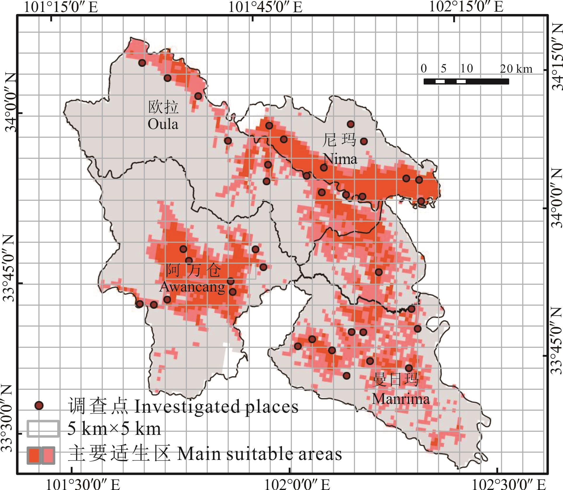
图6 测试区网格化及抽样点选择
Fig.6 Gridding and sampling point selection in the test area
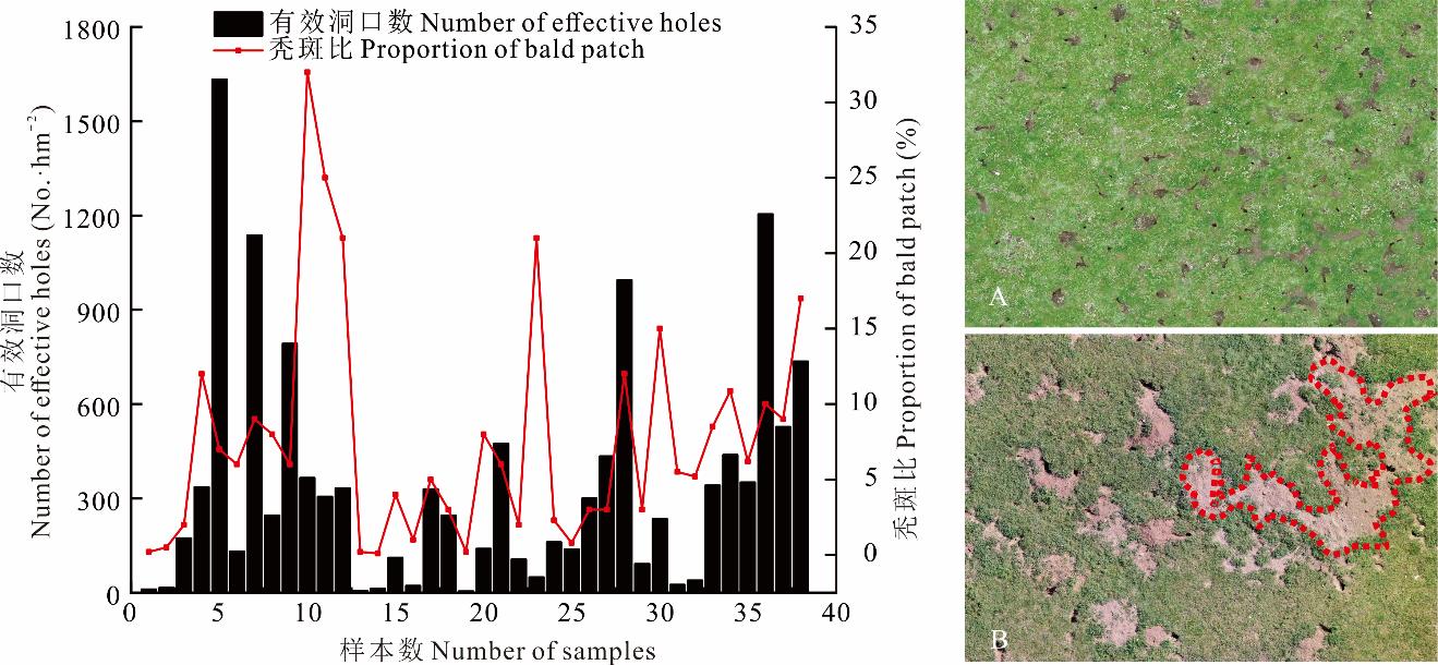
图7 秃斑比与有效洞口数汇总左图为调查区秃斑比与有效洞口数汇总统计,右图A:高鼠洞密度低秃斑比,右图B:低鼠洞密度高秃斑比。The left graph shows the summary statistics of bald patch proportion and effective hole numbers in the survey area, the right graph A: High effective holes density and low proportion of bald patch, the right graph B: Low effective holes density and high proportion of bald patch.
Fig.7 Summary of bald patch proportion and effective hole numbers
区域 Area | 抽样率 Sample rate (%) | 鼠害发生率 Incidence of rodent pest damage (%) | 样地草原面积 Grassland area of the sample plot (hm2) | 样地鼠害发生面积 Area of rodent damage in sample plots (hm2) | 平均总洞口数 Average total number of holes (No.·hm-2) | 平均有效洞口数 Average number of effective holes (No.·hm-2) |
|---|---|---|---|---|---|---|
| 尼玛Nima | 27.5 | 5.6 | 62000 | 3454.28 | 1168.4 | 418.29 |
| 欧拉Oula | 21.4 | 5.1 | 64800 | 3324.24 | 496.3 | 177.68 |
| 阿万仓Awancang | 20.5 | 2.2 | 75000 | 1612.50 | 820.8 | 293.85 |
| 曼日玛Manrima | 18.4 | 4.1 | 52600 | 2147.83 | 1319.0 | 472.20 |
| 合计Total | 87.8 | 1.7 | 254400 | 10538.85 | 3804.5 | 1362.02 |
表1 调查区鼠害发生面积
Table 1 Area of hazard in survey area
区域 Area | 抽样率 Sample rate (%) | 鼠害发生率 Incidence of rodent pest damage (%) | 样地草原面积 Grassland area of the sample plot (hm2) | 样地鼠害发生面积 Area of rodent damage in sample plots (hm2) | 平均总洞口数 Average total number of holes (No.·hm-2) | 平均有效洞口数 Average number of effective holes (No.·hm-2) |
|---|---|---|---|---|---|---|
| 尼玛Nima | 27.5 | 5.6 | 62000 | 3454.28 | 1168.4 | 418.29 |
| 欧拉Oula | 21.4 | 5.1 | 64800 | 3324.24 | 496.3 | 177.68 |
| 阿万仓Awancang | 20.5 | 2.2 | 75000 | 1612.50 | 820.8 | 293.85 |
| 曼日玛Manrima | 18.4 | 4.1 | 52600 | 2147.83 | 1319.0 | 472.20 |
| 合计Total | 87.8 | 1.7 | 254400 | 10538.85 | 3804.5 | 1362.02 |
| 1 | Bengtsson J, Bullock J M, Egoh B, et al. Grasslands-more important for ecosystem services than you might think. Ecosphere, 2019, 10(2): e02582. |
| 2 | The 3rd National Land Survey Leading Group of the State Council, Ministry of Natural Resources, National Bureau of Statistics. A bulletin on the main data results of the third national land survey. Beijing: People’s Daily, 2021. |
| 国务院第三次全国国土调查领导小组办公室, 自然资源部, 国家统计局. 第三次全国国土调查主要数据公报.北京: 人民日报, 2021. | |
| 3 | Qi Y C, Dong Y S, Geng Y B, et al. The progress in the carbon cycle researches in grassland ecosystem in China. Progress in Geography, 2003, 22(4): 342-352. |
| 齐玉春, 董云社, 耿元波, 等. 我国草地生态系统碳循环研究进展. 地理科学进展, 2003, 22(4): 342-352. | |
| 4 | Wei X H, Yang F Y, Sun L. Harm and control of plateau pika on alpine grassland in Tibet. Journal of Sichuan Grassland, 2006(5): 41-42, 45. |
| 魏学红, 杨富裕, 孙磊. 高原鼠兔对西藏高寒草地的危害及防治. 四川草原, 2006(5): 41-42, 45. | |
| 5 | Hua L M, Chai S Q. Rodents pest control on grassland in China: current state, problems and prospects. Journal of Plant Protection, 2022, 49(1): 415-423. |
| 花立民, 柴守权. 中国草原鼠害防治现状、问题及对策. 植物保护学报, 2022, 49(1): 415-423. | |
| 6 | Hua L M, Cai X C. Recent advances in ecological studies for plateau zokor (Eospalax baileyi): a review. Journal of Gansu Agricultural University, 2021, 56(2): 1-10, 17. |
| 花立民, 蔡新成. 高原鼢鼠(Eospalax baileyi)的生态学研究进展. 甘肃农业大学学报, 2021, 56(2): 1-10, 17. | |
| 7 | Jiang X L. Relationship of population quantities of plateau pika with vegetation homogeneity. Acta Prataculturae Sinica, 1998, 7(1): 61-65. |
| 江小蕾. 植被均匀度与高原鼠兔种群数量相关性研究. 草业学报, 1998, 7(1): 61-65. | |
| 8 | Wang D L, Li X C, Pan D F, et al. The ecological significance and controlling of rodent outbreaks in the Qinghai-Tibetan grasslands. Journal of Southwest Minzu University, 2016, 42(3): 237-245. |
| 王德利, 李心诚, 潘多峰, 等. 青藏高原草地鼠害的生态释义及控制. 西南民族大学学报, 2016, 42(3): 237-245. | |
| 9 | Tang Z M. Study on Gannan prairie rat damage regionalization and control technique and prevention and control strategic for main harmful rodents. Lanzhou: Lanzhou University, 2010. |
| 唐忠民. 甘南草原鼠害区划及主要害鼠防治技术与防控战略研究. 兰州: 兰州大学, 2010. | |
| 10 | Fang Y C, Shi Q M. Harm and prevention of plateau pika in Gansu grassland. Gansu Agriculture, 1998(6): 41-42. |
| 方毅才, 史青茂. 甘肃草地高原鼠兔危害与防治探讨. 甘肃农业, 1998(6): 41-42. | |
| 11 | Xiong R D, Cheng W X, Xiong Y D, et al. Estimation model of rodent damage degree in Zoige alpine grassland based on UAV. China Agricultural Informatics, 2020, 32(6): 32-45. |
| 熊瑞东, 程武学, 熊钰丹, 等. 基于无人机的若尔盖高寒草地鼠害程度估算模型研究. 中国农业信息, 2020, 32(6): 32-45. | |
| 12 | Hua R. Study on the technology for classifying damage level of plateau pika (Ochotona curzoniae) to alpine rangeland based on UAV remote sensing. Lanzhou: Gansu Agricultural University, 2020. |
| 花蕊. 基于旋翼无人机低空遥感的高原鼠兔(Ochotona curzoniae)危害等级划分技术研究. 兰州: 甘肃农业大学, 2020. | |
| 13 | Huang J J, Lan X Q. The application of grey disaster in long-term prediction of rodent damage area in farmland. Guangxi Plant Protection, 2003(3): 8-10. |
| 黄军军, 兰雪琼. 灰色灾变在农田鼠害发生面积长期预报中的应用. 广西植保, 2003(3): 8-10. | |
| 14 | Liu R T, Wu X D. Grassland conservation science. Beijing: China Agriculture Press, 2011. |
| 刘荣堂, 武晓东. 草地保护学. 北京: 中国农业出版社, 2011. | |
| 15 | Liu L, Hua L M, Yang S W, et al. The habitat selection of plateau zokor (Myospalax baileyi) under grazing disturbance. Chinese Journal of Zoology, 2015, 50(5): 725-734. |
| 刘丽, 花立民, 杨思维, 等. 放牧干扰下高原鼢鼠栖息地选择因素. 动物学杂志, 2015, 50(5): 725-734. | |
| 16 | Ji S N, Cui S P, Deng H Q, et al. Sampling survey strategy in biodiversity conservation priority areas: the case of Wuling Mountains. Acta Ecologica Sinica, 2021, 41(24): 9604-9612. |
| 吉晟男, 崔绍朋, 邓怀庆, 等. 生物多样性保护优先区抽样调查策略研究——以武陵山地区为例. 生态学报, 2021, 41(24): 9604-9612. | |
| 17 | Hu J B, Zhang J. Unmanned aerial vehicle remote sensing in ecology: Advances and prospects. Acta Ecologica Sinica, 2018, 38(1): 20-30. |
| 胡健波, 张健. 无人机遥感在生态学中的应用进展. 生态学报, 2018, 38(1): 20-30. | |
| 18 | Guo Q H, Wu F F, Hu T Y, et al. Perspectives and prospects of unmanned aerial vehicle in remote sensing monitoring of biodiversity. Biodiversity Science, 2016, 24(11): 1267-1278. |
| 郭庆华, 吴芳芳, 胡天宇, 等. 无人机在生物多样性遥感监测中的应用现状与展望. 生物多样性, 2016, 24(11): 1267-1278. | |
| 19 | Ma T, Zheng J H, Wen A M, et al. Group coverage of burrow entrances and distribution characteristics of desert forest-dwelling Rhombomys opimus based on unmanned aerial vehicle (UAV) low-altitude remote sensing: A case study at the southern margin of the Gurbantunggut Desert in Xinjiang. Acta Ecologica Sinica, 2018, 38(3): 953-963. |
| 马涛, 郑江华, 温阿敏, 等. 基于UAV低空遥感的荒漠林大沙鼠洞群覆盖率及分布特征研究——以新疆古尔班通古特沙漠南缘局部为例. 生态学报, 2018, 38(3): 953-963. | |
| 20 | Zhou S, Han L L, Yang S W, et al. A study of rodent monitoring in Ruoergai grassland based on convolutional neural network. Journal of Grassland and Forage Science, 2021(2): 15-25. |
| 周俗, 韩立亮, 杨思维, 等. 基于卷积神经网络的若尔盖草原鼠害监测应用研究. 草学, 2021(2): 15-25. | |
| 21 | Office of the State Forestry and Grassland Administration. Main grassland pest control indicators. Beijing: National Forestry and Grassland Administration, 2021. |
| 国家林业和草原局办公室. 主要草原有害生物防治指标. 北京: 国家林业和草原局, 2021. | |
| 22 | Yang C Y, Li Z, Gou W D. Study on climate characteristics and temperature variation trend of Maqu County. Journal of Agricultural Catastrophology, 2020, 10(6): 35-36. |
| 杨春芽, 李瑱, 勾卫东. 玛曲县气候特点及气温变化趋势研究. 农业灾害研究, 2020, 10(6): 35-36. | |
| 23 | Yuan H B. Grassland sandification dynamic monitoring and landscape pattern analysis of Maqu County in source region of Yellow River. Lanzhou: Gansu Agricultural University, 2006. |
| 袁宏波. 黄河源区玛曲县草地沙化动态监测及区域景观结构分析研究. 兰州: 甘肃农业大学, 2006. | |
| 24 | Feng Z J, Zheng C L. Studies on the pikas (genus: Ochotona) of China-taxonomic notes and distribution. Acta Theriologica Sinica, 1985, 5(4): 269-289. |
| 冯祚建, 郑昌琳. 中国鼠兔属(Ochotona)的研究——分类与分布. 兽类学报, 1985, 5(4): 269-289. | |
| 25 | Booth T H, Nix H A, Busby J R, et al. Bioclim: the first species distribution modelling package, its early applications and relevance to most current MaxEnt studies. Diversity & Distributions, 2013(1): 1-9. |
| 26 | Phillips S J, Anderson R P, Schapire R E. Maximum entropy modeling of species geographic distributions. Ecological Modelling, 2006(3): 231-259. |
| 27 | Chang M, Zhou Y Y, Zhang W G. The relationship between plateau pika habitat selection and snowfall. Pratacultural Science, 2021, 38(9): 1831-1840. |
| 常明, 周雨阳, 张卫国. 高原鼠兔的栖息地选择与降雪的关系. 草业科学, 2021, 38(9): 1831-1840. | |
| 28 | Liu W, Zhang Y, Wang X, et al. Food selection by plateau pikas in different habitats during plant growing season. Acta Theriologica Sinica, 2008, 28(4): 358-366. |
| 刘伟, 张毓, 王溪, 等. 植物生长季节不同栖息地高原鼠兔的食物选择. 兽类学报, 2008, 28(4): 358-366. | |
| 29 | Guo X L, Yi S H, Qin Y, et al. Habitat environment affects the distribution of plateau pikas: A study based on an unmanned aerial vehicle. Pratacultural Science, 2017, 34(6): 6-13. |
| 郭新磊, 宜树华, 秦彧, 等. 基于无人机的青藏高原鼠兔潜在栖息地环境初步研究. 草业科学, 2017, 34(6): 6-13. | |
| 30 | Shcheglovitova M, Anderson R P. Estimating optimal complexity for ecological niche models: A jackknife approach for species with small sample sizes. Ecological Modelling, 2013(269): 9-17. |
| 31 | Che L, Cao B, Bai C K, et al. Predictive distribution and habitat suitability assessment of Notholirion bulbuliferum based on MaxEnt and ArcGIS. Chinese Journal of Ecology, 2014, 33(6): 1623-1628. |
| 车乐, 曹博, 白成科, 等. 基于MaxEnt和ArcGIS对太白米的潜在分布预测及适宜性评价. 生态学杂志, 2014, 33(6): 1623-1628. | |
| 32 | Chen L, Michalk D, Ling H B, et al. A new method for monitoring natural grassland yield and vegetation community composition. Inner Mongolia Prataculture, 2003, 15(1): 46-47. |
| 陈良, David Michalk, 凌红波, 等. 浅谈监测天然草场产量和植被群落组成的新方法. 内蒙古草业, 2003, 15(1): 46-47. | |
| 33 | Lian H H, Hou X M, Yi S H. Research of using the UAV to carry out field investigation and monitoring of grassland rodents. Qinghai Prataculture, 2021, 30(4): 38-43. |
| 连欢欢, 侯秀敏, 宜树华. 利用无人机开展草原鼠害调查监测的研究. 青海草业, 2021, 30(4): 38-43. | |
| 34 | Green R E, Balmford A, Crane P R, et al. A framework for improved monitoring of biodiversity: Responses to the World Summit on Sustainable Development. Conservation Biology, 2010, 19(1): 56-65. |
| [1] | 花蕊, 周睿, 包达尔罕, 董克池, 唐庄生, 花立民. 基于旋翼无人机低空遥感的高原鼠兔危害等级划分技术研究[J]. 草业学报, 2022, 31(4): 165-176. |
| [2] | 张伟, 宜树华, 秦彧, 上官冬辉, 秦炎. 基于无人机的高寒草甸地表温度监测及影响因素研究[J]. 草业学报, 2021, 30(3): 15-27. |
| [3] | 杨帆, 邵全琴, 郭兴健, 李愈哲, 王东亮, 张雅娴, 汪阳春, 刘纪远, 樊江文. 玛多县大型野生食草动物种群数量对草畜平衡的影响研究[J]. 草业学报, 2018, 27(7): 1-13. |
| [4] | 葛静, 孟宝平, 杨淑霞, 高金龙, 冯琦胜, 梁天刚, 黄晓东, 高新华, 李文龙, 张仁平, 王云龙. 基于UAV技术和MODIS遥感数据的高寒草地盖度动态变化监测研究—以黄河源东部地区为例[J]. 草业学报, 2017, 26(3): 1-12. |
| [5] | 王兴堂,花立民,苏军虎,曹慧,祁小梅,王俊梅,刘荣堂*. 高原鼠兔的精确性可持续控制技术研究——几种杀鼠剂的对比试验[J]. 草业学报, 2010, 19(1): 191-200. |
| [6] | 王兴堂,花立民,苏军虎,曹慧,祁晓梅,刘荣堂*. 高原鼠兔的经济损害水平及防治指标研究[J]. 草业学报, 2009, 18(6): 198-204. |
| 阅读次数 | ||||||
|
全文 |
|
|||||
|
摘要 |
|
|||||