
ISSN 1004-5759 CN 62-1105/S
Acta Prataculturae Sinica ›› 2024, Vol. 33 ›› Issue (7): 1-14.DOI: 10.11686/cyxb2023319
Jie SHE1( ), Ai-hong SHEN2, Yun SHI1(), Na ZHAO1, Feng-hong ZHANG3, Hong-yuan HE3, Tao WU4, Hong-xia LI1, Yi-ting MA1, Xiao-wen ZHU1
Received:2023-09-04
Revised:2023-10-25
Online:2024-07-20
Published:2024-04-08
Contact:
Yun SHI
Jie SHE, Ai-hong SHEN, Yun SHI, Na ZHAO, Feng-hong ZHANG, Hong-yuan HE, Tao WU, Hong-xia LI, Yi-ting MA, Xiao-wen ZHU. Vegetation classification of UAV remote sensing images in desert steppe based on object-oriented technology[J]. Acta Prataculturae Sinica, 2024, 33(7): 1-14.

Fig.1 Overview of the study area
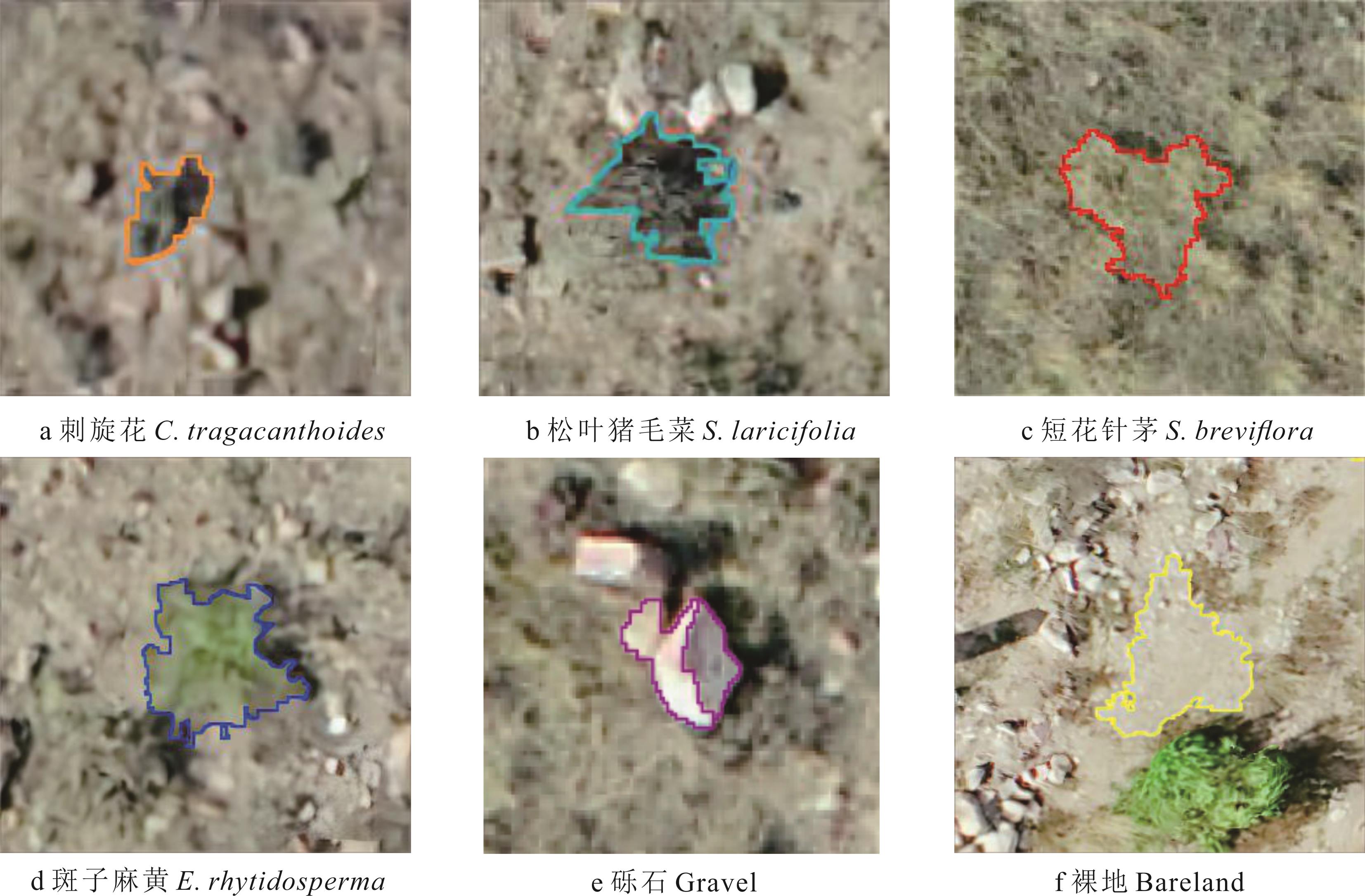
Fig.2 Typical samples of various features
| 类别Type | 特征名称Feature name | 数量Number |
|---|---|---|
光谱特征 Spectral feature | 红光波段标准差、绿光波段标准差、蓝光波段标准差、红光波段平均值、绿光波段平均值、蓝光波段平均值、色度、亮度值、饱和度、最大值Standard deviation-red, standard deviation-green, standard deviation-blue, mean-red, mean-green, mean-blue, hue, brightness, saturation, max | 10 |
纹理特征 Texture feature | 均值、方差、同质性、对比度、异质性、信息熵、能量(角二阶矩)、相关性Mean, variance, homogeneity, contrast, heterogeneity, entropy, angular second moment, correlation | 8 |
Table 1 Characteristic variable statistics
| 类别Type | 特征名称Feature name | 数量Number |
|---|---|---|
光谱特征 Spectral feature | 红光波段标准差、绿光波段标准差、蓝光波段标准差、红光波段平均值、绿光波段平均值、蓝光波段平均值、色度、亮度值、饱和度、最大值Standard deviation-red, standard deviation-green, standard deviation-blue, mean-red, mean-green, mean-blue, hue, brightness, saturation, max | 10 |
纹理特征 Texture feature | 均值、方差、同质性、对比度、异质性、信息熵、能量(角二阶矩)、相关性Mean, variance, homogeneity, contrast, heterogeneity, entropy, angular second moment, correlation | 8 |
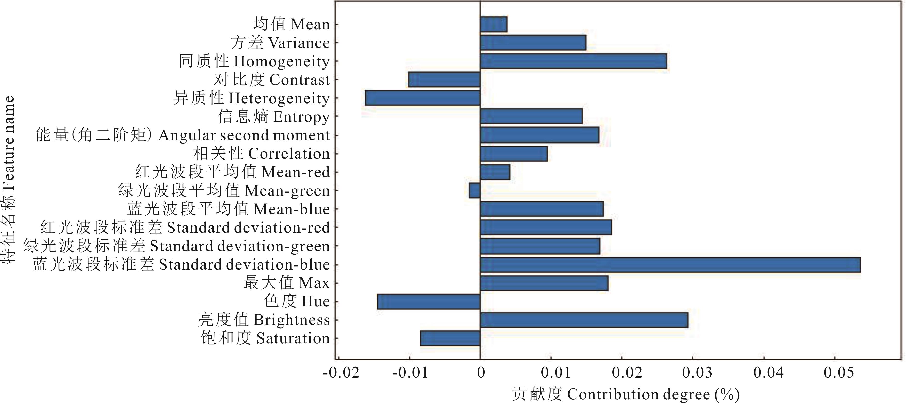
Fig.3 Feature importance weight
方案 Option | 特征名称 Feature name | 数量Number |
|---|---|---|
全部特征 All features | 红光波段标准差、绿光波段标准差、蓝光波段标准差、红光波段平均值、绿光波段平均值、蓝光波段平均值、色度、亮度值、饱和度、最大值、均值、方差、同质性、对比度、异质性、信息熵、能量(角二阶矩)、相关性Standard deviation-red, standard deviation-green, standard deviation-blue, mean-red, mean-green, mean-blue, hue, brightness, saturation, max, mean, variance, homogeneity, contrast, heterogeneity, entropy, angular second moment, correlation | 18 |
贡献度大于0 Contribution degree>0 | 红光波段标准差、绿光波段标准差、蓝光波段标准差、红光波段平均值、蓝光波段平均值、亮度值、最大值、均值、方差、同质性、信息熵、能量(角二阶矩)、相关性Standard deviation-red, standard deviation-green, standard deviation-blue, mean-red, mean-blue, brightness, max, mean, variance, homogeneity, entropy, angular second moment, correlation | 13 |
| 贡献度大于0.50% Contribution degree>0.50% | 蓝光波段平均值、红光波段标准差、绿光波段标准差、蓝光波段标准差、亮度值、最大值、方差、同质性、信息熵、能量(角二阶矩)、相关性Mean-blue, standard deviation-red, standard deviation-green, standard deviation-blue, brightness, max, variance, homogeneity, entropy, angular second moment, correlation | 11 |
| 贡献度大于1.00% Contribution degree>1.00% | 蓝光波段平均值、红光波段标准差、绿光波段标准差、蓝光波段标准差、亮度值、最大值、方差、同质性、信息熵、能量(角二阶矩)Mean-blue, standard deviation-red, standard deviation-green, standard deviation-blue, brightness, max, variance, homogeneity, entropy, angular second moment | 10 |
Table 2 Features contained in different feature combinations
方案 Option | 特征名称 Feature name | 数量Number |
|---|---|---|
全部特征 All features | 红光波段标准差、绿光波段标准差、蓝光波段标准差、红光波段平均值、绿光波段平均值、蓝光波段平均值、色度、亮度值、饱和度、最大值、均值、方差、同质性、对比度、异质性、信息熵、能量(角二阶矩)、相关性Standard deviation-red, standard deviation-green, standard deviation-blue, mean-red, mean-green, mean-blue, hue, brightness, saturation, max, mean, variance, homogeneity, contrast, heterogeneity, entropy, angular second moment, correlation | 18 |
贡献度大于0 Contribution degree>0 | 红光波段标准差、绿光波段标准差、蓝光波段标准差、红光波段平均值、蓝光波段平均值、亮度值、最大值、均值、方差、同质性、信息熵、能量(角二阶矩)、相关性Standard deviation-red, standard deviation-green, standard deviation-blue, mean-red, mean-blue, brightness, max, mean, variance, homogeneity, entropy, angular second moment, correlation | 13 |
| 贡献度大于0.50% Contribution degree>0.50% | 蓝光波段平均值、红光波段标准差、绿光波段标准差、蓝光波段标准差、亮度值、最大值、方差、同质性、信息熵、能量(角二阶矩)、相关性Mean-blue, standard deviation-red, standard deviation-green, standard deviation-blue, brightness, max, variance, homogeneity, entropy, angular second moment, correlation | 11 |
| 贡献度大于1.00% Contribution degree>1.00% | 蓝光波段平均值、红光波段标准差、绿光波段标准差、蓝光波段标准差、亮度值、最大值、方差、同质性、信息熵、能量(角二阶矩)Mean-blue, standard deviation-red, standard deviation-green, standard deviation-blue, brightness, max, variance, homogeneity, entropy, angular second moment | 10 |
分类方法 Classification method | 全部特征 All features | 贡献度大于0 Contribution degree>0 | 贡献度大于0.50% Contribution degree>0.50% | 贡献度大于1.00% Contribution degree>1.00% | ||||
|---|---|---|---|---|---|---|---|---|
| 总体分类精度Overall accuracy (%) | Kappa系数 Kappa coefficient | 总体分类精度Overall accuracy (%) | Kappa系数Kappa coefficient | 总体分类精度Overall accuracy (%) | Kappa系数Kappa coefficient | 总体分类精度Overall accuracy (%) | Kappa系数Kappa coefficient | |
| 分类回归树CART | 80.60 | 0.67 | 80.47 | 0.67 | 84.83 | 0.74 | 84.83 | 0.74 |
| K最邻近KNN | 83.83 | 0.73 | 83.68 | 0.72 | 84.29 | 0.73 | 84.29 | 0.73 |
| 随机森林RF | 86.29 | 0.76 | 85.63 | 0.75 | 86.77 | 0.78 | 87.77 | 0.79 |
| 支持向量机SVM | 65.54 | 0.46 | 63.53 | 0.47 | 86.24 | 0.76 | 86.24 | 0.76 |
Table 3 Compare the classification accuracy of different feature combinations and classification methods
分类方法 Classification method | 全部特征 All features | 贡献度大于0 Contribution degree>0 | 贡献度大于0.50% Contribution degree>0.50% | 贡献度大于1.00% Contribution degree>1.00% | ||||
|---|---|---|---|---|---|---|---|---|
| 总体分类精度Overall accuracy (%) | Kappa系数 Kappa coefficient | 总体分类精度Overall accuracy (%) | Kappa系数Kappa coefficient | 总体分类精度Overall accuracy (%) | Kappa系数Kappa coefficient | 总体分类精度Overall accuracy (%) | Kappa系数Kappa coefficient | |
| 分类回归树CART | 80.60 | 0.67 | 80.47 | 0.67 | 84.83 | 0.74 | 84.83 | 0.74 |
| K最邻近KNN | 83.83 | 0.73 | 83.68 | 0.72 | 84.29 | 0.73 | 84.29 | 0.73 |
| 随机森林RF | 86.29 | 0.76 | 85.63 | 0.75 | 86.77 | 0.78 | 87.77 | 0.79 |
| 支持向量机SVM | 65.54 | 0.46 | 63.53 | 0.47 | 86.24 | 0.76 | 86.24 | 0.76 |

Fig.4 Classification and regression tree (CART) classification results based on optimal features
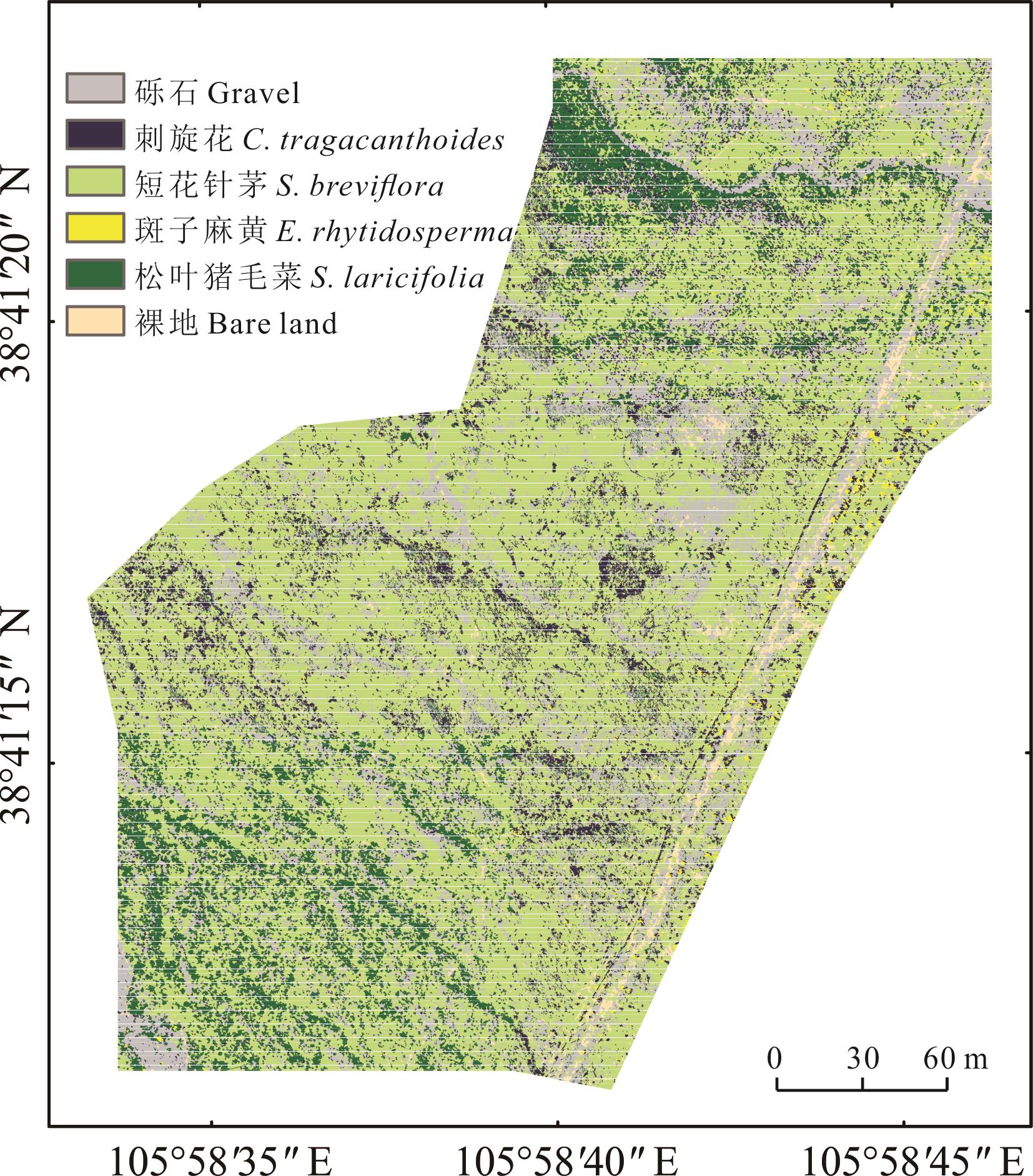
Fig.5 K-nearest neighbor (KNN) classification results based on optimal features

Fig.6 Random forest (RF) classification results based on optimal features
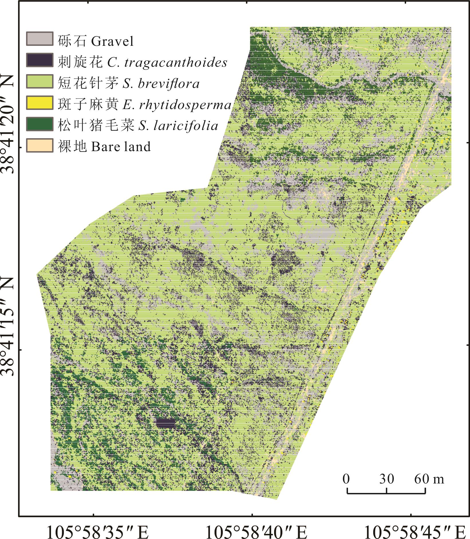
Fig.7 Support vector machine (SVM) classification results based on optimal features
方法 Method | 类别 Type | 砾石 Gravel | 斑子麻黄 E. rhytidosperma | 松叶猪毛菜 S. laricifolia | 刺旋花 C. tragacanthoides | 短花针茅 S. breviflora | 裸地 Bare land | 总体分类精度Overall accuracy (%) | Kappa系数 Kappa coefficient |
|---|---|---|---|---|---|---|---|---|---|
| 分类回归树CART | 砾石Gravel | 79.14 | 2.71 | 0.52 | 10.52 | 2.61 | 27.45 | 84.83 | 0.74 |
| 斑子麻黄E. rhytidosperma | 0.01 | 56.24 | 0.04 | 0.00 | 0.09 | 0.02 | |||
| 松叶猪毛菜S. laricifolia | 7.48 | 19.13 | 78.82 | 12.65 | 4.91 | 0.01 | |||
| 刺旋花C. tragacanthoides | 1.57 | 0.27 | 4.51 | 55.05 | 0.38 | 0.00 | |||
| 短花针茅S. breviflora | 10.63 | 21.62 | 15.68 | 21.72 | 91.47 | 6.24 | |||
| 裸地Bare land | 1.17 | 0.03 | 0.43 | 0.07 | 0.54 | 66.27 | |||
| K最邻近KNN | 砾石Gravel | 80.82 | 0.58 | 2.28 | 10.35 | 2.26 | 25.15 | 84.29 | 0.73 |
| 斑子麻黄E. rhytidosperma | 0.01 | 71.10 | 0.01 | 0.00 | 0.29 | 0.00 | |||
| 松叶猪毛菜S. laricifolia | 7.37 | 10.74 | 71.75 | 19.47 | 5.58 | 0.03 | |||
| 刺旋花C. tragacanthoides | 2.10 | 0.27 | 7.26 | 53.58 | 0.21 | 0.00 | |||
| 短花针茅S. breviflora | 7.81 | 16.77 | 18.29 | 16.47 | 91.54 | 5.35 | |||
| 裸地Bare land | 1.89 | 0.55 | 0.40 | 0.13 | 0.12 | 69.47 | |||
| 随机森林RF | 砾石Gravel | 82.90 | 0.69 | 0.26 | 6.34 | 1.78 | 31.72 | 87.77 | 0.79 |
| 斑子麻黄E. rhytidosperma | 0.00 | 27.58 | 0.00 | 0.00 | 0.00 | 0.00 | |||
| 松叶猪毛菜S. laricifolia | 8.23 | 12.60 | 81.23 | 19.53 | 2.66 | 0.03 | |||
| 刺旋花C. tragacanthoides | 0.93 | 0.18 | 1.65 | 57.61 | 0.24 | 0.00 | |||
| 短花针茅S. breviflora | 0.00 | 58.80 | 16.86 | 16.52 | 95.21 | 1.58 | |||
| 裸地Bare land | 0.41 | 0.13 | 0.01 | 0.00 | 0.11 | 66.67 | |||
| 支持向量机SVM | 砾石Gravel | 83.01 | 0.44 | 0.75 | 9.65 | 1.15 | 33.10 | 86.24 | 0.76 |
| 斑子麻黄E. rhytidosperma | 0.00 | 62.19 | 0.00 | 0.00 | 0.00 | 0.02 | |||
| 松叶猪毛菜S. laricifolia | 8.36 | 22.76 | 78.06 | 70.73 | 3.30 | 0.03 | |||
| 刺旋花C. tragacanthoides | 1.12 | 0.02 | 8.54 | 28.23 | 0.17 | 0.00 | |||
| 短花针茅S. breviflora | 6.35 | 14.45 | 12.64 | 16.74 | 95.36 | 5.92 | |||
| 裸地Bare land | 1.15 | 0.14 | 0.00 | 0.00 | 0.01 | 60.92 |
Table 4 Classification confusion matrix and precision comparison of different classification methods based on optimal features
方法 Method | 类别 Type | 砾石 Gravel | 斑子麻黄 E. rhytidosperma | 松叶猪毛菜 S. laricifolia | 刺旋花 C. tragacanthoides | 短花针茅 S. breviflora | 裸地 Bare land | 总体分类精度Overall accuracy (%) | Kappa系数 Kappa coefficient |
|---|---|---|---|---|---|---|---|---|---|
| 分类回归树CART | 砾石Gravel | 79.14 | 2.71 | 0.52 | 10.52 | 2.61 | 27.45 | 84.83 | 0.74 |
| 斑子麻黄E. rhytidosperma | 0.01 | 56.24 | 0.04 | 0.00 | 0.09 | 0.02 | |||
| 松叶猪毛菜S. laricifolia | 7.48 | 19.13 | 78.82 | 12.65 | 4.91 | 0.01 | |||
| 刺旋花C. tragacanthoides | 1.57 | 0.27 | 4.51 | 55.05 | 0.38 | 0.00 | |||
| 短花针茅S. breviflora | 10.63 | 21.62 | 15.68 | 21.72 | 91.47 | 6.24 | |||
| 裸地Bare land | 1.17 | 0.03 | 0.43 | 0.07 | 0.54 | 66.27 | |||
| K最邻近KNN | 砾石Gravel | 80.82 | 0.58 | 2.28 | 10.35 | 2.26 | 25.15 | 84.29 | 0.73 |
| 斑子麻黄E. rhytidosperma | 0.01 | 71.10 | 0.01 | 0.00 | 0.29 | 0.00 | |||
| 松叶猪毛菜S. laricifolia | 7.37 | 10.74 | 71.75 | 19.47 | 5.58 | 0.03 | |||
| 刺旋花C. tragacanthoides | 2.10 | 0.27 | 7.26 | 53.58 | 0.21 | 0.00 | |||
| 短花针茅S. breviflora | 7.81 | 16.77 | 18.29 | 16.47 | 91.54 | 5.35 | |||
| 裸地Bare land | 1.89 | 0.55 | 0.40 | 0.13 | 0.12 | 69.47 | |||
| 随机森林RF | 砾石Gravel | 82.90 | 0.69 | 0.26 | 6.34 | 1.78 | 31.72 | 87.77 | 0.79 |
| 斑子麻黄E. rhytidosperma | 0.00 | 27.58 | 0.00 | 0.00 | 0.00 | 0.00 | |||
| 松叶猪毛菜S. laricifolia | 8.23 | 12.60 | 81.23 | 19.53 | 2.66 | 0.03 | |||
| 刺旋花C. tragacanthoides | 0.93 | 0.18 | 1.65 | 57.61 | 0.24 | 0.00 | |||
| 短花针茅S. breviflora | 0.00 | 58.80 | 16.86 | 16.52 | 95.21 | 1.58 | |||
| 裸地Bare land | 0.41 | 0.13 | 0.01 | 0.00 | 0.11 | 66.67 | |||
| 支持向量机SVM | 砾石Gravel | 83.01 | 0.44 | 0.75 | 9.65 | 1.15 | 33.10 | 86.24 | 0.76 |
| 斑子麻黄E. rhytidosperma | 0.00 | 62.19 | 0.00 | 0.00 | 0.00 | 0.02 | |||
| 松叶猪毛菜S. laricifolia | 8.36 | 22.76 | 78.06 | 70.73 | 3.30 | 0.03 | |||
| 刺旋花C. tragacanthoides | 1.12 | 0.02 | 8.54 | 28.23 | 0.17 | 0.00 | |||
| 短花针茅S. breviflora | 6.35 | 14.45 | 12.64 | 16.74 | 95.36 | 5.92 | |||
| 裸地Bare land | 1.15 | 0.14 | 0.00 | 0.00 | 0.01 | 60.92 |
| 1 | Ye J Y. Remote sensing information extraction and inversion of vegetation in dryland areas. Beijing: Chinese Academy of Forestry, 2017. |
| 叶静芸. 旱区植被遥感信息提取与反演. 北京: 中国林业科学研究院, 2017. | |
| 2 | Fang K, Song N P, An H, et al. Quantitative classification and ordination of plant communities in a desert steppe in Yanchi County of Ningxia, Northwest China. Chinese Journal of Ecology, 2011, 30(12): 2719-2725. |
| 方楷, 宋乃平, 安慧, 等. 宁夏盐池荒漠草原植被的数量分类和排序. 生态学杂志, 2011, 30(12): 2719-2725. | |
| 3 | Wang G, Ding H X. Recognition of vegetation types in Leizhou peninsula based on Sentinel-2A data. Bulletin of Surveying and Mapping, 2022(3): 76-82. |
| 王刚, 丁华祥. Sentinel-2A数据支持下的雷州半岛植被类型识别. 测绘通报, 2022(3): 76-82. | |
| 4 | Huang Y F, Lu C Y, Jia M M, et al. Plant species classification of coastal wetlands based on UAV images and object-oriented deep learning. Biodiversity Science, 2023, 31(3): 143-158. |
| 黄雨菲, 路春燕, 贾明明, 等. 基于无人机影像与面向对象-深度学习的滨海湿地植物物种分类. 生物多样性, 2023, 31(3): 143-158. | |
| 5 | Sui J M, Song N P, Xue Y, et al. The method of extracting vegetation coverage in the desert steppe based on photographic. Chinese Journal of Grassland, 2019, 41(2): 58-64. |
| 随金明, 宋乃平, 薛毅, 等. 基于照相法的荒漠草原植被覆盖度测定方法. 中国草地学报, 2019, 41(2): 58-64. | |
| 6 | Baatz M. Object-oriented and multi-scale image analysis in semantic networks//Proceedings of the 2nd international symposium on operationalization of remote sensing. Enschede: International Trade Center, 1999. |
| 7 | Tian L J, Song W L, Lu Y Z, et al. Rapid monitoring and classification of landuse in agricultural areas by UAV based on deep learning method. Journal of China Institute of Water Resources and Hydropower Research, 2019, 17(4): 312-320. |
| 田琳静, 宋文龙, 卢奕竹, 等. 基于深度学习的农业区土地利用无人机监测分类. 中国水利水电科学研究院学报, 2019, 17(4): 312-320. | |
| 8 | Zhao Q Z, Jiang P, Wang X W, et al. Classification of protection forest tree species based on UAV hyperspectral data. Transactions of the Chinese Society for Agricultural Machinery, 2021, 52(11): 190-199. |
| 赵庆展, 江萍, 王学文, 等. 基于无人机高光谱遥感影像的防护林树种分类. 农业机械学报, 2021, 52(11): 190-199. | |
| 9 | Yan Y, Deng L, Liu X L, et al. Application of UAV-based multi-angle hyperspectral remote sensing in fine vegetation classification. Remote Sensing, 2019, 11(23): 2753. |
| 10 | Yang C X, Liu H H, Zhang C. UAV hyperspectral remote sensing image crop fine classification based on SVM and RF. Henan Science, 2020, 38(12): 1987-1995. |
| 阳昌霞, 刘汉湖, 张春. 基于SVM与RF的无人机高光谱农作物精细分类. 河南科学, 2020, 38(12): 1987-1995. | |
| 11 | Jiang Y F, Qi J G, Chen B W, et al. Classification of mangrove species with UAV hyperspectral imagery and machine learning methods. Remote Sensing Technology and Application, 2021, 36(6): 1416-1424. |
| 姜玉峰, 齐建国, 陈博伟, 等. 基于无人机高光谱影像和机器学习的红树林树种精细分类. 遥感技术与应用, 2021, 36(6): 1416-1424. | |
| 12 | Li F F, Liu Z J, Xu Q Q, et al. Application of object-oriented random forest method in wetland vegetation classification. Remote Sensing Information, 2018, 33(1): 111-116. |
| 李方方, 刘正军, 徐强强, 等. 面向对象随机森林方法在湿地植被分类的应用. 遥感信息, 2018, 33(1): 111-116. | |
| 13 | Shojanoori R, Shafri H Z M, Mansor S, et al. The use of WorldView-2 satellite data in urban tree species mapping by object-based image analysis technique. Sains Malaysiana, 2016, 45(7): 1025-1034. |
| 14 | Hao M Y, Qin L J, Mao P, et al. Unmanned aerial vehicle (UAV) based methodology for spatial distribution pattern analysis of desert vegetation. Journal of Desert Research, 2020, 40(6): 169-179. |
| 郝梦宇, 秦龙君, 毛鹏, 等. 基于无人机可见光影像的荒漠植被分布格局研究方法. 中国沙漠, 2020, 40(6): 169-179. | |
| 15 | Immitzer M, Atzberger C, Koukal T. Tree species classification with random forest using very high spatial resolution 8-band WorldView-2 satellite data. Remote Sensing, 2012, 4(9): 2661-2693. |
| 16 | Li F X. Application and discussion of UAV technology in ecological remote sensing monitoring of grassland. Bulletin of Surveying and Mapping, 2017(7): 99-102, 107. |
| 李风贤. 无人机技术在草原生态遥感监测中的应用与探讨. 测绘通报, 2017(7): 99-102, 107. | |
| 17 | Wang Y, Bi Y G. Simplified learning classification model based on UAV hyperspectral remote sensing for desert steppe terrain. Transactions of the Chinese Society for Agricultural Machinery, 2022, 53(11): 236-243. |
| 王圆, 毕玉革. 基于无人机高光谱的荒漠草原地物精简学习分类模型. 农业机械学报, 2022, 53(11): 236-243. | |
| 18 | Yang H Y, Du J M, Ruan P Y, et al. Vegetation classification of desert steppe based on unmanned aerial vehicle remote sensing and random forest. Transactions of the Chinese Society for Agricultural Machinery, 2021, 52(6): 186-194. |
| 杨红艳, 杜健民, 阮培英, 等. 基于无人机遥感与随机森林的荒漠草原植被分类方法. 农业机械学报, 2021, 52(6): 186-194. | |
| 19 | Liu B R. Changes in soil microbial biomass carbon and nitrogen under typical plant communies along an altitudinal gradient in east side of Helan Mountain, China. Ecology and Environmental Sciences, 2010, 19(4): 883-888. |
| 刘秉儒. 贺兰山东坡典型植物群落土壤微生物量碳、氮沿海拔梯度的变化特征. 生态环境学报, 2010, 19(4): 883-888. | |
| 20 | Su C, Ma W H, Zhang X Y, et al. Species composition and structure characteristics of the major montane shrub communities in the west slope of Helan Mountains, Nei Mongol, China. Chinese Journal of Plant Ecology, 2018, 42(10): 1050-1054. |
| 苏闯, 马文红, 张芯毓, 等. 贺兰山西坡主要山地灌丛群落的基本特征. 植物生态学报, 2018, 42(10): 1050-1054. | |
| 21 | Zhao L, Yang B, Liu W D, et al. Sex ratio and spatial pattern of Ephedra rhytidosperma in Helan Mountain of Ningxia. Acta Ecologica Sinica, 2022, 42(24): 10297-10304. |
| 赵玲, 杨博, 刘万弟, 等. 宁夏贺兰山斑子麻黄种群的性比及雌雄空间格局. 生态学报, 2022, 42(24): 10297-10304. | |
| 22 | Shi B, Dou J D, Huang W, et al. Community characteristics of Ephedra rhytidosperma in Helan Mountain of Ningxia, China. Chinese Journal of Plant Ecology, 2022, 46(3): 362-367. |
| 师斌, 窦建德, 黄维, 等. 宁夏贺兰山斑子麻黄荒漠群落特征. 植物生态学报, 2022, 46(3): 362-367. | |
| 23 | Liang C Z, Zhu Z Y, Li Z G, et al. Vegetation of Helan Mountain. Yinchuan: Sunshine Press, 2012: 142-144. |
| 梁存柱, 朱宗元, 李志刚, 等. 贺兰山植被. 银川: 阳光出版社, 2012: 142-144. | |
| 24 | Liu B R, Zhang X Z, Hu T H, et al. Soil microbial diversity under typical vegetation zones along an elevation gradient in Helan Mountains. Acta Ecologica Sinica, 2013, 33(22): 7211-7220. |
| 刘秉儒, 张秀珍, 胡天华, 等. 贺兰山不同海拔典型植被带土壤微生物多样性. 生态学报, 2013, 33(22): 7211-7220. | |
| 25 | Dong X M, Zhang Y N, Li S H. Afforestation technology of different site types in piedmont diluvial fan at eastern foot of Helan Mountain. Modern Agricultural Science and Technology, 2013(17): 199. |
| 董新明, 张亚宁, 李生红. 贺兰山东麓山前洪积扇不同立地类型造林技术. 现代农业科技, 2013(17): 199. | |
| 26 | Dai J G, Zhang G S, Guo P, et al. Classification method of main crops in northern Xinjiang based on UAV visible waveband images. Transactions of the Chinese Society of Agricultural Engineering, 2018, 34(18): 122-129. |
| 戴建国, 张国顺, 郭鹏, 等. 基于无人机遥感可见光影像的北疆主要农作物分类方法. 农业工程学报, 2018, 34(18): 122-129. | |
| 27 | Zhang G H, Wang X J, Xu X L, et al. Desert vegetation classification based on object-oriented UAV remote sensing images. Journal of Agricultural Science and Technology, 2021, 23(5): 69-77. |
| 张冠宏, 王新军, 徐晓龙, 等. 基于面向对象的无人机遥感影像荒漠植被分类. 中国农业科技导报, 2021, 23(5): 69-77. | |
| 28 | Zhang S Y, Li Z F, Xu F, et al. Optimization of estuary wetland landscape classification based on multi-temporal UAV images. Chinese Journal of Ecology, 2020, 39(9): 3174-3184. |
| 张舒昱, 李兆富, 徐锋, 等. 基于多时相无人机遥感影像优化河口湿地景观分类. 生态学杂志, 2020, 39(9): 3174-3184. | |
| 29 | Wu Z C, Hu Z W, Zhang Q, et al. On combining spectral, textural and shape feature for remote sensing image segmentation. Acta Geodaetica et Cartographica Sinica, 2013, 42(1): 44-50. |
| 巫兆聪, 胡忠文, 张谦, 等. 结合光谱、纹理与形状结构信息的遥感影像分割方法. 测绘学报, 2013, 42(1): 44-50. | |
| 30 | Zhang W B, Kong J L, Yang Y Y, et al. Fine vegetation classification of remote sensing in arid areas based on object-oriented method. Science of Surveying and Mapping, 2021, 46(1): 136-140, 183. |
| 张文博, 孔金玲, 杨园园, 等. 面向对象的旱区植被遥感精细分类研究. 测绘科学, 2021, 46(1): 136-140, 183. | |
| 31 | Li Z, Zhang Q Y, Qiu X C, et al. Temporal stage and method selection of tree species classification based on GF-2 remote sensing image. Chinese Journal of Applied Ecology, 2019, 30(12): 4059-4070. |
| 李哲, 张沁雨, 邱新彩, 等. 基于高分二号遥感影像树种分类的时相及方法选择. 应用生态学报, 2019, 30(12): 4059-4070. | |
| 32 | Zhang M L, Zhou Z H. A review on multi-label learning algorithms. IEEETransactions on Knowledge and Data Engineering, 2013, 26(8): 1819-1837. |
| 33 | Xiao Y, Jiang Q G, Wang B, et al. Object based land-use classification based on hybrid feature selection method of combining ReliefF and PSO. Transactions of the Chinese Society of Agricultural Engineering, 2016, 32(4): 211-216. |
| 肖艳, 姜琦刚, 王斌, 等. 基于ReliefF和PSO混合特征选择的面向对象土地利用分类. 农业工程学报, 2016, 32(4): 211-216. | |
| 34 | Ding X M, Wang H J, Wang S G, et al. Unsupervised feature selection method based on improved ReliefF. Computer Systems Applications, 2018, 27(3): 149-155. |
| 丁雪梅, 王汉军, 王炤光, 等. 基于改进ReliefF的无监督特征选择方法. 计算机系统应用, 2018, 27(3): 149-155. | |
| 35 | Cheng Q Q, Wang L L, Zheng T, et al. Microblogg friend recommendation based on multi-feature classification. Computer Engineering, 2015, 41(4): 65-69, 80. |
| 程倩倩, 王路路, 郑涛, 等. 基于多特征分类的微博好友推荐. 计算机工程, 2015, 41(4): 65-69, 80. | |
| 36 | Vapnik V N. An overview of statistical learning theory. IEEE Transactions on Neural Networks, 1999, 10(5): 988-999. |
| 37 | Yang C, Wu G F, Li Q Q, et al. Research progress on remote sensing classification of vegetation. Geography and Geo-Information Science, 2018, 34(4): 24-32. |
| 杨超, 邬国锋, 李清泉, 等. 植被遥感分类方法研究进展. 地理与地理信息科学, 2018, 34(4): 24-32. | |
| 38 | Du P J, Xia J S, Xue Z H, et al. Review of hyperspectral remote sensing image classification. National Remote Sensing Bulletin, 2016, 20(2): 236-256. |
| 杜培军, 夏俊士, 薛朝辉, 等. 高光谱遥感影像分类研究进展. 遥感学报, 2016, 20(2): 236-256. | |
| 39 | Lv J X. Fall detection method research based on RGB-D image sequence. Shenyang: Shenyang Aerospace University, 2020. |
| 吕健雄. 基于RGB-D图像序列的摔倒检测方法研究. 沈阳: 沈阳航空航天大学, 2020. | |
| 40 | Tian Y, Jia M, Wang Z, et al. Monitoring invasion process of Spartina alterniflora by seasonal Sentinel-2 imagery and an object-based random forest classification. Remote Sensing, 2020, 12(9): 1383. |
| 41 | Moreno M Á, Camps V G, Kattge J, et al. A methodology to derive global maps of leaf traits using remote sensing and climate data. Remote Sensing of Environment, 2018, 218: 69-88. |
| 42 | Zhang L, Ning X. Two improvements on CART decision tree and its application. Computer Engineering and Design, 2015, 36(5): 1209-1213. |
| 张亮, 宁芊. CART决策树的两种改进及应用. 计算机工程与设计, 2015, 36(5): 1209-1213. | |
| 43 | Congalton R G. A review of assessing the accuracy of classifications of remotely sensed data. Remote Sensing of Environment, 1991, 37(1): 35-46. |
| 44 | Gao Z Z, Dai F H. Vegetation in Ningxia. Yinchuan: Ningxia People’s Publishing House, 1988: 245-246. |
| 高正中, 戴法和. 宁夏植被. 银川: 宁夏人民出版社, 1988: 245-246. | |
| 45 | Jing R, Deng L, Zhao W J, et al. Object-oriented aquatic vegetation extracting approach based on visible vegetation indices. Chinese Journal of Applied Ecology, 2016, 27(5): 1427-1436. |
| 井然, 邓磊, 赵文吉, 等. 基于可见光植被指数的面向对象湿地水生植被提取方法. 应用生态学报, 2016, 27(5): 1427-1436. | |
| 46 | Na M L, Li Y, Wang W Y, et al. Identification of typical species in desert steppe based on unmanned aerial vehicle multispectral images. China Agricultural Informatics, 2022, 34(2): 37-48. |
| 那木拉, 李渊, 王乌云, 等. 基于无人机多光谱影像的荒漠草原典型物种识别. 中国农业信息, 2022, 34(2): 37-48. | |
| 47 | Ballanti L, Blesius L, Hines E, et al. Tree species classification using hyperspectral imagery: A comparison of two classifiers. Remote Sensing, 2016, 8(6): 445. |
| 48 | Xie Z, Chen Y, Lu D, et al. Classification of land cover, forest, and tree species classes with ZiYuan-3 multispectral and stereo data. Remote Sensing, 2019, 11(2): 164. |
| 49 | Fang F, Mcneil B E, Warner T A, et al. Discriminating tree species at different taxonomic levels using multi-temporal WorldView-3 imagery in Washington DC, USA. Remote Sensing of Environment, 2020, 246: 111811. |
| 50 | Sankey T, Donager J, Mcvay J, et al. UAV lidar and hyperspectral fusion for forest monitoring in the southwestern USA. Remote Sensing of Environment, 2017, 195: 30-43. |
| 51 | Fu Y, Zhao C, Wang J, et al. An improved combination of spectral and spatial features for vegetation classification in hyperspectral images. Remote Sensing, 2017, 9(3): 261. |
| 52 | Cao J, Leng W, Liu K, et al. Object-based mangrove species classification using unmanned aerial vehicle hyperspectral images and digital surface models. Remote Sensing, 2018, 10(1): 89. |
| [1] | Rong-xia SU, Yan-ping MA, Hong-mei WANG, Ya-nan ZHAO, Zhi-li LI. Changes in soil bacterial carbon source utilization and soil extracellular enzyme activity after artificial planting of Caragana korshinskii at different densities on the desert steppe [J]. Acta Prataculturae Sinica, 2023, 32(11): 93-105. |
| [2] | Jiang-long SHEN, Ji-jun CHEN, Abuduwali IMAM, Kun YANG, Ya-ting GUO, Jiang-hua ZHENG. The relationship between attack by Prosodes dilaticollis and desert grassland changes in Xinjiang: A case study of southern mountain grassland in Changji [J]. Acta Prataculturae Sinica, 2022, 31(6): 163-177. |
| [3] | Rui HUA, Rui ZHOU, Daerhan BAO, Ke-chi DONG, Zhuang-sheng TANG, Li-min HUA. A study of UAV remote sensing technology for classifying the level of plateau pika damage to alpine rangeland [J]. Acta Prataculturae Sinica, 2022, 31(4): 165-176. |
| [4] | Zhong-chao SUN, Tian-dou GUO, Lu YU, Yan-ping MA, Ya-nan ZHAO, Xue-ying LI, Hong-mei WANG. Changes in soil particle size distribution and fractal characteristics across an anthropogenic transition from desert steppe grassland to shrubland in eastern Ningxia [J]. Acta Prataculturae Sinica, 2021, 30(4): 34-45. |
| [5] | Chen CHEN, Chang-qing JING, Wen-yuan XING, Xiao-jin DENG, Hao-yu FU, Wen-zhang GUO. Desert grassland dynamics in the last 20 years and its response to climate change in Xinjiang [J]. Acta Prataculturae Sinica, 2021, 30(3): 1-14. |
| [6] | Hui-xia LIU, Yi-qiang DONG, Yu-xuan CUI, Xing-hong LIU, Pan-xing HE, Qiang SUN, Zong-jiu SUN. Environmental factors influencing soil organic carbon and its characteristics in desert grassland in Altay, Xinjiang [J]. Acta Prataculturae Sinica, 2021, 30(10): 41-52. |
| [7] | YU Lu, ZHOU Yu-rong, ZHAO Ya-nan, GUO Tian-dou, SUN Zhong-chao, WANG Hong-mei. Responses of the soil seed bank to simulated rainfall levels and anthropogenically introduced shrub encroachment in the desert steppe [J]. Acta Prataculturae Sinica, 2020, 29(4): 41-50. |
| [8] | XIE Li, SONG Nai-ping, MENG Chen, WU Ting, CHEN Xiao-ying, LI Min-lan, YUE Jian-min. Time course of changes in soil particle size and carbon and nitrogen reserves after fencing Ningxia desert steppe [J]. Acta Prataculturae Sinica, 2020, 29(2): 1-10. |
| [9] | TIAN Meng, SUN Zong-jiu, LI Ying, LI Pei-ying, XIE Kai-yun. Response to increasing precipitation in Artemisia desert grassland of soil seed bank composition and species diversity of germinating plants [J]. Acta Prataculturae Sinica, 2019, 28(12): 17-28. |
| [10] | CHEN Yi-shi, SUN Hai-rong, LI Na-na, JIN Sheng-fei, CHE Zhao-bi, CAO Jia-min, LU Wei-hua. Plant community diversity in grazed Seriphidium semidesert grassland and its relationships with environmental factors [J]. Acta Prataculturae Sinica, 2019, 28(11): 1-11. |
| [11] | ZHANG Ya-rou, AN Hui, LIU Bing-ru, WEN Zhi-lin, WU Xiu-zhi, LI Qiao-ling, DU Zhong-yu. Effects of short-term nitrogen and phosphorus addition on soil labile organic carbon in desert grassland [J]. Acta Prataculturae Sinica, 2019, 28(10): 12-24. |
| [12] | AN Yu, AN Hui, LI Sheng-bing. Effects of grazing on ecological stoichiometry of soil and dominant plants in desert grassland [J]. Acta Prataculturae Sinica, 2018, 27(12): 94-102. |
| [13] | YAN Xin, LIU Ren-tao, AN Hui. Characterization of readily oxidizable carbon and dissolved organic carbon within the soil carbon pool during desertification of grassland in central China [J]. Acta Prataculturae Sinica, 2018, 27(11): 15-25. |
| [14] | Bademuqiqige, SUN Zong-jiu, LI Pei-ying, TIAN Meng, WU Yong-mei. Effect of increasing precipitation on seed germination characteristics in the soil seed banks of Seriphidium transiliense desert grassland [J]. Acta Prataculturae Sinica, 2018, 27(10): 136-146. |
| [15] | HAN Meng-Qi, PAN Zhan-Lei, JIN Yu-Xi, QIN Jie, LI Jiang-Wen, WANG Zhong-Wu, HAN Guo-Dong. Response of soil nitrogen mineralization to different stocking rates on the Stipa breviflora desert steppe [J]. Acta Prataculturae Sinica, 2017, 26(9): 27-35. |
| Viewed | ||||||
|
Full text |
|
|||||
|
Abstract |
|
|||||