

ISSN 1004-5759 CN 62-1105/S
草业学报 ›› 2021, Vol. 30 ›› Issue (4): 34-45.DOI: 10.11686/cyxb2020175
孙忠超1( ), 郭天斗1, 于露1, 马彦平1, 赵亚楠1, 李雪颖1, 王红梅1,2()
收稿日期:2020-04-14
修回日期:2020-05-11
出版日期:2021-04-20
发布日期:2021-03-16
通讯作者:
王红梅
作者简介:Corresponding author. E-mail: whm_826@163.com基金资助:
Zhong-chao SUN1(), Tian-dou GUO1, Lu YU1, Yan-ping MA1, Ya-nan ZHAO1, Xue-ying LI1, Hong-mei WANG1,2()
Received:2020-04-14
Revised:2020-05-11
Online:2021-04-20
Published:2021-03-16
Contact:
Hong-mei WANG
摘要:
以宁夏东部荒漠草原-人工灌丛地典型镶嵌区域为研究对象,根据生态界面理论,选取荒漠草地、草地边缘、灌丛边缘、灌丛地为主要转变样地,利用野外采样室内分析的方法,研究荒漠草原向灌丛地人为转变过程土壤性状、土壤粒径分形维数变化特征及其相互关系。结果表明,转变过程各样地土壤颗粒体积百分含量均表现为砂粒>粉粒>黏粒,且砂粒比例随着过渡逐渐增加,灌丛地最高,达98.97%;土壤分形维数变化介于1.02~2.58,随着转变过程呈降低趋势,抗土壤侵蚀能力逐渐降低,其中荒漠草地、草地边缘、灌丛边缘间无显著差异(P>0.05),但均显著高于灌丛地36.79%~41.48%(P<0.05)。土壤分形维数变化在转变过程中与黏粒含量(<2 μm)、粉粒含量(2~50 μm)呈显著正相关关系(P<0.05),与砂粒含量(50~2000 μm)呈显著负相关关系(P<0.05);与土壤水分含量、毛管孔隙度、有机碳含量、全磷含量呈极显著或显著正相关关系(P<0.01,P<0.05),与土壤容重呈极显著负相关关系(P<0.01)。主成分分析表明,土壤粉粒、土壤砂粒、土壤毛管孔隙度、土壤容重、土壤有机碳,土壤全磷在草地向灌丛地人为转变过程中对土壤粒径分形维数影响较大(P<0.05)。
孙忠超, 郭天斗, 于露, 马彦平, 赵亚楠, 李雪颖, 王红梅. 宁夏东部荒漠草原向灌丛地人为转变过程土壤粒径分形特征[J]. 草业学报, 2021, 30(4): 34-45.
Zhong-chao SUN, Tian-dou GUO, Lu YU, Yan-ping MA, Ya-nan ZHAO, Xue-ying LI, Hong-mei WANG. Changes in soil particle size distribution and fractal characteristics across an anthropogenic transition from desert steppe grassland to shrubland in eastern Ningxia[J]. Acta Prataculturae Sinica, 2021, 30(4): 34-45.
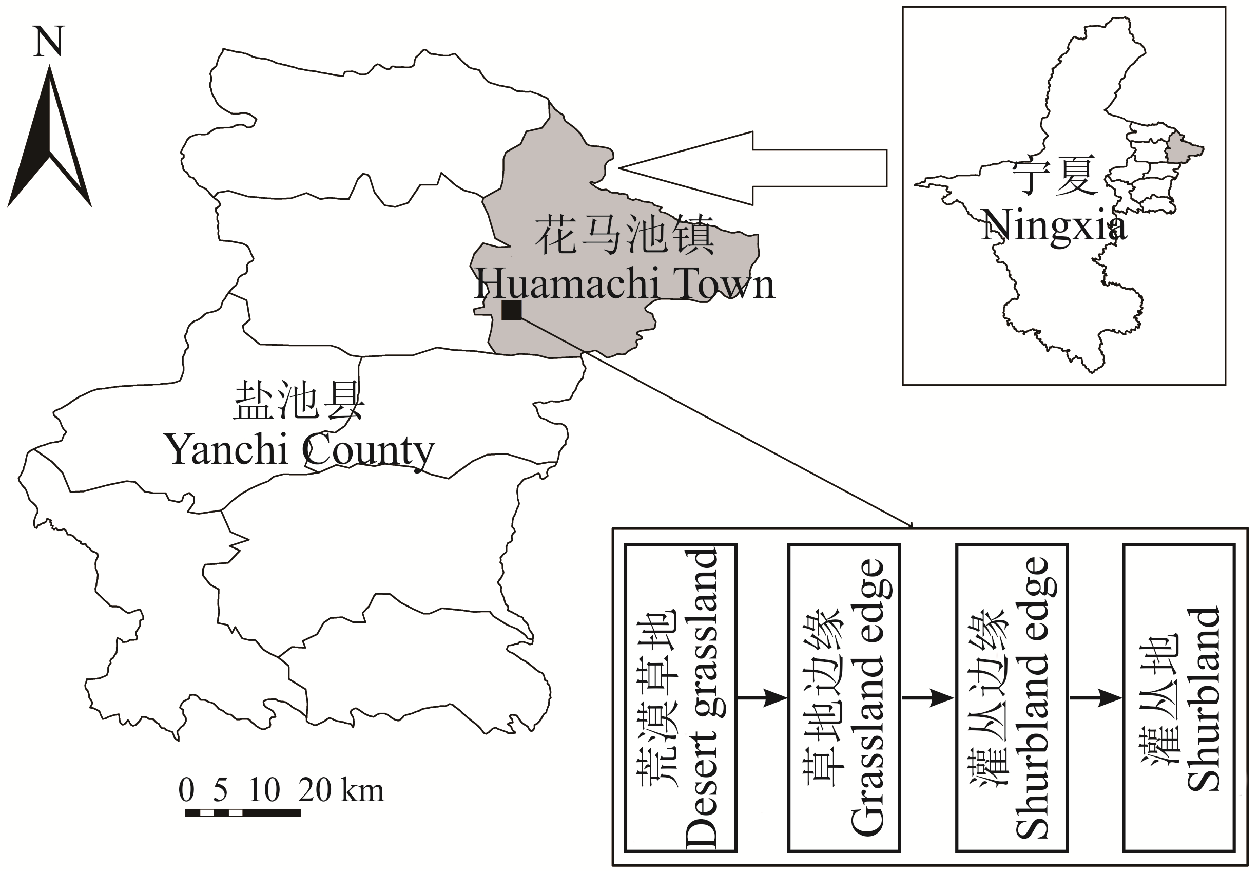
图1 研究区地理位置
Fig.1 Location of study area and site
样地 Site | 经纬度 Longitude and latitude | 灌木盖度Shrubs coverage (%) | pH | 草本盖度Herbage coverage (%) | 物种数Special number | 优势种 Dominant species |
|---|---|---|---|---|---|---|
荒漠草地 Desert grassland (DG) | 107°16′24″ E 37°46′31″ N | 0 | 8.35 | 70.0 | 25 | 蒙古冰草,短花针茅,猪毛蒿,刺藜A. mongolicum, S. breviflora, A. scoparia, Chenopodium aristatum |
草地边缘 Grassland edge (GE) | 107°16′08″ E 107°46′32″ N | 7.9 | 8.19 | 66.6 | 19 | 草木樨状黄芪,短花针茅,牛枝子,乳浆大戟Astragalus melilotoides, S. breviflora, L. potaninii, E. esula |
灌丛边缘 Shrubland edge (SE) | 107°17′43″ E 107°43′53″ N | 14.9 | 8.34 | 47.9 | 16 | 短花针茅,牛枝子,银灰旋花,远志S. breviflora, L. potaninii, C. ammannii, P. tenuifolia |
灌丛地 Shrubland (SL) | 107°17′52″ E 107°44′44″ N | 51.4 | 8.39 | 12.6 | 16 | 糙隐子草,猪毛蒿,地锦,狗尾草C. squarrosa, A. scoparia, Euphorbia humifusa, S. viridis |
表1 样地基本概况
Table 1 Descriptions of study sites
样地 Site | 经纬度 Longitude and latitude | 灌木盖度Shrubs coverage (%) | pH | 草本盖度Herbage coverage (%) | 物种数Special number | 优势种 Dominant species |
|---|---|---|---|---|---|---|
荒漠草地 Desert grassland (DG) | 107°16′24″ E 37°46′31″ N | 0 | 8.35 | 70.0 | 25 | 蒙古冰草,短花针茅,猪毛蒿,刺藜A. mongolicum, S. breviflora, A. scoparia, Chenopodium aristatum |
草地边缘 Grassland edge (GE) | 107°16′08″ E 107°46′32″ N | 7.9 | 8.19 | 66.6 | 19 | 草木樨状黄芪,短花针茅,牛枝子,乳浆大戟Astragalus melilotoides, S. breviflora, L. potaninii, E. esula |
灌丛边缘 Shrubland edge (SE) | 107°17′43″ E 107°43′53″ N | 14.9 | 8.34 | 47.9 | 16 | 短花针茅,牛枝子,银灰旋花,远志S. breviflora, L. potaninii, C. ammannii, P. tenuifolia |
灌丛地 Shrubland (SL) | 107°17′52″ E 107°44′44″ N | 51.4 | 8.39 | 12.6 | 16 | 糙隐子草,猪毛蒿,地锦,狗尾草C. squarrosa, A. scoparia, Euphorbia humifusa, S. viridis |
样地 Sample plot | 土壤深度 Soil depth (cm) | 土壤粒径体积百分含量 Volume percentage of soil particle size distribution (%) | 分形维数 Fractal dimension (D) | ||
|---|---|---|---|---|---|
| 黏粒Clay (<2 μm) | 粉粒Silt (2~50 μm) | 砂粒Sand (50~2000 μm) | |||
荒漠草地 Desert grassland (DG) | 0~10 | 0.01±0.01c | 28.20±0.93cd | 71.79±0.92bc | 2.25±0.05Abc |
| 10~20 | 0.78±0.78bc | 30.31±1.19bc | 68.91±1.97cd | 2.24±0.04Abc | |
| 20~40 | 3.46±0.10a | 35.56±0.10a | 60.98±0.19e | 2.42±0.00Aa | |
| 40~60 | 2.86±0.97a | 31.72±2.63b | 65.42±3.60d | 2.39±0.04Aab | |
| 60~80 | 0.94±0.50bc | 21.00±1.09e | 78.06±0.59a | 2.10±0.10Bc | |
| 80~100 | 1.42±0.05b | 25.36±2.59d | 73.22±2.55b | 2.32±0.03Bab | |
| 变异系数CV | 0.76 | 0.16 | 0.08 | 0.05 | |
草地边缘 Grassland edge (GE) | 0~10 | 0.04±0.00c | 29.81±0.10a | 70.15±0.09cd | 2.26±0.02Abc |
| 10~20 | 0.31±0.27c | 27.82±2.08ab | 71.87±1.82c | 2.24±0.01Ac | |
| 20~40 | 2.27±0.31b | 24.94±0.22c | 72.79±0.09c | 2.35±0.01Aab | |
| 40~60 | 3.85±1.62a | 27.28±1.93b | 68.87±3.55d | 2.44±0.05Aa | |
| 60~80 | 0.01±0.01c | 18.13±0.44d | 81.86±0.45b | 2.11±0.02Bc | |
| 80~100 | 0.00±0.00c | 13.51±0.86e | 86.49±0.86a | 1.96±0.06Cd | |
| 变异系数CV | 1.37 | 0.25 | 0.09 | 0.07 | |
灌丛边缘 Shrub edge (SE) | 0~10 | 0.00±0.00c | 3.94±0.21d | 96.06±0.21a | 1.42±0.11Bc |
| 10~20 | 0.00±0.00c | 7.88±4.16d | 92.12±4.16a | 1.52±0.17Bc | |
| 20~40 | 0.43±0.41c | 23.27±0.23c | 76.30±0.63b | 2.13±0.04Bb | |
| 40~60 | 7.32±2.73a | 44.10±5.43b | 48.58±8.15c | 2.58±0.06Aa | |
| 60~80 | 4.11±1.31b | 49.04±4.43ab | 46.85±5.74cd | 2.51±0.04Aa | |
| 80~100 | 6.23±0.40ab | 53.55±2.10a | 40.22±1.70d | 2.58±0.00Aa | |
| 变异系数CV | 1.00 | 0.65 | 0.34 | 0.23 | |
灌丛地 Shrub land (SL) | 0~10 | 0.00±0.00a | 4.27±1.87a | 95.73±1.86b | 1.45±0.10Bab |
| 10~20 | 0.00±0.00a | 2.24±0.17ab | 97.76±0.16ab | 1.39±0.06Bbc | |
| 20~40 | 0.00±0.00a | 1.39±0.33b | 98.61±0.33a | 1.78±0.05Ca | |
| 40~60 | 0.00±0.00a | 2.26±0.95ab | 97.74±0.95ab | 1.07±0.18Bcd | |
| 60~80 | 0.00±0.00a | 4.46±2.98a | 95.54±2.98b | 1.35±0.15Cbcd | |
| 80~100 | 0.00±0.00a | 1.03±0.00b | 98.97±0.00a | 1.02±0.08Dd | |
| 变异系数CV | 0 | 0.51 | 0.01 | 0.19 | |
表2 荒漠草原向灌丛地人为转变过程土壤粒径分布及分形维数
Table 2 Soil particle size distribution and its fractal dimension in different desert grassland-shrubland transition stages
样地 Sample plot | 土壤深度 Soil depth (cm) | 土壤粒径体积百分含量 Volume percentage of soil particle size distribution (%) | 分形维数 Fractal dimension (D) | ||
|---|---|---|---|---|---|
| 黏粒Clay (<2 μm) | 粉粒Silt (2~50 μm) | 砂粒Sand (50~2000 μm) | |||
荒漠草地 Desert grassland (DG) | 0~10 | 0.01±0.01c | 28.20±0.93cd | 71.79±0.92bc | 2.25±0.05Abc |
| 10~20 | 0.78±0.78bc | 30.31±1.19bc | 68.91±1.97cd | 2.24±0.04Abc | |
| 20~40 | 3.46±0.10a | 35.56±0.10a | 60.98±0.19e | 2.42±0.00Aa | |
| 40~60 | 2.86±0.97a | 31.72±2.63b | 65.42±3.60d | 2.39±0.04Aab | |
| 60~80 | 0.94±0.50bc | 21.00±1.09e | 78.06±0.59a | 2.10±0.10Bc | |
| 80~100 | 1.42±0.05b | 25.36±2.59d | 73.22±2.55b | 2.32±0.03Bab | |
| 变异系数CV | 0.76 | 0.16 | 0.08 | 0.05 | |
草地边缘 Grassland edge (GE) | 0~10 | 0.04±0.00c | 29.81±0.10a | 70.15±0.09cd | 2.26±0.02Abc |
| 10~20 | 0.31±0.27c | 27.82±2.08ab | 71.87±1.82c | 2.24±0.01Ac | |
| 20~40 | 2.27±0.31b | 24.94±0.22c | 72.79±0.09c | 2.35±0.01Aab | |
| 40~60 | 3.85±1.62a | 27.28±1.93b | 68.87±3.55d | 2.44±0.05Aa | |
| 60~80 | 0.01±0.01c | 18.13±0.44d | 81.86±0.45b | 2.11±0.02Bc | |
| 80~100 | 0.00±0.00c | 13.51±0.86e | 86.49±0.86a | 1.96±0.06Cd | |
| 变异系数CV | 1.37 | 0.25 | 0.09 | 0.07 | |
灌丛边缘 Shrub edge (SE) | 0~10 | 0.00±0.00c | 3.94±0.21d | 96.06±0.21a | 1.42±0.11Bc |
| 10~20 | 0.00±0.00c | 7.88±4.16d | 92.12±4.16a | 1.52±0.17Bc | |
| 20~40 | 0.43±0.41c | 23.27±0.23c | 76.30±0.63b | 2.13±0.04Bb | |
| 40~60 | 7.32±2.73a | 44.10±5.43b | 48.58±8.15c | 2.58±0.06Aa | |
| 60~80 | 4.11±1.31b | 49.04±4.43ab | 46.85±5.74cd | 2.51±0.04Aa | |
| 80~100 | 6.23±0.40ab | 53.55±2.10a | 40.22±1.70d | 2.58±0.00Aa | |
| 变异系数CV | 1.00 | 0.65 | 0.34 | 0.23 | |
灌丛地 Shrub land (SL) | 0~10 | 0.00±0.00a | 4.27±1.87a | 95.73±1.86b | 1.45±0.10Bab |
| 10~20 | 0.00±0.00a | 2.24±0.17ab | 97.76±0.16ab | 1.39±0.06Bbc | |
| 20~40 | 0.00±0.00a | 1.39±0.33b | 98.61±0.33a | 1.78±0.05Ca | |
| 40~60 | 0.00±0.00a | 2.26±0.95ab | 97.74±0.95ab | 1.07±0.18Bcd | |
| 60~80 | 0.00±0.00a | 4.46±2.98a | 95.54±2.98b | 1.35±0.15Cbcd | |
| 80~100 | 0.00±0.00a | 1.03±0.00b | 98.97±0.00a | 1.02±0.08Dd | |
| 变异系数CV | 0 | 0.51 | 0.01 | 0.19 | |
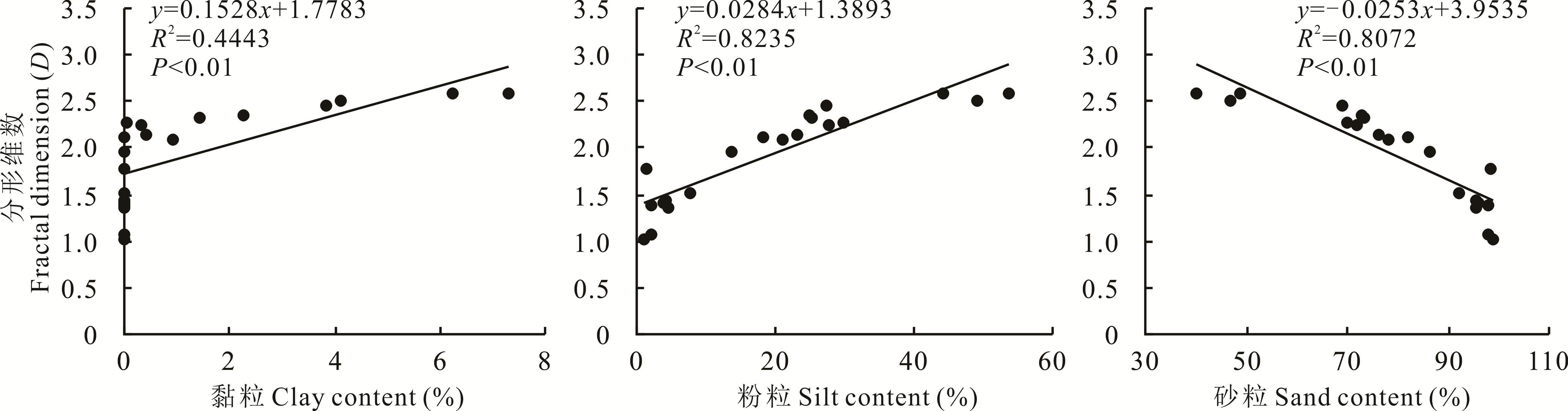
图2 分形维数D值与不同土壤粒径体积百分数的关系
Fig.2 Correlation between D value of fractal dimension and volumetric content of soil particle size

图3 荒漠草原向灌丛地人为转变过程土壤理化性质误差线由样地之间指标均值可得且表示各样地间差异显著(P<0.05)。The error bar is obtained from the average value of the indexes between the plots and indicates that the differences between the plots are significant (P<0.05).
Fig.3 Soil physical and chemical properties in the process of anthropogenic transition from desert steppe to shrub land
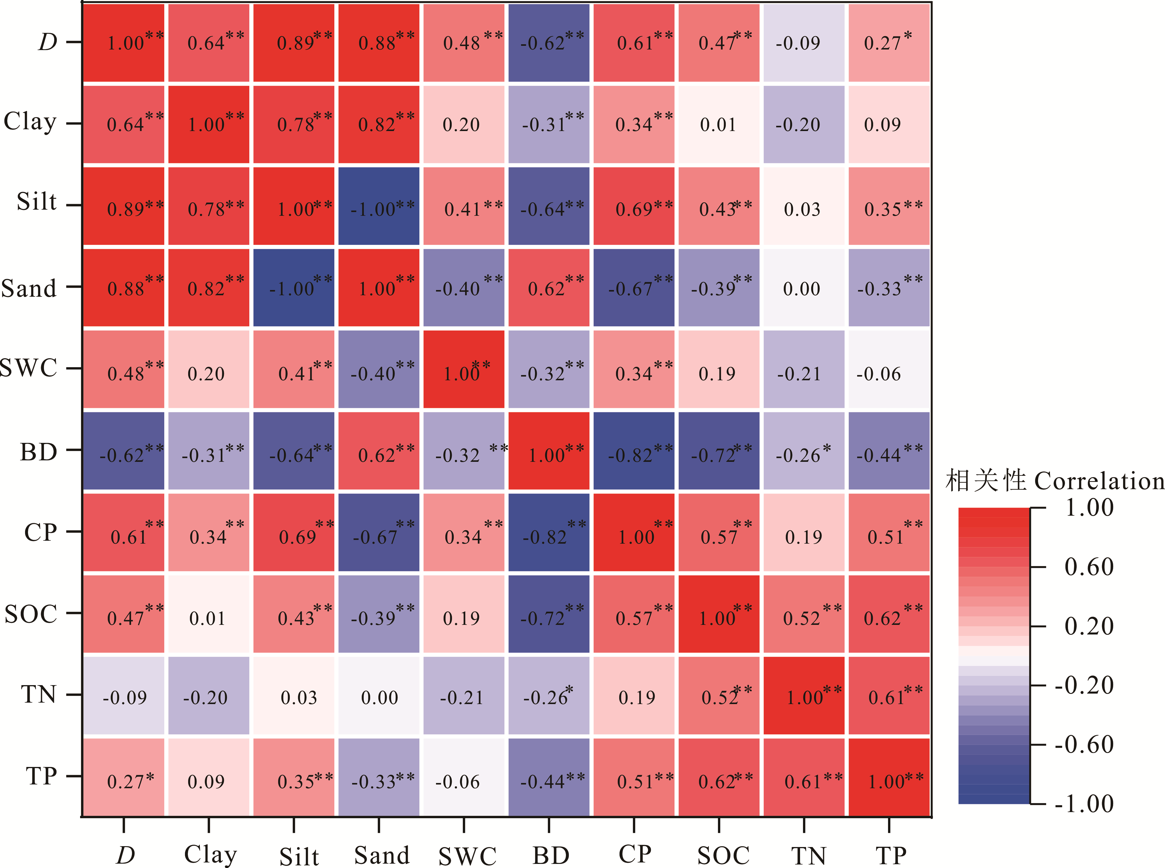
图4 0~100 cm 土层土壤粒径分布与土壤理化性质的相关系数*: P<0.05 ,**: P<0.01. D: 分形维数Soil fractal dimension; Clay: 黏粒; Silt: 粉粒; Sand: 砂粒; SWC: 土壤水分含量 Soil water content; BD: 容重 Bulk density; CP: 毛管孔隙度Capillary porosity; SOC: 土壤有机碳 Soil organic carbon; TN: 全氮 Total nitrogen; TP: 全磷 Total phosphorus.下同 The same below.
Fig.4 Correlation coefficient of soil particle size distribution of 0-100 cm soil layer and soil physical and chemical properties

图5 土壤理化性质与分形维数的主成分分析
Fig.5 Principal component analysis of soil physical and chemical properties and fractal dimension
| 1 | Li X Y, Yang Z P, Li Y T, et al. Connecting ecohydrology and hydropedology in desert shrubs: Stemflow as a source of preferential flow in soils. Hydrology & Earth System Sciences, 2009, 13(7): 1133-1144. |
| 2 | Okin G S, Gillerre D A, Herrick J E. Multi-scale controls on and consequences of aeolian processes in landscape change in arid and semi-arid environments. Journal of Arid Environment, 2006, 65(2): 253-275. |
| 3 | Petrie M D, Collins S L, Swann A M, et al. Grassland to shrubland state transitions enhance carbon sequestration in the northern Chihuahuan Desert. Global Change Biology, 2015, 21(3): 1226-1235. |
| 4 | Eldridge D J, Maestre F T, Maltez-Mouro S, et al. A global database of shrub encroachment effects on ecosystem structure and functioning. Ecology, 2012, 93(11): 2499-2503. |
| 5 | Wu X D, Song N P, Pan J. Effect of shrub (Caragana intermedia) encroachment under different sandy habitats on content and distribution of soil organic carbon in desert grassland. Transactions of the Chinese Society of Agricultural Engineering, 2016, 32(10): 115-121. |
| 吴旭东, 宋乃平, 潘军. 不同沙地生境下柠条灌丛化对草地土壤有机碳含量及分布的影响. 农业工程学报, 2016, 32(10): 115-121. | |
| 6 | Perfect E, Kay B D. Application of fractal in soil and tillage research: A review. Soil and Tillage Research, 1995, 36(1/2): 1-20. |
| 7 | Liu X, Li Z, Li P. Particle fractal dimension and total phosphorus of soil in a typical watershed of Yangtze River, China. Environmental Earth Sciences, 2015, 73: 6091-6099. |
| 8 | Zhao C L, Shao M A, Jia X X, et al. Particle size distribution of soils (0-500 cm) in the Loess Plateau, China. Geoderma Regional, 2016, 7: 251-258. |
| 9 | Zhao M Y, Zhao W W, Liu Y X. Comparative analysis of soil particle size distribution a n d its influence factors in different scales a case study in the Loess Hilly-gully area. Acta Ecologica Sinica, 2015, 35(14): 4625-4632. |
| 赵明月, 赵文武, 刘源鑫. 不同尺度下土壤粒径分布特征及其影响因子-以黄土丘陵沟壑区为例. 生态学报, 2015, 35(14): 4625-4632. | |
| 10 | Wen X Y, Huang C M, Huang F Q, et al. Fractal dimensions of soil particles and related affecting factors from the valley of upper Minjiang River. Journal of South China Normal University (Natural Science Editon), 2011, 1(1): 80-86. |
| 文星跃, 黄成敏, 黄凤琴, 等. 岷江上游河谷土壤粒径分形维数及其影响因素. 华南师范大学学报(自然科学版), 2011, 1(1): 80-86. | |
| 11 | Zhao W J, Cui Z, Ma H. Fractal features of soil particle-size distributions and their relationships with soil properties in gravel-mulched fields. Arabian Journal of Geosciences, 2017, 10(9): 1-7. |
| 12 | Filgueira R R, Fournier L L, Cerisola C I, et al. Particle-size distribution in soils: A critical study of the fractal model validation. Geoderma , 2006, 134(3): 327-334. |
| 13 | Wang J, Zhang M, Bai Z K, et al. Multi-fractal characteristics of the particle distribution of reconstructed soils and the relationship between soil properties and multi-fractal parameters in an opencast coal-mine dump in a loess area. Environmental Earth Sciences, 2015, 73(8): 4749-4762. |
| 14 | Zhao P, Shao M A, Zhuang J. Fractal features of particle size redistributions of deposited soils on the dam farmlands. Soil Science, 2009, 174(7): 403-407. |
| 15 | Gui D W, Lei J Q, Zeng F J. Ordination as a tool to characterize soil particle size distribution, applied to an elevation gradient at the north slope of the Middle Kunlun Mountains. Geoderma , 2010, 158(3): 352-358. |
| 16 | Jia M M, Zhang Z L, Lei J Q, et al. Fractal characteristics of soil particle size distribution in protection forest of Tarim Desert Highway. Arid Zone Research, 2015, 32(4): 674-679. |
| 17 | Bimueller C, Mueller C W, von Luetzow M, et al. Decoupled carbon and nitrogen mineralization in soil particle size fractions of a forest topsoil. Soil Biology & Biochemistry, 2014, 78(8): 263-273. |
| 18 | Zhou B B, Lu J B, Wang Q J, et al. Chloride transport in an aggregated clay soil column. Journal of Hydrologic Engineering, 2015, 20(11): 1943-5584. |
| 19 | Su Y Z, Zhao H L, Zhao W Z, et al. Fractal features of soil particle size distribution and the implication for indicating desertification. Geoderma, 2004, 122(1): 43-49. |
| 20 | Wang H M, Wang K. A review of edge detection and dynamic modeling of ecological boundaries. Acta Ecologica Sinica, 2017, 37(17): 5905-5914. |
| 王红梅, 王堃. 景观生态界面边界判定与动态模拟研究进展. 生态学报, 2017, 37(17): 5905-5914. | |
| 21 | Bao S D. Soil agro-chemistrical analysis (the third editon). Beijing: China Agricultural Press, 2005: 25-109. |
| 鲍士旦. 土壤农化分析(第三版). 北京: 中国农业出版社, 2005: 25-109. | |
| 22 | Tyler S W, Wheat-craft S W. Fractal scaling of soil particle size distribution: Analysis and limitations. Soil Science Society of America Journal, 1992, 56(2): 362-369. |
| 23 | Yang P L, Luo Y P, Shi Y C. Soil fractal chara cteri stics measured by mass of particle-size distribution. Chinese Science Bulletin, 1993, 38(20): 1896-1899. |
| 杨培岭, 罗远培, 石元春. 用粒径的重量分布表征的土壤分形特征. 科学通报, 1993, 38(20): 1896-1899. | |
| 24 | Wang G L, Zhou S L, Zhao Q G. Volume fractal dimension of soil particles and volume fractal dimension of soil particles and its applications to land use. Acta Pedologica Sinica, 2005, 42(4): 545-550. |
| 王国梁, 周生路, 赵其国. 土壤颗粒的体积分形维数及其在土地利用中的应用. 土壤学报, 2005, 42(4): 545-550. | |
| 25 | Porporato A, D’Odorico P, Laio F, et al. Ecohydrology of water-controlled ecosystems. Advances in Water Resources, 2002, 25: 1335-1348. |
| 26 | Xu M X, Liu G B, Zhao Y G. Effects of land use and environmental factors on the variability of soil quality indicators hilly Loess Plateau region of China. Chinese Journal of Applied Ecology, 2011, 22(2): 409-417. |
| 许明祥, 刘国彬, 赵允格. 黄土丘陵区土地利用及环境因子对土壤质量指标变异性的影响. 应用生态学报, 2011, 22(2): 409-417. | |
| 27 | Yan X, An H. Fractal features of soil particle size in the process of desertification in desert grassland of Ningxia, China. Chinese Journal of Applied Ecology, 2017, 28(10): 3243-3250. |
| 阎欣, 安慧. 宁夏荒漠草原沙漠化过程中土壤粒径分形特征. 应用生态学报, 2017, 28(10): 3243-3250. | |
| 28 | Zhang J R, Wang J M, Zhu Y C, et al. Application of fractal theory on pedology: A review. Chinese Journal of Soil Science, 2017, 48(1): 221-228. |
| 张佳瑞, 王金满, 祝宇成, 等. 分形理论在土壤学应用中的研究进展. 土壤通报, 2017, 48(1): 221-228. | |
| 29 | Fu Y L, Zhang X C, Wang J G. Fractal dimension of soil particle-size distribution characteristics in dry valley of upper Minjiang river. Transactions of the Chinese Society of Agricultural Engineering, 2012, 28(5): 120-125. |
| 伏耀龙, 张兴昌, 王金贵. 岷江上游干旱河谷土壤粒径分布分形维数特征. 农业工程学报, 2012, 28(5): 120-125. | |
| 30 | Peng W Y, Zhang K L, Chen Y, et al. Research on soil quality change after returning farmland to forest on the loess sloping croplands. Journal of Natural Resources, 2005, 20(2): 272-278. |
| 彭文英, 张科利, 陈瑶, 等. 黄土坡耕地退耕还林后土壤性质变化研究. 自然资源学报, 2005, 20(2): 272-278. | |
| 31 | Feng S Z, Su Y R, Zhang W, et al. Effects of slope position and soil horizon on soil microbial biomass and abundance in Karst primary forest of southwest China. Environmental Science, 2015, 36(10): 3832-3838. |
| 冯书珍, 苏以荣, 张伟, 等. 坡位与土层对喀斯特原生林土壤微生物生物量与丰度的影响. 环境科学, 2015, 36(10): 3832-3838. | |
| 32 | Su Y Z, Zhao H L. Fractal features of soil particle size distribution in the desertification process of the farmland in Horsing Sandy Land. Acta Ecologica Sinica, 2004, 24(1): 71-74. |
| 苏永中, 赵哈林. 科尔沁沙地农田沙漠化演变中土壤颗粒分形特征. 生态学报, 2004, 24(1): 71-74. | |
| 33 | Huang C Y. Soil science. Beijing: China Agriculture Press, 2010. |
| 黄昌勇. 土壤科学. 北京: 中国农业出版社, 2010. | |
| 34 | Luo Y X, Liu R T, Zhang J, et al. Soil particle composition, fractal dimension and their effects on soil properties following sand-binding revegetation within straw checkerboard in Tengger Desert, China. Chinese Journal of Applied Ecology, 2019, 30(2): 525-535. |
| 罗雅曦, 刘任涛, 张静, 等. 腾格里沙漠草方格固沙林土壤颗粒组成、分形维数及其对土壤性质的影响.应用生态学报, 2019, 30(2): 525-535. | |
| 35 | Bai Y R, Wang Y Q, Zhan X L. Effects of different land use types on soil physical properties and their distributions in farming-pastoral ecotone of Northern Shanxi. Scientia Agricultura Sinica, 2013, 46(8): 1619-1627. |
| 白一茹, 王幼奇, 展秀丽. 陕北农牧交错带土地利用方式对土壤物理性质及分布特征的影响. 中国农业科学, 2013, 46(8): 1619-1627. | |
| 36 | Cheng X F, Shi X Z. Application of fractal geometry in pedology and its prospects. Soils, 2003, 35(6): 461-464. |
| 程先富, 史学正. 分形几何在土壤学中的应用及其展望. 土壤, 2003, 35(6): 461-464. | |
| 37 | Xiao L X. Fractal characteristics of soil particle size distribution and nutrient content of four forests types in subtropical area. Changsha: Central South University of Forestry and Technology, 2015. |
| 肖灵香. 亚热带4种森林类型土壤粒径分布的分形特征与养分含量. 长沙: 中南林业科技大学, 2015. | |
| 38 | Chen L, Yang X G, Song N P, et al. Fractal features of soil particle size distribution in alfalfa grassland with different planting years of sandy area. Soil and Water Conservation in China, 2014(10): 54-57. |
| 陈林, 杨新国, 宋乃平, 等. 风沙区不同种植年限苜蓿地土壤团粒组成分形特征研究. 中国水土保持, 2014(10): 54-57. |
| [1] | 蒙仲举, 陈颜洁, 包斯琴. 苏尼特右旗荒漠草原三种放牧方式下群落斑块特征[J]. 草业学报, 2021, 30(4): 13-23. |
| [2] | 顾继雄, 郭天斗, 王红梅, 李雪颖, 梁丹妮, 杨青莲, 高锦月. 宁夏东部荒漠草原向灌丛地转变过程土壤微生物响应[J]. 草业学报, 2021, 30(4): 46-57. |
| [3] | 张丽星, 海春兴, 常耀文, 高晓媚, 高文邦, 解云虎. 羊草及芨芨草草原和西北针茅草原土壤质量评价[J]. 草业学报, 2021, 30(4): 68-79. |
| [4] | 张超, 闫瑞瑞, 梁庆伟, 娜日苏, 李彤, 杨秀芳, 包玉海, 辛晓平. 不同利用方式下草地土壤理化性质及碳、氮固持研究[J]. 草业学报, 2021, 30(4): 90-98. |
| [5] | 李洁, 潘攀, 王长庭, 胡雷, 陈科宇, 杨文高. 三江源区不同建植年限人工草地根系动态特征[J]. 草业学报, 2021, 30(3): 28-40. |
| [6] | 刘斯莉, 王长庭, 张昌兵, 胡雷, 唐立涛, 潘攀. 川西北高原3种禾本科牧草根系特征比较研究[J]. 草业学报, 2021, 30(3): 41-53. |
| [7] | 熊梅, 乔荠瑢, 杨阳, 张峰, 郑佳华, 吴建新, 赵萌莉. 不同载畜率下短花针茅和土壤生态化学计量特征研究[J]. 草业学报, 2021, 30(2): 212-219. |
| [8] | 张静静, 刘尊驰, 鄢创, 王云霞, 刘凯, 时新荣, 袁志友. 土壤pH值变化对3种草原类型土壤碳氮磷生态化学计量特征的影响[J]. 草业学报, 2021, 30(2): 69-81. |
| [9] | 李静, 红梅, 闫瑾, 张宇晨, 梁志伟, 叶贺, 高海燕, 赵巴音那木拉. 短花针茅荒漠草原植被群落结构及生物量对水氮变化的响应[J]. 草业学报, 2020, 29(9): 38-48. |
| [10] | 万芳, 蒙仲举, 党晓宏, 王瑞东, 张慧敏. 封育措施下荒漠草原针茅植物-土壤C、N、P化学计量特征[J]. 草业学报, 2020, 29(9): 49-55. |
| [11] | 王琇瑜, 黄晓霞, 和克俭, 孙晓能, 吕曾哲舟, 张勇, 朱湄, 曾睿钦. 滇西北高寒草甸植物群落功能性状与土壤理化性质的关系[J]. 草业学报, 2020, 29(8): 6-17. |
| [12] | 孙世贤, 丁勇, 李夏子, 吴新宏, 闫志坚, 尹强, 李金卓. 放牧强度季节调控对荒漠草原土壤风蚀的影响[J]. 草业学报, 2020, 29(7): 23-29. |
| [13] | 董雪, 郝玉光, 辛智鸣, 段瑞兵, 黄雅茹, 李新乐, 马媛, 刘芳. 浑善达克沙地3种灌木土壤分形特征与养分关系[J]. 草业学报, 2020, 29(6): 172-181. |
| [14] | 于露, 周玉蓉, 赵亚楠, 郭天斗, 孙忠超, 王红梅. 荒漠草原土壤种子库对灌丛引入和降水梯度的响应特征[J]. 草业学报, 2020, 29(4): 41-50. |
| [15] | 许爱云, 许冬梅, 曹兵, 刘金龙, 于双, 郭艳菊, 马晓静. 宁夏荒漠草原不同群落蒙古冰草种群空间格局及种间关联性[J]. 草业学报, 2020, 29(3): 171-178. |
| 阅读次数 | ||||||
|
全文 |
|
|||||
|
摘要 |
|
|||||