
ISSN 1004-5759 CN 62-1105/S
Acta Prataculturae Sinica ›› 2023, Vol. 32 ›› Issue (8): 91-103.DOI: 10.11686/cyxb2022359
Previous Articles Next Articles
Hu-cheng XING1,2( ), Xian-fang WANG2, Qing ZHOU3, Jing-cai YAN4, Yu-cheng JIE1,2()
Received:2022-09-08
Revised:2022-10-20
Online:2023-08-20
Published:2023-06-16
Contact:
Yu-cheng JIE
Hu-cheng XING, Xian-fang WANG, Qing ZHOU, Jing-cai YAN, Yu-cheng JIE. Types, grades, and utilization of grassland resources in 52 counties of Hunan Province[J]. Acta Prataculturae Sinica, 2023, 32(8): 91-103.

Fig.1 Distribution map of grassland sample points in 52 counties

Fig.2 Types and distribution of rangeland in 52 counties
| 草地类型Grass type | 面积Area (hm2) | 占比Proportion (%) | 草地型Grassland type |
|---|---|---|---|
| E02 | 5.13 | 0.03 | 白羊草B. ischaemum |
| E04 | 7.77 | 0.04 | 黄背草T. japonica |
| E05 | 42.00 | 0.23 | 黄背草、白茅T. japonica,I. cylindrica |
| E07 | 18.70 | 0.10 | 具灌木的荩草A. hispidus with shrubs |
| E08 | 8.32 | 0.05 | 具灌木的野古草、暖性禾草A. anomala and warm grass with shrubs |
| E10 | 2.55 | 0.01 | 结缕草Z. japonica |
| E11 | 2.16 | 0.01 | 具灌木的苔草、暖性禾草Wild sedge and warm grass with shrubs |
| E12 | 5.33 | 0.03 | 具灌木的白莲蒿Artemisia stechmanniana with shrubs |
| F01 | 513.00 | 2.83 | 芒、热性禾草M. sinensis, hot grass |
| F02 | 512.23 | 2.82 | 具乔灌的芒M. sinensis with trees and shrubs |
| F03 | 607.31 | 3.34 | 五节芒M. floridulus |
| F04 | 57.37 | 0.32 | 具乔灌的五节芒 M. floridulus with trees and shrubs |
| F05 | 3496.58 | 19.26 | 白茅I. cylindrica |
| F06 | 102.04 | 0.56 | 具灌木的白茅I. cylindrica with shrubs |
| F07 | 355.82 | 1.96 | 具乔木的白茅、芒I. cylindrica and M. sinensis with trees |
| F08 | 55.19 | 0.30 | 野古草A. anomala |
| F09 | 4.67 | 0.03 | 具乔灌的野古草、热性禾草A. anomala and hot grass with trees and shrubs |
| F11 | 56.49 | 0.31 | 具乔灌的金茅Eulalia speciosa with trees and shrubs |
| F13 | 21.27 | 0.12 | 旱茅E. delavayi |
| F16 | 16.41 | 0.09 | 橘草C. goeringii |
| F19 | 3.66 | 0.02 | 细毛鸭嘴草I. indicum |
| F22 | 2.26 | 0.01 | 扭黄茅H. contortus |
| F27 | 10.00 | 0.06 | 狼尾草P. alopecuroides |
| F28 | 1.92 | 0.01 | 葛藤P. lobata |
| G01 | 6637.98 | 36.56 | 芦苇P. australis |
| G02 | 3029.34 | 16.68 | 芦苇、藨草P. australis, S. triqueter |
| G03 | 1.60 | 0.01 | 具乔灌的芦苇、大叶白麻P. australis and Poacynum hendersonii with trees and shrubs |
| G09 | 6.68 | 0.04 | 碱茅Puccinellia distans |
| G10 | 1.42 | 0.01 | 巨序剪股颖、拂子茅Agrostis gigantea, Calamagrostis epigeios |
| G11 | 546.26 | 3.01 | 狗牙根,假俭草C. dactylon, E. ophiuroides |
| G13 | 568.75 | 3.13 | 乌拉苔草Carex meyeriana |
| G14 | 498.32 | 2.74 | 莎草、杂类草C. rotundus and weeds |
| G19 | 934.75 | 5.15 | 匍匐柳叶箬I. repens |
| H01 | 21.36 | 0.12 | 荻T. sacchariflora |
| H13 | 3.89 | 0.02 | 早熟禾、杂类草P. annua and weeds |
| 合计Sum | 18158.54 | 100.00 |
Table 1 Statistics on rangeland type and area in 52 counties
| 草地类型Grass type | 面积Area (hm2) | 占比Proportion (%) | 草地型Grassland type |
|---|---|---|---|
| E02 | 5.13 | 0.03 | 白羊草B. ischaemum |
| E04 | 7.77 | 0.04 | 黄背草T. japonica |
| E05 | 42.00 | 0.23 | 黄背草、白茅T. japonica,I. cylindrica |
| E07 | 18.70 | 0.10 | 具灌木的荩草A. hispidus with shrubs |
| E08 | 8.32 | 0.05 | 具灌木的野古草、暖性禾草A. anomala and warm grass with shrubs |
| E10 | 2.55 | 0.01 | 结缕草Z. japonica |
| E11 | 2.16 | 0.01 | 具灌木的苔草、暖性禾草Wild sedge and warm grass with shrubs |
| E12 | 5.33 | 0.03 | 具灌木的白莲蒿Artemisia stechmanniana with shrubs |
| F01 | 513.00 | 2.83 | 芒、热性禾草M. sinensis, hot grass |
| F02 | 512.23 | 2.82 | 具乔灌的芒M. sinensis with trees and shrubs |
| F03 | 607.31 | 3.34 | 五节芒M. floridulus |
| F04 | 57.37 | 0.32 | 具乔灌的五节芒 M. floridulus with trees and shrubs |
| F05 | 3496.58 | 19.26 | 白茅I. cylindrica |
| F06 | 102.04 | 0.56 | 具灌木的白茅I. cylindrica with shrubs |
| F07 | 355.82 | 1.96 | 具乔木的白茅、芒I. cylindrica and M. sinensis with trees |
| F08 | 55.19 | 0.30 | 野古草A. anomala |
| F09 | 4.67 | 0.03 | 具乔灌的野古草、热性禾草A. anomala and hot grass with trees and shrubs |
| F11 | 56.49 | 0.31 | 具乔灌的金茅Eulalia speciosa with trees and shrubs |
| F13 | 21.27 | 0.12 | 旱茅E. delavayi |
| F16 | 16.41 | 0.09 | 橘草C. goeringii |
| F19 | 3.66 | 0.02 | 细毛鸭嘴草I. indicum |
| F22 | 2.26 | 0.01 | 扭黄茅H. contortus |
| F27 | 10.00 | 0.06 | 狼尾草P. alopecuroides |
| F28 | 1.92 | 0.01 | 葛藤P. lobata |
| G01 | 6637.98 | 36.56 | 芦苇P. australis |
| G02 | 3029.34 | 16.68 | 芦苇、藨草P. australis, S. triqueter |
| G03 | 1.60 | 0.01 | 具乔灌的芦苇、大叶白麻P. australis and Poacynum hendersonii with trees and shrubs |
| G09 | 6.68 | 0.04 | 碱茅Puccinellia distans |
| G10 | 1.42 | 0.01 | 巨序剪股颖、拂子茅Agrostis gigantea, Calamagrostis epigeios |
| G11 | 546.26 | 3.01 | 狗牙根,假俭草C. dactylon, E. ophiuroides |
| G13 | 568.75 | 3.13 | 乌拉苔草Carex meyeriana |
| G14 | 498.32 | 2.74 | 莎草、杂类草C. rotundus and weeds |
| G19 | 934.75 | 5.15 | 匍匐柳叶箬I. repens |
| H01 | 21.36 | 0.12 | 荻T. sacchariflora |
| H13 | 3.89 | 0.02 | 早熟禾、杂类草P. annua and weeds |
| 合计Sum | 18158.54 | 100.00 |
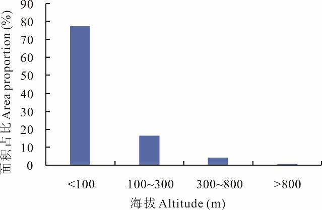
Fig.3 Distribution of grassland resources at different altitudes in 52 counties
坡向 Slope direction | 坡位Slope location | 合计 Total | ||||
|---|---|---|---|---|---|---|
| 坡脚Foot of slope | 坡下部Lower slope | 坡中部Midslope | 坡上部Upper slope | 坡顶Hilltop | ||
| 半阳坡Half sunny slope | 35 | 29 | 121 | 63 | 14 | 262 |
| 阳坡Sunny slope | 95 | 41 | 92 | 123 | 57 | 408 |
| 半阴坡 Half shady slope | 8 | 21 | 60 | 25 | 14 | 128 |
| 阴坡Shady slope | 11 | 12 | 25 | 19 | 7 | 74 |
| 合计Total | 149 | 103 | 298 | 230 | 92 | 872 |
Table 2 The direction of the slope and slope location distribution of grassland resources in 52 counties
坡向 Slope direction | 坡位Slope location | 合计 Total | ||||
|---|---|---|---|---|---|---|
| 坡脚Foot of slope | 坡下部Lower slope | 坡中部Midslope | 坡上部Upper slope | 坡顶Hilltop | ||
| 半阳坡Half sunny slope | 35 | 29 | 121 | 63 | 14 | 262 |
| 阳坡Sunny slope | 95 | 41 | 92 | 123 | 57 | 408 |
| 半阴坡 Half shady slope | 8 | 21 | 60 | 25 | 14 | 128 |
| 阴坡Shady slope | 11 | 12 | 25 | 19 | 7 | 74 |
| 合计Total | 149 | 103 | 298 | 230 | 92 | 872 |
草地等 Grassland-grade | 草地级Grassland-level | 合计 Total | |||||||
|---|---|---|---|---|---|---|---|---|---|
| 1 | 2 | 3 | 4 | 5 | 6 | 7 | 8 | ||
| Ⅰ | 10 | 3 | 2 | 1 | 0 | 3 | 0 | 0 | 19 |
| Ⅱ | 42 | 29 | 18 | 13 | 2 | 7 | 0 | 0 | 111 |
| Ⅲ | 436 | 70 | 100 | 26 | 14 | 13 | 5 | 0 | 664 |
| Ⅳ | 13 | 4 | 5 | 3 | 1 | 14 | 11 | 3 | 54 |
| Ⅴ | 2 | 1 | 2 | 1 | 0 | 3 | 2 | 13 | 24 |
| 合计Total | 503 | 107 | 127 | 44 | 17 | 40 | 18 | 16 | 872 |
Table 3 Grassland-grade and grassland-level sample plots in 52 counties
草地等 Grassland-grade | 草地级Grassland-level | 合计 Total | |||||||
|---|---|---|---|---|---|---|---|---|---|
| 1 | 2 | 3 | 4 | 5 | 6 | 7 | 8 | ||
| Ⅰ | 10 | 3 | 2 | 1 | 0 | 3 | 0 | 0 | 19 |
| Ⅱ | 42 | 29 | 18 | 13 | 2 | 7 | 0 | 0 | 111 |
| Ⅲ | 436 | 70 | 100 | 26 | 14 | 13 | 5 | 0 | 664 |
| Ⅳ | 13 | 4 | 5 | 3 | 1 | 14 | 11 | 3 | 54 |
| Ⅴ | 2 | 1 | 2 | 1 | 0 | 3 | 2 | 13 | 24 |
| 合计Total | 503 | 107 | 127 | 44 | 17 | 40 | 18 | 16 | 872 |
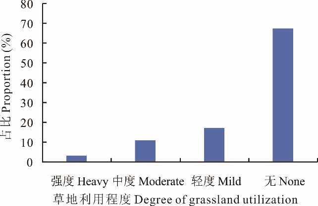
Fig. 4 Grassland utilization intensity in 52 counties

Fig. 5 Hay yield in 52 counties grassland
县 County | 计划清查样地 Planned checking sample points | 草地面积Grassland area (hm2) | 减少率 Reduction rate (%) | |
|---|---|---|---|---|
| 1983 | 2019 | |||
| 安乡Anxiang | 62 | 2691.20 | 1488.07 | 44.71 |
| 汉寿Hanshou | 64 | 6729.62 | 225.09 | 96.66 |
| 鼎城Dingcheng | 72 | 2257.68 | 17.92 | 99.21 |
| 津市Jinshi | 51 | 215.39 | 1.33 | 99.38 |
| 桃源Taoyuan | 100 | 789.42 | 64.25 | 91.86 |
| 临澧Linli | 61 | 1299.81 | 85.07 | 93.46 |
| 武陵区Wulingqu | 60 | 376.34 | 58.94 | 84.34 |
| 北湖区Beihuqu | 56 | 411.13 | 200.05 | 51.34 |
| 苏仙区Suxianqu | 59 | 524.45 | 126.90 | 75.80 |
| 衡东Hengdong | 64 | 286.37 | 120.10 | 58.06 |
| 衡南Hengnan | 87 | 313.00 | 63.63 | 79.67 |
| 衡山Hengshan | 59 | 203.30 | 42.12 | 79.28 |
| 衡阳Hengyang | 64 | 119.63 | 36.63 | 69.38 |
| 祁东Qidong | 65 | 318.38 | 26.19 | 91.77 |
| 耒阳Leiyang | 60 | 1271.40 | 408.49 | 67.87 |
| 常宁Changning | 69 | 249.38 | 121.63 | 51.23 |
| 鹤城区Hechengqu | 49 | 331.75 | 12.47 | 96.24 |
| 洪江Hongjiang | 64 | 222.47 | 2.64 | 98.81 |
| 中方Zhongfang | 53 | 215.67 | 6.08 | 97.18 |
| 冷水江Lengshuijiang | 70 | 847.54 | 386.04 | 54.45 |
| 涟源Lianyuan | 78 | 965.86 | 504.25 | 47.79 |
| 娄星Louxing | 41 | 274.53 | 3.67 | 98.66 |
| 邵东Shaodong | 84 | 721.23 | 398.08 | 44.81 |
| 邵阳Shaoyang | 61 | 654.69 | 379.85 | 41.98 |
| 新邵Xinshao | 75 | 544.81 | 107.28 | 80.31 |
| 韶山Shaoshan | 13 | 73.78 | 24.86 | 66.31 |
| 湘潭Xiangtan | 60 | 322.73 | 88.65 | 72.53 |
| 湘乡Xiangxiang | 60 | 463.24 | 121.85 | 73.70 |
| 花垣Huayuan | 60 | 520.36 | 15.67 | 96.99 |
| 桃江Taojiang | 60 | 593.78 | 167.18 | 71.85 |
| 南县Nanxian | 60 | 1902.87 | 1181.20 | 37.93 |
| 沅江Yuanjiang | 60 | 11156.60 | 4570.41 | 59.03 |
| 资阳区Ziyangqu | 19 | 153.90 | 28.00 | 81.81 |
| 赫山Heshan | 59 | 225.67 | 64.51 | 71.41 |
| 冷水滩区Lengshuitanqu | 60 | 832.05 | 406.80 | 51.11 |
| 零陵Lingling | 60 | 952.73 | 528.71 | 44.51 |
| 祁阳Qiyang | 70 | 874.72 | 440.53 | 49.64 |
| 华容Huarong | 60 | 3423.13 | 1066.24 | 68.85 |
| 君山Junshan | 47 | 4666.19 | 3531.16 | 24.32 |
| 临湘Linxiang | 59 | 352.79 | 161.36 | 54.26 |
| 汨罗Miluo | 59 | 270.91 | 32.06 | 88.17 |
| 湘阴Xiangyin | 58 | 4238.68 | 123.43 | 97.09 |
| 岳阳楼区Yueyanglouqu | 30 | 146.63 | 14.13 | 90.36 |
| 岳阳Yueyang | 60 | 8844.47 | 285.73 | 96.77 |
| 云溪区Yunxiqu | 31 | 210.40 | 46.00 | 78.14 |
| 武陵源区Wulingyuanqu | 15 | 40.13 | 2.13 | 94.68 |
| 永定区Yongdingqu | 50 | 656.44 | 5.64 | 99.14 |
| 宁乡Ningxiang | 61 | 315.14 | 114.93 | 63.53 |
| 望城Wangcheng | 57 | 138.79 | 41.98 | 69.75 |
| 长沙Changsha | 55 | 183.70 | 59.03 | 67.87 |
| 醴陵Liling | 60 | 298.59 | 86.53 | 71.02 |
| 株洲Zhuzhou | 60 | 441.14 | 63.05 | 85.71 |
Table 4 The natural grassland area in 52 counties
县 County | 计划清查样地 Planned checking sample points | 草地面积Grassland area (hm2) | 减少率 Reduction rate (%) | |
|---|---|---|---|---|
| 1983 | 2019 | |||
| 安乡Anxiang | 62 | 2691.20 | 1488.07 | 44.71 |
| 汉寿Hanshou | 64 | 6729.62 | 225.09 | 96.66 |
| 鼎城Dingcheng | 72 | 2257.68 | 17.92 | 99.21 |
| 津市Jinshi | 51 | 215.39 | 1.33 | 99.38 |
| 桃源Taoyuan | 100 | 789.42 | 64.25 | 91.86 |
| 临澧Linli | 61 | 1299.81 | 85.07 | 93.46 |
| 武陵区Wulingqu | 60 | 376.34 | 58.94 | 84.34 |
| 北湖区Beihuqu | 56 | 411.13 | 200.05 | 51.34 |
| 苏仙区Suxianqu | 59 | 524.45 | 126.90 | 75.80 |
| 衡东Hengdong | 64 | 286.37 | 120.10 | 58.06 |
| 衡南Hengnan | 87 | 313.00 | 63.63 | 79.67 |
| 衡山Hengshan | 59 | 203.30 | 42.12 | 79.28 |
| 衡阳Hengyang | 64 | 119.63 | 36.63 | 69.38 |
| 祁东Qidong | 65 | 318.38 | 26.19 | 91.77 |
| 耒阳Leiyang | 60 | 1271.40 | 408.49 | 67.87 |
| 常宁Changning | 69 | 249.38 | 121.63 | 51.23 |
| 鹤城区Hechengqu | 49 | 331.75 | 12.47 | 96.24 |
| 洪江Hongjiang | 64 | 222.47 | 2.64 | 98.81 |
| 中方Zhongfang | 53 | 215.67 | 6.08 | 97.18 |
| 冷水江Lengshuijiang | 70 | 847.54 | 386.04 | 54.45 |
| 涟源Lianyuan | 78 | 965.86 | 504.25 | 47.79 |
| 娄星Louxing | 41 | 274.53 | 3.67 | 98.66 |
| 邵东Shaodong | 84 | 721.23 | 398.08 | 44.81 |
| 邵阳Shaoyang | 61 | 654.69 | 379.85 | 41.98 |
| 新邵Xinshao | 75 | 544.81 | 107.28 | 80.31 |
| 韶山Shaoshan | 13 | 73.78 | 24.86 | 66.31 |
| 湘潭Xiangtan | 60 | 322.73 | 88.65 | 72.53 |
| 湘乡Xiangxiang | 60 | 463.24 | 121.85 | 73.70 |
| 花垣Huayuan | 60 | 520.36 | 15.67 | 96.99 |
| 桃江Taojiang | 60 | 593.78 | 167.18 | 71.85 |
| 南县Nanxian | 60 | 1902.87 | 1181.20 | 37.93 |
| 沅江Yuanjiang | 60 | 11156.60 | 4570.41 | 59.03 |
| 资阳区Ziyangqu | 19 | 153.90 | 28.00 | 81.81 |
| 赫山Heshan | 59 | 225.67 | 64.51 | 71.41 |
| 冷水滩区Lengshuitanqu | 60 | 832.05 | 406.80 | 51.11 |
| 零陵Lingling | 60 | 952.73 | 528.71 | 44.51 |
| 祁阳Qiyang | 70 | 874.72 | 440.53 | 49.64 |
| 华容Huarong | 60 | 3423.13 | 1066.24 | 68.85 |
| 君山Junshan | 47 | 4666.19 | 3531.16 | 24.32 |
| 临湘Linxiang | 59 | 352.79 | 161.36 | 54.26 |
| 汨罗Miluo | 59 | 270.91 | 32.06 | 88.17 |
| 湘阴Xiangyin | 58 | 4238.68 | 123.43 | 97.09 |
| 岳阳楼区Yueyanglouqu | 30 | 146.63 | 14.13 | 90.36 |
| 岳阳Yueyang | 60 | 8844.47 | 285.73 | 96.77 |
| 云溪区Yunxiqu | 31 | 210.40 | 46.00 | 78.14 |
| 武陵源区Wulingyuanqu | 15 | 40.13 | 2.13 | 94.68 |
| 永定区Yongdingqu | 50 | 656.44 | 5.64 | 99.14 |
| 宁乡Ningxiang | 61 | 315.14 | 114.93 | 63.53 |
| 望城Wangcheng | 57 | 138.79 | 41.98 | 69.75 |
| 长沙Changsha | 55 | 183.70 | 59.03 | 67.87 |
| 醴陵Liling | 60 | 298.59 | 86.53 | 71.02 |
| 株洲Zhuzhou | 60 | 441.14 | 63.05 | 85.71 |

Fig.6 Grassland coverage in 52 counties
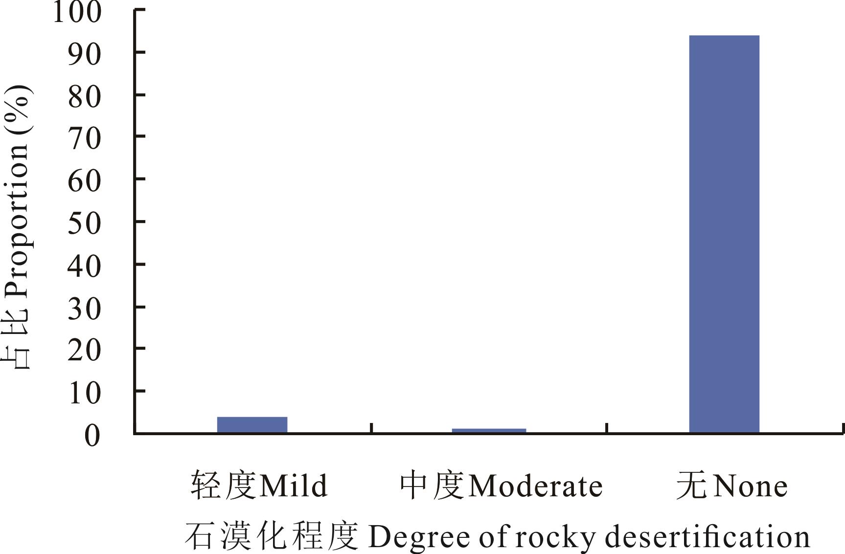
Fig.7 Grassland rocky desertification in 52 counties

Fig.8 Grassland degradation in 52 counties
| 1 | Li F Y, Yin Q W, Hu J, et al. Distribution and type characteristics of grassland resources in Chongqing. Acta Agrestia Sinica, 2020, 28(2): 474-482. |
| 李发玉, 尹权为, 胡俊, 等. 重庆市草地资源分布现状及类型特征. 草地学报, 2020, 28(2): 474-482. | |
| 2 | He Y J, Huang W, Zhong Z X, et al. Inventory report of grassland resources in Xiangtan city and suggestions on utilization and protection. Crop Research, 2022, 36(3): 280-286. |
| 何也君, 黄伟, 钟梓轩, 等. 湘潭市草地资源清查及利用保护建议. 作物研究, 2022, 36(3): 280-286. | |
| 3 | Department of Animal Husbandry and Veterinary, General Station of Animal Husbandry and Veterinary of Ministry of Agriculture of China. Rangeland resources of China. Beijing: China Science & Technology Press, 1996. |
| 中华人民共和国农业部畜牧兽医司, 全国畜牧兽医总站. 中国草地资源. 北京: 中国科学技术出版社, 1996. | |
| 4 | Zhang J X, Li K Y. Analysis of forage germplasm resources in Hunan. Journal of Sichuan Grassland, 2004(11): 39-41. |
| 张金孝, 李科云. 湖南牧草种质资源的剖析. 四川草原, 2004(11): 39-41. | |
| 5 | Yu K Z. Implement new requirements for ecological civilization construction and continuously improve grassland supervision and management capabilities and levels. China Animal Industry, 2017(14): 23-27. |
| 于康震. 落实生态文明建设新要求不断提高草原监督管理能力和水平. 中国畜牧业, 2017(14): 23-27. | |
| 6 | Shen H H, Zhu Y K, Zhao X, et al. Analysis of current grassland resources in China. Chinese Science Bulletin, 2016, 61(2): 139-154. |
| 沈海花, 朱言坤, 赵霞, 等. 中国草地资源的现状分析. 科学通报, 2016, 61(2): 139-154. | |
| 7 | Guo S Q, Ling H, Zhang P H, et al. Survey report on grassland resources in Suxian district and Beihu district of Chenzhou city. Hubei Journal of Animal and Veterinary Sciences, 2020, 41(7): 5-8. |
| 郭水强, 凌浩, 张佩华, 等. 郴州市苏仙区、北湖区草地资源调查报告. 湖北畜牧兽医, 2020, 41(7): 5-8. | |
| 8 | Zhi S L, Wang Y Y, Wang C Q, et al. Investigation and analysis on the changes of grassland resources in Beijing in the past thirty years. China Animal Industry, 2020(1): 45-48. |
| 支树立, 王有月, 王重庆, 等. 北京市草地资源三十年变化调查与分析. 中国畜牧业, 2020(1): 45-48. | |
| 9 | Liu Y Q, Liao L W, Long H L, et al. Effects of land use transitions on ecosystem services value: A case study of Hunan Province. Geographical Research, 2015, 34(4): 691-700. |
| 刘永强, 廖柳文, 龙花楼, 等. 土地利用转型的生态系统服务价值效应分析——以湖南省为例. 地理研究, 2015, 34(4): 691-700. | |
| 10 | Zhang Q. Investigation on temporal-spatial change of water environment quality and its driving forces in Hunan Province. Changsha: Hunan University, 2008. |
| 张棋. 湖南省水环境时空变化及其影响因素研究. 长沙: 湖南大学, 2008. | |
| 11 | Hunan Provincial Bureau of Statistics and National Bureau of Statistics Hunan Survey Team. 2019 national economic and social development statistical bulletin of Hunan Province. Portal of Hunan Provincial People’s Government, 2020. http://www.hunan.gov.cn/hnszf/zfsj/tjgb/202003/t20200319_11815838.html. |
| 湖南省统计局, 国家统计局湖南调查总队. 湖南省2019年国民经济和社会发展统计公报. 湖南省人民政府门户网站, 2020. http://www.hunan.gov.cn/hnszf/zfsj/tjgb/202003/t20200319_11815838.html. | |
| 12 | Zhi S L, Wang Y Y, Wang C Q, et al. Application of 3S technology in grassland resources inventory. China Animal Industry, 2019(17): 45-47. |
| 支树立, 王有月, 王重庆, 等. 3S技术在草地资源清查中的应用. 中国畜牧业, 2019(17): 45-47. | |
| 13 | Wang Z W, Xu W H, Meng F. Research on the investigation method of grassland resources based on the third land survey result. Land & Resources Herald, 2021, 18(1): 50-53. |
| 王忠武, 徐文海, 孟芳. 基于三调成果的草地资源调查方法研究. 国土资源导刊, 2021, 18(1): 50-53. | |
| 14 | Yun X J, Dong Y P, Yin X F, et al. Technical regulations for grassland resources survey, NY/T 2998-2016. Beijing: Ministry of Agriculture of the People’s Republic of China, 2016. |
| 贠旭江, 董永平, 尹晓飞, 等. NY/T 2998-2016 草地资源调查技术规程. 北京: 中华人民共和国农业部, 2016. | |
| 15 | Du S Y. Study on quality grade evaluation of natural grassland in Leiyang city. Changsha: Hunan Agricultural University, 2020. |
| 杜思言. 耒阳市天然草地质量等级评价研究. 长沙: 湖南农业大学, 2020. | |
| 16 | Yun X J, Dong Y P, Li W W, et al. NY/T 2997-2016 Grassland classification. Beijing: Ministry of Agriculture of the People’s Republic of China, 2017. |
| 贠旭江, 董永平, 李维薇, 等. NY/T 2997-2016 草地分类. 北京: 中华人民共和国农业部, 2017. | |
| 17 | Liu J W, Xing Q, Gao W, et al. NY/T 1579-2007 Technical specification for grading evaluation of natural grassland. Beijing: Ministry of Agriculture of the People’s Republic of China, 2008. |
| 刘加文, 邢旗, 高娃, 等. NY/T 1579-2007 天然草原等级评定技术规范. 北京: 中华人民共和国农业部, 2008. | |
| 18 | Yuan X J, Xing Q, Yang S P, et al. NY/ T1233-2006 Technical rules for monitoring of rangeland resources and ecology. Beijing: Ministry of Agriculture of the People’s Republic of China, 2007. |
| 员旭疆, 邢旗, 雍世鹏, 等. NY/T 1233-2006 草原资源与生态监测技术规程. 北京: 中华人民共和国农业部, 2007. | |
| 19 | Su D X, Zhang Z H, Chen Z Z, et al. GB19377-2003 Parameters for degradation,sandification and salification of rangelands. Beijing: General Administration of Quality Supervision, Inspection and Quarantine of the People’s Republic of China, 2004. |
| 苏大学, 张自和, 陈佐忠, 等. GB19377-2003 天然草地退化、沙化、盐渍化的分级指标. 北京: 中华人民共和国国家质量监督检验检疫总局, 2004. | |
| 20 | Xie B G, Cheng W M, Li X Q. Research on Hunan grassland resources and its development and utilization. Territory & Natural Resources Study, 1992(1): 38-42, 51. |
| 谢炳庚, 程伟民, 李晓青. 湖南草地资源及其开发利用研究. 国土与自然资源研究, 1992(1): 38-42, 51. | |
| 21 | Huangfu J Y, Mao F X, Lu X S. Analysis of grassland resources in southwest China. Acta Prataculturae Sinica, 2012, 21(1): 75-82. |
| 皇甫江云, 毛凤显, 卢欣石. 中国西南地区的草地资源分析. 草业学报, 2012, 21(1): 75-82. | |
| 22 | Gao C S. Strategies for speeding up the construction and utilization of grassy hills and slopes in the south of China//Proceedings of the 2009 China Grassland Development Forum, DOI: ConferenceArticle/5aa0013ac095d722206205ae. |
| 高春石. 加快南方草山草坡建设利用对策研究//2009中国草原发展论坛论文集. DOI: ConferenceArticle/5aa0013ac095d 722206205ae. | |
| 23 | Jiang Y H. Grassland resources and their development and utilization of Yongzhou city in Hunan. Journal of Hunan University of Science and Engineering, 2005(8): 73-74. |
| 蒋艳华. 湖南永州地区草地资源及其开发利用. 湖南科技学院学报, 2005(8): 73-74. | |
| 24 | Wang B S. Discussion on the development mode of cattle and sheep herbivorous animal husbandry in comprehensive control of rocky desertification. The Chinese Livestock and Poultry Breeding, 2021, 17(3): 31-32. |
| 王柏松. 石漠化综合治理中牛羊草食畜牧业发展模式的探讨. 中国畜禽种业, 2021, 17(3): 31-32. |
| [1] | Song-ke MA, Ke HUO, Dong-xia ZHANG, Jing ZHANG, Jun-hao ZHANG, Xue-ru CHAI, He-zheng WANG. Effects of maize straw return combined with nitrogen on soil enzyme activity and nitrogen fertilizer use efficiency in western dryland wheat fields of Henan Province [J]. Acta Prataculturae Sinica, 2023, 32(6): 120-133. |
| [2] | Ya-xian ZHANG, Jiang-wen FAN, Sui-zi WANG, Hai-yan ZHANG. Grassland investigation, monitoring and evaluation: international experience and insight [J]. Acta Prataculturae Sinica, 2023, 32(6): 203-213. |
| [3] | Xiao-xia AN, Ying-ying ZHANG, Chun-hui MA, Man LI, Qian-bing ZHANG. Effects of phosphorus application and inoculation with arbuscular mycorrhizal fungi on alfalfa yield and phosphorus use efficiency [J]. Acta Prataculturae Sinica, 2023, 32(6): 71-84. |
| [4] | Ji FENG, Zhi-kuo LIU, Hai-yan LI, Yun-fei YANG, Jian GUO. Effects of enclosure and long-term mowing on vegetative reproduction characteristics of Leymus chinensis and Arundinella hirta populations in the Songnen Grassland, China [J]. Acta Prataculturae Sinica, 2023, 32(5): 50-60. |
| [5] | Tong-yao LI, Qing-ping ZHOU, You-jun CHEN, Yuan ZHAN, Hui WANG. Effects of nitrogen application rate on seed yield and nitrogen use efficiency of Elymus [J]. Acta Prataculturae Sinica, 2023, 32(3): 80-90. |
| [6] | Feng HAN, Zhi-tao ZHANG, Xin ZHANG, Jian-hao WANG, Hao WANG. Legal process and governance of public rangelands: Experiences and implications from America [J]. Acta Prataculturae Sinica, 2022, 31(9): 220-232. |
| [7] | Duo ZHANG, Lan-tao LI, Di LIN, Long-hui ZHENG, Sai-nan GENG, Wen-xuan SHI, Kai SHENG, Yu-hong MIAO, Yi-lun WANG. Effects of P fertilization rate on tuber yield, quality, plant physiological attributes and P use efficiency of Helianthus tuberosus [J]. Acta Prataculturae Sinica, 2022, 31(6): 139-149. |
| [8] | Ying LI, Jing WU, Chun-bin LI, Ge-xia QIN. Temporal and spatial variation in grassland ground surface soil heat flux on the Qinghai-Tibetan Plateau from 2003 to 2018 [J]. Acta Prataculturae Sinica, 2022, 31(11): 1-14. |
| [9] | Gang FU, Jun-hao WANG, Shao-wei LI, Ping HE. Responses of forage nutrient quality to grazing in the alpine grassland of Northern Tibet [J]. Acta Prataculturae Sinica, 2021, 30(9): 38-50. |
| [10] | Chao ZHANG, Rui-rui YAN, Qing-wei LIANG, Ri-su NA, Tong LI, Xiu-fang YANG, Yu-hai BAO, Xiao-ping XIN. Study on soil physical and chemical properties and carbon and nitrogen sequestration of grassland under different utilization modes [J]. Acta Prataculturae Sinica, 2021, 30(4): 90-98. |
| [11] | Guang-yi LV, Xue-bao XU, Cui-ping GAO, Zhi-hui YU, Xin-ya WANG, Cheng-jie WANG. Effects of grazing on total nitrogen and stable nitrogen isotopes of plants and soil in different types of grasslands in Inner Mongolia [J]. Acta Prataculturae Sinica, 2021, 30(3): 208-214. |
| [12] | Wen ZHAO, Ya-li YIN, Shi-xiong LI, Yan LIU, Jing-jing LIU, Yi-ling DONG, Shi-feng SU, Ling-he JI. The characteristics of bacterial communities in different vegetation types in the Qilian Mountains [J]. Acta Prataculturae Sinica, 2021, 30(12): 161-171. |
| [13] | Fan ZHANG, Qian YANG. Effects of co-utilization of Chinese milk vetch and rice straw on the potassium cycle and potassium balance in a paddy soil [J]. Acta Prataculturae Sinica, 2021, 30(1): 72-80. |
| [14] | LÜ Han-qiang, YU Ai-zhong, WANG Yu-long, SU Xiang-xiang, LÜ Yi-tong, CHAI Qiang. Effect of green manure retention practices on nitrogen absorption and utilization by maize crops in the arid oasis irrigation area [J]. Acta Prataculturae Sinica, 2020, 29(8): 93-103. |
| [15] | SUN Qi-zhong, LIU Qian, TAO Ya, LI Feng, XU Li-jun. Textual research on the cultivation and utilization of alfalfa in the Qing Dynasty [J]. Acta Prataculturae Sinica, 2019, 28(4): 168-191. |
| Viewed | ||||||
|
Full text |
|
|||||
|
Abstract |
|
|||||