

ISSN 1004-5759 CN 62-1105/S
草业学报 ›› 2023, Vol. 32 ›› Issue (1): 1-15.DOI: 10.11686/cyxb2021298
• 研究论文 •
修炀景( ), 侯蒙京, 田骄阳, 梁天刚, 冯琦胜()
收稿日期:2021-08-03
修回日期:2021-12-20
出版日期:2023-01-20
发布日期:2022-11-07
通讯作者:
冯琦胜
作者简介:E-mail: fengqsh@lzu.edu.cn基金资助:
Yang-jing XIU(), Meng-jing HOU, Jiao-yang TIAN, Tian-gang LIANG, Qi-sheng FENG()
Received:2021-08-03
Revised:2021-12-20
Online:2023-01-20
Published:2022-11-07
Contact:
Qi-sheng FENG
摘要:
甘肃省景观类型丰富多样,在中国西部地区的生态安全中起关键性作用,也为当地发展提供着重要的物质基础和生态服务。由于气候变化和人类不合理活动的影响,甘肃省部分地区生态环境的安全与稳定遭到严峻挑战。本研究基于欧洲航空局全球土地利用/覆盖数据(CCI-LC),利用动态度、转移矩阵方法分析了2005-2019年甘肃省土地利用/覆盖变化特征;通过构建景观生态风险指数并运用空间自相关分析法分析了景观生态风险的空间分布特征。结果显示:1)2005-2019年间,裸地面积减少最多,变化率1.88%,耕地次之,变化率2.31%;草地面积增加最多,变化率1.83%,建设用地次之,变化率191.08%。2)所有土地利用/覆盖类型中,建设用地的动态度最高且在整个研究时期内变化速率都保持在较高水平,综合动态度最大的时期为2010-2019年。3)土地利用/覆盖转移矩阵主要表现为耕地、林地、草地、裸地之间的转入与转出以及其他土地类型向建设用地的转入。4)2019年整体的生态风险值较2005年明显上升。其中低风险区和较低风险区面积最多,转化最频繁;中等风险区、较高风险区和高风险区面积虽然较少,但都存在不同程度的增长。5)2005-2019年间,Moran’s I维持在较高水平,景观生态风险的空间分布呈正相关,聚集效应强。本研究旨在为西北地区土地利用规划和生态风险管控提供科学依据。
修炀景, 侯蒙京, 田骄阳, 梁天刚, 冯琦胜. 基于土地利用/覆盖的甘肃省景观生态风险时空变化特征[J]. 草业学报, 2023, 32(1): 1-15.
Yang-jing XIU, Meng-jing HOU, Jiao-yang TIAN, Tian-gang LIANG, Qi-sheng FENG. Characteristics of temporal and spatial variation in landscape ecological risk in Gansu Province based on land use and cover[J]. Acta Prataculturae Sinica, 2023, 32(1): 1-15.
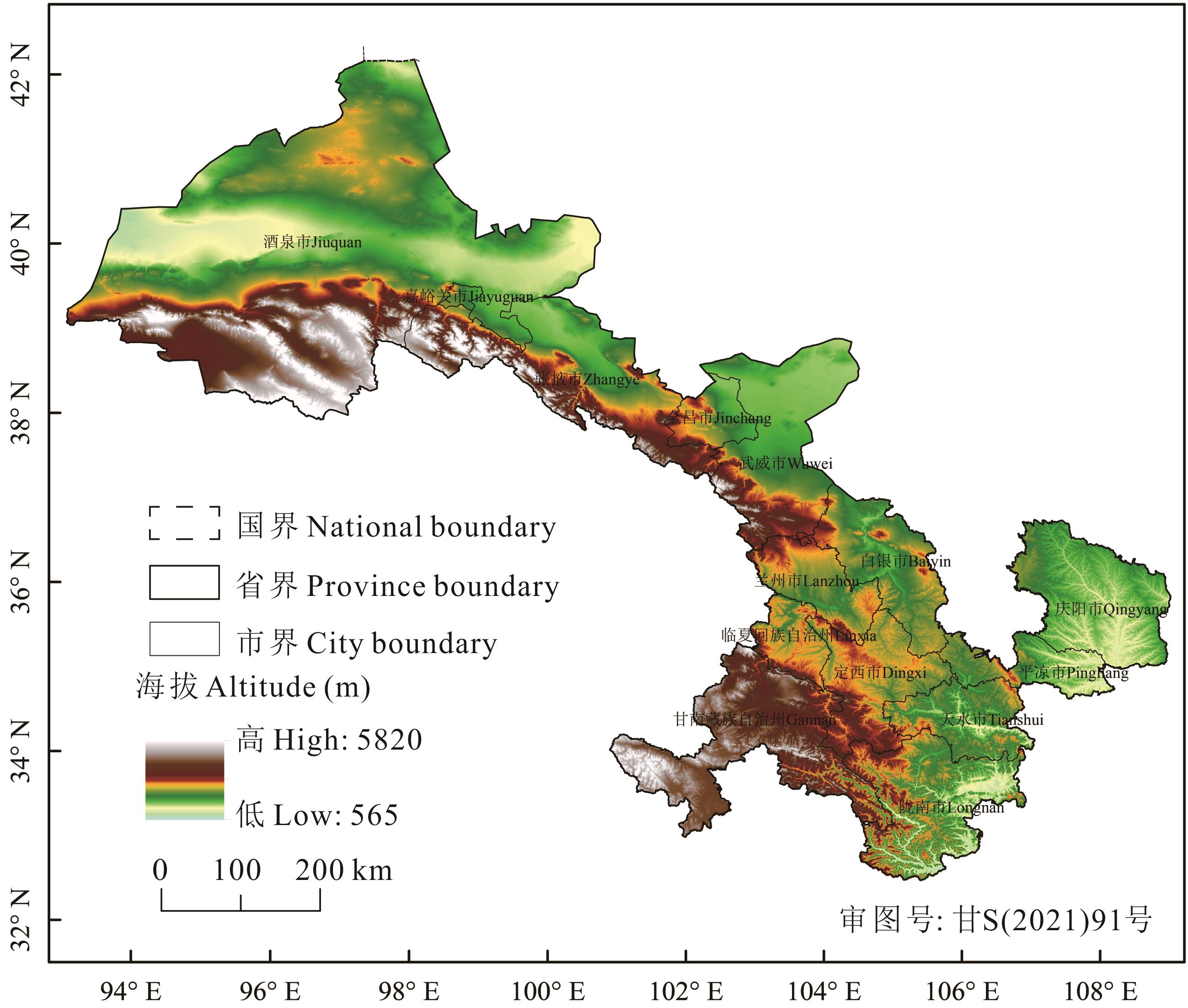
图1 研究区位置
Fig.1 Location of study area
| 新土地利用/覆盖类型New types of land use/cover | 原土地利用/覆盖类型编号Original code of land use/cover |
|---|---|
| 耕地Cultivated land | 10,20,30 |
| 林地Woodland | 12,40,50,60,61,62,70,71,72,80,81,82,90,100 |
| 草地Grassland | 11,110,130,150,153 |
| 灌丛Shrubbery | 120,121,122,152 |
| 湿地Wetland | 160,170,180 |
| 水体Water body | 210 |
| 建设用地Built-up land | 190 |
| 裸地Naked land | 200,201,202 |
| 常年冰雪Permanent ice and snow | 220 |
表1 重分类原则
Table 1 Reclassification principle
| 新土地利用/覆盖类型New types of land use/cover | 原土地利用/覆盖类型编号Original code of land use/cover |
|---|---|
| 耕地Cultivated land | 10,20,30 |
| 林地Woodland | 12,40,50,60,61,62,70,71,72,80,81,82,90,100 |
| 草地Grassland | 11,110,130,150,153 |
| 灌丛Shrubbery | 120,121,122,152 |
| 湿地Wetland | 160,170,180 |
| 水体Water body | 210 |
| 建设用地Built-up land | 190 |
| 裸地Naked land | 200,201,202 |
| 常年冰雪Permanent ice and snow | 220 |
土地利用/覆盖类型 Land use/cover types | 2005 | 2010 | 2015 | 2019 | ||||
|---|---|---|---|---|---|---|---|---|
面积 Area (km2) | 占比 Proportion (%) | 面积 Area (km2) | 占比 Proportion (%) | 面积 Area (km2) | 占比 Proportion (%) | 面积 Area (km2) | 占比 Proportion (%) | |
| 耕地Cultivated land | 64964.07 | 12.760 | 65220.57 | 12.810 | 64880.37 | 12.743 | 63460.80 | 12.465 |
| 林地Woodland | 55452.24 | 10.892 | 55162.62 | 10.835 | 54878.94 | 10.779 | 54712.53 | 10.746 |
| 草地Grassland | 223086.15 | 43.817 | 223763.94 | 43.950 | 225527.49 | 44.297 | 227158.02 | 44.617 |
| 灌丛Shrubbery | 506.52 | 0.099 | 521.37 | 0.102 | 518.67 | 0.102 | 518.76 | 0.102 |
| 湿地Wetland | 643.68 | 0.126 | 643.59 | 0.126 | 643.86 | 0.126 | 643.77 | 0.126 |
| 水体Water body | 477.99 | 0.094 | 480.51 | 0.094 | 490.86 | 0.096 | 510.30 | 0.100 |
| 建设用地Built-up land | 618.39 | 0.121 | 901.44 | 0.177 | 1282.86 | 0.252 | 1800.00 | 0.354 |
| 裸地Naked land | 162165.96 | 31.852 | 161220.96 | 31.666 | 159691.95 | 31.366 | 159110.82 | 31.251 |
| 常年冰雪Permanent ice and snow | 1210.10 | 0.238 | 1206.18 | 0.237 | 1206.18 | 0.237 | 1206.18 | 0.237 |
表2 土地利用/覆盖类型面积
Table 2 Area of each land use/cover type
土地利用/覆盖类型 Land use/cover types | 2005 | 2010 | 2015 | 2019 | ||||
|---|---|---|---|---|---|---|---|---|
面积 Area (km2) | 占比 Proportion (%) | 面积 Area (km2) | 占比 Proportion (%) | 面积 Area (km2) | 占比 Proportion (%) | 面积 Area (km2) | 占比 Proportion (%) | |
| 耕地Cultivated land | 64964.07 | 12.760 | 65220.57 | 12.810 | 64880.37 | 12.743 | 63460.80 | 12.465 |
| 林地Woodland | 55452.24 | 10.892 | 55162.62 | 10.835 | 54878.94 | 10.779 | 54712.53 | 10.746 |
| 草地Grassland | 223086.15 | 43.817 | 223763.94 | 43.950 | 225527.49 | 44.297 | 227158.02 | 44.617 |
| 灌丛Shrubbery | 506.52 | 0.099 | 521.37 | 0.102 | 518.67 | 0.102 | 518.76 | 0.102 |
| 湿地Wetland | 643.68 | 0.126 | 643.59 | 0.126 | 643.86 | 0.126 | 643.77 | 0.126 |
| 水体Water body | 477.99 | 0.094 | 480.51 | 0.094 | 490.86 | 0.096 | 510.30 | 0.100 |
| 建设用地Built-up land | 618.39 | 0.121 | 901.44 | 0.177 | 1282.86 | 0.252 | 1800.00 | 0.354 |
| 裸地Naked land | 162165.96 | 31.852 | 161220.96 | 31.666 | 159691.95 | 31.366 | 159110.82 | 31.251 |
| 常年冰雪Permanent ice and snow | 1210.10 | 0.238 | 1206.18 | 0.237 | 1206.18 | 0.237 | 1206.18 | 0.237 |

图2 甘肃省土地利用/覆盖类型分布
Fig.2 Distribution of land use/cover types in Gansu Province
土地利用/覆盖类型 Land use/cover types | 2005-2010 | 2010-2015 | 2015-2019 |
|---|---|---|---|
| 综合动态度 Synthetic | 0.05 | 0.09 | 0.09 |
| 耕地Cultivated land | 0.08 | -0.10 | -0.44 |
| 林地Woodland | -0.10 | -0.10 | -0.06 |
| 草地Grassland | 0.06 | 0.16 | 0.14 |
| 灌丛Shrubbery | 0.59 | -0.10 | 0.00 |
| 湿地Wetland | 0.00 | 0.01 | 0.00 |
| 水体Water body | 0.11 | 0.43 | 0.79 |
| 建设用地Built-up land | 9.15 | 8.46 | 8.06 |
| 裸地Naked land | -0.12 | -0.19 | -0.07 |
| 常年冰雪Permanent ice and snow | -0.07 | 0.00 | 0.00 |
表3 土地利用/覆盖动态度
Table 3 Dynamic degree of land use/cover (%)
土地利用/覆盖类型 Land use/cover types | 2005-2010 | 2010-2015 | 2015-2019 |
|---|---|---|---|
| 综合动态度 Synthetic | 0.05 | 0.09 | 0.09 |
| 耕地Cultivated land | 0.08 | -0.10 | -0.44 |
| 林地Woodland | -0.10 | -0.10 | -0.06 |
| 草地Grassland | 0.06 | 0.16 | 0.14 |
| 灌丛Shrubbery | 0.59 | -0.10 | 0.00 |
| 湿地Wetland | 0.00 | 0.01 | 0.00 |
| 水体Water body | 0.11 | 0.43 | 0.79 |
| 建设用地Built-up land | 9.15 | 8.46 | 8.06 |
| 裸地Naked land | -0.12 | -0.19 | -0.07 |
| 常年冰雪Permanent ice and snow | -0.07 | 0.00 | 0.00 |
转移类型 Transfer type | 2005-2010 | 2010-2015 | 2015-2019 | |||
|---|---|---|---|---|---|---|
转换面积 Transfer area (km2) | 转换速率 Transfer rate (km2·a-1) | 转换面积 Transfer area (km2) | 转换速率 Transfer rate (km2·a-1) | 转换面积 Transfer area (km2) | 转换速率 Transfer rate (km2·a-1) | |
| 12 | - | - | 28.17 | 5.63 | 272.25 | 54.45 |
| 13 | 87.48 | 17.50 | 233.91 | 46.78 | 1197.54 | 239.51 |
| 14 | 1.53 | 0.31 | - | - | - | - |
| 17 | 65.43 | 13.09 | 85.95 | 17.20 | 107.46 | 21.49 |
| 21 | 5.13 | 1.03 | 3.42 | 0.68 | 2.61 | 0.52 |
| 23 | 292.23 | 58.45 | 293.31 | 58.66 | 542.16 | 108.43 |
| 27 | 16.83 | 3.37 | 18.18 | 3.64 | 12.87 | 2.57 |
| 31 | 333.81 | 66.76 | 39.60 | 7.92 | 242.64 | 48.53 |
| 32 | 50.13 | 10.03 | 37.08 | 7.42 | 145.35 | 29.07 |
| 34 | 12.42 | 2.48 | - | - | - | - |
| 36 | 4.23 | 0.85 | 9.18 | 1.84 | 13.05 | 2.61 |
| 37 | 160.65 | 32.13 | 224.01 | 44.80 | 317.34 | 63.47 |
| 38 | 361.89 | 72.38 | 238.59 | 47.72 | 1030.50 | 206.10 |
| 42 | - | - | 2.16 | 0.43 | - | - |
| 47 | - | - | - | - | 1.71 | 0.34 |
| 67 | 1.44 | 0.29 | 1.08 | 0.22 | - | - |
| 81 | 30.15 | 6.03 | 3.06 | 0.61 | 19.17 | 3.83 |
| 82 | 1.26 | 0.25 | - | - | - | - |
| 83 | 1148.94 | 229.79 | 1558.98 | 311.80 | 1476.09 | 295.22 |
| 84 | - | - | - | - | 1.26 | 0.25 |
| 86 | - | - | - | - | 3.24 | 0.65 |
| 87 | 11.16 | 2.23 | 15.93 | 3.19 | 28.44 | 5.69 |
| 其他Others | 2.16 | 0.43 | 1.44 | 0.29 | 3.15 | 0.63 |
表4 2005-2019年土地利用/覆盖转移矩阵
Table 4 Land use/cover transfer matrix from 2005 to 2019
转移类型 Transfer type | 2005-2010 | 2010-2015 | 2015-2019 | |||
|---|---|---|---|---|---|---|
转换面积 Transfer area (km2) | 转换速率 Transfer rate (km2·a-1) | 转换面积 Transfer area (km2) | 转换速率 Transfer rate (km2·a-1) | 转换面积 Transfer area (km2) | 转换速率 Transfer rate (km2·a-1) | |
| 12 | - | - | 28.17 | 5.63 | 272.25 | 54.45 |
| 13 | 87.48 | 17.50 | 233.91 | 46.78 | 1197.54 | 239.51 |
| 14 | 1.53 | 0.31 | - | - | - | - |
| 17 | 65.43 | 13.09 | 85.95 | 17.20 | 107.46 | 21.49 |
| 21 | 5.13 | 1.03 | 3.42 | 0.68 | 2.61 | 0.52 |
| 23 | 292.23 | 58.45 | 293.31 | 58.66 | 542.16 | 108.43 |
| 27 | 16.83 | 3.37 | 18.18 | 3.64 | 12.87 | 2.57 |
| 31 | 333.81 | 66.76 | 39.60 | 7.92 | 242.64 | 48.53 |
| 32 | 50.13 | 10.03 | 37.08 | 7.42 | 145.35 | 29.07 |
| 34 | 12.42 | 2.48 | - | - | - | - |
| 36 | 4.23 | 0.85 | 9.18 | 1.84 | 13.05 | 2.61 |
| 37 | 160.65 | 32.13 | 224.01 | 44.80 | 317.34 | 63.47 |
| 38 | 361.89 | 72.38 | 238.59 | 47.72 | 1030.50 | 206.10 |
| 42 | - | - | 2.16 | 0.43 | - | - |
| 47 | - | - | - | - | 1.71 | 0.34 |
| 67 | 1.44 | 0.29 | 1.08 | 0.22 | - | - |
| 81 | 30.15 | 6.03 | 3.06 | 0.61 | 19.17 | 3.83 |
| 82 | 1.26 | 0.25 | - | - | - | - |
| 83 | 1148.94 | 229.79 | 1558.98 | 311.80 | 1476.09 | 295.22 |
| 84 | - | - | - | - | 1.26 | 0.25 |
| 86 | - | - | - | - | 3.24 | 0.65 |
| 87 | 11.16 | 2.23 | 15.93 | 3.19 | 28.44 | 5.69 |
| 其他Others | 2.16 | 0.43 | 1.44 | 0.29 | 3.15 | 0.63 |
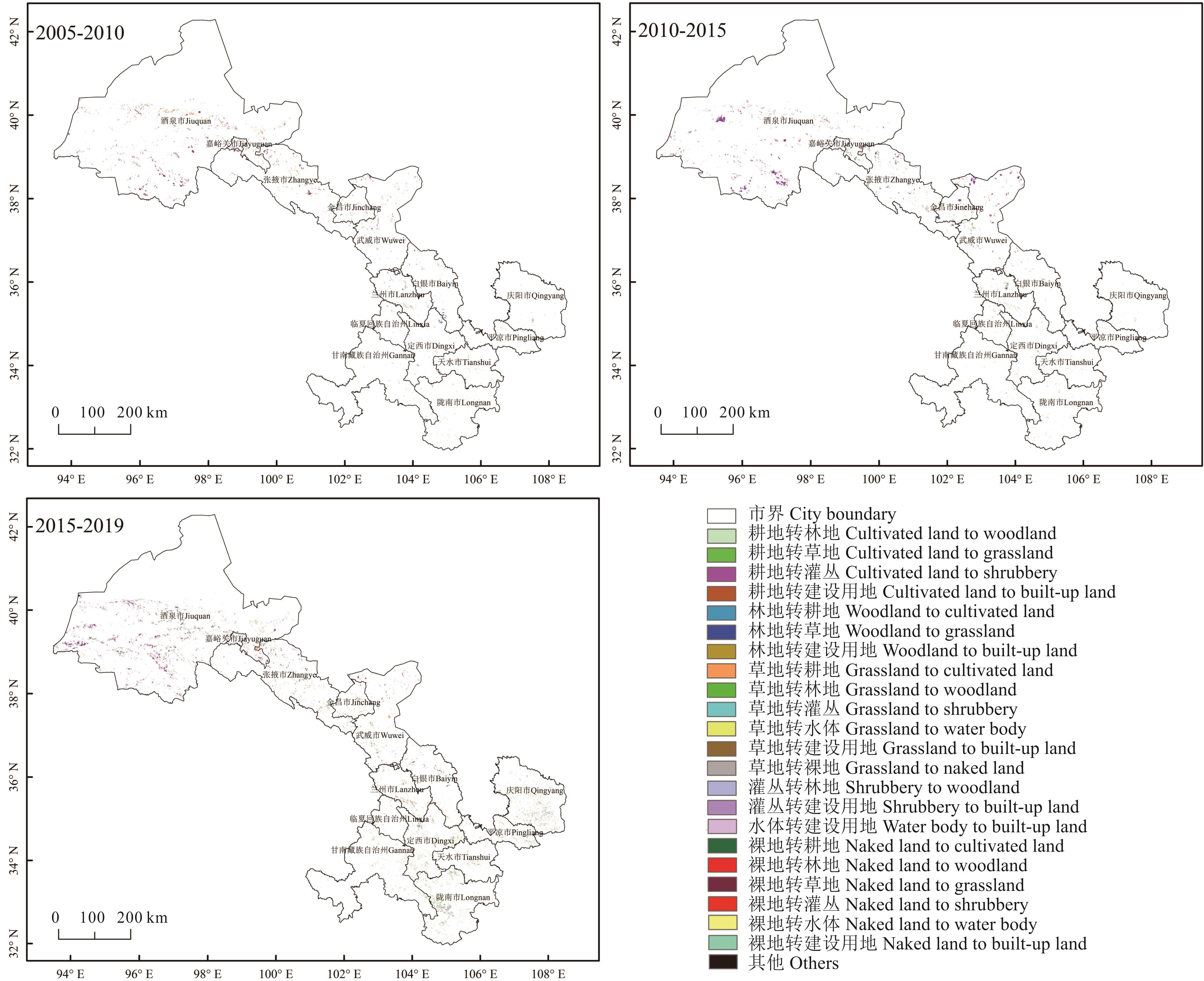
图3 2005-2019年甘肃省土地覆盖类型转移
Fig.3 Transfer of land cover types in Gansu Province from 2005 to 2019

图4 甘肃省景观生态风险空间分布
Fig.4 Spatial distribution of landscape ecological risk in Gansu Province
年份 Year | 低风险区 Lowest risk zone | 较低风险区 Lower risk zone | 中等风险区 Moderate risk zone | 较高风险区 Higher risk zone | 高风险区 Highest risk zone |
|---|---|---|---|---|---|
| 2005 | 61.24 | 9.29 | 8.16 | 8.02 | 13.29 |
| 2010 | 61.37 | 9.21 | 8.18 | 8.16 | 13.08 |
| 2015 | 32.31 | 33.36 | 12.24 | 9.11 | 12.98 |
| 2019 | 32.04 | 33.23 | 11.89 | 8.99 | 13.85 |
表5 各生态风险等级面积所占百分比
Table 5 Percentage of area of each ecological risk level (%)
年份 Year | 低风险区 Lowest risk zone | 较低风险区 Lower risk zone | 中等风险区 Moderate risk zone | 较高风险区 Higher risk zone | 高风险区 Highest risk zone |
|---|---|---|---|---|---|
| 2005 | 61.24 | 9.29 | 8.16 | 8.02 | 13.29 |
| 2010 | 61.37 | 9.21 | 8.18 | 8.16 | 13.08 |
| 2015 | 32.31 | 33.36 | 12.24 | 9.11 | 12.98 |
| 2019 | 32.04 | 33.23 | 11.89 | 8.99 | 13.85 |
| 年份Year | 莫兰指数Moran’s I | P值P value |
|---|---|---|
| 2005 | 0.8255 | 0.00 |
| 2010 | 0.8241 | 0.00 |
| 2015 | 0.8076 | 0.00 |
| 2019 | 0.8076 | 0.00 |
表6 各时期莫兰指数和P值
Table 6 Moran’s I and P value of each period
| 年份Year | 莫兰指数Moran’s I | P值P value |
|---|---|---|
| 2005 | 0.8255 | 0.00 |
| 2010 | 0.8241 | 0.00 |
| 2015 | 0.8076 | 0.00 |
| 2019 | 0.8076 | 0.00 |
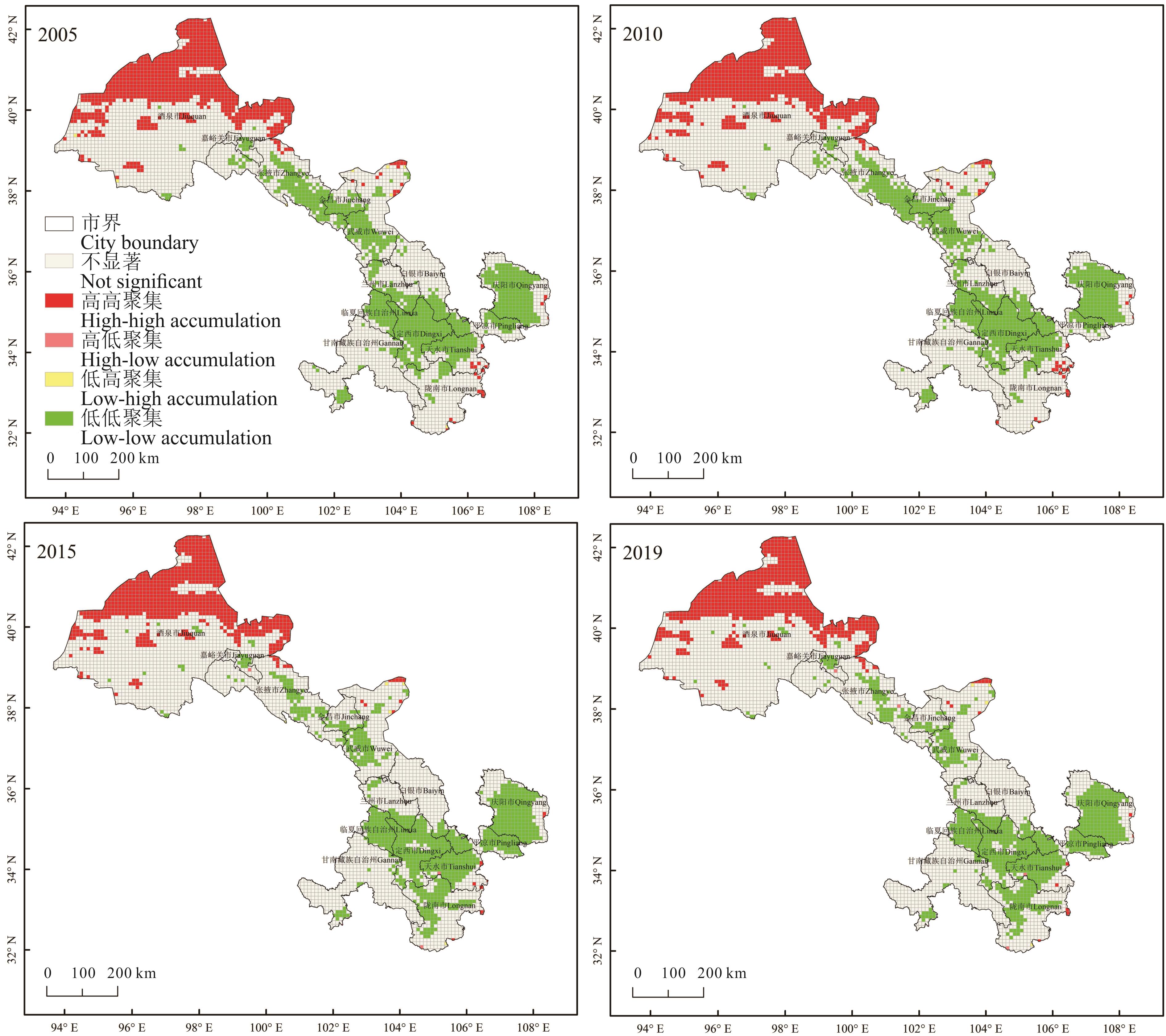
图5 甘肃省景观生态风险空间局部自相关集聚
Fig.5 Local autocorrelation clustering of landscape ecological risk space in Gansu Province
| 1 | Zhao Y, Luo Z J, Li Y T, et al. Study of the spatial-temporal variation of landscape ecological risk in the upper reaches of the Ganjiang River Basin based on the “production-living-ecological space”. Acta Ecologica Sinica, 2019, 39(13): 4676-4686. |
| 赵越, 罗志军, 李雅婷, 等. 赣江上游流域景观生态风险的时空分异——从生产-生活-生态空间的视角. 生态学报, 2019, 39(13): 4676-4686. | |
| 2 | Ma X L, Hou Q F. Spatial difference evaluation of land ecological safety in Gansu Province. Research on Land and Natural Resources, 2020, 189(6): 39-43. |
| 马小林, 侯庆丰. 甘肃省土地生态安全空间差异评价. 国土与自然资源研究, 2020, 189(6): 39-43. | |
| 3 | Wan B, Song J X, Zhang D Y. Spatial difference analysis of land use dynamic change in the Loess Plateau. Resource Conservation and Environmental Protection, 2018, 199(6): 29-30. |
| 万冰, 宋俊学, 张登越. 黄土高原地区土地利用动态变化的空间差异分析. 资源节约与环保, 2018, 199(6): 29-30. | |
| 4 | Deng Z T, Liu Z Z. Environmental problems and countermeasures in Gansu. Development, 1998(9): 45-48. |
| 邓志涛, 刘占忠. 甘肃的环境问题及其对策. 发展, 1998(9): 45-48. | |
| 5 | Zhao X J, Wang J, Su J D, et al. Assessment of habitat quality and degradation degree based on InVEST model and Moran index in Gansu Province. Transactions of the Chinese Society of Agricultural Engineering, 2020, 36(18): 301-308. |
| 赵晓冏, 王建, 苏军德, 等. 基于InVEST模型和莫兰指数的甘肃省生境质量与退化度评估. 农业工程学报, 2020, 36(18): 301-308. | |
| 6 | Xu J, Wu X Y, Li W L. Ecological conservation redline zoning at the regional scale: A case study of northwest China. Pratacultural Science, 2021, 38(7): 1218-1230. |
| 许静, 吴欣悦, 李文龙. 区域尺度生态保护红线分区研究: 以我国西北地区为例. 草业科学, 2021, 38(7): 1218-1230. | |
| 7 | Peng J, Dang W X, Liu Y X, et al. Review on landscape ecological risk assessment. Acta Geographica Sinica, 2015(4): 664-677. |
| 彭建, 党威雄, 刘焱序, 等. 景观生态风险评价研究进展与展望. 地理学报, 2015(4): 664-677. | |
| 8 | Feng J, Huang X Y. Roles of remote sensing technology on monitoring resources and environment and its trends. Remote Sensing Technology and Application, 1999(4): 59-70. |
| 冯筠, 黄新宇. 遥感技术在资源环境监测中的作用及发展趋势. 遥感技术与应用, 1999(4): 59-70. | |
| 9 | Hou R, Li H B, Gao Y L. Ecological risk assessment of land use in Jiangxia District of Wuhan based on landscape pattern. Research on Soil and Water Conservation, 2021, 28(1): 327-334, 407. |
| 侯蕊, 李红波, 高艳丽. 基于景观格局的武汉市江夏区土地利用生态风险评价. 水土保持研究, 2021, 28(1): 327-334, 407. | |
| 10 | Xiong Y, Wang M, Yuan H P, et al. Landscape ecological risk assessment and its spatio-temporal evolution in Dongting Lake area. Journal of Ecological Environment, 2020, 29(7): 12-21. |
| 熊鹰, 汪敏, 袁海平, 等. 洞庭湖区景观生态风险评价及其时空演化. 生态环境学报, 2020, 29(7): 12-21. | |
| 11 | Chen X Y, Xie G Z, Zhang J P. Landscape ecological risk assessment of land use changes in the coastal area of Haikou City in the past 30 years. Acta Ecologica Sinica, 2021, 41(3): 975-986. |
| 陈心怡, 谢跟踪, 张金萍. 海口市海岸带近30年土地利用变化的景观生态风险评价. 生态学报, 2021, 41(3): 975-986. | |
| 12 | Pan J H, Li L. Optimization of ecological security pattern in Gansu section of the Yellow River Basin using OWA and circuit model. Transactions of the Chinese Society of Agricultural Engineering, 2021, 37(3): 259-268. |
| 潘竟虎, 李磊. 利用OWA和电路模型优化黄河流域甘肃段生态安全格局. 农业工程学报, 2021, 37(3): 259-268. | |
| 13 | Li Y C, Ge J, Hou M J, et al. A study of the spatiotemporal dynamic of land cover types and the driving forces of grassland area change in Gannan Prefecture and Northwest Sichuan based on CCI-LC data. Acta Prataculturae Sinica, 2020, 29(3): 1-15. |
| 李元春, 葛静, 侯蒙京, 等. 基于CCI-LC数据的甘南和川西北地区土地覆盖类型时空动态分布及草地面积变化驱动力研究. 草业学报, 2020, 29(3): 1-15. | |
| 14 | Yang Y K, Xiao P F, Feng X Z, et al. Accuracy assessment of seven global land cover datasets over China. ISPRS Journal of Photogrammetry and Remote Sensing, 2017(125): 156-173. |
| 15 | Gu C L. Study on land use/cover change mechanism in Beijing. Journal of Natural Resources,1999(4): 307-312. |
| 顾朝林.北京土地利用/覆盖变化机制研究. 自然资源学报, 1999(4): 307-312. | |
| 16 | Gao X, Liu Z W, Li C X. Land use function transformation in the Xiong’an New Area based on ecological-production-living spaces and associated eco-environment effects. Acta Ecologica Sinica, 2020, 40(20): 7113-7122. |
| 高星, 刘泽伟, 李晨曦. 基于“三生空间”的雄安新区土地利用功能转型与生态环境效应研究. 生态学报, 2020, 40(20): 7113-7122. | |
| 17 | Lei J R, Chen Z Z, Chen X H, et al. Spatio-temporal changes of land use and ecosystem services value in Hainan Island from 1980 to 2018. Acta Ecologica Sinica, 2020(14): 4760-4773. |
| 雷金睿, 陈宗铸, 陈小花, 等. 1980-2018年海南岛土地利用与生态系统服务价值时空变化. 生态学报, 2020(14): 4760-4773. | |
| 18 | Yuan Z Y. Analysis of wetland landscape pattern evolution in Haikou City based on ArcGIS and Fragstats. Anhui Agricultural Science Bulletin, 2021, 27(6): 129-133. |
| 袁之煜. 基于ArcGIS与Fragstats的海口市湿地景观格局演变分析. 安徽农学通报, 2021, 27(6): 129-133. | |
| 19 | Kang Z W, Zhang Z Y, Wei H, et al. Landscape ecological risk assessment in Manas River Basin based on land use change. Acta Ecologica Sinica, 2020, 40(18): 6472-6485. |
| 康紫薇, 张正勇, 位宏, 等. 基于土地利用变化的玛纳斯河流域景观生态风险评价. 生态学报, 2020, 40(18): 6472-6485. | |
| 20 | Di X H, Su Y H, Ming H, et al. Temporal and spatial variations of landscape disturbance degree of land use in Jiangjin District, Chongqing City. Journal of Northwest Forestry University, 2021, 36(1): 187-195. |
| 邸晓慧, 苏英慧, 明弘, 等. 重庆市江津区土地利用景观干扰度时空变化. 西北林学院学报, 2021, 36(1): 187-195. | |
| 21 | Wang J, Bai W Q, Tian G H. Spatiotemporal characteristics of landscape ecological risks on the Tibetan Plateau. Resources Science, 2020, 42(9): 1739-1749. |
| 王洁, 摆万奇, 田国行. 青藏高原景观生态风险的时空特征. 资源科学, 2020, 42(9): 1739-1749. | |
| 22 | Xue D D, She G H, Wen X R, et al. Scale effect of landscape pattern of Nanjing Zhongshan Scenic Spot based on statistic analysis. Journal of Southwest Forestry University, 2012, 32(1): 30-35, 111. |
| 薛冬冬, 佘光辉, 温小荣, 等. 基于地统计分析的南京钟山风景区景观格局尺度效应分析. 西南林业大学学报, 2012, 32(1): 30-35, 111. | |
| 23 | Chen Y G. Reconstructing the mathematical process of spatial autocorrelation based on Moran’s statistics. Geographical Research, 2009, 28(6): 1449-1463. |
| 陈彦光. 基于Moran统计量的空间自相关理论发展和方法改进. 地理研究, 2009, 28(6): 1449-1463. | |
| 24 | Wang J, Cui B S, Yao H R, et al. The temporal and spatial characteristics of landscape ecological security at Lancang River Watershed of longitudinal range gorge region in Southwest China. Acta Ecologica Sinica, 2008(4): 1681-1690. |
| 王娟, 崔保山, 姚华荣, 等. 纵向岭谷区澜沧江流域景观生态安全时空分异特征. 生态学报, 2008(4): 1681-1690. | |
| 25 | Gao B P, Li C, Wu Y M, et al. Landscape ecological risk assessment and influencing factors in ecological conservation area in Sichuan-Yunnan provinces, China. Chinese Journal of Applied Ecology, 2021, 32(5): 1603-1613. |
| 高彬嫔, 李琛, 吴映梅, 等. 川滇生态屏障区景观生态风险评价及影响因素. 应用生态学报, 2021, 32(5): 1603-1613. |
| [1] | 花蕊, 周睿, 包达尔罕, 董克池, 唐庄生, 花立民. 基于旋翼无人机低空遥感的高原鼠兔危害等级划分技术研究[J]. 草业学报, 2022, 31(4): 165-176. |
| [2] | 李颖, 吴静, 李纯斌, 秦格霞. 2003-2018年青藏高原草地的地表层土壤热通量时空变化[J]. 草业学报, 2022, 31(11): 1-14. |
| [3] | 张仁平, 郭靖, 马晓芳, 郭伟勇. 基于MODIS数据的新疆草地物候提取方法及变化趋势分析[J]. 草业学报, 2022, 31(1): 1-12. |
| [4] | 林慧龙, 蒲彦妃, 王丹妮, 马海丽. 草原指数保险:评述与中国方案设计[J]. 草业学报, 2021, 30(8): 171-185. |
| [5] | 张殿岱, 王雪梅, 昝梅. 基于Landsat 8 OLI影像的渭-库绿洲植被地上生物量估算[J]. 草业学报, 2021, 30(11): 1-12. |
| [6] | 崔博超, 郑江华, 吐尔逊·哈斯木, 段素素, 杜梦洁. 塔里木河流域草地净初级生产力时空分异特征研究[J]. 草业学报, 2020, 29(6): 1-13. |
| [7] | 李元春, 葛静, 侯蒙京, 高宏元, 刘洁, 包旭莹, 殷建鹏, 高金龙, 冯琦胜, 梁天刚. 基于CCI-LC数据的甘南和川西北地区土地覆盖类型时空动态分布及草地面积变化驱动力研究[J]. 草业学报, 2020, 29(3): 1-15. |
| [8] | 高金龙, 刘洁, 殷建鹏, 葛静, 侯蒙京, 冯琦胜, 梁天刚. 天然草地牧草营养品质的高光谱遥感研究进展[J]. 草业学报, 2020, 29(2): 172-185. |
| [9] | 赵慧芳, 李晓东, 张东, 校瑞香. 基于MODIS数据的青海省草地地上生物量估算及影响因素研究[J]. 草业学报, 2020, 29(12): 5-16. |
| [10] | 普雪可, 吴春花, 周永瑾, 勉有明, 苗芳芳, 侯贤清, 李荣. 宁南旱区地膜秸秆沟垄双覆盖对土壤水分时空变化及马铃薯产量的影响[J]. 草业学报, 2020, 29(10): 149-160. |
| [11] | 侯蒙京, 高金龙, 葛静, 李元春, 刘洁, 殷建鹏, 冯琦胜, 梁天刚. 青藏高原东部高寒沼泽湿地动态变化及其驱动因素研究[J]. 草业学报, 2020, 29(1): 13-27. |
| [12] | 杨帆, 邵全琴, 郭兴健, 李愈哲, 王东亮, 张雅娴, 汪阳春, 刘纪远, 樊江文. 玛多县大型野生食草动物种群数量对草畜平衡的影响研究[J]. 草业学报, 2018, 27(7): 1-13. |
| [13] | 张永, 杨自辉, 郭树江, 王强强, 詹科杰, 张剑挥, 魏怀东. 基于遥感分析20年来民勤绿洲防护林带植被变化研究[J]. 草业学报, 2018, 27(7): 14-24. |
| [14] | 荀其蕾,董乙强,安沙舟,闫凯. 基于MOD 09GA数据的新疆草地生长状况遥感监测研究[J]. 草业学报, 2018, 27(4): 10-26. |
| [15] | 张仁平, 郭靖, 冯琦胜, 梁天刚. 新疆地区草地植被物候时空变化[J]. 草业学报, 2018, 27(10): 66-75. |
| 阅读次数 | ||||||
|
全文 |
|
|||||
|
摘要 |
|
|||||