
ISSN 1004-5759 CN 62-1105/S
Acta Prataculturae Sinica ›› 2023, Vol. 32 ›› Issue (4): 15-29.DOI: 10.11686/cyxb2022147
Previous Articles Next Articles
Rui GUO1( ), Shuai FU1, Meng-jing HOU1, Jie LIU1, Chun-li MIAO1, Xin-yue MENG1, Qi-sheng FENG1, Jin-sheng HE1,2, Da-wen QIAN3, Tian-gang LIANG1()
Received:2022-03-31
Revised:2022-04-28
Online:2023-04-20
Published:2023-01-29
Contact:
Tian-gang LIANG
Rui GUO, Shuai FU, Meng-jing HOU, Jie LIU, Chun-li MIAO, Xin-yue MENG, Qi-sheng FENG, Jin-sheng HE, Da-wen QIAN, Tian-gang LIANG. Remote sensing retrieval of nature grassland biomass in Menyuan County, Qinghai Province experimental area based on Sentinel-2 data[J]. Acta Prataculturae Sinica, 2023, 32(4): 15-29.

Fig. 1 Spatial distribution of sampling sites and random points of the study area from 2019 to 2021
年份 Year | 卫星成像时间 Satellite ingestion period | 地面观测时间 Ground observation time | 成像卫星 Imaging satellite | 轨道号 Track number | 云量百分比 Cloud cover percentage (%) | 云影百分比 Cloud shadow percentage (%) |
|---|---|---|---|---|---|---|
| 2019 | 05-28 | 05-29 | 2B | T47SQB | 6.27 | 0.30 |
| 06-30 | 06-27-06-28 | 2B | T47SQB | 48.71 | 1.01 | |
| 07-25 | 07-28-07-29 | 2A | T47SQB | 17.36 | 0.64 | |
| 08-29 | 08-27-08-28 | 2B | T47SQB | 37.02 | 0.75 | |
| 09-20 | 09-20-09-22 | 2A | T47SQB | 5.90 | 1.09 | |
| 2020 | 07-06 | 07-07-07-08 | 2A | T47SQB | 27.12 | 0.30 |
| 09-04 | 09-02-09-03 | 2A | T47SQB | 2.95 | 0.48 | |
| 2021 | 07-06 | 07-07 | 2B | T47SQB | 42.49 | 0.44 |
| 07-31 | 08-04 | 2A | T47SQB | 12.34 | 1.89 | |
| 09-09 | 09-03 | 2A | T47SQB | 18.14 | 1.99 | |
| 09-29 | 09-28-09-29 | 2A | T47SQB | 6.41 | 0.12 |
Table 1 Parameters of Sentinel-2 satellite images of the study area from 2019 to 2021
年份 Year | 卫星成像时间 Satellite ingestion period | 地面观测时间 Ground observation time | 成像卫星 Imaging satellite | 轨道号 Track number | 云量百分比 Cloud cover percentage (%) | 云影百分比 Cloud shadow percentage (%) |
|---|---|---|---|---|---|---|
| 2019 | 05-28 | 05-29 | 2B | T47SQB | 6.27 | 0.30 |
| 06-30 | 06-27-06-28 | 2B | T47SQB | 48.71 | 1.01 | |
| 07-25 | 07-28-07-29 | 2A | T47SQB | 17.36 | 0.64 | |
| 08-29 | 08-27-08-28 | 2B | T47SQB | 37.02 | 0.75 | |
| 09-20 | 09-20-09-22 | 2A | T47SQB | 5.90 | 1.09 | |
| 2020 | 07-06 | 07-07-07-08 | 2A | T47SQB | 27.12 | 0.30 |
| 09-04 | 09-02-09-03 | 2A | T47SQB | 2.95 | 0.48 | |
| 2021 | 07-06 | 07-07 | 2B | T47SQB | 42.49 | 0.44 |
| 07-31 | 08-04 | 2A | T47SQB | 12.34 | 1.89 | |
| 09-09 | 09-03 | 2A | T47SQB | 18.14 | 1.99 | |
| 09-29 | 09-28-09-29 | 2A | T47SQB | 6.41 | 0.12 |
| 变量属性Variable attributes | 计算公式Calculation formula |
|---|---|
| 比值植被指数Ratio vegetation index (RVI) | |
| 差值植被指数Difference vegetation index (DVI) | |
| 权重差值植被指数Weighted difference vegetation index (WDVI) | |
| 红外植被指数Infrared vegetation index (IPVI) | |
| 红边位置指数Red edge position index (REP) | |
| 垂直植被指数Perpendicular vegetation index (PVI) | |
| 增强植被指数Enhanced vegetation index (EVI) | |
| 增强植被指数-2 Enhanced vegetation index-2 (EVI2) | |
| 多时相植被指数-2 Multitemporal vegetation index-2 (MTVI2) | |
| 归一化差值植被指数Normalized difference vegetation index (NDVI) | |
| 再归一化差植被指数Renormalization the vegetation index (RDVI) | |
| B4和B5归一化差值植被指数NDVI with band4 and band5 (NDVI45) | |
| 绿波归一化差值植被指数NDVI of green band (GNDVI) | |
| 反红边叶绿素指数Inverted red edge chlorophyll index (IRECI) | |
| 三角形植被指数Triangle vegetation index (TVI) | |
| 土壤调节植被指数Soil adjusted vegetation index (SAVI) | |
| 优化型土壤调节植被指数Optimized soil regulates vegetation index (OSAVI) | |
| 转化土壤调节植被指数Transformed soil adjusted vegetation index (TSAVI) | |
| 修正型土壤调节植被指数Modified soil adjusted vegetation index (MSAVI) | |
| 二次修正型土壤调节植被指数Secondly modified soil adjusted vegetation index (MASVI2) | |
| 大气阻抗植被指数Atmospherically resistant vegetation index (ARVI) | |
| 叶绿素吸收比值指数Chlorophyll absorption ratio index (CARI) | CARI =( |
| 改进红边比值植被指数Modified red-edge simple ratio index (MSR) | |
| 特定色素简单比值植被指数Pigment specific simple ratio chlorophyll index (PSSRa) | |
| Meris陆地叶绿素指数Meris terrestrial chlorophyll index (MTCI) | |
| 修正型叶绿素吸收比值指数Modified chlorophyll absorption ratio index (MCARI) | |
| “哨兵2号”红边位置指数Sentinel-2 red edge position index (S2REP) | |
| 红边感染点指数Red edge infection point index (REIP) | |
| 全球环境监测指数Global environmental monitoring index (GEMI) |
Table 2 Parameters of 29 common vegetation index
| 变量属性Variable attributes | 计算公式Calculation formula |
|---|---|
| 比值植被指数Ratio vegetation index (RVI) | |
| 差值植被指数Difference vegetation index (DVI) | |
| 权重差值植被指数Weighted difference vegetation index (WDVI) | |
| 红外植被指数Infrared vegetation index (IPVI) | |
| 红边位置指数Red edge position index (REP) | |
| 垂直植被指数Perpendicular vegetation index (PVI) | |
| 增强植被指数Enhanced vegetation index (EVI) | |
| 增强植被指数-2 Enhanced vegetation index-2 (EVI2) | |
| 多时相植被指数-2 Multitemporal vegetation index-2 (MTVI2) | |
| 归一化差值植被指数Normalized difference vegetation index (NDVI) | |
| 再归一化差植被指数Renormalization the vegetation index (RDVI) | |
| B4和B5归一化差值植被指数NDVI with band4 and band5 (NDVI45) | |
| 绿波归一化差值植被指数NDVI of green band (GNDVI) | |
| 反红边叶绿素指数Inverted red edge chlorophyll index (IRECI) | |
| 三角形植被指数Triangle vegetation index (TVI) | |
| 土壤调节植被指数Soil adjusted vegetation index (SAVI) | |
| 优化型土壤调节植被指数Optimized soil regulates vegetation index (OSAVI) | |
| 转化土壤调节植被指数Transformed soil adjusted vegetation index (TSAVI) | |
| 修正型土壤调节植被指数Modified soil adjusted vegetation index (MSAVI) | |
| 二次修正型土壤调节植被指数Secondly modified soil adjusted vegetation index (MASVI2) | |
| 大气阻抗植被指数Atmospherically resistant vegetation index (ARVI) | |
| 叶绿素吸收比值指数Chlorophyll absorption ratio index (CARI) | CARI =( |
| 改进红边比值植被指数Modified red-edge simple ratio index (MSR) | |
| 特定色素简单比值植被指数Pigment specific simple ratio chlorophyll index (PSSRa) | |
| Meris陆地叶绿素指数Meris terrestrial chlorophyll index (MTCI) | |
| 修正型叶绿素吸收比值指数Modified chlorophyll absorption ratio index (MCARI) | |
| “哨兵2号”红边位置指数Sentinel-2 red edge position index (S2REP) | |
| 红边感染点指数Red edge infection point index (REIP) | |
| 全球环境监测指数Global environmental monitoring index (GEMI) |
指标 Indicators | 月份 Month | |||||
|---|---|---|---|---|---|---|
| 5 | 6 | 7 | 8 | 9 | 10 | |
| 平均值 Mean value (kg·hm-2) | 716.411 | 1999.937 | 2701.109 | 3161.746 | 2926.367 | 2750.452 |
| 最大值 Maximum value (kg·hm-2) | 1220.000 | 4666.700 | 6160.600 | 5930.000 | 5509.200 | 4647.333 |
| 最小值 Minimum value (kg·hm-2) | 187.200 | 744.700 | 1368.700 | 1398.933 | 716.800 | 904.667 |
| 标准差 Standard deviation (kg·hm-2) | 240.516 | 909.195 | 732.878 | 998.728 | 891.322 | 1139.032 |
| 变异系数 Coefficient variable | 0.336 | 0.455 | 0.271 | 0.316 | 0.305 | 0.414 |
Table 3 Descriptive statistical analysis of grassland above ground biomass from 2019 to 2021 (n=325)
指标 Indicators | 月份 Month | |||||
|---|---|---|---|---|---|---|
| 5 | 6 | 7 | 8 | 9 | 10 | |
| 平均值 Mean value (kg·hm-2) | 716.411 | 1999.937 | 2701.109 | 3161.746 | 2926.367 | 2750.452 |
| 最大值 Maximum value (kg·hm-2) | 1220.000 | 4666.700 | 6160.600 | 5930.000 | 5509.200 | 4647.333 |
| 最小值 Minimum value (kg·hm-2) | 187.200 | 744.700 | 1368.700 | 1398.933 | 716.800 | 904.667 |
| 标准差 Standard deviation (kg·hm-2) | 240.516 | 909.195 | 732.878 | 998.728 | 891.322 | 1139.032 |
| 变异系数 Coefficient variable | 0.336 | 0.455 | 0.271 | 0.316 | 0.305 | 0.414 |
| 月份 Month | 项目 Item | 波段Band | |||||||||||
|---|---|---|---|---|---|---|---|---|---|---|---|---|---|
| B1 | B2 | B3 | B4 | B5 | B6 | B7 | B8 | B8A | B9 | B11 | B12 | ||
| 5 | Max | 0.059 | 0.086 | 0.123 | 0.140 | 0.195 | 0.300 | 0.334 | 0.358 | 0.373 | 0.363 | 0.390 | 0.259 |
| Min | 0.051 | 0.073 | 0.109 | 0.123 | 0.182 | 0.279 | 0.309 | 0.327 | 0.345 | 0.342 | 0.365 | 0.246 | |
| Mean | 0.055 | 0.080 | 0.117 | 0.131 | 0.187 | 0.287 | 0.319 | 0.340 | 0.356 | 0.350 | 0.377 | 0.253 | |
| STD | 0.00280 | 0.00286 | 0.00333 | 0.00404 | 0.00321 | 0.00454 | 0.00533 | 0.00671 | 0.00569 | 0.00407 | 0.00462 | 0.00338 | |
| 6 | Max | 0.019 | 0.032 | 0.070 | 0.038 | 0.116 | 0.364 | 0.438 | 0.462 | 0.466 | 0.445 | 0.220 | 0.101 |
| Min | 0.016 | 0.025 | 0.060 | 0.031 | 0.104 | 0.329 | 0.392 | 0.394 | 0.418 | 0.418 | 0.202 | 0.091 | |
| Mean | 0.018 | 0.029 | 0.066 | 0.034 | 0.109 | 0.346 | 0.411 | 0.425 | 0.438 | 0.429 | 0.211 | 0.096 | |
| STD | 0.00074 | 0.00175 | 0.00252 | 0.00151 | 0.00299 | 0.00939 | 0.01061 | 0.01247 | 0.01050 | 0.00730 | 0.00427 | 0.00245 | |
| 7 | Max | 0.016 | 0.026 | 0.066 | 0.036 | 0.120 | 0.381 | 0.463 | 0.482 | 0.496 | 0.490 | 0.199 | 0.088 |
| Min | 0.013 | 0.019 | 0.052 | 0.029 | 0.100 | 0.337 | 0.406 | 0.432 | 0.445 | 0.449 | 0.174 | 0.073 | |
| Mean | 0.014 | 0.022 | 0.059 | 0.030 | 0.109 | 0.364 | 0.441 | 0.458 | 0.474 | 0.466 | 0.184 | 0.078 | |
| STD | 0.00075 | 0.00191 | 0.00329 | 0.00242 | 0.00521 | 0.01266 | 0.01403 | 0.01331 | 0.01332 | 0.01069 | 0.00581 | 0.00381 | |
| 8 | Max | 0.024 | 0.051 | 0.086 | 0.062 | 0.141 | 0.349 | 0.418 | 0.440 | 0.461 | 0.443 | 0.229 | 0.111 |
| Min | 0.016 | 0.026 | 0.061 | 0.040 | 0.107 | 0.287 | 0.344 | 0.357 | 0.386 | 0.383 | 0.186 | 0.084 | |
| Mean | 0.019 | 0.036 | 0.072 | 0.049 | 0.124 | 0.319 | 0.381 | 0.397 | 0.423 | 0.410 | 0.208 | 0.098 | |
| STD | 0.00209 | 0.00559 | 0.00663 | 0.00563 | 0.00893 | 0.01754 | 0.02161 | 0.02279 | 0.02296 | 0.02074 | 0.01259 | 0.00730 | |
| 9 | Max | 0.018 | 0.033 | 0.075 | 0.067 | 0.137 | 0.277 | 0.317 | 0.346 | 0.358 | 0.353 | 0.268 | 0.144 |
| Min | 0.012 | 0.018 | 0.053 | 0.042 | 0.109 | 0.240 | 0.278 | 0.304 | 0.318 | 0.333 | 0.219 | 0.104 | |
| Mean | 0.014 | 0.024 | 0.062 | 0.052 | 0.121 | 0.262 | 0.303 | 0.331 | 0.343 | 0.343 | 0.239 | 0.121 | |
| STD | 0.00197 | 0.00475 | 0.00628 | 0.00688 | 0.00896 | 0.00907 | 0.00971 | 0.01111 | 0.01001 | 0.00651 | 0.01513 | 0.01224 | |
Table 4 Spectral reflectance values of nature grassland in different months
| 月份 Month | 项目 Item | 波段Band | |||||||||||
|---|---|---|---|---|---|---|---|---|---|---|---|---|---|
| B1 | B2 | B3 | B4 | B5 | B6 | B7 | B8 | B8A | B9 | B11 | B12 | ||
| 5 | Max | 0.059 | 0.086 | 0.123 | 0.140 | 0.195 | 0.300 | 0.334 | 0.358 | 0.373 | 0.363 | 0.390 | 0.259 |
| Min | 0.051 | 0.073 | 0.109 | 0.123 | 0.182 | 0.279 | 0.309 | 0.327 | 0.345 | 0.342 | 0.365 | 0.246 | |
| Mean | 0.055 | 0.080 | 0.117 | 0.131 | 0.187 | 0.287 | 0.319 | 0.340 | 0.356 | 0.350 | 0.377 | 0.253 | |
| STD | 0.00280 | 0.00286 | 0.00333 | 0.00404 | 0.00321 | 0.00454 | 0.00533 | 0.00671 | 0.00569 | 0.00407 | 0.00462 | 0.00338 | |
| 6 | Max | 0.019 | 0.032 | 0.070 | 0.038 | 0.116 | 0.364 | 0.438 | 0.462 | 0.466 | 0.445 | 0.220 | 0.101 |
| Min | 0.016 | 0.025 | 0.060 | 0.031 | 0.104 | 0.329 | 0.392 | 0.394 | 0.418 | 0.418 | 0.202 | 0.091 | |
| Mean | 0.018 | 0.029 | 0.066 | 0.034 | 0.109 | 0.346 | 0.411 | 0.425 | 0.438 | 0.429 | 0.211 | 0.096 | |
| STD | 0.00074 | 0.00175 | 0.00252 | 0.00151 | 0.00299 | 0.00939 | 0.01061 | 0.01247 | 0.01050 | 0.00730 | 0.00427 | 0.00245 | |
| 7 | Max | 0.016 | 0.026 | 0.066 | 0.036 | 0.120 | 0.381 | 0.463 | 0.482 | 0.496 | 0.490 | 0.199 | 0.088 |
| Min | 0.013 | 0.019 | 0.052 | 0.029 | 0.100 | 0.337 | 0.406 | 0.432 | 0.445 | 0.449 | 0.174 | 0.073 | |
| Mean | 0.014 | 0.022 | 0.059 | 0.030 | 0.109 | 0.364 | 0.441 | 0.458 | 0.474 | 0.466 | 0.184 | 0.078 | |
| STD | 0.00075 | 0.00191 | 0.00329 | 0.00242 | 0.00521 | 0.01266 | 0.01403 | 0.01331 | 0.01332 | 0.01069 | 0.00581 | 0.00381 | |
| 8 | Max | 0.024 | 0.051 | 0.086 | 0.062 | 0.141 | 0.349 | 0.418 | 0.440 | 0.461 | 0.443 | 0.229 | 0.111 |
| Min | 0.016 | 0.026 | 0.061 | 0.040 | 0.107 | 0.287 | 0.344 | 0.357 | 0.386 | 0.383 | 0.186 | 0.084 | |
| Mean | 0.019 | 0.036 | 0.072 | 0.049 | 0.124 | 0.319 | 0.381 | 0.397 | 0.423 | 0.410 | 0.208 | 0.098 | |
| STD | 0.00209 | 0.00559 | 0.00663 | 0.00563 | 0.00893 | 0.01754 | 0.02161 | 0.02279 | 0.02296 | 0.02074 | 0.01259 | 0.00730 | |
| 9 | Max | 0.018 | 0.033 | 0.075 | 0.067 | 0.137 | 0.277 | 0.317 | 0.346 | 0.358 | 0.353 | 0.268 | 0.144 |
| Min | 0.012 | 0.018 | 0.053 | 0.042 | 0.109 | 0.240 | 0.278 | 0.304 | 0.318 | 0.333 | 0.219 | 0.104 | |
| Mean | 0.014 | 0.024 | 0.062 | 0.052 | 0.121 | 0.262 | 0.303 | 0.331 | 0.343 | 0.343 | 0.239 | 0.121 | |
| STD | 0.00197 | 0.00475 | 0.00628 | 0.00688 | 0.00896 | 0.00907 | 0.00971 | 0.01111 | 0.01001 | 0.00651 | 0.01513 | 0.01224 | |
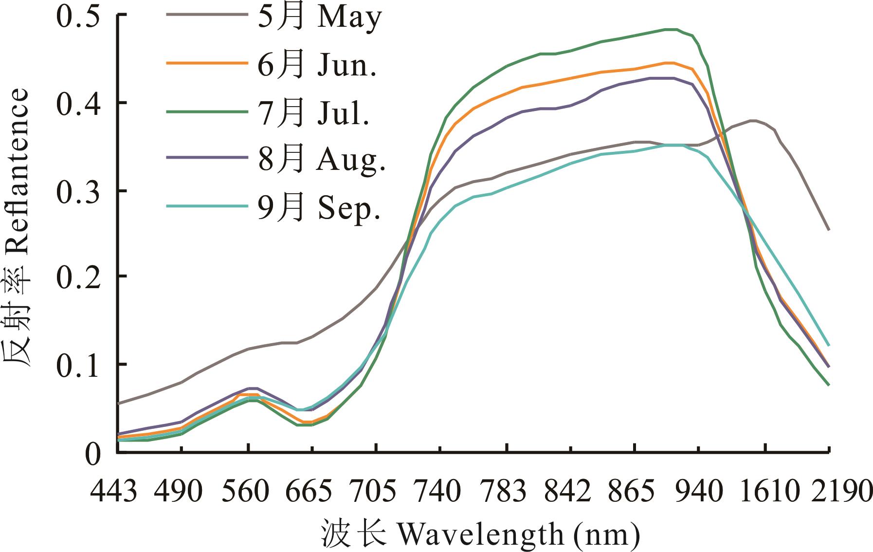
Fig.2 Spectral reflectance curves of nature grassland in different months
| LASSO ID | 变量Variables |
|---|---|
| LASSO 1 | B2, B6, B11, IRECI, PSSRa |
| LASSO 2 | B2, B8A, B11, EVI, TVI, REP, CARI, IRECI, PSSRa |
| LASSO 3 | B2, B11, EVI, CARI, IRECI, PSSRa |
| LASSO 4 | B2, B8A, B11, EVI, TVI, B11, IRECI, PSSRa |
| LASSO 5 | B2, B6, B11, EVI, IRECI, PSSRa |
Table 5 Results of important characteristic variables were selected by LASSO method
| LASSO ID | 变量Variables |
|---|---|
| LASSO 1 | B2, B6, B11, IRECI, PSSRa |
| LASSO 2 | B2, B8A, B11, EVI, TVI, REP, CARI, IRECI, PSSRa |
| LASSO 3 | B2, B11, EVI, CARI, IRECI, PSSRa |
| LASSO 4 | B2, B8A, B11, EVI, TVI, B11, IRECI, PSSRa |
| LASSO 5 | B2, B6, B11, EVI, IRECI, PSSRa |
| LASSO ID | 模型 Models | 训练集 Training set | 验证集 Validation set | ||
|---|---|---|---|---|---|
| T-R2 | T-RMSE (kg·hm-2) | V-R2 | V-RMSE (kg·hm-2) | ||
| LASSO 1 | RF | 0.93 | 316.937 | 0.72 | 622.616 |
| SVM | 0.69 | 656.276 | 0.66 | 698.271 | |
| ANN | 0.73 | 601.837 | 0.63 | 730.676 | |
| LASSO 2 | RF | 0.95 | 284.129 | 0.72 | 624.594 |
| SVM | 0.71 | 638.798 | 0.68 | 685.008 | |
| ANN | 0.83 | 477.670 | 0.67 | 686.136 | |
| LASSO 3 | RF | 0.94 | 296.973 | 0.71 | 625.002 |
| SVM | 0.69 | 655.849 | 0.66 | 691.631 | |
| ANN | 0.78 | 546.190 | 0.66 | 686.613 | |
| LASSO 4 | RF | 0.94 | 295.179 | 0.71 | 627.529 |
| SVM | 0.71 | 642.576 | 0.67 | 681.942 | |
| ANN | 0.81 | 501.278 | 0.67 | 695.866 | |
| LASSO 5 | RF | 0.94 | 294.397 | 0.72 | 632.793 |
| SVM | 0.69 | 659.055 | 0.66 | 691.451 | |
| ANN | 0.76 | 561.079 | 0.63 | 729.430 | |
Table 6 Model accuracy evaluation of five combinations of LASSO variables
| LASSO ID | 模型 Models | 训练集 Training set | 验证集 Validation set | ||
|---|---|---|---|---|---|
| T-R2 | T-RMSE (kg·hm-2) | V-R2 | V-RMSE (kg·hm-2) | ||
| LASSO 1 | RF | 0.93 | 316.937 | 0.72 | 622.616 |
| SVM | 0.69 | 656.276 | 0.66 | 698.271 | |
| ANN | 0.73 | 601.837 | 0.63 | 730.676 | |
| LASSO 2 | RF | 0.95 | 284.129 | 0.72 | 624.594 |
| SVM | 0.71 | 638.798 | 0.68 | 685.008 | |
| ANN | 0.83 | 477.670 | 0.67 | 686.136 | |
| LASSO 3 | RF | 0.94 | 296.973 | 0.71 | 625.002 |
| SVM | 0.69 | 655.849 | 0.66 | 691.631 | |
| ANN | 0.78 | 546.190 | 0.66 | 686.613 | |
| LASSO 4 | RF | 0.94 | 295.179 | 0.71 | 627.529 |
| SVM | 0.71 | 642.576 | 0.67 | 681.942 | |
| ANN | 0.81 | 501.278 | 0.67 | 695.866 | |
| LASSO 5 | RF | 0.94 | 294.397 | 0.72 | 632.793 |
| SVM | 0.69 | 659.055 | 0.66 | 691.451 | |
| ANN | 0.76 | 561.079 | 0.63 | 729.430 | |
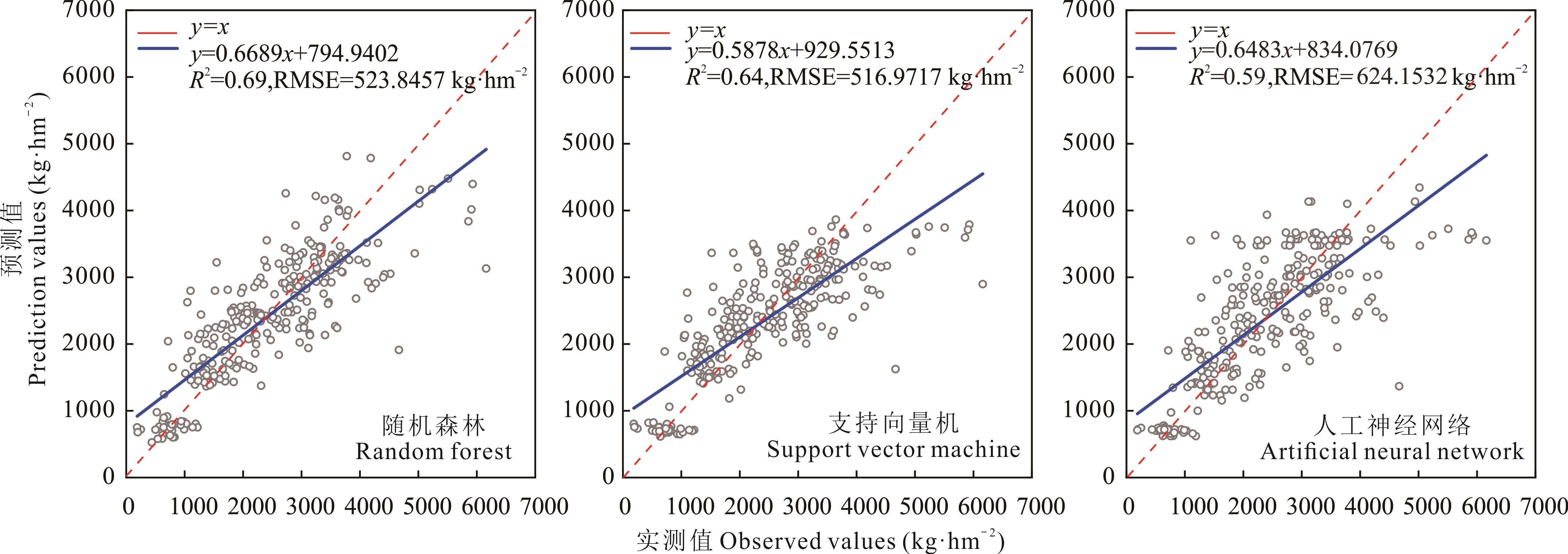
Fig.3 The validation results by comparing AGB predicted values and observed values based on machine learning model
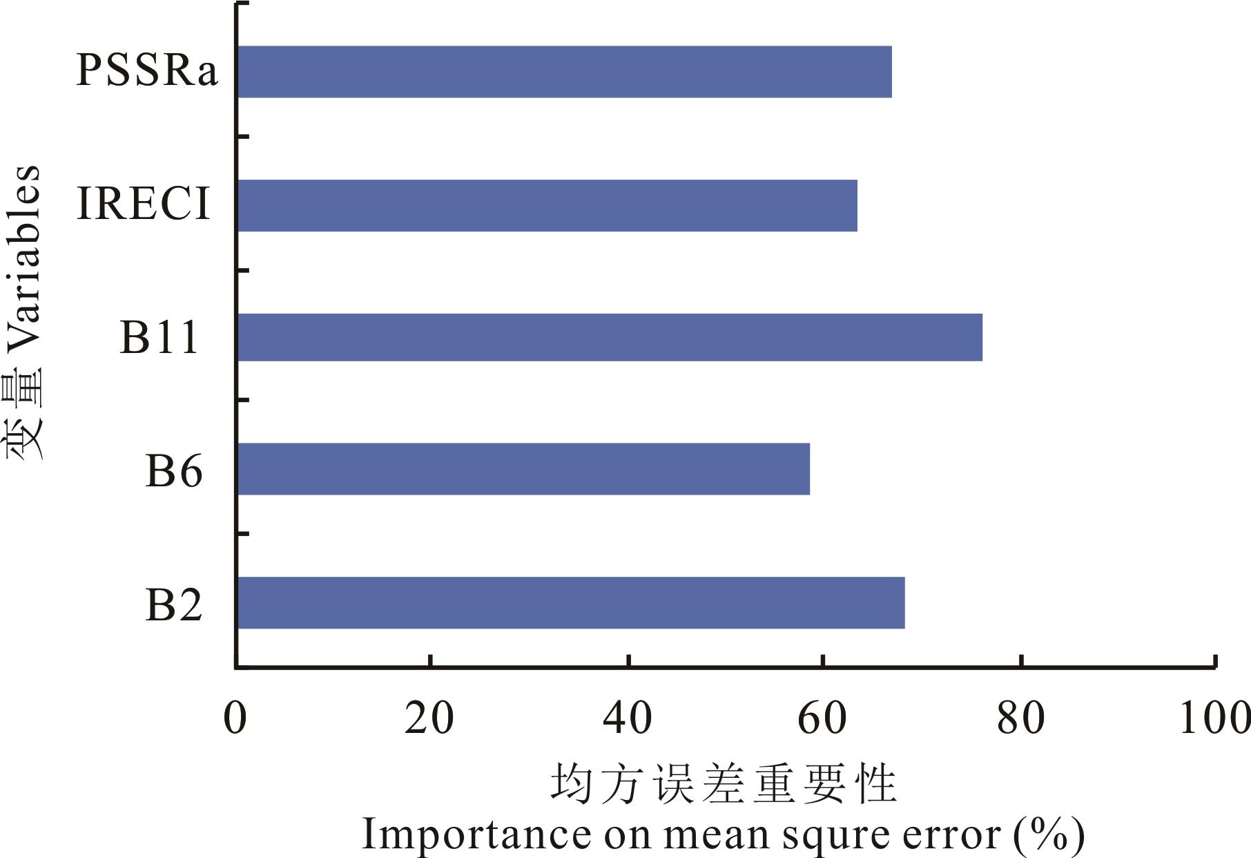
Fig.4 Importance ranking of variables

Fig.5 Spatial distribution of AGB of nature grassland in 2019, 2020 and 2021 in Menyuan County
年份 Year | 最小值 Minimum value (kg·hm-2) | 最大值 Maximum value (kg·hm-2) | 均值 Mean value (kg·hm-2) | 标准差 Standard deviation (kg·hm-2) | 总和 Sum ( |
|---|---|---|---|---|---|
| 2019 | 1035 | 5071 | 3471.49 | 517.13 | 1.41 |
| 2020 | 1158 | 5073 | 3544.00 | 512.41 | 1.44 |
| 2021 | 1154 | 5085 | 3360.26 | 425.35 | 1.37 |
Table 7 Nature grassland biomass in Menyuan County from 2019 to 2021
年份 Year | 最小值 Minimum value (kg·hm-2) | 最大值 Maximum value (kg·hm-2) | 均值 Mean value (kg·hm-2) | 标准差 Standard deviation (kg·hm-2) | 总和 Sum ( |
|---|---|---|---|---|---|
| 2019 | 1035 | 5071 | 3471.49 | 517.13 | 1.41 |
| 2020 | 1158 | 5073 | 3544.00 | 512.41 | 1.44 |
| 2021 | 1154 | 5085 | 3360.26 | 425.35 | 1.37 |
| 1 | Su D X. Rangeland resources decreases fast and its protection strategy in China//The 2nd symposium in the sixth term of Chinese grassland society and international grassland workshop. Chinese grassland society, Inner Mongolia autonomous region people’s government, national natural science foundation of China: Chinese grassland society, 2004: 48-51. |
| 苏大学. 我国草地资源快速消失与保护对策//中国草学会第六届二次会议暨国际学术研讨会论文集. 中国草学会、内蒙古自治区人民政府、国家自然科学基金委员会: 中国草学会, 2004: 48-51. | |
| 2 | Liu J, Yang J. Prediction and evaluation method of high cold meadow in Haibei area of Qinghai Province. Qinghai Prataculture, 2020, 29(4): 2-8. |
| 刘洁, 杨静. 青海省海北地区高寒草甸最高产量预测及评估方法研究. 青海草业, 2020, 29(4): 2-8. | |
| 3 | Jing X Q, Wang R H, Ren D Z, et al. Characteristics of three kinds of typical plant communities of the alpine meadow in Haibei Region, Qinghai Province. Acta Agrestia Sinica, 2017, 25(1): 190-194. |
| 井向前, 王瑞红, 任德智, 等. 青海海北3种典型高寒草甸植物群落特征研究. 草地学报, 2017, 25(1): 190-194. | |
| 4 | Fu J J, Zhou H K, Zhao X Q, et al. Clonal plants and their importance of different alpine grasslands in Haibei Region, Qinghai Province. Acta Agrestia Sinica, 2013, 21(6): 1065-1072. |
| 付京晶, 周华坤, 赵新全, 等. 青海海北不同类型高寒草地的克隆植物及其重要性. 草地学报, 2013, 21(6) : 1065-1072. | |
| 5 | Zheng Y, Wu B F, Zhang M. Estimating the above ground biomass of winter wheat using the Sentinel-2 data. National Remote Sensing Bulletin, 2017, 21(2): 318-328. |
| 郑阳, 吴炳方, 张淼. Sentinel-2数据的冬小麦地上干生物量估算及评价. 遥感学报, 2017, 21(2): 318-328. | |
| 6 | Bretas I L, Valente D S M, Silva F F, et al. Prediction of aboveground biomass and dry-matter content in brachiaria pastures by combining meteorological data and satellite imagery. Grass and Forage Science, 2021, 76(3): 340-352. |
| 7 | Tian X M, Zhang X L. Estimation of forest aboveground biomass by remote sensing. Journal of Beijing Forestry University, 2021, 43(8): 137-148. |
| 田晓敏, 张晓丽. 森林地上生物量遥感估算方法. 北京林业大学学报, 2021, 43(8): 137-148. | |
| 8 | Wang X Y, Li J, Xing L T. Comparative agricultural drought monitoring based on three machine learning methods. Arid Zone Research, 2022, 39(1): 322-332. |
| 王晓燕, 李净, 邢立亭. 基于3种机器学习方法的农业干旱监测比较. 干旱区研究, 2022, 39(1): 322-332. | |
| 9 | Xu M, Zhao Y X, Zhang G, et al. Method for forecasting winter wheat first flowering stage based on machine learning algorithm. Transactions of the Chinese Society of Agricultural Engineering, 2021, 37(11): 162-171. |
| 徐敏, 赵艳霞, 张顾, 等. 基于机器学习算法的冬小麦始花期预报方法. 农业工程学报, 2021, 37(11): 162-171. | |
| 10 | Wang N Y, Yu F H, Xu T Y, et al. Hyperspectral retrieval modelling for chlorophyll contents of japonica-rice leaves based on machine learning. Acta Agriculturae Zhejiangensis, 2020, 32(2): 359-366. |
| 王念一, 于丰华, 许童羽, 等. 基于机器学习的粳稻叶片叶绿素含量高光谱反演建模. 浙江农业学报, 2020, 32(2): 359-366. | |
| 11 | Huang F, Gao S, Yao X, et al. Estimation of winter wheat leaf nitrogen concentration using machine learning algorithm and multi-color space. Journal of Nanjing Agricultural University, 2020, 43(2): 364-371. |
| 黄芬, 高帅, 姚霞, 等. 基于机器学习和多颜色空间的冬小麦叶片氮含量估算方法研究. 南京农业大学学报, 2020, 43(2): 364-371. | |
| 12 | Drusch M, Del B U, Carlier S, et al. Sentinel-2: ESA’s optical high-resolution mission for GMES operational services. Remote Sensing of Environment, 2012, 120: 25-36. |
| 13 | SUHET. Sentinel-2 user handbook. Paris: European Space Agency, 2015. |
| 14 | Han B, Gao Y N, Guo Y, et al. Modeling aboveground biomass of alpine grassland in the three-river headwaters region based on remote sensing data. Research of Environmental Sciences, 2017, 30(1): 67-74. |
| 韩波, 高艳妮, 郭杨, 等. 三江源区高寒草地地上生物量遥感反演模型研究. 环境科学研究, 2017, 30(1): 67-74. | |
| 15 | Huang J X, Wu J, Li C B, et al. Remote sensing retrieval of grassland above-ground biomass in Tianzhu County based on Sentinel-2 and Landsat 8 data. Acta Agrestia Sinica, 2021, 29(9): 2023-2030. |
| 黄家兴, 吴静, 李纯斌, 等. 基于Sentinel-2和Landsat 8数据的天祝县草地地上生物量遥感反演. 草地学报, 2021, 29(9): 2023-2030. | |
| 16 | Qin Q, Xu D W, Hou L L, et al. Comparing vegetation indices from Sentinel-2 and Landsat 8 under different vegetation gradients based on a controlled grazing experimen. Ecological Indicators, 2021, 133: 108363. |
| 17 | Chen Y, Guerschman J, Shendryk Y, et al. Estimating pasture biomass using sentinel-2 imagery and machine learning. Remote Sensing, 2021, 13(603): 1-20. |
| 18 | Marildo G F, Tatiana M K, Fernando D Q. Estimating natural grassland biomass by vegetation indices using Sentinel 2 remote sensing data. International Journal of Remote Sensing, 2020, 41(8): 2861-2876. |
| 19 | Morais T G, Teixeira R F M, Figueiredo M, et al. The use of machine learning methods to estimate aboveground biomass of grasslands: A review. Ecological Indicators, 2021, 130: 108081 . |
| 20 | Bao X Y, Wang Y, Feng Q S, et al. Spatial distribution extraction of alfalfa based on Sentinel-2 and GF-1 images. Transactions of the Chinese Society of Agricultural Engineering, 2021, 37(16): 153-160. |
| 包旭莹, 王燕, 冯琦胜, 等. Sentinel-2和GF-1影像结合提取苜蓿空间分布. 农业工程学报, 2021, 37(16): 153-160. | |
| 21 | Yu H, Wu Y F, Niu L T, et al. A method to avoid spatial overfitting in estimation of grassland above-ground biomass on the Tibetan Plateau. Ecological Indicators, 2021, 125: 107450. |
| 22 | Zhao Y H, Hou P, Jiang J B, et al. Progress in quantitative inversion of vegetation ecological remote sensing parameters. National Remote Sensing Bulletin, 2021, 25(11): 2173-2197. |
| 赵燕红, 侯鹏, 蒋金豹, 等. 植被生态遥感参数定量反演研究方法进展. 遥感学报, 2021, 25(11): 2173-2197. | |
| 23 | Guo Z Q, Zhang X L, Wang Y T. Ability evaluation of coniferous forest aboveground biomass inversion using Sentinel-2A multiple characteristic variables. Journal of Beijing Forestry University, 2020, 42(11): 27-38. |
| 郭正齐, 张晓丽, 王月婷. Sentinel-2A多特征变量反演针叶林地上生物量能力评估. 北京林业大学学报, 2020, 42(11): 27-38. | |
| 24 | Rondeaux G, Steven M, Baret F. Optimization of soil-adjusted vegetation indices. Remote Sensing of Environment, 1996, 55(2): 95-107. |
| 25 | Zhou X S. Urban vegetation classification and biomass inversion based on Sentinel-2A data in Xuzhou. Xuzhou: China University of Mining and Technology, 2019. |
| 周希胜. 基于Sentinel-2A数据的徐州城市植被分类及生物量反演研究. 徐州: 中国矿业大学, 2019. | |
| 26 | Li C H, Zhou L Z, Xu W B. Estimating aboveground biomass using Sentinel-2 MSI data and ensemble algorithms for grassland in the Shengjin Lake wetland, China. Remote Sensing, 2021, 13: 1595. |
| 27 | Xing X Y, Yang X C, Xu B, et al. Remote sensing estimation of grassland aboveground biomass based on random forest. Journal of Geo-information Science, 2021, 23(7): 1312-1324. |
| 邢晓语, 杨秀春, 徐斌, 等. 基于随机森林算法的草原地上生物量遥感估算方法研究. 地球信息科学学报, 2021, 23(7): 1312-1324. | |
| 28 | Lei X D. Applications of machine learning algorithms in forest growth and yield prediction. Journal of Beijing Forestry University, 2019, 41(12): 23-36. |
| 雷相东. 机器学习算法在森林生长收获预估中的应用. 北京林业大学学报, 2019, 41(12): 23-36. | |
| 29 | Xiu X M, Zhou S F, Chen Q, et al. Above-ground biomass estimation of provincial scattered grassland based on Google Earth Engine and machine learning. Bulletin of Surveying and Mapping, 2019, 504(3): 46-52. |
| 修晓敏, 周淑芳, 陈黔, 等. 基于Google Earth Engine与机器学习的省级尺度零散分布草地生物量估算. 测绘通报, 2019, 504(3): 46-52. | |
| 30 | Baret F, Guyot G, Major D J. TSAVI: A vegetation index which minimizes soil brightness effects on LAI and APAR estimation. Geoscience and Remote Sensing Symposium, 1989. IGARSS’89. 12th Canadian Symposium on Remote Sensing, 1989 International. |
| 31 | Yang B, Li D, Wang L, et al. Retrieval of surface vegetation biomass information and analysis of vegetation feature based on Sentinel-2A in the upper of Minjiang River. Science & Technology Review, 2017, 35(21): 74-80. |
| 杨斌, 李丹, 王磊, 等. 基于Sentinel-2A岷江上游地表生物量反演与植被特征分析. 科技导报, 2017, 35(21): 74-80. | |
| 32 | Zhang G F, Yue C R, Zhang W Q. Above-ground biomass estimation in Kunming Dianchi lake wetland using Sentinel imagery. Journal of Terahertz Science and Electronic Information Technology, 2020, 18(1): 142-149. |
| 张国飞, 岳彩荣, 章皖秋. 基于Sentinel数据的滇池湖滨湿地地上生物量反演. 太赫兹科学与电子信息学报, 2020, 18(1): 142-149. | |
| 33 | Schwieder M, Buddeberg M, Kowalski K, et al. Estimating grassland parameters from Sentinel-2: A model comparison study. Pfg-Journal of Photogrammetry Remote Sensing and Geoinformation Science, 2020, 88(5): 379-390. |
| 34 | Xu X J, Zhang J Y, Chao M N, et al. Study on soybean biomass forecasting model based on canopy reflectance spectra. Heilongjiang Agricultural Sciences, 2017(9): 119-123. |
| 徐新娟, 张晋玉, 晁毛妮, 等. 基于冠层反射光谱的大豆生物量预测模型研究. 黑龙江农业科学, 2017(9): 119-123. | |
| 35 | Xu H, Bao Y H, Bao G, et al. Typical grassland of Inner Mongolia hay biomass hyper-spectral remote sensing estimation research. Yinshan Academic Journal (Natural Science Edition), 2014, 28(4): 22-27. |
| 胥慧, 包玉海, 包刚, 等. 内蒙古典型草原干草生物量高光谱遥感估算研究. 阴山学刊(自然科学版), 2014, 28(4): 22-27. | |
| 36 | Jiang H L, Yang H, Chen X P, et al. Research on accuracy and stability of inversing vegetation chlorophyll content by spectral index method. Spectroscopy and Spectral Analysis, 2015, 35(4): 975-981. |
| 姜海玲, 杨杭, 陈小平, 等. 利用光谱指数反演植被叶绿素含量的精度及稳定性研究. 光谱学与光谱分析, 2015, 35(4): 975-981. | |
| 37 | Fang C Y, Wang L, Xu H Q. A comparative study of different red edge indices for remote sensing detection of Urban grassland health status. Journal of Geo-Information Science, 2017, 19(10): 1382-1392. |
| 方灿莹, 王琳, 徐涵秋. 不同植被红边指数在城市草地健康判别中的对比研究. 地球信息科学学报, 2017, 19(10): 1382-1392. | |
| 38 | Zhao J S, Li W, Wang W S, et al. Analysis on saturation of Suaeda salsa vegetation index based on DART model. Journal of Central China Normal University (Natural Sciences), 2021, 55(1): 121-127. |
| 赵健顺, 李微, 王文硕, 等. 基于DART模型的盐地碱蓬植被指数饱和问题分析. 华中师范大学学报(自然科学版), 2021, 55(1): 121-127. | |
| 39 | Xia Y, Fan J R, Zhang X Y, et al. Application of composite vegetation index in remote sensing inversion of sparse fractional vegetation cover in alpine steppe. Pratacultural Science, 2017, 34(9): 1767-1777. |
| 夏颖, 范建容, 张茜彧, 等. 复合植被指数在稀疏高寒草原植被盖度遥感反演中的应用. 草业科学, 2017, 34(9): 1767-1777. | |
| 40 | Shuai S, Zhang Z, Lv X B, et al. Remote sensing monitoring of vegetation phenological characteristics and vegetation health status in mine restoration areas. Transactions of the Chinese Society of Agricultural Engineering, 2021, 37(4): 224-234. |
| 帅爽, 张志, 吕新彪, 等. 矿山恢复治理区植被物候与健康状况遥感监测. 农业工程学报, 2021, 37(4): 224-234. | |
| 41 | Xu Z Y, Li Y C, Li M Y, et al. Forest biomass retrieval based on Sentinel-1A and Landsat 8 image. Journal of Central South University of Forestry & Technology, 2020, 40(11): 147-155. |
| 许振宇, 李盈昌, 李明阳, 等. 基于Sentinel-1A和Landsat 8数据的区域森林生物量反演. 中南林业科技大学学报,2020,40(11): 147-155. | |
| 42 | Ramoelo A, Cho M A, Mathieu R, et al. Monitoring grass nutrients and biomass as indicators of rangeland quality and quantity using random forest modelling and WorldView-2 data. International journal of applied earth observation and geoinformation, 2015, 43: 43-54. |
| 43 | Wu F, Li Y X, Zhang Y Y et al. Hyperspectral estimation of biomass of winter wheat at difference growth stages based on machine learning algorithms. Journal of Triticeae Crops, 2019, 39(2): 217-224. |
| 吴芳, 李映雪, 张缘园, 等. 基于机器学习算法的冬小麦不同生育时期生物量高光谱估算. 麦类作物学报, 2019, 39(2): 217-224. | |
| 44 | Gao H Y, Hou M J, Ge J, et al. Hyperspectral estimation of aboveground biomass of alpine grassland based on random forest algorithm. Acta Agrestia Sinica, 2021, 29(8): 1757-1768. |
| 高宏元, 侯蒙京, 葛静, 等. 基于随机森林的高寒草地地上生物量高光谱估算. 草地学报, 2021, 29(8): 1757-1768. |
| [1] | Fang-zhen LI, Hua-ping ZHONG, Ke-hui OUYANG, Xiao-min ZHAO, Yu-zhe LI. Estimation and digital mapping of grassland belowground biomass in the Altay region, China, based on machine learning [J]. Acta Prataculturae Sinica, 2022, 31(8): 13-23. |
| [2] | Yi-han ZHAO, Meng-jing HOU, Qi-sheng FENG, Hong-yuan GAO, Tian-gang LIANG, Jin-sheng HE, Da-wen QIAN. Estimation of aboveground biomass in Menyuan grassland based on Landsat 8 and random forest approach [J]. Acta Prataculturae Sinica, 2022, 31(7): 1-14. |
| [3] | Ge-xia QIN, Jing WU, Chun-bin LI, Zhen-xia JI, Zheng-chao QIU, Ying LI. Inversion of grassland aboveground biomass in Tianzhu Zangzu Autonomous County based on a machine learning algorithm [J]. Acta Prataculturae Sinica, 2022, 31(4): 177-188. |
| [4] | Zhe-ren JIN, Qi-sheng FENG, Rui-jing WANG, Tian-gang LIANG. A study of grassland aboveground biomass on the Tibetan Plateau using MODIS data and machine learning [J]. Acta Prataculturae Sinica, 2022, 31(10): 1-17. |
| [5] | Jing-jing MA, Yun-hua LIU, Jian-dong SHENG, Ning LI, Hong-qi WU, Hong-tao JIA, Zong-jiu SUN, Jun-hui CHENG. Changes of relationships between dominant species and their relative biomass along elevational gradients in Xinjiang grasslands [J]. Acta Prataculturae Sinica, 2021, 30(8): 25-35. |
| [6] | Yi-ran ZHANG, Ting-xi LIU, Xin TONG, Li-min DUAN, Yu-chen WU. Hyperspectral remote sensing inversion of meadow aboveground biomass based on an XGBoost algorithm [J]. Acta Prataculturae Sinica, 2021, 30(4): 1-12. |
| [7] | Dian-dai ZHANG, Xue-mei WANG, Mei ZAN. Estimation of vegetation aboveground biomass in the Wei-Ku Oasis based on Landsat 8 OLI images [J]. Acta Prataculturae Sinica, 2021, 30(11): 1-12. |
| [8] | Hui-fang ZHAO, Xiao-dong LI, Dong ZHANG, Rui-xiang XIAO. Aboveground biomass in grasslands in Qinghai Province estimated from MODIS data and its influencing factors [J]. Acta Prataculturae Sinica, 2020, 29(12): 5-16. |
| [9] | WANG Chun-yan, YAN Xia, GU Meng-he. The interaction effects of vegetation and soil nutrients on vegetation succession in abandoned farmland on the Loess Plateau [J]. Acta Prataculturae Sinica, 2018, 27(11): 26-35. |
| [10] | ZHAO Jie, LI Wei, JING Guang-Hua, WEI Lin, CHENG Ji-Min. Responses of species diversity and aboveground biomass to nitrogen addition in fenced and grazed grassland on the Loess Plateau [J]. Acta Prataculturae Sinica, 2017, 26(8): 54-64. |
| [11] | GE Jing, MENG Bao-Ping, YANG Shu-Xia, GAO Jin-Long, YIN Jian-Peng, ZHANG Ren-Ping, FENG Qi-Sheng, LIANG Tian-Gang. Monitoring of above-ground biomass in alpine grassland based on agricultural digital camera and MODIS remote sensing data: A case study in the Yellow River Headwater Region [J]. Acta Prataculturae Sinica, 2017, 26(7): 23-34. |
| [12] | JING Mei-Ling, MA Yu-Shou, LI Shi-Xiong, WANG Yan-Long. Initial assessment of sixteen perennial grass species in the upper Datong River [J]. Acta Prataculturae Sinica, 2017, 26(6): 76-88. |
| [13] | GE Jing, MENG Bao-Ping, YANG Shu-Xia, GAO Jin-Long, FENG Qi-Sheng, LIANG Tian-Gang, HUANG Xiao-Dong, GAO Xin-Hua, LI Wen-Long, ZHANG Ren-Ping, WANG Yun-Long. Dynamic monitoring of alpine grassland coverage based on UAV technology and MODIS remote sensing data-A case study in the headwaters of the Yellow River [J]. Acta Prataculturae Sinica, 2017, 26(3): 1-12. |
| [14] | SUN Yong-Xiu, YAN Cheng, XU Hai-Liang, YAO Yan-Li. Grassland community species diversity and aboveground biomass responses to difference in cover soil thickness in restoration after mining damage [J]. Acta Prataculturae Sinica, 2017, 26(1): 54-62. |
| [15] | YANG Shu-Xia, ZHANG Wen-Juan, FENG Qi-Sheng, MENG Bao-Ping, GAO Jin-Long, LIANG Tian-Gang. Monitoring of grassland herbage accumulation by remote sensing using MODIS daily surface reflectance data in the Qingnan Region [J]. Acta Prataculturae Sinica, 2016, 25(8): 14-26. |
| Viewed | ||||||
|
Full text |
|
|||||
|
Abstract |
|
|||||