
ISSN 1004-5759 CN 62-1105/S
Acta Prataculturae Sinica ›› 2026, Vol. 35 ›› Issue (2): 1-14.DOI: 10.11686/cyxb2025108
Previous Articles Next Articles
Lin-xing ZHAO1( ), Yan-he WANG1, Zi-chao WANG2, Ma-qiang XU1(), Ze-yu LI1, Chang-xian QI1, Bao-zu CUI1, Zong-bao WANG1
Received:2025-03-27
Revised:2025-04-21
Online:2026-02-20
Published:2025-12-24
Contact:
Ma-qiang XU
Lin-xing ZHAO, Yan-he WANG, Zi-chao WANG, Ma-qiang XU, Ze-yu LI, Chang-xian QI, Bao-zu CUI, Zong-bao WANG. Dynamic monitoring of land degradation in the Three-River Headwaters Region over the past 30 years using unoccupied aerial vehicle imagery and Landsat data[J]. Acta Prataculturae Sinica, 2026, 35(2): 1-14.
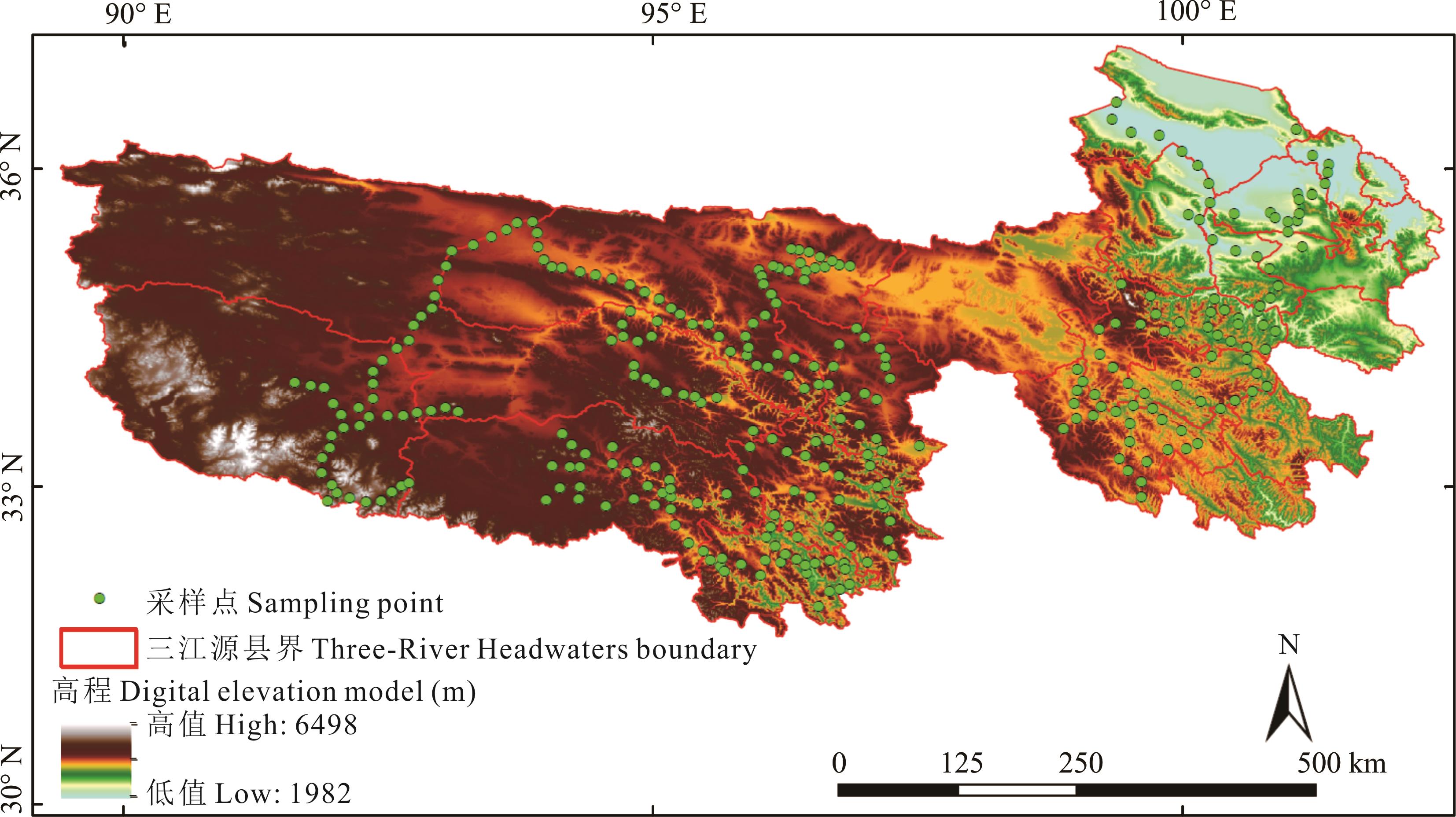
Fig. 1 Spatial distribution of research area and sampling points
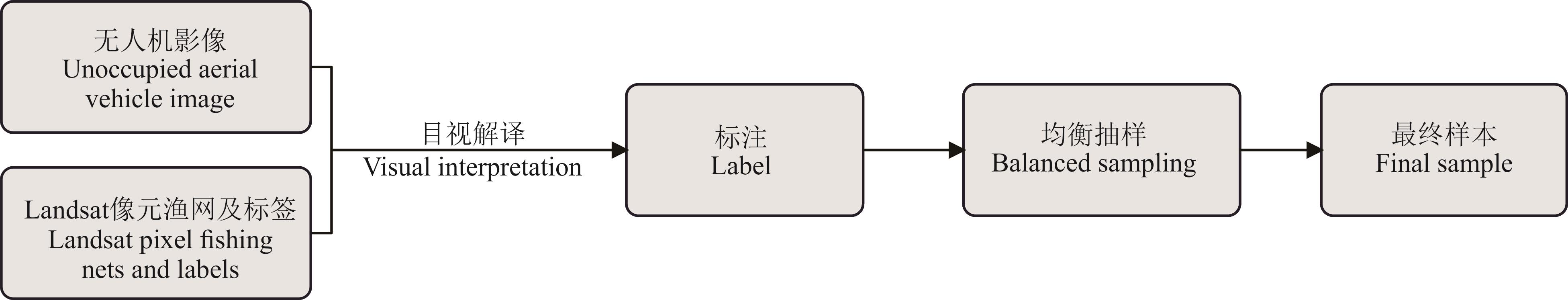
Fig.2 Visual interpretation process of unoccupied aerial vehicle data
情景 Scene | 遥感特征类型 Remote sensing feature types | 特征 Feature |
|---|---|---|
| 情景1 Scene 1 | 光谱波段Spectral band | 蓝波段Blue、绿波段Green、红波段Red、近红外波段NIR、短波红外1波段SWIR1、短波红外2波段SWIR2 |
| 情景2 Scene 2 | 指数特征Index feature | 归一化植被指数NDVI、比值植被指数RVI、增强型植被指数EVI、修正型土壤调节植被指数MSAVI、裸土指数BSI、过量绿色植被指数EXG、归一化绿蓝差异指数NGBDI、归一化绿红差异指数NGRDI、可见抗大气指数VARI、绿红比率指数GRRI、植被盖度FVC |
| 情景3 Scene 3 | 地形数据Terrain data | 高程DEM、坡度Slope、坡向Aspect |
Table 1 Remote sensing features required for the model
情景 Scene | 遥感特征类型 Remote sensing feature types | 特征 Feature |
|---|---|---|
| 情景1 Scene 1 | 光谱波段Spectral band | 蓝波段Blue、绿波段Green、红波段Red、近红外波段NIR、短波红外1波段SWIR1、短波红外2波段SWIR2 |
| 情景2 Scene 2 | 指数特征Index feature | 归一化植被指数NDVI、比值植被指数RVI、增强型植被指数EVI、修正型土壤调节植被指数MSAVI、裸土指数BSI、过量绿色植被指数EXG、归一化绿蓝差异指数NGBDI、归一化绿红差异指数NGRDI、可见抗大气指数VARI、绿红比率指数GRRI、植被盖度FVC |
| 情景3 Scene 3 | 地形数据Terrain data | 高程DEM、坡度Slope、坡向Aspect |
沙化等级 Desertification level | 特征描述 Characteristic description |
|---|---|
未沙化土地 Non-desertified land | 植被覆盖度在70%以上;Landsat像元主要是绿色或浅红色。The vegetation coverage is above 70%; Landsat pixels are mainly green or light red. |
轻度沙化土地 Slightly desertified land | 植被覆盖度大于40%,小于70%;固定或半固定沙丘为主;Landsat像元主要为浅绿色。The vegetation coverage is between 40% and 70%; the area is mainly composed of fixed or semi-fixed dunes; Landsat pixels are primarily light green. |
中度沙化土地 Moderately desertified land | 植被覆盖度大于20%,小于40%;大部分为半固定沙丘,出现明显的风蚀坑;Landsat像元主要为黄色。The vegetation coverage is between 20% and 40%; most of the area consists of semi-fixed dunes with noticeable wind erosion pits; Landsat pixels are primarily yellow. |
重度沙化土地 Severely desertified land | 植被覆盖度低于20%;大部分是流动或半流动沙丘,带有大型风蚀坑;Landsat像元大部分像素是浅黄色和白色。The vegetation coverage is below 20%; most of the area consists of mobile or semi-mobile dunes with large wind erosion pits; Landsat pixels are primarily light yellow and white. |
Table 2 Visual interpretation signs of desertified land
沙化等级 Desertification level | 特征描述 Characteristic description |
|---|---|
未沙化土地 Non-desertified land | 植被覆盖度在70%以上;Landsat像元主要是绿色或浅红色。The vegetation coverage is above 70%; Landsat pixels are mainly green or light red. |
轻度沙化土地 Slightly desertified land | 植被覆盖度大于40%,小于70%;固定或半固定沙丘为主;Landsat像元主要为浅绿色。The vegetation coverage is between 40% and 70%; the area is mainly composed of fixed or semi-fixed dunes; Landsat pixels are primarily light green. |
中度沙化土地 Moderately desertified land | 植被覆盖度大于20%,小于40%;大部分为半固定沙丘,出现明显的风蚀坑;Landsat像元主要为黄色。The vegetation coverage is between 20% and 40%; most of the area consists of semi-fixed dunes with noticeable wind erosion pits; Landsat pixels are primarily yellow. |
重度沙化土地 Severely desertified land | 植被覆盖度低于20%;大部分是流动或半流动沙丘,带有大型风蚀坑;Landsat像元大部分像素是浅黄色和白色。The vegetation coverage is below 20%; most of the area consists of mobile or semi-mobile dunes with large wind erosion pits; Landsat pixels are primarily light yellow and white. |
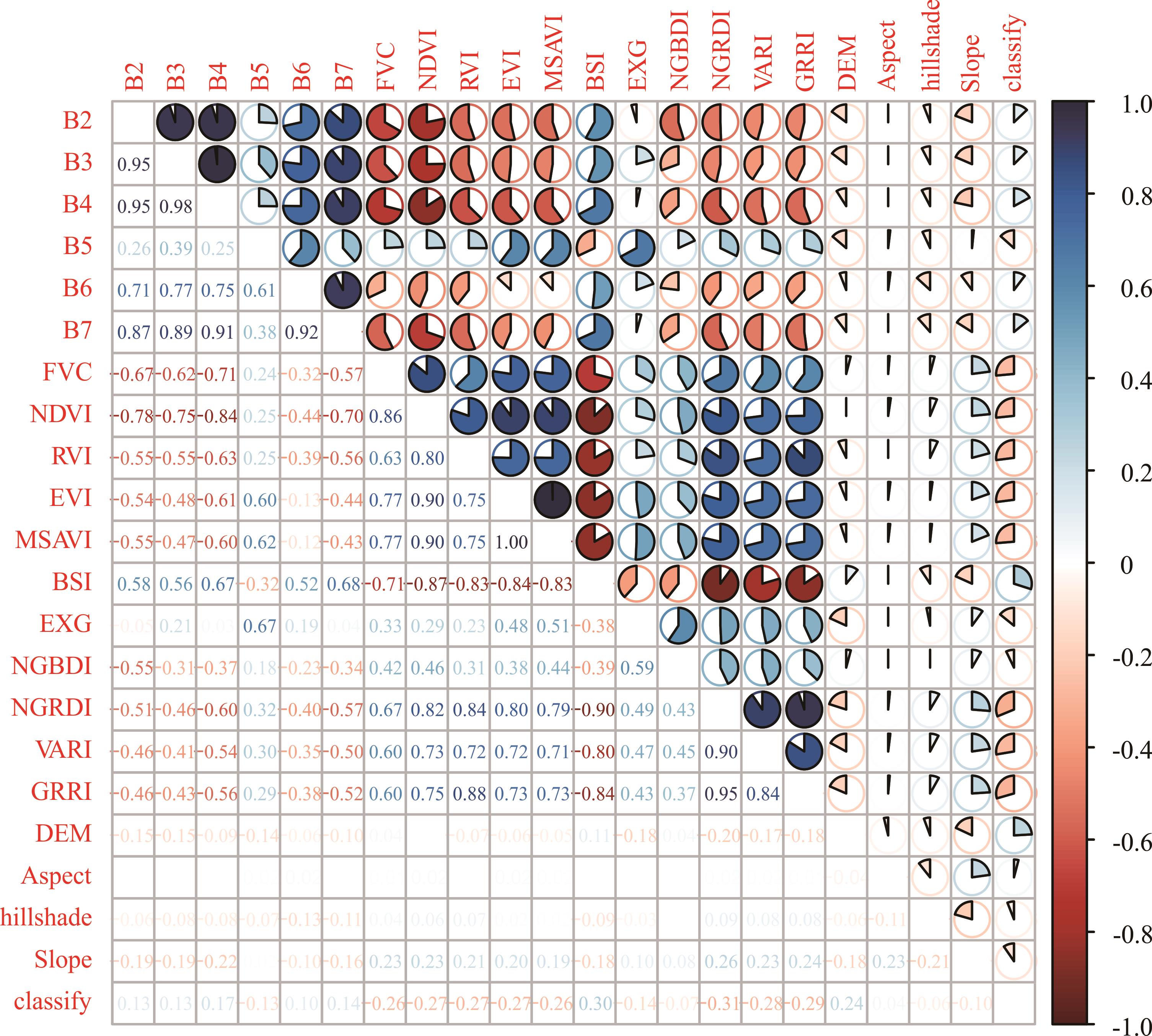
Fig.3 Pearson correlation coefficient
情景 Scene | 总体准确率 Overall accuracy (%) | 类型 Type | 精确率 Precision (%) | F1分数 F1 score (%) |
|---|---|---|---|---|
情景1 Scene 1 | 82.65 | 未退化 Non-degraded | 84.75 | 81.13 |
| 黑土滩型退化 Black soil beach-type degradation | 79.01 | 88.04 | ||
| 沙化型退化 Desertification-type degradation | 87.88 | 89.61 | ||
| 其他类型退化 Other types of degradation | 79.08 | 69.51 | ||
情景2 Scene 2 | 85.00 | 未退化 Non-degraded | 84.65 | 84.77 |
| 黑土滩型退化 Black soil beach-type degradation | 80.06 | 88.45 | ||
| 沙化型退化 Desertification-type degradation | 91.96 | 92.33 | ||
| 其他类型退化 Other types of degradation | 84.24 | 72.48 | ||
情景1+情景2 Scene 1+scene 2 | 86.88 | 未退化 Non-degraded | 85.87 | 85.48 |
| 黑土滩型退化 Black soil beach-type degradation | 82.61 | 90.19 | ||
| 沙化型退化 Desertification-type degradation | 93.48 | 93.34 | ||
| 其他类型退化 Other types of degradation | 86.30 | 77.24 | ||
情景1+情景2+情景3 Scene 1+scene 2+scene 3 | 92.85 | 未退化 Non-degraded | 92.48 | 92.34 |
| 黑土滩型退化 Black soil beach-type degradation | 90.98 | 95.18 | ||
| 沙化型退化 Desertification-type degradation | 94.73 | 95.85 | ||
| 其他类型退化 Other types of degradation | 93.31 | 87.46 |
Table 3 Random forest model accuracy evaluation
情景 Scene | 总体准确率 Overall accuracy (%) | 类型 Type | 精确率 Precision (%) | F1分数 F1 score (%) |
|---|---|---|---|---|
情景1 Scene 1 | 82.65 | 未退化 Non-degraded | 84.75 | 81.13 |
| 黑土滩型退化 Black soil beach-type degradation | 79.01 | 88.04 | ||
| 沙化型退化 Desertification-type degradation | 87.88 | 89.61 | ||
| 其他类型退化 Other types of degradation | 79.08 | 69.51 | ||
情景2 Scene 2 | 85.00 | 未退化 Non-degraded | 84.65 | 84.77 |
| 黑土滩型退化 Black soil beach-type degradation | 80.06 | 88.45 | ||
| 沙化型退化 Desertification-type degradation | 91.96 | 92.33 | ||
| 其他类型退化 Other types of degradation | 84.24 | 72.48 | ||
情景1+情景2 Scene 1+scene 2 | 86.88 | 未退化 Non-degraded | 85.87 | 85.48 |
| 黑土滩型退化 Black soil beach-type degradation | 82.61 | 90.19 | ||
| 沙化型退化 Desertification-type degradation | 93.48 | 93.34 | ||
| 其他类型退化 Other types of degradation | 86.30 | 77.24 | ||
情景1+情景2+情景3 Scene 1+scene 2+scene 3 | 92.85 | 未退化 Non-degraded | 92.48 | 92.34 |
| 黑土滩型退化 Black soil beach-type degradation | 90.98 | 95.18 | ||
| 沙化型退化 Desertification-type degradation | 94.73 | 95.85 | ||
| 其他类型退化 Other types of degradation | 93.31 | 87.46 |
方法 Method | 总体准确率 Overall accuracy (%) | 类型 Type | 精确率 Precision (%) | F1分数 F1 score (%) |
|---|---|---|---|---|
支持向量机 Support vector machine (SVM) | 70.38 | 未退化 Non-degraded | 98.74 | 47.53 |
| 黑土滩型退化 Black soil beach-type degradation | 98.46 | 97.32 | ||
| 沙化型退化 Desertification-type degradation | 99.47 | 71.49 | ||
| 其他类型退化 Other types of degradation | 45.78 | 62.45 | ||
分类回归树 Classification and regression tree (CART) | 72.00 | 未退化 Non-degraded | 87.69 | 77.29 |
| 黑土滩型退化 Black soil beach-type degradation | 58.14 | 71.28 | ||
| 沙化型退化 Desertification-type degradation | 83.19 | 81.15 | ||
| 其他类型退化 Other types of degradation | 70.41 | 56.80 | ||
随机森林 Random forest (RF) | 92.85 | 未退化 Non-degraded | 92.48 | 92.34 |
| 黑土滩型退化 Black soil beach-type degradation | 90.98 | 95.18 | ||
| 沙化型退化 Desertification-type degradation | 94.73 | 95.85 | ||
| 其他类型退化 Other types of degradation | 93.31 | 87.46 |
Table 4 Comparison of accuracy of different algorithms in scenario 1+scenario 2+scenario 3
方法 Method | 总体准确率 Overall accuracy (%) | 类型 Type | 精确率 Precision (%) | F1分数 F1 score (%) |
|---|---|---|---|---|
支持向量机 Support vector machine (SVM) | 70.38 | 未退化 Non-degraded | 98.74 | 47.53 |
| 黑土滩型退化 Black soil beach-type degradation | 98.46 | 97.32 | ||
| 沙化型退化 Desertification-type degradation | 99.47 | 71.49 | ||
| 其他类型退化 Other types of degradation | 45.78 | 62.45 | ||
分类回归树 Classification and regression tree (CART) | 72.00 | 未退化 Non-degraded | 87.69 | 77.29 |
| 黑土滩型退化 Black soil beach-type degradation | 58.14 | 71.28 | ||
| 沙化型退化 Desertification-type degradation | 83.19 | 81.15 | ||
| 其他类型退化 Other types of degradation | 70.41 | 56.80 | ||
随机森林 Random forest (RF) | 92.85 | 未退化 Non-degraded | 92.48 | 92.34 |
| 黑土滩型退化 Black soil beach-type degradation | 90.98 | 95.18 | ||
| 沙化型退化 Desertification-type degradation | 94.73 | 95.85 | ||
| 其他类型退化 Other types of degradation | 93.31 | 87.46 |
年份 Year | 未退化 Non-degraded | 黑土滩型退化 Black soil beach-type degradation | 沙化型退化 Desertification-type degradation | 盐渍型退化 Salinization degradation |
|---|---|---|---|---|
| 1993 | 75781.8747 | 44293.1067 | 223330.4289 | 107463.0735 |
| 2003 | 91086.8787 | 53386.1712 | 179527.6494 | 110216.2338 |
| 2013 | 101463.3261 | 59735.6037 | 171860.2281 | 90162.9081 |
| 2023 | 94859.8380 | 57372.4323 | 170713.3590 | 105526.4580 |
Table 5 Statistics of various types of degraded areas (km2)
年份 Year | 未退化 Non-degraded | 黑土滩型退化 Black soil beach-type degradation | 沙化型退化 Desertification-type degradation | 盐渍型退化 Salinization degradation |
|---|---|---|---|---|
| 1993 | 75781.8747 | 44293.1067 | 223330.4289 | 107463.0735 |
| 2003 | 91086.8787 | 53386.1712 | 179527.6494 | 110216.2338 |
| 2013 | 101463.3261 | 59735.6037 | 171860.2281 | 90162.9081 |
| 2023 | 94859.8380 | 57372.4323 | 170713.3590 | 105526.4580 |

Fig. 4 Distribution of land degradation types in Three-River Headwaters region
年份 Year | 未退化 Non-degraded | 轻度退化 Slight degradation | 中度退化 Moderate degradation | 重度退化 Severe degradation |
|---|---|---|---|---|
| 1993 | 75781.8747 | 92374.6311 | 119822.5017 | 162889.4763 |
| 2003 | 91086.8787 | 87078.9942 | 90068.4612 | 165982.5990 |
| 2013 | 101463.3261 | 91723.8735 | 82493.1720 | 147541.6944 |
| 2023 | 94859.8380 | 104022.7740 | 90080.8839 | 139508.5914 |
Table 6 Statistics on the area of various degradation levels (km2)
年份 Year | 未退化 Non-degraded | 轻度退化 Slight degradation | 中度退化 Moderate degradation | 重度退化 Severe degradation |
|---|---|---|---|---|
| 1993 | 75781.8747 | 92374.6311 | 119822.5017 | 162889.4763 |
| 2003 | 91086.8787 | 87078.9942 | 90068.4612 | 165982.5990 |
| 2013 | 101463.3261 | 91723.8735 | 82493.1720 | 147541.6944 |
| 2023 | 94859.8380 | 104022.7740 | 90080.8839 | 139508.5914 |

Fig. 5 Distribution of land degradation levels in the Three-River Headwaters region

Fig. 6 Transfer situation of land degradation types and areas in the Three-River Headwaters region
| [1] | Ren Q, He C Y, Huang Q X, et al. Impacts of urban expansion on natural habitats in global drylands. Nature Sustainability, 2022, 5(10): 869-878. |
| [2] | Peng W Y, Li B J, Liu C. Xi Jinping’s important exposition on ecological security and the construction of ecological security system. Chinese Journal of Urban and Enviromental Studies, 2021(1): 20-34. |
| 彭文英, 李碧君, 刘灿. 习近平关于生态安全重要论述及生态安全体系建设研究. 城市与环境研究, 2021(1): 20-34. | |
| [3] | Chen Y N, Li Z Q, Xu J H, et al. Changes and protection suggestions in water resources and ecological environment in arid region of Northwest China. Bulletin of Chinese Academy of Sciences, 2023, 38(3): 385-393. |
| 陈亚宁, 李忠勤, 徐建华, 等.中国西北干旱区水资源与生态环境变化及保护建议. 中国科学院院刊, 2023, 38(3): 385-393. | |
| [4] | Food and Agriculture Organization of the United Nations. Land degradation. Rome: Food and Agriculture Organization of the United Nations, 1971. |
| [5] | Chen A, Yang X C, Guo J, et al. Synthesized remote sensing-based desertification index reveals ecological restoration and its driving forces in the northern sand-prevention belt of China. Ecological Indicators, 2021, 131: 108230. |
| [6] | Wang Z, Song D X, He T, et al. Developing spatial and temporal continuous fractional vegetation cover based on Landsat and Sentinel-2 data with a deep learning approach. Remote Sensing, 2023, 15(11): 2948. |
| [7] | Zhong G R, Chen J J, Huang R J, et al. High spatial resolution fractional vegetation coverage inversion based on UAV and Sentinel-2 data: A case study of alpine grassland. Remote Sensing, 2023, 15(17): 4266. |
| [8] | Gao X C. Research on rodent damage and degradation of desert grassland based on UAV hyperspectral remote sensing. Hohhot: Inner Mongolia Agricultural University, 2024. |
| 高新超. 基于无人机高光谱遥感的荒漠草原鼠害及退化研究. 呼和浩特: 内蒙古农业大学, 2024. | |
| [9] | Jin E E D M T. Research on identification and inversion of degradation indicator of desert grassland based on hyperspectral remote sensing by unmanned aerial vehicle. Hohhot: Inner Mongolia Agricultural University, 2024. |
| 金额尔都木吐. 基于无人机高光谱遥感的荒漠草原退化指示地物识别与反演研究. 呼和浩特: 内蒙古农业大学, 2024. | |
| [10] | Wang H J, Fan W J, Cui Y K, et al. Hyperspectral remote sensing monitoring of grassland degradation. Spectroscopy and Spectral Analysis, 2010, 30(10): 2734-2738. |
| 王焕炯, 范闻捷, 崔要奎, 等. 草地退化的高光谱遥感监测方法. 光谱学与光谱分析, 2010, 30(10): 2734-2738. | |
| [11] | Liu X D, Liu R T, Liu A J, et al. Study on information extraction and the dynamic monitoring of grassland coverage in Three River Source area. Acta Agrestia Sinica, 2010, 18(2): 154-159. |
| 刘晓东, 刘荣堂, 刘爱军, 等.三江源地区草地覆盖遥感信息提取方法及动态研究. 草地学报, 2010, 18(2): 154-159. | |
| [12] | Li Y J, Zhang L. Sandy land monitoring method based on classification index model. Journal of Geo-information Science, 2021, 23(4): 680-691. |
| 李宇君, 张磊. 基于沙地指数模型的沙地监测方法. 地球信息科学学报, 2021, 23(4): 680-691. | |
| [13] | Zhang Q, Zhou H K, Wang X L, et al. Research on comprehensive definition and classification of degraded grassland of black soil beach cased on morphology-vegetation-soil characteristics. Qinghai Science and Technology, 2023, 30(5): 19-26. |
| 张强, 周华坤, 王晓丽, 等. 基于形态-植被-土壤特征的黑土滩退化草地综合定义与分类方法研究. 青海科技, 2023, 30(5): 19-26. | |
| [14] | Chen G M. The status of the degraded pasture and its strategyes of management in black beach of the headwater region of the Three River. Journal of Grassland and Forage Science, 2005(10): 37-39, 44. |
| 陈国明. 三江源地区“黑土滩”退化草地现状及治理对策. 四川草原, 2005(10): 37-39, 44. | |
| [15] | Ma Y S, Lang B N, Wang Q J. Review and prospect of the study on ‘black soil type’ deteriorated grassland. Pratacultural Science, 1999(2): 5-9. |
| 马玉寿, 郎百宁, 王启基. “黑土型”退化草地研究工作的回顾与展望. 草业科学, 1999(2): 5-9. | |
| [16] | Dang X P, Dong Y. Study on the dynamic changes of desertification land in the Three Rivers Source region of Qinghai Province. Inner Mongolia Forestry Investigation and Design, 2017, 40(6): 20-26. |
| 党晓鹏, 东雨. 青海省三江源地区沙化土地变化动态研究. 内蒙古林业调查设计, 2017, 40(6): 20-26. | |
| [17] | Shang Z H, Long R J. Formation reason and recovering problem of the‘black soil type’degraded alpine grassland in Qinghai Tibetan Plateau. Chinese Journal of Ecology, 2005(6): 652-656. |
| 尚占环, 龙瑞军. 青藏高原“黑土型”退化草地成因与恢复. 生态学杂志, 2005(6): 652-656. | |
| [18] | Shang Z H, Dong Q M, Shi J J, et al. Research progress in recent ten years of ecological restoration for “black soil land” degraded grassland on Tibetan Plateau-Concurrently discuss of ecological restoration in Sanjiangyuan region. Acta Agrestia Sinica, 2018, 26(1): 1-21. |
| 尚占环, 董全民, 施建军, 等. 青藏高原“黑土滩”退化草地及其生态恢复近10年研究进展——兼论三江源生态恢复问题. 草地学报, 2018, 26(1): 1-21. | |
| [19] | Yu Z R, Wang J W. Land salinization in China and the prevention countermeasures. Rural Eco-Environment, 1997, 13(3): 2-6. |
| 宇振荣, 王建武. 中国土地盐碱化及其防治对策研究. 农村生态环境, 1997, 13(3): 2-6. | |
| [20] | Ma H W, Wang Y F, Guo E L. Remote sensing monitoring of aeolian desertification in Ongniud Banner based on GEE. Arid Zone Research, 2023, 40(3): 504-516. |
| 马浩文, 王永芳, 郭恩亮. 基于GEE的翁牛特旗土地沙漠化遥感监测. 干旱区研究, 2023, 40(3): 504-516. | |
| [21] | Xia L, Song X N, Cai S H, et al. Role of surface hydrothermal elements in grassland degradation over the Tibetan Plateau. Acta Ecologica Sinica, 2021, 41(11): 4618-4631. |
| 夏龙, 宋小宁, 蔡硕豪, 等. 地表水热要素在青藏高原草地退化中的作用. 生态学报, 2021, 41(11): 4618-4631. | |
| [22] | He H X, Yan J N, Liang D, et al. Time-series land cover change detection using deep learning-based temporal semantic segmentation. Remote Sensing of Environment, 2024, 305: 114101. |
| [23] | Li Z M, Chen B, Wu S B, et al. Deep learning for urban land use category classification: A review and experimental assessment. Remote Sensing of Environment, 2024, 311: 114290. |
| [24] | Gao G Y, Liang Y, Liu J B, et al. A modified RUSLE model to simulate soil erosion under different ecological restoration types in the loess hilly area. International Soil and Water Conservation Research, 2024, 12(2): 258-266. |
| [25] | Qiu H H, Hu B Q, Zhang Z. Impacts of land use change on ecosystem service value based on SDGs report-Taking Guangxi as an example. Ecological Indicators, 2021, 133: 108366. |
| [26] | Misuk K, KyuBaek H. An empirical evaluation of sampling methods for the classification of imbalanced data. PLoS One, 2022, 17(7): e0271260. |
| [27] | Millard K, Richardson M. On the importance of training data sample selection in random forest image classification: A case study in peatland ecosystem mapping. Remote Sensing, 2015, 7(7): 8489-8515. |
| [28] | Wang F, Ding J L, Wu M C. Remote sensing monitoring models of soil salinization based on NDVI-SI feature space. Transactions of the Chinese Society of Agricultural Engineering, 2010, 26(8): 168-173, 8. |
| 王飞, 丁建丽, 伍漫春. 基于NDVI-SI特征空间的土壤盐渍化遥感模型. 农业工程学报, 2010, 26(8): 168-173, 8. | |
| [29] | Breiman L. Bagging predictors. Machine Learning, 1996, 24: 123-140. |
| [30] | Cortes C, Vapnik V. Support-vector networks. Machine Learning, 1995, 20: 273-297. |
| [31] | Breiman L, Friedman J, Olshen R A, et al. Classification and regression trees. Routledge, 2017.https://doi.org/10.1201/9781315139470. |
| [32] | National Technical Committee on Desertification Control Standardization (SAC/TC 365). Specification for types and classification of land degradation: LY/T 3354-2023. Beijing: China Standards Press, 2023. |
| 全国荒漠化防治标准化技术委员会(SAC/TC 365). 土地退化类型与分级规范: LY/T 3354-2023. 北京: 中国标准出版社, 2023. | |
| [33] | Liu K Y, Zhao Z Y, Li L. Research progress in the application of SAR data in soil salinity monitoring. Journal of Geo-information Science, 2024, 26(8): 1893-1910. |
| 刘康怡, 赵振宇, 李俐. SAR数据在土壤盐渍化监测中的应用研究进展.地球信息科学学报, 2024, 26(8): 1893-1910. | |
| [34] | Chen A, Xu C, Zhang M, et al. Cross-scale mapping of above-ground biomass and shrub dominance by integrating UAV and satellite data in temperate grassland. Remote Sensing of Environment, 2024, 304: 114024. |
| [35] | Li W K, Zhao Q H, Jia S H, et al. Multi-feature and multi-level Sentinel-2 image extraction of lake and reservoir water bodies on Liaoning Province. Bulletin of Surveying and Mapping, 2024(3): 37-42, 106. |
| 李文康, 赵泉华, 贾淑涵, 等. 多特征多层次Sentinel-2影像辽宁省湖库水体提取. 测绘通报, 2024(3): 37-42, 106. |
| [1] | Jian-min RAN, Xiao-yan SONG, Dan WANG, Chang-ting WANG. Changes in soil organic carbon fractions and carbon sequestration potential of degraded alpine meadows [J]. Acta Prataculturae Sinica, 2025, 34(9): 38-52. |
| [2] | Long YIN, Qi-fei HAN, Yang ZHAO, Wen-xin LIU. Identification of areas of Aconitum leucostomum incursion and monitoring of grassland degradation in the Tuohulasu grassland of Xinjiang based on multi feature fusion [J]. Acta Prataculturae Sinica, 2025, 34(12): 73-84. |
| [3] | Yuan-jun LUO, Yu-lin PU, Da-gang YUAN, Ya-li LI, Hong-yu QIAN. Evolution of soil phosphorus forms and factors influencing their formation based on 31P nuclear magnetic resonance analyses of degraded alpine wetland [J]. Acta Prataculturae Sinica, 2024, 33(2): 1-12. |
| [4] | Fang LI, Guang-jun WANG, Hai-bo DU, Meng LI, Si-hai LIANG, Hong-ming PENG. Integrating MODIS and Landsat data to reconstruct the Landsat NDVI of a typical region in the Qinghai Lake Basin and changes in the intra-annual NDVI maximum [J]. Acta Prataculturae Sinica, 2023, 32(8): 28-39. |
| [5] | Feng HAN, Zhi-tao ZHANG, Xin ZHANG, Jian-hao WANG, Hao WANG. Legal process and governance of public rangelands: Experiences and implications from America [J]. Acta Prataculturae Sinica, 2022, 31(9): 220-232. |
| [6] | Yi-han ZHAO, Meng-jing HOU, Qi-sheng FENG, Hong-yuan GAO, Tian-gang LIANG, Jin-sheng HE, Da-wen QIAN. Estimation of aboveground biomass in Menyuan grassland based on Landsat 8 and random forest approach [J]. Acta Prataculturae Sinica, 2022, 31(7): 1-14. |
| [7] | Yu-zhuo ZHANG, Zhi-gui YANG, Hong-yan YU, Qiang ZHANG, Shu-xia YANG, Ting ZHAO, Hua-hua XU, Bao-ping MENG, Yan-yan LV. Estimating grassland above ground biomass based on the STARFM algorithm and remote sensing data——A case study in the Sangke grassland in Xiahe County, Gansu Province [J]. Acta Prataculturae Sinica, 2022, 31(6): 23-34. |
| [8] | Chuan-qi WANG, Wen-hui LIU, Yong-chao ZHANG, Qing-ping ZHOU. Drought tolerance of wild Elymus nutans during germination and seedling establishment [J]. Acta Prataculturae Sinica, 2021, 30(9): 76-85. |
| [9] | Cheng-yi LI, Xi-lai LI, Yuan-wu YANG, Hong-lin LI, De-fei LIANG. Effect of nitrogen addition on soil bacterial diversity in alpine degraded grasslands of differing slope [J]. Acta Prataculturae Sinica, 2020, 29(12): 161-170. |
| [10] | LIU Ya-jing, MENG Zhong-ju, DANG Xiao-hong, SONG Wen-juan, ZHAI Bo. Allelopathic effects of Stellera chamaejasme on seed germination and seedling growth of alfalfa and two forage grasses [J]. Acta Prataculturae Sinica, 2019, 28(8): 130-138. |
| [11] | WU Ting-mei, WU Yuan, WANG Duo-bin, LIN Hui-long. Influence of herders’ livelihood capital on livelihood strategies in the Three-River Headwaters region [J]. Acta Prataculturae Sinica, 2019, 28(11): 12-21. |
| [12] | ZHANG Yong, YANG Zi-hui, GUO Shu-jiang, WANG Qiang-qiang, ZHAN Ke-jie, ZHANG Jian-hui, WEI Huai-dong. Ecological changes in the Minqin oasis belt over the past 20 years [J]. Acta Prataculturae Sinica, 2018, 27(7): 14-24. |
| [13] | WANG Xue-xia, DONG Shi-kui, GAO Qing-zhu, ZHANG Yong, HU Guo-zheng, LUO Wen-rong. The rate of soil nitrogen transformation decreased by the degradation of alpine grasslands in the Qinghai Tibet Plateau [J]. Acta Prataculturae Sinica, 2018, 27(6): 1-9. |
| [14] | CAO Wei, LIU Lu-lu, WU Dan. Soil erosion changes and driving factors in the Three-River Headwaters region [J]. Acta Prataculturae Sinica, 2018, 27(6): 10-22. |
| [15] | XUN Qi-lei, DONG Yi-qiang, AN Sha-zhou, YAN Kai. Monitoring of grassland herbage accumulation by remote sensing using MOD 09GA data in Xinjiang [J]. Acta Prataculturae Sinica, 2018, 27(4): 10-26. |
| Viewed | ||||||
|
Full text |
|
|||||
|
Abstract |
|
|||||