
ISSN 1004-5759 CN 62-1105/S
Acta Prataculturae Sinica ›› 2022, Vol. 31 ›› Issue (1): 1-12.DOI: 10.11686/cyxb2020510
Ren-ping ZHANG1,2( ), Jing GUO3, Xiao-fang MA4, Wei-yong GUO5
Received:2020-11-17
Revised:2021-01-27
Online:2021-12-01
Published:2021-12-01
Contact:
Ren-ping ZHANG
Ren-ping ZHANG, Jing GUO, Xiao-fang MA, Wei-yong GUO. Grassland phenology extraction for Xinjiang Province and trend analysis using MODIS data[J]. Acta Prataculturae Sinica, 2022, 31(1): 1-12.

Fig.1 Distributions of the grasslands and ground observation points in Xinjiang

Fig.2 The comparison between phenology observed in the ground stations and phenology extracted by asymmetric gaussian, double logistic, Savitzky-Golay and MCD12Q2 retrieval

Fig.3 Distribution of the standard deviation of SOS in Xinjiang inverted by different methods
物候时间 Phenological time (d) | 非对称性高斯函数拟合法 Asymmetric gaussian | 双逻辑斯蒂函数拟合法 Double logistic | S-G滤波法 Savitzky-Golay | 物候产品数据 MCD12Q2 |
|---|---|---|---|---|
| <15 | 42.0 | 40.7 | 37.3 | 85.0 |
| 15~30 | 40.2 | 35.8 | 30.7 | 11.8 |
| 30~45 | 12.6 | 15.0 | 19.7 | 2.6 |
| 45~60 | 4.2 | 6.8 | 8.3 | 0.4 |
| >60 | 1.0 | 1.6 | 4.1 | 0.2 |
Table1 Standard deviation area ratio of SOS inverted by different methods (%)
物候时间 Phenological time (d) | 非对称性高斯函数拟合法 Asymmetric gaussian | 双逻辑斯蒂函数拟合法 Double logistic | S-G滤波法 Savitzky-Golay | 物候产品数据 MCD12Q2 |
|---|---|---|---|---|
| <15 | 42.0 | 40.7 | 37.3 | 85.0 |
| 15~30 | 40.2 | 35.8 | 30.7 | 11.8 |
| 30~45 | 12.6 | 15.0 | 19.7 | 2.6 |
| 45~60 | 4.2 | 6.8 | 8.3 | 0.4 |
| >60 | 1.0 | 1.6 | 4.1 | 0.2 |
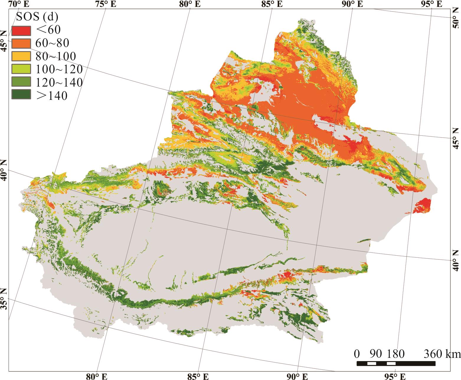
Fig.4 Spatial distribution of SOS in Xinjiang based on A-G method
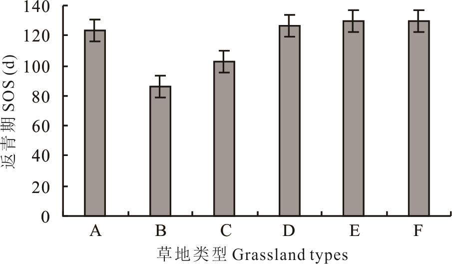
Fig.5 Multi-year mean values of SOS for different grassland types based on the A-G method
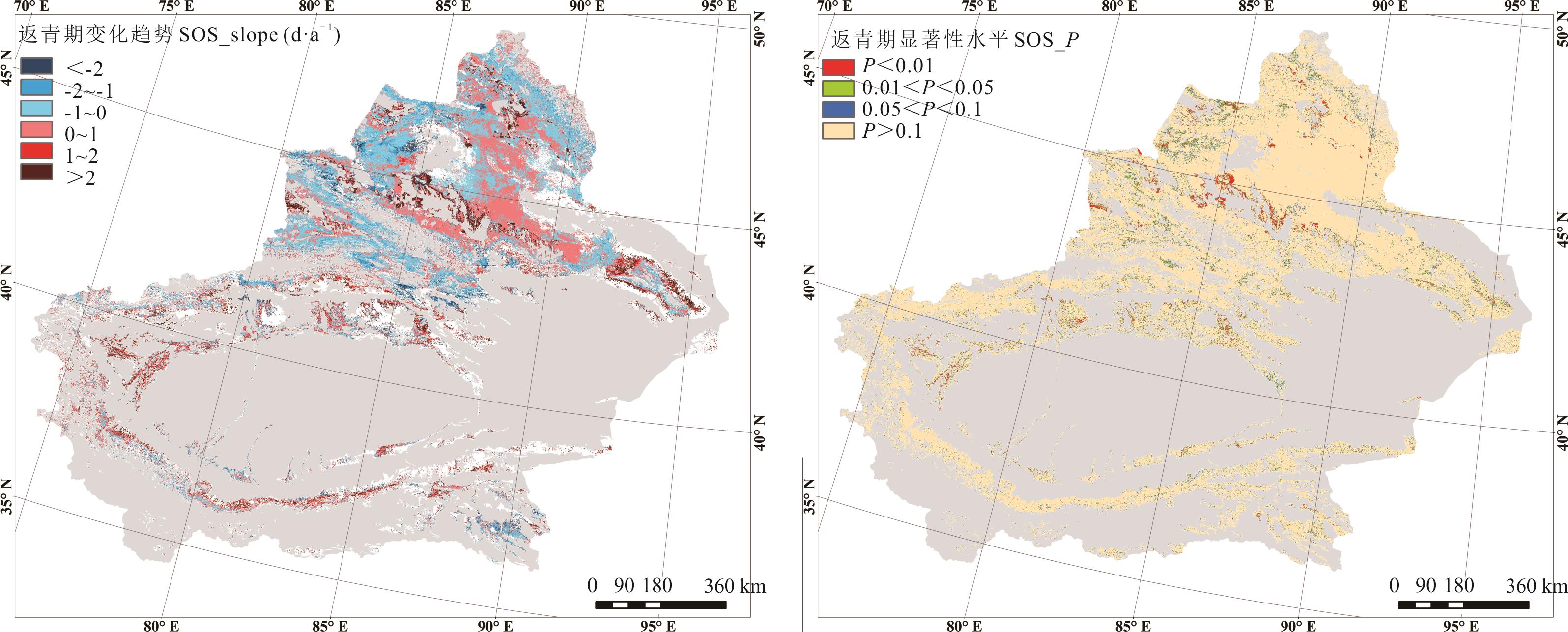
Fig.6 Variation trend and significance test of grassland SOS in Xinjiang based on A-G method

Fig.7 The interannual variation trend of SOS in different grassland types based on A-G method
| 1 | Lu P L, Yu Q, He Q T. Responses of plant phenology to climate change. Acta Ecologica Sinica, 2006, 26(3): 923-929. |
| 陆佩玲, 于强, 贺庆棠. 植物物候对气候变化的响应. 生态学报, 2006, 26(3): 923-929. | |
| 2 | Wang L X, Chen H L, Li Q, et al. Research advances in plant phenology and climate. Acta Ecologica Sinica, 2010, 30(2): 447-454. |
| 王连喜, 陈怀亮, 李琪, 等. 植物物候与气候研究进展. 生态学报, 2010, 30(2): 447-454. | |
| 3 | Jeong S J, Ho C H, Gim H J, et al. Phenology shifts at start vs end of growing season in temperate vegetation over the Northern Hemisphere for the period 1982-2008. Global Change Biology, 2011, 17(7): 2385-2399. |
| 4 | Wan M W, Liu X Z. Phenological observation methods in China. Beijing: Science Press, 1987. |
| 宛敏渭, 刘秀珍. 中国物候观测方法. 北京: 科学出版社, 1987. | |
| 5 | Verbesselt J, Hyndman R, Culvenor D, et al. Detecting trend and seasonal changes in satellite image time series. Transactions of the Chinese Society of Agricultural Engineering, 2010, 114(1): 106-115. |
| 6 | Chen X Q, Hu B, Yu R. Spatial and temporal variation of phonological growing season and climate change impacts in temperate Eastern China. Global Change Biology, 2005, 11: 1118-1130. |
| 7 | Julien Y, Sobrino J A, Verhoef W. Changes in land surface temperatures and NDVI values over Europe between 1982 and 1999. Remote Sensing of Environment, 2006, 103(1): 43-55. |
| 8 | Sellers P J. Canopy reflectance, photosynthesis and transpiration. International Journal of Remote Sensing, 1985, 6(8): 1335-1372. |
| 9 | Ma X P, Bai H Y, He Y N, et al. The vegetation remote sensing phenology of Qinling Mountains based on NDVI and it’s response to temperature: Taking within the territory of Shanxi as an example. Scientia Geographica Sinica, 2015, 35(12): 1616-1621. |
| 马新萍, 白红英, 贺映娜, 等. 基于NDVI的秦岭山地植被遥感物候及其与气温的响应关系——以陕西境内为例. 地理科学, 2015, 35(12): 1616-1621. | |
| 10 | Li P. Dynamics of vegetation autumn phenology and their response to extremely climate change in the Qinghai-Tibet Plateau. Xianyang: Northwest A & F University, 2017. |
| 李鹏. 青藏高原植被枯黄期的时空变化及其对极端气候事件的响应. 咸阳: 西北农林科技大学, 2017. | |
| 11 | Cihlar J, Ly H, Li Z Q, et al. Multitemporal, multichannel AVHRR data sets for land biosphere studies-artifacts and corrections. Remote Sensing of Environment, 1997, 60: 35-57. |
| 12 | Zhou Z G, Tang P. Ⅵ-quality-based Savitzky-Golay method for filtering time series data. Remote Sensing Technology and Application, 2013, 28(2): 232-239. |
| 周增光, 唐娉. 基于质量权重的Savitzky-Golay时间序列滤波方法. 遥感技术与应用, 2013, 28(2): 232-239. | |
| 13 | Liu J W, Zhou Y K. Comparison and application of NDVI time-series reconstruction methods at site scale on the Tibetan Plateau. Progress in Geography, 2018, 37(3): 427-437. |
| 刘建文, 周玉科. 站点尺度的青藏高原时序NDVI重构方法比较与应用. 地理科学进展, 2018, 37(3): 427-437. | |
| 14 | Gu Z H. Research on remote sensing estimation method of China’s multiple cropping index-based on SPOT/VGT multi-temporal NDVI remote sensing data. Beijing: Beijing Normal University, 2003. |
| 辜智慧. 中国农作物复种指数的遥感估算方法研究——基于SPOT/VGT多时相NDVI遥感数据.北京: 北京师范大学, 2003. | |
| 15 | Liu Y N, Xiao F, Du Y. Analysis of four time series EVI data reconstruction methods. Acta Ecologica Sinica, 2016, 36(15): 4672-4679. |
| 刘亚南, 肖飞, 杜耘. 基于秦岭样区的4种时序EVI函数拟合方法对比研究. 生态学报, 2016, 36(15): 4672-4679. | |
| 16 | Zhang X Y, Friedl M A, Schaaf C B, et al. Monitoring vegetation phenology using MODIS. Remote Sensing of Environment, 2003, 84: 471-475. |
| 17 | Xiao W W, Sun Z G, Wang Q X, et al. Evaluating MODIS phenology product for rotating croplands through ground observations. Journal of Applied Remote Sensing, 2013, 7(1): 609-618. |
| 18 | Begue A, Vintrou E, Saad A, et al. Differences between cropland and rangeland MODIS phenology (start-of-season) in Mali. International Journal of Applied Earth Observation & Geoinformation, 2014, 31(1): 167-170. |
| 19 | Delbart N, Toan T L, Kergoat L, et al. Remote sensing of spring phenology in boreal regions: A free of snow-effect method using NOAA-AVHRR and SPOT-VGT data (1982-2004). Remote Sensing of Environment, 2006, 101(1): 52-62. |
| 20 | Zeng H, Jia G, Epstein H. Recent changes in phenology over the northern high latitudes detected from multi-satellite data. Environmental Research Letters, 2011, 6(4): 45508-45518. |
| 21 | Wang H, Li X B, Ying G, et al. The variability of vegetation growing season in the northern China based on NOAA NDVI and MSAVI from 1982 to 1999. Acta Ecologica Sinica, 2007, 27(2): 504-515. |
| 王宏, 李晓兵, 莺歌, 等. 基于NOAANDVI和MSAVI研究中国北方植被生长季变化. 生态学报, 2007, 27(2): 504-515. | |
| 22 | Ni L, Wu J, Li C B, et al. Temporal and spatial variations in natural grassland phenology in China over the last 30 years. Acta Prataculturae Sinica, 2020, 29(1): 1-12. |
| 倪璐, 吴静, 李纯斌, 等. 近30年中国天然草地物候时空变化特征分析. 草业学报, 2020, 29(1): 1-12. | |
| 23 | He B Z, Ding J L, Li H, et al. Spatiotemporal variation of vegetation phenology in Xinjiang from 2001 to 2016. Acta Ecologica Sinica, 2018, 38(6): 2139-2155. |
| 何宝忠, 丁建丽, 李焕, 等. 新疆植被物候时空变化特征. 生态学报, 2018, 38(6): 2139-2155. | |
| 24 | Zhang R P, Guo J, Feng Q S, et al. Spatio-temporal variations in grassland vegetation phenology in Xinjiang. Acta Prataculturae Sinica, 2018, 27(10): 66-75. |
| 张仁平, 郭靖, 冯琦胜, 等. 新疆地区草地植被物候时空变化. 草业学报, 2018, 27(10): 66-75. | |
| 25 | Savitzky A, Golay M J E. Smoothing and differentiation of data by simplified least squares procedures. Analytical Chemistry, 1964, 36(8): 1627-1639. |
| 26 | Jonsson P, Eklundh L. Seasonality extraction by function fitting to time-series of satellite sensor data. IEEE Transaction on Geoscience and Remote Sensing, 2002, 40(8): 1824-1832. |
| 27 | Beck P, Atzberer C, Hogda K, et al. Improved monitoring of vegetation dynamics at very high latitudes: A new method using MODIS NDVI. Remote Sensing of Environment, 2006, 100(3): 321-334. |
| 28 | Xia C F, Li J, Liu Q H. Review of advance in vegetation phenology monitoring by remote sensing. Journal of Remote Sensing, 2013, 17(1): 1-16. |
| 夏传福, 李静, 柳钦火. 植被物候遥感监测研究进展. 遥感学报, 2013, 17(1): 1-16. | |
| 29 | Ma Y G, Zhang C, Tiiyip Tashpolat. Spatial-temporal change of land surface phenology in Central Asia arid zone. Arid Land Geography, 2014, 37(2): 310-317. |
| 马勇刚, 张弛, 塔西甫拉提·特依拜. 中亚区域陆表植被物候时空变化特征分析. 干旱区地理, 2014, 37(2): 310-317. | |
| 30 | Li D K, Wang Z. Spatiotemporal variation of vegetation phenology and its response to climate in Qinling Mountains based on MCD12Q2. Ecology and Environment Sciences, 2020, 29(1): 11-22. |
| 李登科, 王钊. 基于MCD12Q2的秦岭植被物候时空变化及对气候的响应. 生态环境学报, 2020, 29(1): 11-22. | |
| 31 | Wu N T, Liu G X, Yang Y, et al. Dynamic monitoring of net primary productivity and its response to climate factors in native grassland in Inner Mongolia using a light-use efficiency model. Acta Prataculturae Sinica, 2020, 29(11): 1-10. |
| 乌尼图, 刘桂香, 杨勇, 等. 基于光能利用率模型的内蒙古天然草原植被净初级生产力动态监测与气候因子的响应. 草业学报, 2020, 29(11): 1-10. | |
| 32 | Zhang C, Yan H F, Takase K, et al. Comparison of the soil physical properties and hydrological processes in two different forest type catchments. Water Resources, 2016, 43(1): 225-237. |
| 33 | Huang S. Parametrization of resistances for modeling crop transpiration and soil evaporation in the Southern Jiangsu. Zhenjiang: Jiangsu University, 2020. |
| 黄松. 苏南地区典型作物蒸腾和土面蒸发模型及参数的研究. 镇江: 江苏大学, 2020. | |
| 34 | Wang Y Y, Yuan J G, Zhang Y, et al. Temporal and spatial variation of vegetation phenology in temperate China and its impact on gross primary productivity. Remote Sensing Technology and Application, 2019, 34(2): 377-388. |
| 王莹莹, 袁金国, 张莹, 等. 中国温带地区植被物候期时空变化特征及对总初级生产力的影响. 遥感技术与应用, 2019, 34(2): 377-388. | |
| 35 | Wen G, Fu C B. Large scale features of the seasonal phenological responses to the monsoon climate in East China: Multi-year average results. Chinese Journal of Atmospheric Sciences, 2000, 24(5): 676-683. |
| 温刚, 符淙斌. 中国东部季风区植被物候季节变化对气候响应的大尺度特征: 多年平均结果. 大气科学, 2000, 24(5): 676-683. | |
| 36 | An Y Z. Vegetation NDVI and phenology change in Northern China based remote sensing. Shanghai: East China Normal University, 2014. |
| 安佑志. 基于遥感的中国北部植被NDVI和物候变化研究. 上海: 华东师范大学, 2014. | |
| 37 | Piao S L, Cui M D, Chen A P, et al. Altitude and temperature dependence of change in the spring vegetation green-up data from 1982 to 2006 in the Qinghai-Xizang Plateau. Agriculture and Forest Meteorology, 2011, 151(12): 1599-1608. |
| 38 | Zhang W, Bao G, Bao Y H. Vegetation SOS dynamic monitoring in Inner Mongolia from 1982 to 2013 and its responses to climate changes. China Agricultural Informatics, 2018, 30(2): 63-75. |
| 张雯, 包刚, 包玉海. 1982-2013年内蒙古植被返青期动态监测及其对气候变化的响应. 中国农业信息, 2018, 30(2): 63-75. |
| [1] | Xin YANG, Wen-xia CAO, Xiao-jun YU, Hai-bin WANG, Yuan-yuan HAO. Dynamic monitoring of grassland resources and their responses to environmental factors in Qinghai Province based on analyses of daily MODIS NDVI data from the past 20 years [J]. Acta Prataculturae Sinica, 2021, 30(9): 1-14. |
| [2] | Ting-mei WU, Hui-long LIN, Di FAN, Chang-ting JI, Yu-ting ZHAO, Jing-qiong WEI. Factors influencing the scale of herdsmen’s livestock farming in tundra alpine grassland-A case study from Qinghai Province [J]. Acta Prataculturae Sinica, 2021, 30(9): 117-126. |
| [3] | Jia-li LIU, Jian-rong FAN, Xi-yu ZHANG, Chao YANG, Fu-bao XU, Xiao-xue ZHANG, Bo LIANG. Remote sensing estimation of vegetation cover in alpine grassland in the growing and non-growing seasons [J]. Acta Prataculturae Sinica, 2021, 30(9): 15-26. |
| [4] | Mei-ling SONG, Yu-qin WANG, Hong-sheng WANG, Gen-sheng Bao. Effect of Epichloë endophyte on the litter decomposition of Stipa purpurea in alpine grassland [J]. Acta Prataculturae Sinica, 2021, 30(9): 150-158. |
| [5] | Qing ZHANG, Lu-yao LIU, Xue XU, Peng HAN, Yan-yun ZHAO, Jian-ming NIU, Yong DING. Sustainable development of family ranches in the Inner Mongolian grassland [J]. Acta Prataculturae Sinica, 2021, 30(9): 168-181. |
| [6] | Gang FU, Jun-hao WANG, Shao-wei LI, Ping HE. Responses of forage nutrient quality to grazing in the alpine grassland of Northern Tibet [J]. Acta Prataculturae Sinica, 2021, 30(9): 38-50. |
| [7] | Jing-dong ZHAO, Wuyunna, Yan-tao SONG. Effect of short-term fencing on the forage quality of plant communities in degraded grassland in Northwestern Liaoning [J]. Acta Prataculturae Sinica, 2021, 30(9): 51-61. |
| [8] | Hui-long LIN, Yan-fei PU, Dan-ni WANG, Hai-li MA. Index insurances for grasslands: A review and the Chinese scheme design [J]. Acta Prataculturae Sinica, 2021, 30(8): 171-185. |
| [9] | Jing-jing MA, Yun-hua LIU, Jian-dong SHENG, Ning LI, Hong-qi WU, Hong-tao JIA, Zong-jiu SUN, Jun-hui CHENG. Changes of relationships between dominant species and their relative biomass along elevational gradients in Xinjiang grasslands [J]. Acta Prataculturae Sinica, 2021, 30(8): 25-35. |
| [10] | Jing-dong ZHAO, Yan-tao SONG, Xin-lei XU, Wuyunna. Effects of nitrogen application and mowing on yield and quality of forage in degraded grassland in northwest Liaoning Province [J]. Acta Prataculturae Sinica, 2021, 30(8): 36-48. |
| [11] | Shuai CHANG, Hong-bo YU, Qiao-feng ZHANG, Zi-ce MA, Yue-xuan LIU, Xiang LI. Analysis of spatial variability of soil available nitrogen in Xilingol grassland [J]. Acta Prataculturae Sinica, 2021, 30(7): 11-21. |
| [12] | Xin-yi LI, Xiao-li ZHOU, Xiao-fei YIN, Ping LI. Pastoral regions should take the lead in realizing rural revitalization [J]. Acta Prataculturae Sinica, 2021, 30(6): 190-198. |
| [13] | Shi-qi GUAN, Hong-wei LI, Zeng TANG. Key factors affecting herder’s income: A Meta-analysis and cumulative Meta-analysis [J]. Acta Prataculturae Sinica, 2021, 30(6): 1-15. |
| [14] | Xiao-ding LIN, Le CHANG, Dan FENG. Remote-sensing estimation of vegetation gross primary productivity and its spatiotemporal changes in Qinghai Province from 2000 to 2019 [J]. Acta Prataculturae Sinica, 2021, 30(6): 16-27. |
| [15] | Qiang-qiang CHEN, Wen-juan CHEN, Ya-fei MA, Jie-yu YANG, Qing YANG. Effect of social capital on herders’ willingness to participate in grassland ecological governance——A case study of the Yellow River catchment area in Gannan autonomous prefecture [J]. Acta Prataculturae Sinica, 2021, 30(6): 40-53. |
| Viewed | ||||||
|
Full text |
|
|||||
|
Abstract |
|
|||||