

ISSN 1004-5759 CN 62-1105/S
草业学报 ›› 2023, Vol. 32 ›› Issue (6): 167-185.DOI: 10.11686/cyxb2022278
黄梦鸽1,2( ), 王新鸿1(), 马灵玲1, 叶学华3, 朱小华1, 孔维平1, 王宁1, 汪琪1, 欧阳光洲1, 郑青川4, 侯晓鑫4, 唐伶俐1
收稿日期:2022-06-28
修回日期:2022-09-19
出版日期:2023-06-20
发布日期:2023-04-21
通讯作者:
王新鸿
作者简介:Corresponding author. E-mail: xhwang@aoe.ac.cn基金资助:
Meng-ge HUANG1,2(), Xin-hong WANG1(), Ling-ling MA1, Xue-hua YE3, Xiao-hua ZHU1, Wei-ping KONG1, Ning WANG1, Qi WANG1, Guang-zhou OUYANG1, Qing-chuan ZHENG4, Xiao-xin HOU4, Ling-li TANG1
Received:2022-06-28
Revised:2022-09-19
Online:2023-06-20
Published:2023-04-21
Contact:
Xin-hong WANG
摘要:
草地是促进区域经济发展的重要资源载体,也是中国陆地生态环境安全的重要生态屏障。遥感技术快速、高效、成本较低,是大范围草原监测的主流技术手段。利用遥感技术对草地草种进行判别是监测草地种群动态和群落更替的重要途径,有利于及时准确地发现草地生态环境的变化,为草地生态系统科学管理和生态文明建设提供重要参考。本研究围绕草地草种遥感判别问题,厘清草种判别技术流程,从草种判别主要遥感数据源的特点及其获取技术、重要的草种判别特征及其挖掘技术,以及目前常用的草种判别方法与模型等3个方面介绍了最新研究进展及技术难点。本研究认为,高光谱、激光雷达遥感及其融合技术在草种遥感判别中具有一定的应用前景,多维特征深度挖掘及互补特征有效结合可提升草种判别准确率。本研究指出了当前草种遥感判别技术存在的主要问题,对未来通过遥感技术实现草地草种的精确判别提出了展望,为全面了解草地草种遥感识别领域和深入开展草种判别研究提供了理论借鉴。
黄梦鸽, 王新鸿, 马灵玲, 叶学华, 朱小华, 孔维平, 王宁, 汪琪, 欧阳光洲, 郑青川, 侯晓鑫, 唐伶俐. 草地草种遥感判别技术研究进展[J]. 草业学报, 2023, 32(6): 167-185.
Meng-ge HUANG, Xin-hong WANG, Ling-ling MA, Xue-hua YE, Xiao-hua ZHU, Wei-ping KONG, Ning WANG, Qi WANG, Guang-zhou OUYANG, Qing-chuan ZHENG, Xiao-xin HOU, Ling-li TANG. Research progress on remote sensing discrimination techniques for grassland botanical species[J]. Acta Prataculturae Sinica, 2023, 32(6): 167-185.

图1 草种遥感判别技术流程
Fig.1 Flow chart of remote sensing techniques for grass species discrimination
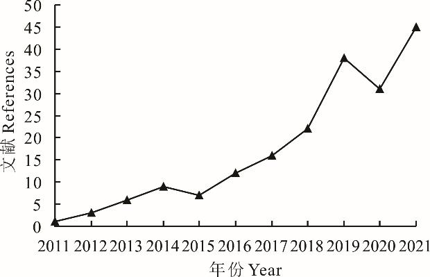
图2 Scopus平台关于无人机高光谱植被遥感的年度发文数量
Fig.2 The number of annual publications on unmanned aerial vehicle hyperspectral remote sensing of vegetation on the Scopus platform
主要遥感数据源 Major remote sensing data sources | 特点 Characteristics |
|---|---|
| 高光谱遥感Hyperspectral remote sensing | 获取光谱反射特性和空间分布特性,光谱分辨率高,覆盖波谱范围广,能够精细地描述草种波谱特性;但只能获取二维表面信息,且数据维度高,处理困难。Obtain spectral reflectance characteristics and spatial distribution characteristics, with high spectral resolution, covering a wide spectral range, and capable of finely describing the spectral characteristics of grass species; However, only two-dimensional surface information can be obtained, and the high dimensionality of the data makes processing difficult. |
| 激光雷达遥感LiDAR remote sensing | 获取垂直结构信息,穿透性好、抗干扰能力强;但受限于点云密度和高程精度,容易低估草层高度等参数。Obtain vertical structure information with good penetration and resistance to interference; However, limited by point cloud density and elevation accuracy, easy to underestimate parameters such as grass layer height. |
表1 主要遥感数据源及其特点
Table 1 Major remote sensing data sources and their characteristics
主要遥感数据源 Major remote sensing data sources | 特点 Characteristics |
|---|---|
| 高光谱遥感Hyperspectral remote sensing | 获取光谱反射特性和空间分布特性,光谱分辨率高,覆盖波谱范围广,能够精细地描述草种波谱特性;但只能获取二维表面信息,且数据维度高,处理困难。Obtain spectral reflectance characteristics and spatial distribution characteristics, with high spectral resolution, covering a wide spectral range, and capable of finely describing the spectral characteristics of grass species; However, only two-dimensional surface information can be obtained, and the high dimensionality of the data makes processing difficult. |
| 激光雷达遥感LiDAR remote sensing | 获取垂直结构信息,穿透性好、抗干扰能力强;但受限于点云密度和高程精度,容易低估草层高度等参数。Obtain vertical structure information with good penetration and resistance to interference; However, limited by point cloud density and elevation accuracy, easy to underestimate parameters such as grass layer height. |
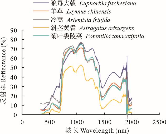
图3 草原草种的(叶片)光谱特性曲线
Fig.3 Spectral characteristic curves of grassland grass species (leaf)
项目 Item | 波谱库名称 Spectrum library name | 发布机构 Publisher | 建设年份 Construction year | 下载网址 Download site |
|---|---|---|---|---|
国外 Foreign | USGS波谱库 USGS spectrum library | 美国地质调查局 United States Geological Survey | 1993 | https://speclab.cr.usgs.gov/spectral-lib.html |
ASTER波谱库 ASTER spectrum library | 美国宇航局National Aeronautics and Space Administration | 1998 | https://speclib. Jpl.nasa.gov | |
SPECCHIO波谱库 SPECCHIO spectrum library | 苏黎世大学University of Zurich | 2003 | www.specchio/dndex.php | |
HyspIRI波谱库 HyspIRI spectrum library | 美国喷气推进实验室American Jet Propulsion Laboratory | 1999 | https: //hyspiri. jpl. nasa.gov/documents/ | |
VSL植被波谱库 VSL vegetation spectrum library | 得克萨斯大学University of Texas | 2014 | www.spectrallibrary.utep.edu | |
国内 Domestic | 地物反射光谱特性数据库 Database of reflectance spectral properties of features | 中国科学院遥感应用研究所等Institute of Remote Sensing Applications, Chinese Academy of Sciences, etc. | 20世纪90年代初 In the early 1990s | _ |
| 新疆典型荒漠植物光谱数据库Spectrum database of typical desert plants of Xinjiang | 新疆农业大学草业与环境科学学院College of Grass and Environmental Sciences, Xinjiang Agricultural University | 2013 | _ |
表2 国内外涵盖植被波谱的主要波谱库
Table 2 Major spectral libraries covering vegetation spectra at home and abroad
项目 Item | 波谱库名称 Spectrum library name | 发布机构 Publisher | 建设年份 Construction year | 下载网址 Download site |
|---|---|---|---|---|
国外 Foreign | USGS波谱库 USGS spectrum library | 美国地质调查局 United States Geological Survey | 1993 | https://speclab.cr.usgs.gov/spectral-lib.html |
ASTER波谱库 ASTER spectrum library | 美国宇航局National Aeronautics and Space Administration | 1998 | https://speclib. Jpl.nasa.gov | |
SPECCHIO波谱库 SPECCHIO spectrum library | 苏黎世大学University of Zurich | 2003 | www.specchio/dndex.php | |
HyspIRI波谱库 HyspIRI spectrum library | 美国喷气推进实验室American Jet Propulsion Laboratory | 1999 | https: //hyspiri. jpl. nasa.gov/documents/ | |
VSL植被波谱库 VSL vegetation spectrum library | 得克萨斯大学University of Texas | 2014 | www.spectrallibrary.utep.edu | |
国内 Domestic | 地物反射光谱特性数据库 Database of reflectance spectral properties of features | 中国科学院遥感应用研究所等Institute of Remote Sensing Applications, Chinese Academy of Sciences, etc. | 20世纪90年代初 In the early 1990s | _ |
| 新疆典型荒漠植物光谱数据库Spectrum database of typical desert plants of Xinjiang | 新疆农业大学草业与环境科学学院College of Grass and Environmental Sciences, Xinjiang Agricultural University | 2013 | _ |
名称 Name | 指标 Index | 定义 Definition | 特征描述 Feature description | 相关文献 Reference |
|---|---|---|---|---|
光谱位置、面积特征 Spectral position,area features | 红边Red edge | 红边幅值:一阶导曲线680~760 nm幅值;红边位置:红边幅值位置对应的波长;红边面积:680~760 nm范围内一阶导数值总和。Red edge amplitude: The first order guide curve amplitude of 680 to 760 nm. Red edge position: The wavelength corresponding to the position of the red edge amplitude. Red edge area: The sum of the first order derivativee values in the 680-760 nm range. | 对原始曲线取一阶导有助于消除土壤背景等的影响;当植被生理生化参数改变,红边位置发生“蓝移”或“红移”;红边面积可以作为红边幅值的补充。Taking a first order derivative of the original curve helps to remove the effects of soil background, etc. When the vegetation physiographic parameters change, the position of the red edge is “blue-shifted” or “red-shifted”. The area of the red edge can be used as a supplement to the red edge amplitude. | [ |
| 黄边Yellow edge | 黄边幅值:一阶导曲线560~640 nm幅值。Yellow edge amplitude: 560-640 nm amplitude of the first order guide curve. | 同上Ditto | ||
| 蓝边Blue edge | 蓝边幅值:一阶导曲线490~530 nm幅值。Blue edge amplitude: 490-530 nm amplitude of the first order guide curve. | 同上Ditto | ||
| 光谱吸收特征Spectral absorption features | 绿峰指数Green peak index | 包络线归一化曲线518~576 nm最大值。Envelope normalisation curve 518-576 nm max. | 对原始光谱曲线进行包络线归一化,放大反射峰、吸收谷,可以增加不同植被光谱差异。 The envelope normalisation of the original spectral curve, amplifying the reflection peaks and absorption valleys, can increase the differences in the spectra of different vegetation. | [ |
| 红谷指数Red valley index | 包络线归一化曲线650~692 nm最小值。Envelope normalisation curve 650-692 nm min. | |||
| 近红外峰值Near infrared peak | 原始光谱780~1000 nm最大值。 Original spectrum 780-1000 nm max. | 植被在近红外波段反射率差异大于可见光,可作为植被类型补充判据。The difference in reflectance of vegetation in the near-infrared band is greater than that of visible light and can be used as a complementary criterion for vegetation type. | [ | |
| 光谱植被指数Spectral vegetation index | 归一化差分植被指数Normalized difference vegetation index | 能够较好地响应绿色生物量的变化,对中、低密度的植被更有效。Better able to respond to changes in green biomass and more effective for medium and low density vegetation. | [ | |
| 比值植被指数Ratio vegetation index | 同上Ditto | [ | ||
| 三角植被指数Triangle vegetation index | 植被不同生长阶段叶绿素浓度改变会导致绿波段(550 nm)反射率变化,从而影响TVI。Changes in chlorophyll concentration at different stages of vegetation growth can lead to changes in the green band (550 nm) reflectance and thus affect TVI. | [ | ||
| 改进的土壤调整植被指数Improved soil adjusted vegetation index | 受土壤背景影响较小,在估计均匀冠层方面表现较好。Less influenced by soil context, better performance in estimating uniform canopy. | [ |
表3 典型植被光谱特征
Table 3 Typical vegetation spectral features
名称 Name | 指标 Index | 定义 Definition | 特征描述 Feature description | 相关文献 Reference |
|---|---|---|---|---|
光谱位置、面积特征 Spectral position,area features | 红边Red edge | 红边幅值:一阶导曲线680~760 nm幅值;红边位置:红边幅值位置对应的波长;红边面积:680~760 nm范围内一阶导数值总和。Red edge amplitude: The first order guide curve amplitude of 680 to 760 nm. Red edge position: The wavelength corresponding to the position of the red edge amplitude. Red edge area: The sum of the first order derivativee values in the 680-760 nm range. | 对原始曲线取一阶导有助于消除土壤背景等的影响;当植被生理生化参数改变,红边位置发生“蓝移”或“红移”;红边面积可以作为红边幅值的补充。Taking a first order derivative of the original curve helps to remove the effects of soil background, etc. When the vegetation physiographic parameters change, the position of the red edge is “blue-shifted” or “red-shifted”. The area of the red edge can be used as a supplement to the red edge amplitude. | [ |
| 黄边Yellow edge | 黄边幅值:一阶导曲线560~640 nm幅值。Yellow edge amplitude: 560-640 nm amplitude of the first order guide curve. | 同上Ditto | ||
| 蓝边Blue edge | 蓝边幅值:一阶导曲线490~530 nm幅值。Blue edge amplitude: 490-530 nm amplitude of the first order guide curve. | 同上Ditto | ||
| 光谱吸收特征Spectral absorption features | 绿峰指数Green peak index | 包络线归一化曲线518~576 nm最大值。Envelope normalisation curve 518-576 nm max. | 对原始光谱曲线进行包络线归一化,放大反射峰、吸收谷,可以增加不同植被光谱差异。 The envelope normalisation of the original spectral curve, amplifying the reflection peaks and absorption valleys, can increase the differences in the spectra of different vegetation. | [ |
| 红谷指数Red valley index | 包络线归一化曲线650~692 nm最小值。Envelope normalisation curve 650-692 nm min. | |||
| 近红外峰值Near infrared peak | 原始光谱780~1000 nm最大值。 Original spectrum 780-1000 nm max. | 植被在近红外波段反射率差异大于可见光,可作为植被类型补充判据。The difference in reflectance of vegetation in the near-infrared band is greater than that of visible light and can be used as a complementary criterion for vegetation type. | [ | |
| 光谱植被指数Spectral vegetation index | 归一化差分植被指数Normalized difference vegetation index | 能够较好地响应绿色生物量的变化,对中、低密度的植被更有效。Better able to respond to changes in green biomass and more effective for medium and low density vegetation. | [ | |
| 比值植被指数Ratio vegetation index | 同上Ditto | [ | ||
| 三角植被指数Triangle vegetation index | 植被不同生长阶段叶绿素浓度改变会导致绿波段(550 nm)反射率变化,从而影响TVI。Changes in chlorophyll concentration at different stages of vegetation growth can lead to changes in the green band (550 nm) reflectance and thus affect TVI. | [ | ||
| 改进的土壤调整植被指数Improved soil adjusted vegetation index | 受土壤背景影响较小,在估计均匀冠层方面表现较好。Less influenced by soil context, better performance in estimating uniform canopy. | [ |
| 定义式Definition | 特征描述Feature description |
|---|---|
| 均值Mean | |
| 方差(测量纹理异质性) Variance (measure of texture heterogeneity) | |
| 同质性Homogeneity | |
| 对比度Contrast | |
| 熵(强度影像随机性的度量) Entropy (measure of intensity image randomness) | |
| 相关性(像素与其领域的相关程度) Correlation (the degree of correlation between a pixel and its neighbourhood) | |
| 不相似性Dissimilarity | |
| 角二阶矩Asm |
表4 典型GLCM纹理特征
Table 4 Typical GLCM texture features
| 定义式Definition | 特征描述Feature description |
|---|---|
| 均值Mean | |
| 方差(测量纹理异质性) Variance (measure of texture heterogeneity) | |
| 同质性Homogeneity | |
| 对比度Contrast | |
| 熵(强度影像随机性的度量) Entropy (measure of intensity image randomness) | |
| 相关性(像素与其领域的相关程度) Correlation (the degree of correlation between a pixel and its neighbourhood) | |
| 不相似性Dissimilarity | |
| 角二阶矩Asm |
特征类型 Feature type | 特点 Characteristics |
|---|---|
| 光谱特征Spectral features | 反映草种在不同波长处的反射特性,物理意义明确,有众多可分谱段,特征提取方法多样;对草种判别具有最重要的参考意义;草种波谱库数据有待扩充。Reflects the reflectance characteristics of grass species at different wavelengths, with clear physical meaning, numerous separable spectral bands and various methods of feature extraction; The most important reference for grass species identification; Grass species spectral library data to be expanded. |
| 纹理特征Texture features | 反映草种图像的空间分布特征,是对光谱特征的有效补充。Reflects the spatial distribution of grass species images and is a useful complement to spectral features. |
| 物候特征Phenological features | 反映草种的时间变化特性,物理意义较为明确;但数据时间依赖性强,获取耗时耗力。Reflects the time-varying characteristics of grass species and has a clear physical meaning; However, the data is time-dependent and time-consuming to obtain. |
| 基于规则的特征Rule-based features | 不考虑草种自身的物理特性,自动提取遥感数据中的大量有用特征,特征提取效率高、泛化性好,在实际应用中较为可取,适用于高光谱遥感。Automatic extraction of a large number of useful features from remote sensing data without regard to the physical characteristics of the grass species itself, with high feature extraction efficiency and good generalization, which is preferable in practical applications and suitable for hyperspectral remote sensing. |
表5 特征及其应用特点
Table 5 Features and their application characteristics
特征类型 Feature type | 特点 Characteristics |
|---|---|
| 光谱特征Spectral features | 反映草种在不同波长处的反射特性,物理意义明确,有众多可分谱段,特征提取方法多样;对草种判别具有最重要的参考意义;草种波谱库数据有待扩充。Reflects the reflectance characteristics of grass species at different wavelengths, with clear physical meaning, numerous separable spectral bands and various methods of feature extraction; The most important reference for grass species identification; Grass species spectral library data to be expanded. |
| 纹理特征Texture features | 反映草种图像的空间分布特征,是对光谱特征的有效补充。Reflects the spatial distribution of grass species images and is a useful complement to spectral features. |
| 物候特征Phenological features | 反映草种的时间变化特性,物理意义较为明确;但数据时间依赖性强,获取耗时耗力。Reflects the time-varying characteristics of grass species and has a clear physical meaning; However, the data is time-dependent and time-consuming to obtain. |
| 基于规则的特征Rule-based features | 不考虑草种自身的物理特性,自动提取遥感数据中的大量有用特征,特征提取效率高、泛化性好,在实际应用中较为可取,适用于高光谱遥感。Automatic extraction of a large number of useful features from remote sensing data without regard to the physical characteristics of the grass species itself, with high feature extraction efficiency and good generalization, which is preferable in practical applications and suitable for hyperspectral remote sensing. |
遥感判别方法 Remote sensing discrimination method | 特点 Characteristics | |
|---|---|---|
| 基于纯像素假设的方法Methods based on pure pixel assumptions | 简单判别方法Simple discrimination method | 如目视判读,简单阈值法等。流程简单,但特征比较单一,可靠性差,不利于精细判别,不适合大面积草种监测。Such as visual interpretation, simple threshold method, etc. Simple process, but relatively single features, poor reliability, not conducive to fine discrimination, not suitable for monitoring grass species over large areas. |
| 机器学习/神经网络分类方法Machine learning/neural network classification methods | 如卷积网络,支持向量机等。特征自动提取,识别效率高,适合大范围草种监测,但对样本数量和质量要求很高,在精细判别方面有待深入研究。Such as convolutional networks, support vector machines, etc. Automatic feature extraction, high recognition efficiency, suitable for largescale grass species monitoring, but the number and quality of samples are very demanding, and in-depth research is needed in fine discrimination. | |
| 基于混合像素的方法Methods based on mixed pixel | 光谱混合模型Spectral mixture model | 考虑草种高度混杂情形下的判别问题,对精细判别意义重大,但草种光谱变异性问题严重,影响模型精度,相关研究最少。Consideration of discrimination in highly mixed grass species situations is of great significance for fine discrimination, but the problem of spectral variability of grass species is serious and affects the accuracy of the model, with minimal relevant studies. |
表6 遥感判别方法及其主要特点
Table 6 Remote sensing discrimination methods and their main characteristics
遥感判别方法 Remote sensing discrimination method | 特点 Characteristics | |
|---|---|---|
| 基于纯像素假设的方法Methods based on pure pixel assumptions | 简单判别方法Simple discrimination method | 如目视判读,简单阈值法等。流程简单,但特征比较单一,可靠性差,不利于精细判别,不适合大面积草种监测。Such as visual interpretation, simple threshold method, etc. Simple process, but relatively single features, poor reliability, not conducive to fine discrimination, not suitable for monitoring grass species over large areas. |
| 机器学习/神经网络分类方法Machine learning/neural network classification methods | 如卷积网络,支持向量机等。特征自动提取,识别效率高,适合大范围草种监测,但对样本数量和质量要求很高,在精细判别方面有待深入研究。Such as convolutional networks, support vector machines, etc. Automatic feature extraction, high recognition efficiency, suitable for largescale grass species monitoring, but the number and quality of samples are very demanding, and in-depth research is needed in fine discrimination. | |
| 基于混合像素的方法Methods based on mixed pixel | 光谱混合模型Spectral mixture model | 考虑草种高度混杂情形下的判别问题,对精细判别意义重大,但草种光谱变异性问题严重,影响模型精度,相关研究最少。Consideration of discrimination in highly mixed grass species situations is of great significance for fine discrimination, but the problem of spectral variability of grass species is serious and affects the accuracy of the model, with minimal relevant studies. |
| 1 | Department of Animal Husbandry and Veterinary Medicine, Ministry of Agriculture of the People’s Republic of China, National animal husbandry and veterinary station. Grassland resources in China. Beijing: China Science and Technology Press, 1996. |
| 中华人民共和国农业部畜牧兽医司, 全国畜牧兽医总站. 中国草地资源. 北京: 中国科学技术出版社, 1996. | |
| 2 | Wang W, Liang C Z, Liu Z L, et al. Research on restoring succession of degenerated grassland in Inner Mongolia Ⅳ. Analysis Of plant population dynamics during restoring succession. Journal of Arid Land Resources and Environment, 1999, 13(4): 44-55. |
| 王炜, 梁存柱, 刘钟龄, 等. 内蒙古草原退化群落恢复演替的研究Ⅳ. 恢复演替过程中植物种群动态的分析. 干旱区资源与环境, 1999, 13(4): 44-55. | |
| 3 | Li Y H. Research on the grazing degradation model of the main steppe rangelands in Inner Mongolia and some considerations for the establishment of a computerized rangeland monitoring system. Chinese Journal of Plant Ecology, 1994, 18(1): 68-79. |
| 李永宏. 内蒙古草原草场放牧退化模式研究及退化监测专家系统雏议. 植物生态学报, 1994, 18(1): 68-79. | |
| 4 | Richardson A J, Escobar D E, Gausman H W, et al. Use of LANDSAT-2 data technique to estimate silver leaf sunflower infestation//7th International Symposium-Machine Processing of Remotely Sensed Data with Special Emphasis on Range, Forest and Wetlands Assessment. W Lafayette, IN, USA: American Society of Agronomy, 1981: 676-683. |
| 5 | Peters A J, Reed B C, Eve M D, et al. Remote-sensing of broom sake weed (Gutierrezia-Sarothrae) with NOAA-10 spectral image-processing. Weed Technology, 1992, 6(4): 1015-1020. |
| 6 | Xu D D, Guo X L. Some insights on grassland health assessment based on remote sensing. Sensors, 2015, 15(2): 3070-3089. |
| 7 | Zhang M, Qian Y R, Du J, et al. A grassland classification algorithm using convolutional neural network based on feature integration. Computer Engineering and Science, 2019, 41(7): 1251-1256. |
| 张猛, 钱育蓉, 杜娇, 等. 基于特征整合的卷积神经网络草地分类算法. 计算机工程与科学, 2019, 41(7): 1251-1256. | |
| 8 | Yang H Y, Du J M, Wang Y, et al. Classification method of grassland species based on unmanned aerial vehicle remote sensing and convolutional neural network. Transactions of the Chinese Society for Agricultural Machinery, 2019, 50(4): 188-195. |
| 杨红艳, 杜健民, 王圆, 等. 基于无人机遥感与卷积神经网络的草原物种分类方法. 农业机械学报, 2019, 50(4): 188-195. | |
| 9 | Zhang X P, Bi Y G, Yang H Y, et al. Classification model of dominant species in desertification grassland based on hyperspectral remote sensing. Optical Technique, 2020, 46(4): 483-488. |
| 张锡鹏, 毕玉革, 杨红艳, 等. 基于高光谱遥感的荒漠化草原草种类分类模型研究. 光学技术, 2020, 46(4): 483-488. | |
| 10 | Qian J B, Ma M G. A review of poisonous weeds detection using remote sensing technology. Remote Sensing Technology and Application, 2009, 24(5): 685-690. |
| 钱金波, 马明国. 遥感技术在毒草识别中的研究进展. 遥感技术与应用, 2009, 24(5): 685-690. | |
| 11 | Schmidt K S, Skidmore A K. Spectral discrimination of vegetation types in a coastal wetland. Remote Sensing of Environment, 2003, 85(1): 92-108. |
| 12 | Goetz A F H. Three decades of hyperspectral remote sensing of the earth: A personal view. Remote Sensing of Environment, 2009, 113: S5-S16. |
| 13 | Bioucas-Dias J M, Plaza A, Camps-Valls G, et al. Hyperspectral remote sensing data analysis and future challenges. IEEE Geoscience and Remote Sensing Magazine, 2013, 1(2): 6-36. |
| 14 | Zhao X H, Pan X, Yan W H, et al. Research on grassland forage hyperspectral image recognition based on variance selection and gaussian naive bayes. Journal of Optoelectronics·Laser, 2020, 31(7): 688-695. |
| 赵烜赫, 潘新, 闫伟红, 等. 基于方差选择和高斯朴素贝叶斯的草地牧草高光谱图像识别研究. 光电子·激光, 2020, 31(7): 688-695. | |
| 15 | Hu Y N, An R, Ai Z T, et al. Researches on grass species fine identification based on UAV hyperspectral images in Three-river Source region. Remote Sensing Technology and Application, 2021, 36(4): 926-935. |
| 胡宜娜, 安如, 艾泽天, 等. 基于无人机高光谱影像的三江源草种精细识别研究. 遥感技术与应用, 2021, 36(4): 926-935. | |
| 16 | Han D, Wang J L, Wen J, et al. Study on identification for the typical pasture based on image texture features//Proceedings of the 31st Chinese Control and Decision Conference (CCDC). Nanchang, China: Northeastern University State Key Laboratory of Synthetical Automation for Process Industries, 2019: 778-782. |
| 17 | Liu H, Du J M, Pi W Q, et al. Identification and classification of desert grassland species based on A-Clenet5. Journal of Optoelectronics·Laser, 2019, 30(10): 1056-1061. |
| 刘浩, 杜建民, 皮伟强, 等. 基于A-Clenet5的荒漠化草原草种识别与分类. 光电子·激光, 2019, 30(10): 1056-1061. | |
| 18 | Cooper S D, Roy D P, Schaaf C B, et al. Examination of the potential of terrestrial laser scanning and structure-from-motion photogrammetry for rapid nondestructive field measurement of grass biomass. Remote Sensing, 2017, 9(6): 531. |
| 19 | Xu K X, Su Y J, Liu J, et al. Estimation of degraded grassland aboveground biomass using machine learning methods from terrestrial laser scanning data. Ecological Indicators, 2020, 108: 105747. |
| 20 | Guo P, Wu F D, Dai J G, et al. Estimation of vegetation height in farmland region based on airborne LiDAR data. Arid Land Geography, 2017, 40(6): 1241-1247. |
| 郭鹏, 武法东, 戴建国, 等. 基于机载LiDAR数据的农田区植被高度估测研究. 干旱区地理, 2017, 40(6): 1241-1247. | |
| 21 | Streutker D R, Glenn N F. LiDAR measurement of sagebrush steppe vegetation heights. Remote Sensing of Environment, 2006, 102(1/2): 135-145. |
| 22 | Mitchell J J, Glenn N F, Sankey T T, et al. Small-footprint LiDAR estimations of sagebrush canopy characteristics. Photogrammetric Engineering and Remote Sensing, 2011, 77(5): 521-530. |
| 23 | Fan L, Powrie W, Smethurst J, et al. The effect of short ground vegetation on terrestrial laser scans at a local scale. Isprs Journal of Photogrammetry and Remote Sensing, 2014, 95: 42-52. |
| 24 | Olsoy P J, Glenn N F, Clark P E, et al. Aboveground total and green biomass of dryland shrub derived from terrestrial laser scanning. Isprs Journal of Photogrammetry and Remote Sensing, 2014, 88: 166-173. |
| 25 | Zlinszky A, Schroiff A, Kania A, et al. Categorizing grassland vegetation with full-waveform airborne laser scanning: A feasibility study for detecting natura 2000 habitat types. Remote Sensing, 2014, 6(9): 8056-8087. |
| 26 | Moeslund J E, Zlinszky A, Ejrnaes R, et al. Light detection and ranging explains diversity of plants, fungi, lichens, and bryophytes across multiple habitats and large geographic extent. Ecological Applications, 2019, 29(5): e01907. |
| 27 | Orka H O, Naesset E, Bollandsas O M. Classifying species of individual trees by intensity and structure features derived from airborne laser scanner data. Remote Sensing of Environment, 2009, 113(6): 1163-1174. |
| 28 | Liu L, Coops N C, Aven N W, et al. Mapping urban tree species using integrated airborne hyperspectral and LiDAR remote sensing data. Remote Sensing of Environment, 2017, 200: 170-182. |
| 29 | Li Y M, Guo Q H, Wan B, et al. Current status and prospect of three-dimensional dynamic monitoring of natural resources based on LiDAR. National Remote Sensing Bulletin, 2021, 25(1): 381-402. |
| 李玉美, 郭庆华, 万波, 等. 基于激光雷达的自然资源三维动态监测现状与展望. 遥感学报, 2021, 25(1): 381-402. | |
| 30 | Hopkinson C, Chasmer L E, Sass G, et al. Vegetation class dependent errors in lidar ground elevation and canopy height estimates in a boreal wetland environment. Canadian Journal of Remote Sensing, 2005, 31(2): 191-206. |
| 31 | Glenn N F, Spaete L P, Sankey T T, et al. Errors in LiDAR-derived shrub height and crown area on sloped terrain. Journal of Arid Environments, 2011, 75(4): 377-382. |
| 32 | Rasti B, Ghamisi P, Gloaguen R. Hyperspectral and LiDAR fusion using extinction profiles and total variation component analysis. IEEE Transactions on Geoscience and Remote Sensing, 2017, 55(7): 3997-4007. |
| 33 | Jones T G, Coops N C, Sharma T. Assessing the utility of airborne hyperspectral and LiDAR data for species distribution mapping in the coastal Pacific Northwest, Canada. Remote Sensing of Environment, 2010, 114(12): 2841-2852. |
| 34 | Dalponte M, Bruzzone L, Gianelle D. Fusion of hyperspectral and LiDAR remote sensing data for classification of complex forest areas. IEEE Transactions on Geoscience and Remote Sensing, 2008, 46(5): 1416-1427. |
| 35 | Alonzo M, Bookhagen B, Roberts D A. Urban tree species mapping using hyperspectral and LiDAR data fusion. Remote Sensing of Environment, 2014, 148: 70-83. |
| 36 | Liu X L, Bo Y C. Object-based crop species classification based on the combination of airborne hyperspectral images and LiDAR data. Remote Sensing, 2015, 7(1): 922-950. |
| 37 | Zhang L P, Shen H F. Progress and future of remote sensing data fusion. Journal of Remote Sensing, 2016, 20(5): 1050-1061. |
| 张良培, 沈焕锋. 遥感数据融合的进展与前瞻. 遥感学报, 2016, 20(5): 1050-1061. | |
| 38 | Xu X R. Remote sensing physics. Beijing: Peking University Press, 2005. |
| 徐希孺. 遥感物理. 北京: 北京大学出版社, 2005. | |
| 39 | Zhao Y S. Remote sensing applications and analysis: Principles and methods. Beijing: Science Press, 2003. |
| 赵英时. 遥感应用分析原理与方法. 北京: 科学出版社, 2003. | |
| 40 | Kokaly R F, Clark R N, Swayze G A, et al. USGS spectral library version 7. 2017. https: //doi. org/10. 3133/ds1035. |
| 41 | Baldridge A M, Hook S J, Grove C I, et al. The ASTER spectral library version 2.0. Remote Sensing of Environment, 2009, 113(4): 711-715. |
| 42 | Hueni A, Nieke J, Schopfer J, et al. The spectral database SPECCHIO for improved long-term usability and data sharing. Computers&Geosciences, 2009, 35(3): 557-565. |
| 43 | Green R O. HyspIRI ecosystem spectral library. [2015-03-06]. https://hyspiri. jpl. nasa. gov/documents/. |
| 44 | Tian Q J, Gong P. Review on spectral libraries: Research status and development trend. Remote Sensing Information, 2002(3): 2-6, 46. |
| 田庆久, 宫鹏. 地物波谱数据库研究现状与发展趋势. 遥感信息, 2002(3): 2-6, 46. | |
| 45 | Li S P, Li X, Huang X Z, et al. Spectrum database construction of typical desert plants in Xinjiang. Xinjiang Agricultural Sciences, 2013, 50(6): 1128-1136. |
| 李少鹏, 李霞, 黄祥志, 等. 新疆典型荒漠植物光谱数据库构建. 新疆农业科学, 2013, 50(6): 1128-1136. | |
| 46 | Zhou W, Li H R, Shi P Q, et al. Spectral characteristics of vegetation of poisonous weed degraded grassland in the “Three-River Headwaters” region. Journal of Geo-information Science, 2020, 22(8): 1735-1742. |
| 周伟, 李浩然, 石佩琪, 等. 三江源区毒杂草型退化草地植被光谱特征分析. 地球信息科学学报, 2020, 22(8): 1735-1742. | |
| 47 | Pu R, Gong P. Hyperspectral remote sensing of vegetation bioparameters. Boca Raton, USA: CRC Press-Taylor&Francis Group, 2011: 101-142. |
| 48 | Tong Q X, Zhang B, Zheng L F. Hyperspectral remote sensing: Principle, technology and application. Beijing: Higher Education Press, 2006. |
| 童庆禧, 张兵, 郑兰芬. 高光谱遥感原理、技术与应用. 北京: 高等教育出版社, 2006. | |
| 49 | Gong P, Pu R, Yu B. Conifer species recognition: An exploratory analysis of in situ hyperspectral data. Remote Sensing of Environment, 1997, 62(2): 188-200. |
| 50 | Pu R L. Broadleaf species recognition with in situ hyperspectral data. International Journal of Remote Sensing, 2009, 30(11): 2759-2779. |
| 51 | Wang C, Zhou B, Palm H L. Detecting invasive sericea lespedeza (Lespedeza cuneata) in mid-missouri pastureland using hyperspectral imagery. Environmental Management, 2008, 41(6): 853-862. |
| 52 | An R, Jiang D P, Li X X, et al. Using hyperspectral data to determine spectral characteristics of grassland vegetation in central and eastern parts of Three-River Source. Remote Sensing Technology and Application, 2014, 29(2): 202-211. |
| 安如, 姜丹萍, 李晓雪, 等. 基于地面实测高光谱数据的三江源中东部草地植被光谱特征研究. 遥感技术与应用, 2014, 29(2): 202-211. | |
| 53 | Li X H, Wang H, Li X B, et al. Identifying degraded grass species in Inner Mongolia based on measured hyperspectral data. IEEE Journal of Selected Topics in Applied Earth Observations and Remote Sensing, 2019, 12(12): 5061-5075. |
| 54 | Clark R N, Roush T L. Reflectance spectroscopy-quantitative-analysis techniques for remote-sensing applications. Journal of Geophysical Research, 1984, 89(NB7): 6329-6340. |
| 55 | Galvao L S, Formaggio A R, Tisot D A. Discrimination of sugarcane varieties in southeastern brazil with EO-1 hyperion data. Remote Sensing of Environment, 2005, 94(4): 523-534. |
| 56 | Feng S S, Tian B, Hu Y C, et al. The hyper-spectra characteristics of degradation indicator species in the grassland of Bashang region. Journal of Arid Land Resources and Environment, 2016, 30(3): 133-139. |
| 冯双双, 田冰, 胡引翠, 等. 坝上草原退化指示种光谱特征研究. 干旱区资源与环境, 2016, 30(3): 133-139. | |
| 57 | Hao F F, Chen Y M, Gao J X, et al. Identification of hyperspectra characteristic bands of grassland degradation indicator plant species in Bashang region of Hebei Province. Journal of Ecology and Rural Environment, 2016, 32(6): 1024-1029. |
| 郝芳芳, 陈艳梅, 高吉喜, 等. 河北坝上地区草地退化指示种的高光谱特征波段识别. 生态与农村环境学报, 2016, 32(6): 1024-1029. | |
| 58 | Pu R. Hyperspectral remote sensing: Fundamentals and practices. Boca Raton, USA: Crc Press-Taylor&Francis Group, 2017. |
| 59 | Asner G P, Martin R E, Carlson K M, et al. Vegetation-climate interactions among native and invasive species in Hawaiian rainforest. Ecosystems, 2006, 9(7): 1106-1117. |
| 60 | Lu B, He Y. Species classification using unmanned aerial vehicle (UAV)-acquired high spatial resolution imagery in a heterogeneous grassland. ISPRS Journal of Photogrammetry and Remote Sensing, 2017, 128: 73-85. |
| 61 | Mallinis G, Koutsias N, Tsakiri-Strati M, et al. Object-based classification using Quickbird imagery for delineating forest vegetation polygons in a Mediterranean test site. ISPRS Journal of Photogrammetry and Remote Sensing, 2008, 63(2): 237-250. |
| 62 | Mei A X, Peng W L, Qin Q M, et al. Introduction to remote sensing. Beijing: Higher Education Press, 2001. |
| 梅安新, 彭望绿, 秦其明, 等. 遥感导论. 北京: 高等教育出版社, 2001. | |
| 63 | Haralick R M, Shanmugam K, Dinstein I. Textural features for image classification. IEEE Transactions on Systems, Man, and Cybernetics, 1973, SMC3(6): 610-621. |
| 64 | Pentland A P. Fractal-based description of natural scenes. IEEE Transactions on Pattern Analysis and Machine Intelligence, 1984, 6(6): 661-674. |
| 65 | Mallat S G. A theory for multiresolution signal decomposition: The wavelet representation. IEEE Transactions on Pattern Analysis and Machine Intelligence, 1989, 11(7): 674-693. |
| 66 | Bo H, Ma F L, Jiao L C. Research on computation of GLCM of image texture. Acta Electron Sinica, 2006, 34(1): 134, 155-158. |
| 薄华, 马缚龙, 焦李成. 图像纹理的灰度共生矩阵计算问题的分析. 电子学报, 2006, 34(1): 134, 155-158. | |
| 67 | Rouse J W, Haas R H, Schell J A, et al. Monitoring vegetation systems in the Great Plains with ERTS. Proceedings, Third ERTS Symposium, 1973, 1: 48-62. |
| 68 | Broge N H, Leblanc E. Comparing prediction power and stability of broadband and hyperspectral vegetation indices for estimation of green leaf area index and canopy chlorophyll density. Remote Sensing of Environment, 2001, 76(2): 156-172. |
| 69 | Baret F, Guyot G. Potentials and limit of vegetation indexes for LAI and APAR assessment. Remote Sensing of Environment, 1991, 35(2/3): 161-173. |
| 70 | Chen D, Stow D A, Gong P. Examining the effect of spatial resolution and texture window size on classification accuracy: An urban environment case. International Journal of Remote Sensing, 2004, 25(11): 2177-2192. |
| 71 | Lu P L, Yu Q, He Q T. Responses of plant phenology to climatic change. Acta Ecologica Sinica, 2006(3): 923-929. |
| 陆佩玲, 于强, 贺庆棠. 植物物候对气候变化的响应. 生态学报, 2006(3): 923-929. | |
| 72 | Wang M. Research on sugarcane field recognition method based on support vector machine. Guilin: Guangxi Normal University, 2020. |
| 王明. 基于支持向量机的甘蔗田识别方法研究. 桂林: 广西师范大学, 2020. | |
| 73 | Nagol J R, Sexton J O, Anand A, et al. Isolating type-specific phenologies through spectral unmixing of satellite time series. International Journal of Digital Earth, 2018, 11(3): 233-245. |
| 74 | Zhang F, Wu B F, Liu C L, et al. Methods of monitoring crop phonological stages using time series of vegetation indicator. Transactions of the Chinese Society of Agricultural Engineering, 2004(1): 155-159. |
| 张峰, 吴炳方, 刘成林, 等. 利用时序植被指数监测作物物候的方法研究. 农业工程学报, 2004(1): 155-159. | |
| 75 | Reed B C, Brown J F, Vanderzee D, et al. Measuring phenological variability from satellite imagery. Journal of Vegetation Science, 1994, 5(5): 703-714. |
| 76 | Jonsson P, Eklundh L. Seasonality extraction by function fitting to time-series of satellite sensor data. IEEE Transactions on Geoscience and Remote Sensing, 2002, 40(8): 1824-1832. |
| 77 | Diallo O, Diouf A, Hanan N P, et al. AVHRR monitoring of savanna primary production in Senegal, West Africa-1987-1988. International Journal of Remote Sensing, 1991, 12(6): 1259-1279. |
| 78 | Prince S D. Satellite remote-sensing of primary production-comparison of results for Sahelian grasslands 1981-1988. International Journal of Remote Sensing, 1991, 12(6): 1301-1311. |
| 79 | Wei L F, Yu M, Zhong Y F, et al. Spatial-spectral fusion based on conditional random fields for the fine classification of crops in UAV-borne hyperspectral remote sensing imagery. Remote Sensing, 2019, 11(7): 780. |
| 80 | Gausman H W, Menges R M, Escobar D E, et al. Pubescence affects spectra and imagery of silverleaf sunflower (Helianthus argophyllus). Weed Science, 1977, 25(5): 437-440. |
| 81 | Everitt J H, Escobar D E, Davis M R. Reflectance and image characteristics of selected noxious rangeland species. Journal of Range Management, 2001, 54: A106-A120. |
| 82 | Lass L W, Callihan R H. The effect of phenological stage on detectability of yellow hawkweed (Hieracium pratense) and oxeye daisy (Chrysanthemum leucanthemum) with remote multispectral digital imagery. Weed Technology, 1997, 11(2): 248-256. |
| 83 | Pan X, Liu G X, Yan W H, et al. Grass recognition based on Gabor energy featuress computer engineering and applications. Journal of Inner Mongolia Agricultural University, 2012, 33(5/6): 211-214. |
| 潘新, 刘桂香, 闫伟红, 等. 基于Gabor能量特征的牧草识别. 内蒙古农业大学学报, 2012, 33(5/6): 211-214. | |
| 84 | Van Der Meer F, De Jong S, Bakker W. Imaging spectrometry: Basic analytical techniques. Imaging Spectrometry: Basic Principles and Prospective Applications, 2001, 4: 17-61. |
| 85 | Fan F L. The application and evaluation of two methods based on LSMM model-A case study in Guangzhou. Remote Sensing Technology and Application, 2008, 23(3): 239-240, 272-277. |
| 樊风雷. 基于线性光谱混合模型(LSMM)的两种不同端元值选取方法应用与评价——以广州市为例. 遥感技术与应用, 2008, 23(3): 239-240, 272-277. | |
| 86 | Qi J C, Zhu S L, Zhu B S, et al. Research on automated end member extraction algorithm. Hydrographic Surveying and Charting, 2009, 29(2): 16-19. |
| 齐建成, 朱述龙, 朱宝山, 等. 图像端元全自动提取方法研究. 海洋测绘, 2009, 29(2): 16-19. | |
| 87 | Gunes E, Yuksel S E. Effect of endmember clustering on proportion estimation: Results on the Share 2012 dataset//Proceedings of the Conference on Algorithms and Technologies for Multispectral, Hyperspectral, and Ultraspectral Imagery XXI. Baltimore, MD, US: SPIE, 2015. |
| 88 | Adams J B, Smith M O, Gillespie A R. Simple models for complex natural surfaces: A strategy for the hyperspectral era of remote sensing. Digest-International Geoscience and Remote Sensing Symposium (IGARSS), 1989, 1: 16-21. |
| 89 | Heinz D C, Chang C I. Fully constrained least squares linear spectral mixture analysis method for material quantification in hyperspectral imagery. IEEE Transactions on Geoscience and Remote Sensing, 2001, 39(3): 529-545. |
| 90 | Chang C I, Ren H, Chang C C, et al. Estimation of subpixel target size for remotely sensed imagery. IEEE Transactions on Geoscience and Remote Sensing, 2004, 42(6): 1309-1320. |
| 91 | Rajabi R, Ghassemian H. Spectral unmixing of hyperspectral imagery using multilayer NMF. IEEE Geoscience and Remote Sensing Letters, 2015, 12(1): 38-42. |
| 92 | Li X Y, Xiao J N, Yu J J. Long-distance wireless mm-wave signal delivery at w-band. Journal of Lightwave Technology, 2016, 34(2): 661-668. |
| 93 | Zhang L P, Li J Y. Development and prospect of sparse representation-based hyperspectral image processing and analysis. Journal of Remote Sensing, 2016, 20(5): 1091-1101. |
| 张良培, 李家艺. 高光谱图像稀疏信息处理综述与展望. 遥感学报, 2016, 20(5): 1091-1101. | |
| 94 | Iordache M D, Bioucas-dias J M, Plaza A. Sparse unmixing of hyperspectral data. IEEE Transactions on Geoscience and Remote Sensing, 2011, 49(6): 2014-2039. |
| 95 | Jia S, Qian Y T. Constrained nonnegative matrix factorization for hyperspectral unmixing. IEEE Transactions on Geoscience and Remote Sensing, 2009, 47(1): 161-173. |
| 96 | Liu J J, Wu Z B, Wei Z H, et al. A novel sparsity constrained nonnegative matrix factorization for hyperspectral unmixing// Proceedings of the IEEE International Geoscience and Remote Sensing Symposium (IGARSS). Munich, Germany: Geoscience and Remote Sensing Society, 2012: 1389-1392. |
| 97 | Wang H J, Zhou L, Yan B Y, et al. The identification of indicator grass species of grassland degradation based on the field spectral characteristics//Proceedings of the IEEE International Geoscience and Remote Sensing Symposium. Cape Town, South Africa: Geoscience and Remote Sensing Society, 2009, 3: 455-458. |
| 98 | Gai Y Y, Fan W J, Xu X R, et al. Flower species identification and coverage estimation based on hyperspectral remote sensing data//Proceedings of the IEEE International Geoscience and Remote Sensing Symposium (IGARSS). Vancouver, BC, Canada: IEEE GRSS, 2011: 1243-1246. |
| 99 | Judd C, Steinberg S, Shaughnessy F, et al. Mapping salt marsh vegetation using aerial hyperspectral imagery and linear unmixing in Humboldt bay, California. Wetlands, 2007, 27(4): 1144-1152. |
| 100 | Zhang C S, Ma L, Chen J, et al. Assessing the impact of endmember variability on linear spectral mixture analysis (LSMA): A theoretical and simulation analysis. Remote Sensing of Environment, 2019, 235: 111471. |
| 101 | Roberts D A, Gardner M, Church R, et al. Mapping chaparral in the Santa Monica Mountains using multiple endmember spectral mixture models. Remote Sensing of Environment, 1998, 65(3): 267-279. |
| 102 | Somers B, Delalieux S, Stuckens J, et al. A weighted linear spectral mixture analysis approach to address endmember variability in agricultural production systems. International Journal of Remote Sensing, 2009, 30(1): 139-147. |
| 103 | Somers B, Delalieux S, Verstraeten W W, et al. An automated waveband selection technique for optimized hyperspectral mixture analysis. International Journal of Remote Sensing, 2010, 31(20): 5549-5568. |
| 104 | Yuan J, Zhang Y J, Gao F P. An overview on linear hyperspectral unmixing. Journal of Infrared and Millimeter Waves, 2018, 37(5): 553-571. |
| 袁静, 章毓晋, 高方平. 线性高光谱解混模型综述. 红外与毫米波学报, 2018, 37(5): 553-571. |
| [1] | 许开宏, 施招, 马磊超, 王平, 陈昂, 王兴, 成明, 肖粤新, 王荣谭. 基于机载激光雷达与高景一号数据的草原地上生物量反演研究[J]. 草业学报, 2023, 32(5): 40-49. |
| [2] | 修炀景, 侯蒙京, 田骄阳, 梁天刚, 冯琦胜. 基于土地利用/覆盖的甘肃省景观生态风险时空变化特征[J]. 草业学报, 2023, 32(1): 1-15. |
| [3] | 花蕊, 周睿, 包达尔罕, 董克池, 唐庄生, 花立民. 基于旋翼无人机低空遥感的高原鼠兔危害等级划分技术研究[J]. 草业学报, 2022, 31(4): 165-176. |
| [4] | 张仁平, 郭靖, 马晓芳, 郭伟勇. 基于MODIS数据的新疆草地物候提取方法及变化趋势分析[J]. 草业学报, 2022, 31(1): 1-12. |
| [5] | 林慧龙, 蒲彦妃, 王丹妮, 马海丽. 草原指数保险:评述与中国方案设计[J]. 草业学报, 2021, 30(8): 171-185. |
| [6] | 张亦然, 刘廷玺, 童新, 段利民, 吴宇辰. 基于XGBoost算法的草甸地上生物量的高光谱遥感反演[J]. 草业学报, 2021, 30(4): 1-12. |
| [7] | 张殿岱, 王雪梅, 昝梅. 基于Landsat 8 OLI影像的渭-库绿洲植被地上生物量估算[J]. 草业学报, 2021, 30(11): 1-12. |
| [8] | 高金龙, 刘洁, 殷建鹏, 葛静, 侯蒙京, 冯琦胜, 梁天刚. 天然草地牧草营养品质的高光谱遥感研究进展[J]. 草业学报, 2020, 29(2): 172-185. |
| [9] | 赵慧芳, 李晓东, 张东, 校瑞香. 基于MODIS数据的青海省草地地上生物量估算及影响因素研究[J]. 草业学报, 2020, 29(12): 5-16. |
| [10] | 侯蒙京, 高金龙, 葛静, 李元春, 刘洁, 殷建鹏, 冯琦胜, 梁天刚. 青藏高原东部高寒沼泽湿地动态变化及其驱动因素研究[J]. 草业学报, 2020, 29(1): 13-27. |
| [11] | 杨帆, 邵全琴, 郭兴健, 李愈哲, 王东亮, 张雅娴, 汪阳春, 刘纪远, 樊江文. 玛多县大型野生食草动物种群数量对草畜平衡的影响研究[J]. 草业学报, 2018, 27(7): 1-13. |
| [12] | 张永, 杨自辉, 郭树江, 王强强, 詹科杰, 张剑挥, 魏怀东. 基于遥感分析20年来民勤绿洲防护林带植被变化研究[J]. 草业学报, 2018, 27(7): 14-24. |
| [13] | 荀其蕾,董乙强,安沙舟,闫凯. 基于MOD 09GA数据的新疆草地生长状况遥感监测研究[J]. 草业学报, 2018, 27(4): 10-26. |
| [14] | 史莎娜, 汤传勇, 谢炳庚, 刘敏, 覃畅文. 喀斯特山地草地资源遥感调查及常态化监测研究——以灌阳县为例[J]. 草业学报, 2018, 27(1): 14-21. |
| [15] | 王梦佳, 孙睿, 刘喆, 辛晓平, 刘刚, 张蕾, 乔晨. 基于遥感数据的呼伦贝尔草原放牧强度研究[J]. 草业学报, 2017, 26(6): 28-36. |
| 阅读次数 | ||||||
|
全文 |
|
|||||
|
摘要 |
|
|||||