
ISSN 1004-5759 CN 62-1105/S
Acta Prataculturae Sinica ›› 2022, Vol. 31 ›› Issue (6): 23-34.DOI: 10.11686/cyxb2021180
Previous Articles Next Articles
Yu-zhuo ZHANG1( ), Zhi-gui YANG1, Hong-yan YU2, Qiang ZHANG3, Shu-xia YANG3, Ting ZHAO1, Hua-hua XU1, Bao-ping MENG1(), Yan-yan LV1
Received:2021-05-07
Revised:2021-06-21
Online:2022-06-20
Published:2022-05-11
Contact:
Bao-ping MENG
Yu-zhuo ZHANG, Zhi-gui YANG, Hong-yan YU, Qiang ZHANG, Shu-xia YANG, Ting ZHAO, Hua-hua XU, Bao-ping MENG, Yan-yan LV. Estimating grassland above ground biomass based on the STARFM algorithm and remote sensing data——A case study in the Sangke grassland in Xiahe County, Gansu Province[J]. Acta Prataculturae Sinica, 2022, 31(6): 23-34.

Fig.1 Overview of the study area
MODIS影像日期 Date of MODIS image | Landsat影像日期 Date of Landsat image | 采样时间 Sampling time | 样地数 Number of plots | 样方数 Number of samples |
|---|---|---|---|---|
| 2013-08-13 | 2013-08-08 | 2013-08-08 | 11 | 55 |
| 2014-07-28 | 2014-07-26 | 2014-07-28 | 13 | 65 |
| 2015-07-12 | 2015-07-13 | 2015-07-13 | 13 | 65 |
| 2016-07-27 | 2016-07-31 | 2016-07-26 | 11 | 55 |
Table 1 Date remote sensing image and field survey
MODIS影像日期 Date of MODIS image | Landsat影像日期 Date of Landsat image | 采样时间 Sampling time | 样地数 Number of plots | 样方数 Number of samples |
|---|---|---|---|---|
| 2013-08-13 | 2013-08-08 | 2013-08-08 | 11 | 55 |
| 2014-07-28 | 2014-07-26 | 2014-07-28 | 13 | 65 |
| 2015-07-12 | 2015-07-13 | 2015-07-13 | 13 | 65 |
| 2016-07-27 | 2016-07-31 | 2016-07-26 | 11 | 55 |
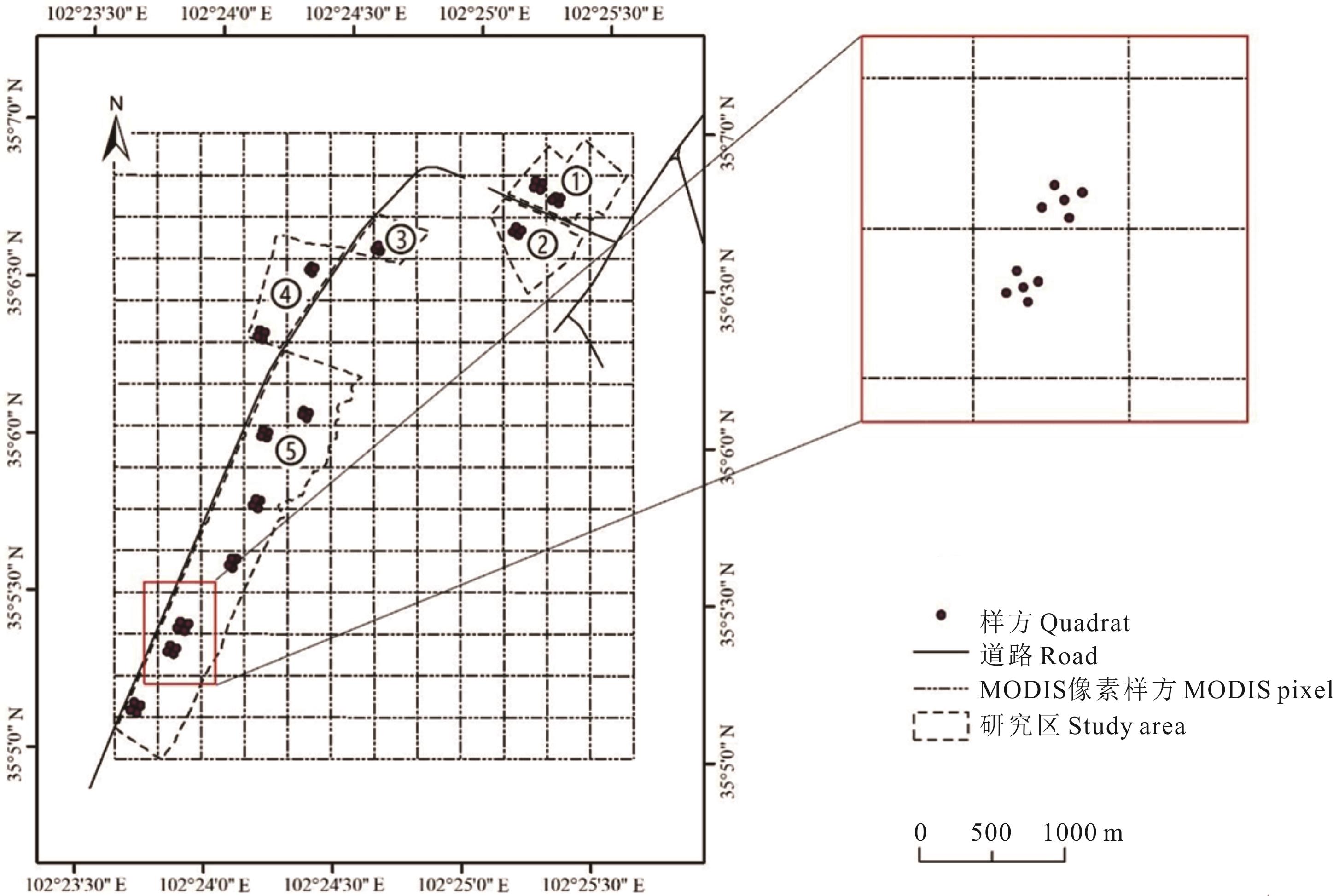
Fig.2 Distribution of sample sites in the study area

Fig.3 MODIS and Landsat image data
| 植被指数和生物量Vegetation index and biomass | 最大值Max | 最小值Min | 平均值Mean | 标准偏差STD | 变异系数CV |
|---|---|---|---|---|---|
| NDVIMODIS | 0.84 | 0.58 | 0.74 | 0.08 | 0.15 |
| NDVILandsat | 0.91 | 0.55 | 0.77 | 0.10 | 0.13 |
| NDVISTARFM | 0.95 | 0.47 | 0.72 | 0.11 | 0.17 |
| 生物量Biomass (kg·hm-2) | 3997.33 | 745.52 | 2299.30 | 972.60 | 0.42 |
Table 2 Statistical description of vegetation index and grassland biomass in the study area
| 植被指数和生物量Vegetation index and biomass | 最大值Max | 最小值Min | 平均值Mean | 标准偏差STD | 变异系数CV |
|---|---|---|---|---|---|
| NDVIMODIS | 0.84 | 0.58 | 0.74 | 0.08 | 0.15 |
| NDVILandsat | 0.91 | 0.55 | 0.77 | 0.10 | 0.13 |
| NDVISTARFM | 0.95 | 0.47 | 0.72 | 0.11 | 0.17 |
| 生物量Biomass (kg·hm-2) | 3997.33 | 745.52 | 2299.30 | 972.60 | 0.42 |
植被指数 Vegetation index | 线性Linear | 对数Logarithmic | 乘幂Power | 指数Exponential | ||||
|---|---|---|---|---|---|---|---|---|
| R2 | RMSE | R2 | RMSE | R2 | RMSE | R2 | RMSE | |
| NDVIMODIS | 0.17 | 917.21 | 0.17 | 916.80 | 0.24 | 937.79 | 0.24 | 940.72 |
| NDVILandsat | 0.65 | 586.72 | 0.66 | 576.76 | 0.76 | 634.83 | 0.75 | 665.32 |
| NDVISTARFM | 0.49 | 714.93 | 0.52 | 690.97 | 0.58 | 795.62 | 0.54 | 847.99 |
Table 3 Accuracy validation of biomass regression models in study area
植被指数 Vegetation index | 线性Linear | 对数Logarithmic | 乘幂Power | 指数Exponential | ||||
|---|---|---|---|---|---|---|---|---|
| R2 | RMSE | R2 | RMSE | R2 | RMSE | R2 | RMSE | |
| NDVIMODIS | 0.17 | 917.21 | 0.17 | 916.80 | 0.24 | 937.79 | 0.24 | 940.72 |
| NDVILandsat | 0.65 | 586.72 | 0.66 | 576.76 | 0.76 | 634.83 | 0.75 | 665.32 |
| NDVISTARFM | 0.49 | 714.93 | 0.52 | 690.97 | 0.58 | 795.62 | 0.54 | 847.99 |
植被指数 Vegetation index | 参数估计和T检验Parameter estimation and T test | 回归显著性检验Regression significance test | |||
|---|---|---|---|---|---|
| 参数Parameter | 估计值Estimated value | T | R2 | F | |
| NDVIMODIS | A B | 2.64 4561.14 | 3.81 4.55 | 0.24 | 14.52** |
| NDVILandsat | A B | 3.37 5031.89 | 12.13 12.09 | 0.76 | 147.19** |
| NDVISTARFM | A B | 2.49 4812.23 | 7.92 8.44 | 0.58 | 62.75** |
Table 4 T test and F test for optimal inversion model
植被指数 Vegetation index | 参数估计和T检验Parameter estimation and T test | 回归显著性检验Regression significance test | |||
|---|---|---|---|---|---|
| 参数Parameter | 估计值Estimated value | T | R2 | F | |
| NDVIMODIS | A B | 2.64 4561.14 | 3.81 4.55 | 0.24 | 14.52** |
| NDVILandsat | A B | 3.37 5031.89 | 12.13 12.09 | 0.76 | 147.19** |
| NDVISTARFM | A B | 2.49 4812.23 | 7.92 8.44 | 0.58 | 62.75** |
植被指数 Vegetation index | 模型 Model | 模型公式 Formulas | R2 | RMSE (kg·hm-2) |
|---|---|---|---|---|
| NDVIMODIS | 乘幂Power | y=114.03x2.6373 | 0.24 | 937.79 |
| NDVILandsat | 乘幂Power | y=125.80x3.3683 | 0.76 | 634.83 |
| NDVISTARFM | 乘幂Power | y=120.31x2.4920 | 0.58 | 795.62 |
Table 5 The optimal AGB estimation model based on NDVILandsat, NDVIMODIS and NDVISTARFM
植被指数 Vegetation index | 模型 Model | 模型公式 Formulas | R2 | RMSE (kg·hm-2) |
|---|---|---|---|---|
| NDVIMODIS | 乘幂Power | y=114.03x2.6373 | 0.24 | 937.79 |
| NDVILandsat | 乘幂Power | y=125.80x3.3683 | 0.76 | 634.83 |
| NDVISTARFM | 乘幂Power | y=120.31x2.4920 | 0.58 | 795.62 |
样区 Plot | 指标 Norm | 植被指数 Vegetation index | ||
|---|---|---|---|---|
| NDVIMODIS | NDVILandsat | NDVISTARFM | ||
| 1号样区Plot No.1 | 绝对误差Absolute error (×104 kg) | 2.99 | 2.25 | 1.91 |
| 相对误差Relative error (%) | 45.96 | 34.67 | 29.37 | |
| 2号样区Plot No.2 | 绝对误差Absolute error (×104 kg) | 1.55 | 1.06 | 0.43 |
| 相对误差Relative error (%) | 39.78 | 27.28 | 11.04 | |
| 3号样区Plot No.3 | 绝对误差Absolute error (×104 kg) | 0.75 | 0.51 | 0.20 |
| 相对误差Relative error (%) | 36.85 | 25.29 | 11.04 | |
| 4号样区Plot No.4 | 绝对误差Absolute error (×104 kg) | 1.35 | 0.65 | 0.77 |
| 相对误差Relative error (%) | 24.88 | 12.01 | 9.95 | |
| 5号样区Plot No.5 | 绝对误差Absolute error (×104 kg) | 3.26 | 2.61 | 4.25 |
| 相对误差Relative error (%) | 12.21 | 9.80 | 14.23 | |
| 研究区All study area | 绝对误差Absolute error (×104 kg) | 9.89 | 3.45 | 5.75 |
| 相对误差Relative error (%) | 22.22 | 7.75 | 15.95 | |
Table 6 Accuracy evaluation of the inversion biomass based on NDVILandsat, NDVIMODIS and NDVISTARFM
样区 Plot | 指标 Norm | 植被指数 Vegetation index | ||
|---|---|---|---|---|
| NDVIMODIS | NDVILandsat | NDVISTARFM | ||
| 1号样区Plot No.1 | 绝对误差Absolute error (×104 kg) | 2.99 | 2.25 | 1.91 |
| 相对误差Relative error (%) | 45.96 | 34.67 | 29.37 | |
| 2号样区Plot No.2 | 绝对误差Absolute error (×104 kg) | 1.55 | 1.06 | 0.43 |
| 相对误差Relative error (%) | 39.78 | 27.28 | 11.04 | |
| 3号样区Plot No.3 | 绝对误差Absolute error (×104 kg) | 0.75 | 0.51 | 0.20 |
| 相对误差Relative error (%) | 36.85 | 25.29 | 11.04 | |
| 4号样区Plot No.4 | 绝对误差Absolute error (×104 kg) | 1.35 | 0.65 | 0.77 |
| 相对误差Relative error (%) | 24.88 | 12.01 | 9.95 | |
| 5号样区Plot No.5 | 绝对误差Absolute error (×104 kg) | 3.26 | 2.61 | 4.25 |
| 相对误差Relative error (%) | 12.21 | 9.80 | 14.23 | |
| 研究区All study area | 绝对误差Absolute error (×104 kg) | 9.89 | 3.45 | 5.75 |
| 相对误差Relative error (%) | 22.22 | 7.75 | 15.95 | |
Fig.4 The slope dynamic variation of annual maximum grassland AGB based on the optimal estimation model of NDVISTARFM and NDVIMODIS
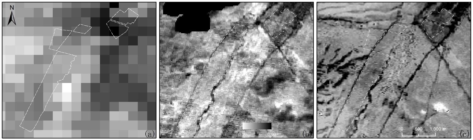
Fig.5 Three types of NDVI comparison
年份 Year | 研究区The study area | ||||||
|---|---|---|---|---|---|---|---|
| 指标Index | 1 | 2 | 3 | 4 | 5 | 整体All | |
| 2013 | MEAN | 3508.00 | 2062.67 | 1876.00 | 3249.78 | 2762.93 | 2876.56 |
| STD | 750.24 | 371.12 | 332.65 | 573.77 | 675.20 | 777.49 | |
| CV | 0.21 | 0.18 | 0.18 | 0.18 | 0.24 | 0.27 | |
| 2014 | MEAN | 3318.10 | 2415.50 | 2034.30 | 2123.85 | 2498.04 | 2524.62 |
| STD | 1279.95 | 771.33 | 383.13 | 494.95 | 576.57 | 1398.16 | |
| CV | 0.39 | 0.32 | 0.19 | 0.23 | 0.23 | 0.55 | |
| 2015 | MEAN | 2096.56 | 2236.48 | 2262.96 | 2370.00 | 2285.45 | 2263.90 |
| STD | 168.35 | 146.23 | 39.13 | 205.07 | 300.85 | 268.03 | |
| CV | 0.08 | 0.07 | 0.02 | 0.09 | 0.13 | 0.12 | |
| 2016 | MEAN | 3187.20 | 3436.00 | 3326.40 | 3158.40 | 2874.80 | 3049.45 |
| STD | 1058.61 | 430.28 | 780.75 | 709.26 | 703.17 | 768.73 | |
| CV | 0.33 | 0.13 | 0.23 | 0.22 | 0.24 | 0.25 | |
Table 7 Statistical analysis of measured data in each year
年份 Year | 研究区The study area | ||||||
|---|---|---|---|---|---|---|---|
| 指标Index | 1 | 2 | 3 | 4 | 5 | 整体All | |
| 2013 | MEAN | 3508.00 | 2062.67 | 1876.00 | 3249.78 | 2762.93 | 2876.56 |
| STD | 750.24 | 371.12 | 332.65 | 573.77 | 675.20 | 777.49 | |
| CV | 0.21 | 0.18 | 0.18 | 0.18 | 0.24 | 0.27 | |
| 2014 | MEAN | 3318.10 | 2415.50 | 2034.30 | 2123.85 | 2498.04 | 2524.62 |
| STD | 1279.95 | 771.33 | 383.13 | 494.95 | 576.57 | 1398.16 | |
| CV | 0.39 | 0.32 | 0.19 | 0.23 | 0.23 | 0.55 | |
| 2015 | MEAN | 2096.56 | 2236.48 | 2262.96 | 2370.00 | 2285.45 | 2263.90 |
| STD | 168.35 | 146.23 | 39.13 | 205.07 | 300.85 | 268.03 | |
| CV | 0.08 | 0.07 | 0.02 | 0.09 | 0.13 | 0.12 | |
| 2016 | MEAN | 3187.20 | 3436.00 | 3326.40 | 3158.40 | 2874.80 | 3049.45 |
| STD | 1058.61 | 430.28 | 780.75 | 709.26 | 703.17 | 768.73 | |
| CV | 0.33 | 0.13 | 0.23 | 0.22 | 0.24 | 0.25 | |
| 1 | Hopkins A. Relevance and functionality of semi-natural grassland in Europe-status quo and future prospective. Raumberg-Gumpenstein: International Workshop of the Salvere, 2009: 9-14. |
| 2 | Soussana J F, Loiseau P, Vuichard N, et al. Carbon cycling and sequestration opportunities in temperate grasslands. Soil Use & Management, 2004, 20(2): 219-230. |
| 3 | Hu Z M, Guo Q, Li S G, et al. Shifts in the dynamics of productivity signal ecosystem state transitions at the biome-scale. Ecology Letters, 2018, 21(10): 1457-1466. |
| 4 | Wang P, Deng X Z, Jiang S. Diffused impact of grassland degradation over space: A case study in Qinghai province. Physics and Chemistry of the Earth, 2017, 101: 166-171. |
| 5 | Xu B, Yang X C, Tao W G, et al. MODIS-based remote-sensing monitoring of the spatiotemporal patterns of China’s grassland vegetation growth. International Journal for Remote Sensing, 2013, 34(11): 3867-3878. |
| 6 | Gao T, Yang X C, Jin Y X, et al. Spatio-temporal variation in vegetation biomass and its relationships with climate factors in the Xilingol grasslands, Northern China. PLoS One, 2013, 8(12): e83824. |
| 7 | Xu D D, Guo X L. Some insights on grassland health assessment based on remote sensing. Sensors, 2015, 15(2): 3070-3089. |
| 8 | Ali I, Cawkwell F, Dwyer E, et al. Satellite remote sensing of grasslands: From observation to management——A review. Journal of Plant Ecology, 2016, 9(6): 649-671. |
| 9 | Meng B P, Ge J, Liang T G, et al. Evaluation of remote sensing inversion error for the above-ground biomass of alpine meadow grassland based on multi-source satellite data. Remote Sensing, 2017, 9(4): 372. |
| 10 | Williamson H D, Eldridge D J. Pasture status in a semi-arid grassland. International Journal of Remote Sensing, 1993, 14(13): 2535-2546. |
| 11 | Verbesselt J, Somers B, van Aardt J, et al. Monitoring herbaceous biomass and water content with SPOT VEGETATION time-series to improve fire risk assessment in savanna ecosystems. Remote Sensing of Environment, 2006, 101(3): 399-414. |
| 12 | Xu B, Yang X C, Tao W G, et al. Remote sensing monitoring upon the grass production in China. Acta Ecologica Sinica, 2007, 27(2): 405-413. |
| 徐斌, 杨秀春, 陶伟国, 等. 中国草原产草量遥感监测. 生态学报, 2007, 27(2): 405-413. | |
| 13 | Meng B P, Chen S Y, Cui X, et al. The accuracy of grassland vegetation biomass estimated model based on multi-source remote sensing data ——As a case of experimental area in Sangke grassland in Xiahe County. Pratacultural Science, 2015, 32(11): 1730-1739. |
| 孟宝平, 陈思宇, 崔霞, 等. 基于多源遥感数据的高寒草地生物量反演模型精度——以夏河县桑科草原试验区为例. 草业科学, 2015, 32(11): 1730-1739. | |
| 14 | Liang T G, Yang S X, Feng Q S, et al. Multi-factor modeling of above-ground biomass in alpine grassland: A case study in the Three-River Headwaters Region, China. Remote Sensing of Environment, 2016, 186(1): 164-172. |
| 15 | Gao F, Masek J, Schwaller M, et al. On the blending of the Landsat and MODIS surface reflectance: Predicting daily Landsat surface reflectance. IEEE Transactions on Geoscience and Remote Sensing, 2006, 44(8): 2207-2218. |
| 16 | Zhao Y L, Li D C, Jia X M, et al. Application evaluation of STARFM algorithm in generating wetland-type TM reflectance data. Computer Applications and Software, 2016, 33(3): 267-270, 283. |
| 赵艳丽, 李大成, 贾琇明, 等. STARFM算法生成湿地类型TM反射率数据的应用评价. 计算机应用与软件, 2016, 33(3): 267-270, 283. | |
| 17 | Tian L. The extraction of crop planting structure and its dynamic monitoring of Huangshui Basin from 2000 to 2015 combined with STARFM model. Chongqing: Xi’nan University, 2018. |
| 田罗. 结合STARFM模型的2000-2015年湟水流域农作物种植结构提取及其动态分析. 重庆: 西南大学, 2018. | |
| 18 | Peters F. Analyzing the phenologic dynamics of kudzu (Pueraria montana) infestations using remote sensing and the normalized difference vegetation index. Lousisville: The University of Lousisville, 2016. |
| 19 | Padarian J, Minasny B, Malone B, et al. Digital soil mapping in the cloud using Google Earth Engine. Computers & Geosciences, 2015, 83: 80-88. |
| 20 | Hansen M C, Potapov P V, Moore R, et al. High-resolution global maps of 21st-century forest cover change. Science, 2013, 342(6160): 850-853. |
| 21 | Patel N N, Angiuli E, Gamba P, et al. Multitemporal settlement and population mapping from Landsat using Google Earth Engine. International Journal of Applied Earth Observation and Geoinformation, 2015, 35: 199-208. |
| 22 | Lobell D B, Thau D, Seifert C, et al. A scalable satellite-based crop yield mapper. Remote Sensing of Environment, 2015, 164(11): 324-333. |
| 23 | Yang S X, Feng Q S, Liang T G, et al. Modeling grassland above-ground biomass based on artificial neural network and remote sensing in the Three-River Headwaters Region. Remote Sensing of Environment, 2018, 204: 448-455. |
| 24 | Feng Q S, Gao X H, Huang X D, et al. Remote sensing dynamic monitoring of grass growth in Qinghai-Tibet Plateau from 2001 to 2010. Journal of Lanzhou University, 2011, 47(4): 75-81, 90. |
| 冯琦胜, 高新华, 黄晓东, 等. 2001-2010年青藏高原草地生长状况遥感动态监测. 兰州大学学报, 2011, 47(4): 75-81, 90. | |
| 25 | Cui X, Guo Z G, Liang T G, et al. Classification management for grassland using MODIS data: A case study in the Gannan region, China. International Journal of Remote Sensing, 2012, 33(10): 3156-3175. |
| 26 | Wang Y, Xia W T, Liang T G, et al. Spatial and temporal dynamic changes of net primary product based on MODIS vegetation index in Gannan grassland. Acta Prataculturae Sinica, 2010, 19(1): 201-210. |
| 王莺, 夏文韬, 梁天刚, 等. 基于MODIS植被指数的甘南草地净初级生产力时空变化研究. 草业学报, 2010, 19(1): 201-210. | |
| 27 | Bao H M. Dynamic monitoring and prediction of aboveground biomass of natural grassland—A case study in Xiahe County of Gansu Province. Lanzhou: Gansu Agricultural University, 2010. |
| 包海明. 天然草地地上生物量动态监测与预测—以甘肃夏河县为例. 兰州: 甘肃农业大学, 2010. | |
| 28 | Li F, Zeng Y, Luo J H, et al. Modeling grassland aboveground biomass using a pure vegetation index. Ecological Indicators, 2016, 62: 279-288. |
| 29 | Liu M, Liu G H, Gong L, et al. Relationships of biomass with environmental factors in the grassland area of Hulunbuir, China. PLoS One, 2014, 9(7): e102344. |
| 30 | Gao T, Xu B, Yang X C, et al. Using MODIS time series data to estimate aboveground biomass and its spatio-temporal variation in Inner Mongolia’s grassland between 2001 and 2011. International Journal of Remote Sensing, 2013, 34(21): 7796-7810. |
| 31 | Li F, Jiang L, Wang X F, et al. Estimating grassland aboveground biomass using multitemporal MODIS data in the West Songnen Plain, China. Journal of Applied Remote Sensing, 2013, 7(1): 073546. |
| 32 | Diouf A A, Hiernaux P, Brandt M, et al. Do agrometeorological data improve optical satellite-based estimations of the Herbaceous yield in Sahelian semi-arid ecosystems? Remote Sensing, 2016, 8(8): 668. |
| 33 | Hilker T, Wulder M A, Coops N, et al. Generation of dense time series synthetic Landsat data through data blending with MODIS using a spatial and temporal adaptive reflectance fusion model. Remote Sensing of Environment, 2009, 113(9): 1988-1999. |
| 34 | Singh D. Generation and evaluation of gross primary productivity using Landsat data through blending with MODIS data. International Journal of Applied Earth Observations & Geoinformation, 2011, 13(1): 59-69. |
| 35 | Watts J, Powell S L, Lawrence R L, et al. Improved classification of conservation tillage adoption using high temporal and synthetic satellite imagery. Remote Sensing of Environment, 2011, 115(1): 66-75. |
| [1] | Xiao-lei ZHOU, Yue-e YAN, Jing ZHANG, Xu-jiao ZHOU, Yong-qin YAN, Fu-qiang YANG, Xue-ping CAO, An ZHAO, Yan-li ZHAO, Jing-yi SU. Vegetation community structure and diversity in a burned area of Picea asperata-Abies fabri forest on different aspects on the northeastern margin of the Qinghai-Tibetan Plateau [J]. Acta Prataculturae Sinica, 2022, 31(5): 144-155. |
| [2] | Yong-mei LIU, Xing-zhi DONG, Yong-qing LONG, Zhi-mei ZHU, Lei WANG, Xing-hua GE, Fan ZHAO, Jing-zhong LI. Classification of Stellera chamaejasme communities and their relationships with environmental factors in degraded alpine meadow in the central Qilian Mountains, Qinghai Province [J]. Acta Prataculturae Sinica, 2022, 31(4): 1-11. |
| [3] | Xin LI, Xue WEI, Chang-ting WANG, Xiao REN, Peng-fei WU. Effects of exogenous nutrient addition on alpine meadow soil arthropod communities [J]. Acta Prataculturae Sinica, 2022, 31(4): 155-164. |
| [4] | Cai-cai SUN, Quan-min DONG, Wen-ting LIU, Bin FENG, Guang SHI, Yu-zhen LIU, Yang YU, Chun-ping ZHANG, Xiao-fang ZHANG, Cai-di LI, Zeng-zeng YANG, Xiao-xia YANG. Effects of grazing modes on the community structure and diversity of soil arthropod in an alpine meadow on the Qinghai-Tibetan Plateau [J]. Acta Prataculturae Sinica, 2022, 31(2): 62-75. |
| [5] | Ren-ping ZHANG, Jing GUO, Xiao-fang MA, Wei-yong GUO. Grassland phenology extraction for Xinjiang Province and trend analysis using MODIS data [J]. Acta Prataculturae Sinica, 2022, 31(1): 1-12. |
| [6] | Xin YANG, Wen-xia CAO, Xiao-jun YU, Hai-bin WANG, Yuan-yuan HAO. Dynamic monitoring of grassland resources and their responses to environmental factors in Qinghai Province based on analyses of daily MODIS NDVI data from the past 20 years [J]. Acta Prataculturae Sinica, 2021, 30(9): 1-14. |
| [7] | Li-tao TANG, Rui MAO, Chang-ting WANG, Jie LI, Lei HU, Hong-biao ZI. Effects of nitrogen and phosphorus addition on root characteristics of alpine meadow [J]. Acta Prataculturae Sinica, 2021, 30(9): 105-116. |
| [8] | Xiao-ding LIN, Le CHANG, Dan FENG. Remote-sensing estimation of vegetation gross primary productivity and its spatiotemporal changes in Qinghai Province from 2000 to 2019 [J]. Acta Prataculturae Sinica, 2021, 30(6): 16-27. |
| [9] | Wei ZHANG, Shu-hua YI, Yu QIN, Dong-hui SHANGGUAN, Yan QIN. Analysis of features and influencing factors of alpine meadow surface temperature based on UAV thermal thermography [J]. Acta Prataculturae Sinica, 2021, 30(3): 15-27. |
| [10] | Wen-rong LUO, Guo-zheng HU, Ganjurjav H, Qing-zhu GAO, Yan LI, Yi-qing Ge, Yu LI, Shi-cheng HE, Luo-bu DANJIU. Effects of simulated drought on plant phenology and productivity in an alpine meadow in Northern Tibet [J]. Acta Prataculturae Sinica, 2021, 30(2): 82-92. |
| [11] | WANG Xiu-yu, HUANG Xiao-xia, HE Ke-jian, SUN Xiao-neng, LÜZENG Zhe-zhou, ZHANG Yong, ZHU Mei, ZENG Rui-qin. The relationship between plant functional traits and soil physicochemical properties in alpine meadows in Northwestern Yunnan Province, China [J]. Acta Prataculturae Sinica, 2020, 29(8): 6-17. |
| [12] | XU Tian-wei, ZHAO Jiong-chang, MAO Shao-juan, GENG Yuan-yue, LIU Hong-jin, ZHAO Xin-quan, XU Shi-xiao. Response of plant community structure and biomass to short-term rest grazing in an alpine meadow in Haibei Autonomous Prefecture of Qinghai [J]. Acta Prataculturae Sinica, 2020, 29(4): 1-8. |
| [13] | WU Ni-tu, LIU Gui-xiang, YANG Yong, SONG Xiang-yang, BAI Hai-hua. Dynamic monitoring of net primary productivity and its response to climate factors in native grassland in Inner Mongolia using a light-use efficiency model [J]. Acta Prataculturae Sinica, 2020, 29(11): 1-10. |
| [14] | YANG Yang, TIAN Li-hua, TIAN Hao-qi, SUN Huai-en, ZHAO Jing-xue, ZHOU Qing-ping. Effect of climate warming on decomposition of plant litter in alpine meadow pastures in Northwestern Sichuan [J]. Acta Prataculturae Sinica, 2020, 29(10): 35-46. |
| [15] | MA Hai-xia, ZHANG De-gang, CHEN Jin, GUO Chun-xiu, DONG Yong-ping, MA Yuan, KANG Yu-kun, CHEN Lu, DU Kai, CHEN Jian-gang. Change in factors influencing soil water holding capacity at microsites along a slope transect in alpine meadow in the eastern Qilian Mountains [J]. Acta Prataculturae Sinica, 2020, 29(1): 28-37. |
| Viewed | ||||||
|
Full text |
|
|||||
|
Abstract |
|
|||||