

ISSN 1004-5759 CN 62-1105/S
草业学报 ›› 2022, Vol. 31 ›› Issue (6): 23-34.DOI: 10.11686/cyxb2021180
张玉琢1( ), 杨志贵1, 于红妍2, 张强3, 杨淑霞3, 赵婷1, 许画画1, 孟宝平1(), 吕燕燕1
收稿日期:2021-05-07
修回日期:2021-06-21
出版日期:2022-06-20
发布日期:2022-05-11
通讯作者:
孟宝平
作者简介:E-mail: mengbp09@lzu.edu.cn基金资助:
Yu-zhuo ZHANG1(), Zhi-gui YANG1, Hong-yan YU2, Qiang ZHANG3, Shu-xia YANG3, Ting ZHAO1, Hua-hua XU1, Bao-ping MENG1(), Yan-yan LV1
Received:2021-05-07
Revised:2021-06-21
Online:2022-06-20
Published:2022-05-11
Contact:
Bao-ping MENG
摘要:
遥感数据具有实时、动态、大范围等特点,在草地资源监测与管理研究中获得了广泛应用。然而,单一的遥感植被指数无法同时满足草地地上生物量观测中时空分辨率的需求。因此,本研究基于时间序列Landsat NDVI和MODIS NDVI数据,结合时空融合算法(spatial and temporal adaptive reflectance fusion model, STARFM),生成了2000-2016年高时空分辨率的植被指数数据集(NDVISTARFM,时间分辨率为16 d,空间分辨率为30 m),并基于2013-2016年地面实测草地地上生物量数据,构建了夏河县桑科草原高寒草地地上生物量遥感反演模型,分析了2000-2016年研究区草地地上生物量生长状况和变化趋势。结果表明:1)基于NDVISTARFM的最优估测模型为乘幂模型,其R2为0.58,均方根误差(root mean square error, RMSE)为795.62 kg·hm-2,模型的表现能力次于Landsat NDVI最优估测模型(R2=0.76,RMSE=634.83 kg·hm-2),而优于MODIS NDVI最优估测模型(R2=0.24,RMSE=937.79 kg·hm-2);2)基于NDVISTARFM最优估测模型对各样区草地地上生物量总产的估测精度优于MODIS NDVI而次于Landsat NDVI,总体精度达84.05%;3)2000-2016年来,夏河县研究区草地地上生物量总体呈现增加趋势,其中90%左右的区域年增量大于30 kg·hm-2,草地地上生物量呈现减少趋势的区域仅占2.30%。
张玉琢, 杨志贵, 于红妍, 张强, 杨淑霞, 赵婷, 许画画, 孟宝平, 吕燕燕. 基于STARFM的草地地上生物量遥感估测研究——以甘肃省夏河县桑科草原为例[J]. 草业学报, 2022, 31(6): 23-34.
Yu-zhuo ZHANG, Zhi-gui YANG, Hong-yan YU, Qiang ZHANG, Shu-xia YANG, Ting ZHAO, Hua-hua XU, Bao-ping MENG, Yan-yan LV. Estimating grassland above ground biomass based on the STARFM algorithm and remote sensing data——A case study in the Sangke grassland in Xiahe County, Gansu Province[J]. Acta Prataculturae Sinica, 2022, 31(6): 23-34.

图1 研究区概况a为研究区位置;b为草地AGB采样点分布;c、d和e分别为研究区2013年8月8日Landsat 8 OLI真彩色合成图像以及Landsat 8 OLI和MOD13Q1 NDVI植被指数。a is the location of the study area; b is the distribution of AGB sampling sites in grassland; c, d and e are the real-color composite images of Landsat 8 OLI, NDVI of Landsat 8 OLI and MOD13Q1 in the study area on August 8, 2013.
Fig.1 Overview of the study area
MODIS影像日期 Date of MODIS image | Landsat影像日期 Date of Landsat image | 采样时间 Sampling time | 样地数 Number of plots | 样方数 Number of samples |
|---|---|---|---|---|
| 2013-08-13 | 2013-08-08 | 2013-08-08 | 11 | 55 |
| 2014-07-28 | 2014-07-26 | 2014-07-28 | 13 | 65 |
| 2015-07-12 | 2015-07-13 | 2015-07-13 | 13 | 65 |
| 2016-07-27 | 2016-07-31 | 2016-07-26 | 11 | 55 |
表1 研究区遥感影像及外业调查时间
Table 1 Date remote sensing image and field survey
MODIS影像日期 Date of MODIS image | Landsat影像日期 Date of Landsat image | 采样时间 Sampling time | 样地数 Number of plots | 样方数 Number of samples |
|---|---|---|---|---|
| 2013-08-13 | 2013-08-08 | 2013-08-08 | 11 | 55 |
| 2014-07-28 | 2014-07-26 | 2014-07-28 | 13 | 65 |
| 2015-07-12 | 2015-07-13 | 2015-07-13 | 13 | 65 |
| 2016-07-27 | 2016-07-31 | 2016-07-26 | 11 | 55 |
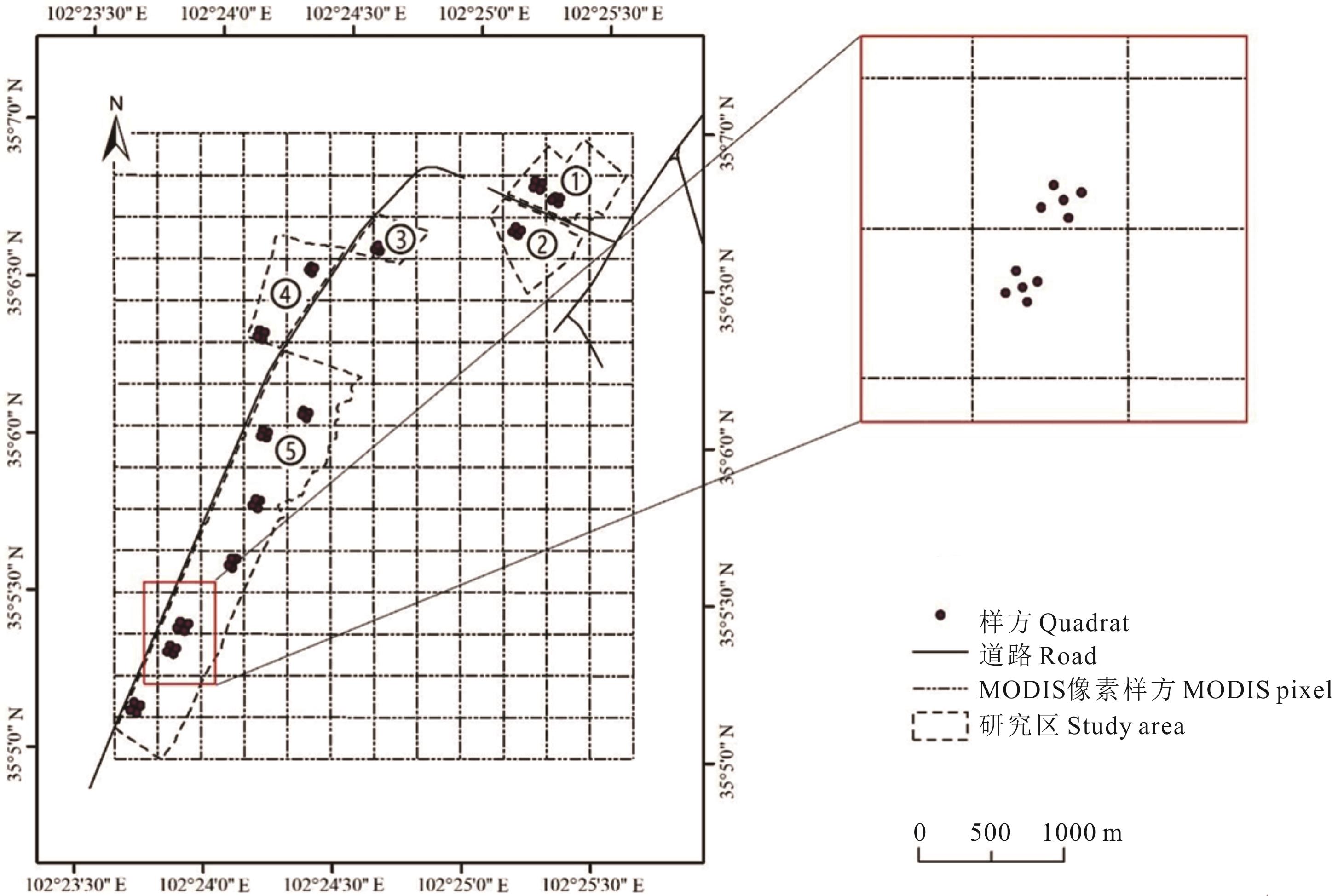
图2 研究区采样点分布
Fig.2 Distribution of sample sites in the study area

图3 MODIS和Landsat影像数据
Fig.3 MODIS and Landsat image data
| 植被指数和生物量Vegetation index and biomass | 最大值Max | 最小值Min | 平均值Mean | 标准偏差STD | 变异系数CV |
|---|---|---|---|---|---|
| NDVIMODIS | 0.84 | 0.58 | 0.74 | 0.08 | 0.15 |
| NDVILandsat | 0.91 | 0.55 | 0.77 | 0.10 | 0.13 |
| NDVISTARFM | 0.95 | 0.47 | 0.72 | 0.11 | 0.17 |
| 生物量Biomass (kg·hm-2) | 3997.33 | 745.52 | 2299.30 | 972.60 | 0.42 |
表2 研究区植被指数和草地生物量统计性描述
Table 2 Statistical description of vegetation index and grassland biomass in the study area
| 植被指数和生物量Vegetation index and biomass | 最大值Max | 最小值Min | 平均值Mean | 标准偏差STD | 变异系数CV |
|---|---|---|---|---|---|
| NDVIMODIS | 0.84 | 0.58 | 0.74 | 0.08 | 0.15 |
| NDVILandsat | 0.91 | 0.55 | 0.77 | 0.10 | 0.13 |
| NDVISTARFM | 0.95 | 0.47 | 0.72 | 0.11 | 0.17 |
| 生物量Biomass (kg·hm-2) | 3997.33 | 745.52 | 2299.30 | 972.60 | 0.42 |
植被指数 Vegetation index | 线性Linear | 对数Logarithmic | 乘幂Power | 指数Exponential | ||||
|---|---|---|---|---|---|---|---|---|
| R2 | RMSE | R2 | RMSE | R2 | RMSE | R2 | RMSE | |
| NDVIMODIS | 0.17 | 917.21 | 0.17 | 916.80 | 0.24 | 937.79 | 0.24 | 940.72 |
| NDVILandsat | 0.65 | 586.72 | 0.66 | 576.76 | 0.76 | 634.83 | 0.75 | 665.32 |
| NDVISTARFM | 0.49 | 714.93 | 0.52 | 690.97 | 0.58 | 795.62 | 0.54 | 847.99 |
表3 研究区草地生物量回归模型精度检验
Table 3 Accuracy validation of biomass regression models in study area
植被指数 Vegetation index | 线性Linear | 对数Logarithmic | 乘幂Power | 指数Exponential | ||||
|---|---|---|---|---|---|---|---|---|
| R2 | RMSE | R2 | RMSE | R2 | RMSE | R2 | RMSE | |
| NDVIMODIS | 0.17 | 917.21 | 0.17 | 916.80 | 0.24 | 937.79 | 0.24 | 940.72 |
| NDVILandsat | 0.65 | 586.72 | 0.66 | 576.76 | 0.76 | 634.83 | 0.75 | 665.32 |
| NDVISTARFM | 0.49 | 714.93 | 0.52 | 690.97 | 0.58 | 795.62 | 0.54 | 847.99 |
植被指数 Vegetation index | 参数估计和T检验Parameter estimation and T test | 回归显著性检验Regression significance test | |||
|---|---|---|---|---|---|
| 参数Parameter | 估计值Estimated value | T | R2 | F | |
| NDVIMODIS | A B | 2.64 4561.14 | 3.81 4.55 | 0.24 | 14.52** |
| NDVILandsat | A B | 3.37 5031.89 | 12.13 12.09 | 0.76 | 147.19** |
| NDVISTARFM | A B | 2.49 4812.23 | 7.92 8.44 | 0.58 | 62.75** |
表4 最优反演模型参数T检验和回归显著性F检验
Table 4 T test and F test for optimal inversion model
植被指数 Vegetation index | 参数估计和T检验Parameter estimation and T test | 回归显著性检验Regression significance test | |||
|---|---|---|---|---|---|
| 参数Parameter | 估计值Estimated value | T | R2 | F | |
| NDVIMODIS | A B | 2.64 4561.14 | 3.81 4.55 | 0.24 | 14.52** |
| NDVILandsat | A B | 3.37 5031.89 | 12.13 12.09 | 0.76 | 147.19** |
| NDVISTARFM | A B | 2.49 4812.23 | 7.92 8.44 | 0.58 | 62.75** |
植被指数 Vegetation index | 模型 Model | 模型公式 Formulas | R2 | RMSE (kg·hm-2) |
|---|---|---|---|---|
| NDVIMODIS | 乘幂Power | y=114.03x2.6373 | 0.24 | 937.79 |
| NDVILandsat | 乘幂Power | y=125.80x3.3683 | 0.76 | 634.83 |
| NDVISTARFM | 乘幂Power | y=120.31x2.4920 | 0.58 | 795.62 |
表5 基于NDVILandsat、NDVIMODIS和NDVISTARFM最优AGB估测模型
Table 5 The optimal AGB estimation model based on NDVILandsat, NDVIMODIS and NDVISTARFM
植被指数 Vegetation index | 模型 Model | 模型公式 Formulas | R2 | RMSE (kg·hm-2) |
|---|---|---|---|---|
| NDVIMODIS | 乘幂Power | y=114.03x2.6373 | 0.24 | 937.79 |
| NDVILandsat | 乘幂Power | y=125.80x3.3683 | 0.76 | 634.83 |
| NDVISTARFM | 乘幂Power | y=120.31x2.4920 | 0.58 | 795.62 |
样区 Plot | 指标 Norm | 植被指数 Vegetation index | ||
|---|---|---|---|---|
| NDVIMODIS | NDVILandsat | NDVISTARFM | ||
| 1号样区Plot No.1 | 绝对误差Absolute error (×104 kg) | 2.99 | 2.25 | 1.91 |
| 相对误差Relative error (%) | 45.96 | 34.67 | 29.37 | |
| 2号样区Plot No.2 | 绝对误差Absolute error (×104 kg) | 1.55 | 1.06 | 0.43 |
| 相对误差Relative error (%) | 39.78 | 27.28 | 11.04 | |
| 3号样区Plot No.3 | 绝对误差Absolute error (×104 kg) | 0.75 | 0.51 | 0.20 |
| 相对误差Relative error (%) | 36.85 | 25.29 | 11.04 | |
| 4号样区Plot No.4 | 绝对误差Absolute error (×104 kg) | 1.35 | 0.65 | 0.77 |
| 相对误差Relative error (%) | 24.88 | 12.01 | 9.95 | |
| 5号样区Plot No.5 | 绝对误差Absolute error (×104 kg) | 3.26 | 2.61 | 4.25 |
| 相对误差Relative error (%) | 12.21 | 9.80 | 14.23 | |
| 研究区All study area | 绝对误差Absolute error (×104 kg) | 9.89 | 3.45 | 5.75 |
| 相对误差Relative error (%) | 22.22 | 7.75 | 15.95 | |
表6 基于NDVILandsat、NDVIMODIS和NDVISTARFM最优估测模型的研究区草地产草量的精度评价
Table 6 Accuracy evaluation of the inversion biomass based on NDVILandsat, NDVIMODIS and NDVISTARFM
样区 Plot | 指标 Norm | 植被指数 Vegetation index | ||
|---|---|---|---|---|
| NDVIMODIS | NDVILandsat | NDVISTARFM | ||
| 1号样区Plot No.1 | 绝对误差Absolute error (×104 kg) | 2.99 | 2.25 | 1.91 |
| 相对误差Relative error (%) | 45.96 | 34.67 | 29.37 | |
| 2号样区Plot No.2 | 绝对误差Absolute error (×104 kg) | 1.55 | 1.06 | 0.43 |
| 相对误差Relative error (%) | 39.78 | 27.28 | 11.04 | |
| 3号样区Plot No.3 | 绝对误差Absolute error (×104 kg) | 0.75 | 0.51 | 0.20 |
| 相对误差Relative error (%) | 36.85 | 25.29 | 11.04 | |
| 4号样区Plot No.4 | 绝对误差Absolute error (×104 kg) | 1.35 | 0.65 | 0.77 |
| 相对误差Relative error (%) | 24.88 | 12.01 | 9.95 | |
| 5号样区Plot No.5 | 绝对误差Absolute error (×104 kg) | 3.26 | 2.61 | 4.25 |
| 相对误差Relative error (%) | 12.21 | 9.80 | 14.23 | |
| 研究区All study area | 绝对误差Absolute error (×104 kg) | 9.89 | 3.45 | 5.75 |
| 相对误差Relative error (%) | 22.22 | 7.75 | 15.95 | |
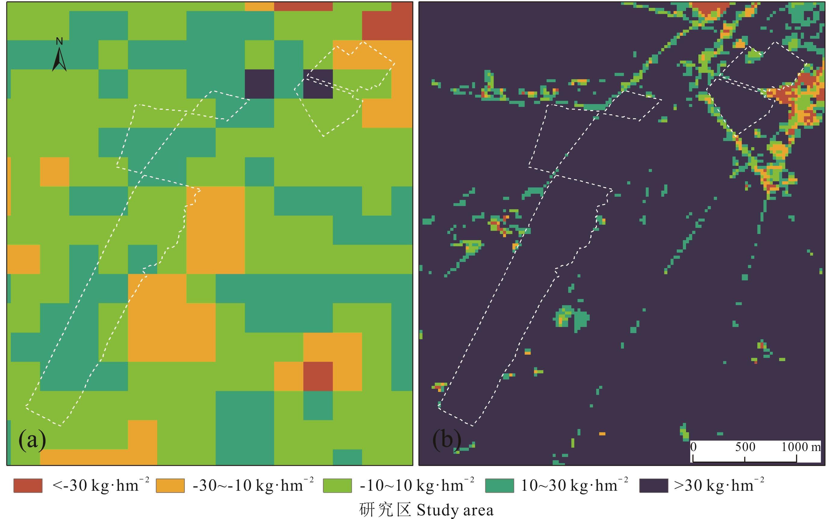
图4 基于NDVISTARFM和NDVIMODIS最优估测模型反演的草地AGB年最大值slope动态变化a和b分别为基于NDVIMODIS和NDVISTARFM最优估测模型反演的草地AGB年最大值slope动态变化;AGB年变化量单位为kg·hm-2·year-1。a and b are the slope dynamic variation of annual maximum grassland AGB based on the optimal estimation models of NDVIMODIS and NDVISTARFM,respectively; The unit of annual variation of aboveground biomass is kg·hm-2·year-1.
Fig.4 The slope dynamic variation of annual maximum grassland AGB based on the optimal estimation model of NDVISTARFM and NDVIMODIS
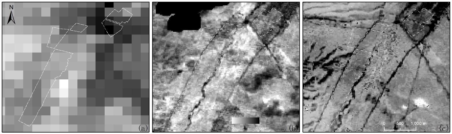
图5 3种NDVI对比(a)为MODIS NDVI, (b)为Landsat NDVI,(c)为融合后NDVI。(a) is MODIS NDVI, (b) is Landsat NDVI, (c) is NDVI after fusion.
Fig.5 Three types of NDVI comparison
年份 Year | 研究区The study area | ||||||
|---|---|---|---|---|---|---|---|
| 指标Index | 1 | 2 | 3 | 4 | 5 | 整体All | |
| 2013 | MEAN | 3508.00 | 2062.67 | 1876.00 | 3249.78 | 2762.93 | 2876.56 |
| STD | 750.24 | 371.12 | 332.65 | 573.77 | 675.20 | 777.49 | |
| CV | 0.21 | 0.18 | 0.18 | 0.18 | 0.24 | 0.27 | |
| 2014 | MEAN | 3318.10 | 2415.50 | 2034.30 | 2123.85 | 2498.04 | 2524.62 |
| STD | 1279.95 | 771.33 | 383.13 | 494.95 | 576.57 | 1398.16 | |
| CV | 0.39 | 0.32 | 0.19 | 0.23 | 0.23 | 0.55 | |
| 2015 | MEAN | 2096.56 | 2236.48 | 2262.96 | 2370.00 | 2285.45 | 2263.90 |
| STD | 168.35 | 146.23 | 39.13 | 205.07 | 300.85 | 268.03 | |
| CV | 0.08 | 0.07 | 0.02 | 0.09 | 0.13 | 0.12 | |
| 2016 | MEAN | 3187.20 | 3436.00 | 3326.40 | 3158.40 | 2874.80 | 3049.45 |
| STD | 1058.61 | 430.28 | 780.75 | 709.26 | 703.17 | 768.73 | |
| CV | 0.33 | 0.13 | 0.23 | 0.22 | 0.24 | 0.25 | |
表7 各年份的实测数据统计性分析
Table 7 Statistical analysis of measured data in each year
年份 Year | 研究区The study area | ||||||
|---|---|---|---|---|---|---|---|
| 指标Index | 1 | 2 | 3 | 4 | 5 | 整体All | |
| 2013 | MEAN | 3508.00 | 2062.67 | 1876.00 | 3249.78 | 2762.93 | 2876.56 |
| STD | 750.24 | 371.12 | 332.65 | 573.77 | 675.20 | 777.49 | |
| CV | 0.21 | 0.18 | 0.18 | 0.18 | 0.24 | 0.27 | |
| 2014 | MEAN | 3318.10 | 2415.50 | 2034.30 | 2123.85 | 2498.04 | 2524.62 |
| STD | 1279.95 | 771.33 | 383.13 | 494.95 | 576.57 | 1398.16 | |
| CV | 0.39 | 0.32 | 0.19 | 0.23 | 0.23 | 0.55 | |
| 2015 | MEAN | 2096.56 | 2236.48 | 2262.96 | 2370.00 | 2285.45 | 2263.90 |
| STD | 168.35 | 146.23 | 39.13 | 205.07 | 300.85 | 268.03 | |
| CV | 0.08 | 0.07 | 0.02 | 0.09 | 0.13 | 0.12 | |
| 2016 | MEAN | 3187.20 | 3436.00 | 3326.40 | 3158.40 | 2874.80 | 3049.45 |
| STD | 1058.61 | 430.28 | 780.75 | 709.26 | 703.17 | 768.73 | |
| CV | 0.33 | 0.13 | 0.23 | 0.22 | 0.24 | 0.25 | |
| 1 | Hopkins A. Relevance and functionality of semi-natural grassland in Europe-status quo and future prospective. Raumberg-Gumpenstein: International Workshop of the Salvere, 2009: 9-14. |
| 2 | Soussana J F, Loiseau P, Vuichard N, et al. Carbon cycling and sequestration opportunities in temperate grasslands. Soil Use & Management, 2004, 20(2): 219-230. |
| 3 | Hu Z M, Guo Q, Li S G, et al. Shifts in the dynamics of productivity signal ecosystem state transitions at the biome-scale. Ecology Letters, 2018, 21(10): 1457-1466. |
| 4 | Wang P, Deng X Z, Jiang S. Diffused impact of grassland degradation over space: A case study in Qinghai province. Physics and Chemistry of the Earth, 2017, 101: 166-171. |
| 5 | Xu B, Yang X C, Tao W G, et al. MODIS-based remote-sensing monitoring of the spatiotemporal patterns of China’s grassland vegetation growth. International Journal for Remote Sensing, 2013, 34(11): 3867-3878. |
| 6 | Gao T, Yang X C, Jin Y X, et al. Spatio-temporal variation in vegetation biomass and its relationships with climate factors in the Xilingol grasslands, Northern China. PLoS One, 2013, 8(12): e83824. |
| 7 | Xu D D, Guo X L. Some insights on grassland health assessment based on remote sensing. Sensors, 2015, 15(2): 3070-3089. |
| 8 | Ali I, Cawkwell F, Dwyer E, et al. Satellite remote sensing of grasslands: From observation to management——A review. Journal of Plant Ecology, 2016, 9(6): 649-671. |
| 9 | Meng B P, Ge J, Liang T G, et al. Evaluation of remote sensing inversion error for the above-ground biomass of alpine meadow grassland based on multi-source satellite data. Remote Sensing, 2017, 9(4): 372. |
| 10 | Williamson H D, Eldridge D J. Pasture status in a semi-arid grassland. International Journal of Remote Sensing, 1993, 14(13): 2535-2546. |
| 11 | Verbesselt J, Somers B, van Aardt J, et al. Monitoring herbaceous biomass and water content with SPOT VEGETATION time-series to improve fire risk assessment in savanna ecosystems. Remote Sensing of Environment, 2006, 101(3): 399-414. |
| 12 | Xu B, Yang X C, Tao W G, et al. Remote sensing monitoring upon the grass production in China. Acta Ecologica Sinica, 2007, 27(2): 405-413. |
| 徐斌, 杨秀春, 陶伟国, 等. 中国草原产草量遥感监测. 生态学报, 2007, 27(2): 405-413. | |
| 13 | Meng B P, Chen S Y, Cui X, et al. The accuracy of grassland vegetation biomass estimated model based on multi-source remote sensing data ——As a case of experimental area in Sangke grassland in Xiahe County. Pratacultural Science, 2015, 32(11): 1730-1739. |
| 孟宝平, 陈思宇, 崔霞, 等. 基于多源遥感数据的高寒草地生物量反演模型精度——以夏河县桑科草原试验区为例. 草业科学, 2015, 32(11): 1730-1739. | |
| 14 | Liang T G, Yang S X, Feng Q S, et al. Multi-factor modeling of above-ground biomass in alpine grassland: A case study in the Three-River Headwaters Region, China. Remote Sensing of Environment, 2016, 186(1): 164-172. |
| 15 | Gao F, Masek J, Schwaller M, et al. On the blending of the Landsat and MODIS surface reflectance: Predicting daily Landsat surface reflectance. IEEE Transactions on Geoscience and Remote Sensing, 2006, 44(8): 2207-2218. |
| 16 | Zhao Y L, Li D C, Jia X M, et al. Application evaluation of STARFM algorithm in generating wetland-type TM reflectance data. Computer Applications and Software, 2016, 33(3): 267-270, 283. |
| 赵艳丽, 李大成, 贾琇明, 等. STARFM算法生成湿地类型TM反射率数据的应用评价. 计算机应用与软件, 2016, 33(3): 267-270, 283. | |
| 17 | Tian L. The extraction of crop planting structure and its dynamic monitoring of Huangshui Basin from 2000 to 2015 combined with STARFM model. Chongqing: Xi’nan University, 2018. |
| 田罗. 结合STARFM模型的2000-2015年湟水流域农作物种植结构提取及其动态分析. 重庆: 西南大学, 2018. | |
| 18 | Peters F. Analyzing the phenologic dynamics of kudzu (Pueraria montana) infestations using remote sensing and the normalized difference vegetation index. Lousisville: The University of Lousisville, 2016. |
| 19 | Padarian J, Minasny B, Malone B, et al. Digital soil mapping in the cloud using Google Earth Engine. Computers & Geosciences, 2015, 83: 80-88. |
| 20 | Hansen M C, Potapov P V, Moore R, et al. High-resolution global maps of 21st-century forest cover change. Science, 2013, 342(6160): 850-853. |
| 21 | Patel N N, Angiuli E, Gamba P, et al. Multitemporal settlement and population mapping from Landsat using Google Earth Engine. International Journal of Applied Earth Observation and Geoinformation, 2015, 35: 199-208. |
| 22 | Lobell D B, Thau D, Seifert C, et al. A scalable satellite-based crop yield mapper. Remote Sensing of Environment, 2015, 164(11): 324-333. |
| 23 | Yang S X, Feng Q S, Liang T G, et al. Modeling grassland above-ground biomass based on artificial neural network and remote sensing in the Three-River Headwaters Region. Remote Sensing of Environment, 2018, 204: 448-455. |
| 24 | Feng Q S, Gao X H, Huang X D, et al. Remote sensing dynamic monitoring of grass growth in Qinghai-Tibet Plateau from 2001 to 2010. Journal of Lanzhou University, 2011, 47(4): 75-81, 90. |
| 冯琦胜, 高新华, 黄晓东, 等. 2001-2010年青藏高原草地生长状况遥感动态监测. 兰州大学学报, 2011, 47(4): 75-81, 90. | |
| 25 | Cui X, Guo Z G, Liang T G, et al. Classification management for grassland using MODIS data: A case study in the Gannan region, China. International Journal of Remote Sensing, 2012, 33(10): 3156-3175. |
| 26 | Wang Y, Xia W T, Liang T G, et al. Spatial and temporal dynamic changes of net primary product based on MODIS vegetation index in Gannan grassland. Acta Prataculturae Sinica, 2010, 19(1): 201-210. |
| 王莺, 夏文韬, 梁天刚, 等. 基于MODIS植被指数的甘南草地净初级生产力时空变化研究. 草业学报, 2010, 19(1): 201-210. | |
| 27 | Bao H M. Dynamic monitoring and prediction of aboveground biomass of natural grassland—A case study in Xiahe County of Gansu Province. Lanzhou: Gansu Agricultural University, 2010. |
| 包海明. 天然草地地上生物量动态监测与预测—以甘肃夏河县为例. 兰州: 甘肃农业大学, 2010. | |
| 28 | Li F, Zeng Y, Luo J H, et al. Modeling grassland aboveground biomass using a pure vegetation index. Ecological Indicators, 2016, 62: 279-288. |
| 29 | Liu M, Liu G H, Gong L, et al. Relationships of biomass with environmental factors in the grassland area of Hulunbuir, China. PLoS One, 2014, 9(7): e102344. |
| 30 | Gao T, Xu B, Yang X C, et al. Using MODIS time series data to estimate aboveground biomass and its spatio-temporal variation in Inner Mongolia’s grassland between 2001 and 2011. International Journal of Remote Sensing, 2013, 34(21): 7796-7810. |
| 31 | Li F, Jiang L, Wang X F, et al. Estimating grassland aboveground biomass using multitemporal MODIS data in the West Songnen Plain, China. Journal of Applied Remote Sensing, 2013, 7(1): 073546. |
| 32 | Diouf A A, Hiernaux P, Brandt M, et al. Do agrometeorological data improve optical satellite-based estimations of the Herbaceous yield in Sahelian semi-arid ecosystems? Remote Sensing, 2016, 8(8): 668. |
| 33 | Hilker T, Wulder M A, Coops N, et al. Generation of dense time series synthetic Landsat data through data blending with MODIS using a spatial and temporal adaptive reflectance fusion model. Remote Sensing of Environment, 2009, 113(9): 1988-1999. |
| 34 | Singh D. Generation and evaluation of gross primary productivity using Landsat data through blending with MODIS data. International Journal of Applied Earth Observations & Geoinformation, 2011, 13(1): 59-69. |
| 35 | Watts J, Powell S L, Lawrence R L, et al. Improved classification of conservation tillage adoption using high temporal and synthetic satellite imagery. Remote Sensing of Environment, 2011, 115(1): 66-75. |
| [1] | 刘咏梅, 董幸枝, 龙永清, 朱志梅, 王雷, 盖星华, 赵樊, 李京忠. 退化高寒草甸狼毒群落分类特征及其环境影响因子[J]. 草业学报, 2022, 31(4): 1-11. |
| [2] | 李鑫, 魏雪, 王长庭, 任晓, 吴鹏飞. 外源性养分添加对高寒草甸土壤节肢动物群落的影响[J]. 草业学报, 2022, 31(4): 155-164. |
| [3] | 张仁平, 郭靖, 马晓芳, 郭伟勇. 基于MODIS数据的新疆草地物候提取方法及变化趋势分析[J]. 草业学报, 2022, 31(1): 1-12. |
| [4] | 杨鑫, 曹文侠, 鱼小军, 汪海斌, 郝媛媛. 基于近20年MODIS NDVI日数据的青海省草地资源动态监测及其对环境因子的响应[J]. 草业学报, 2021, 30(9): 1-14. |
| [5] | 唐立涛, 毛睿, 王长庭, 李洁, 胡雷, 字洪标. 氮磷添加对高寒草甸植物群落根系特征的影响[J]. 草业学报, 2021, 30(9): 105-116. |
| [6] | 林小丁, 常乐, 冯丹. 2000-2019年青海地区植被总初级生产力遥感估算及时空变化分析[J]. 草业学报, 2021, 30(6): 16-27. |
| [7] | 张伟, 宜树华, 秦彧, 上官冬辉, 秦炎. 基于无人机的高寒草甸地表温度监测及影响因素研究[J]. 草业学报, 2021, 30(3): 15-27. |
| [8] | 罗文蓉, 胡国铮, 干珠扎布, 高清竹, 李岩, 葛怡情, 李钰, 何世丞, 旦久罗布. 模拟干旱对藏北高寒草甸植物物候期和生产力的影响[J]. 草业学报, 2021, 30(2): 82-92. |
| [9] | 王琇瑜, 黄晓霞, 和克俭, 孙晓能, 吕曾哲舟, 张勇, 朱湄, 曾睿钦. 滇西北高寒草甸植物群落功能性状与土壤理化性质的关系[J]. 草业学报, 2020, 29(8): 6-17. |
| [10] | 徐田伟, 赵炯昌, 毛绍娟, 耿远月, 刘宏金, 赵新全, 徐世晓. 青海省海北地区高寒草甸群落特征和生物量对短期休牧的响应[J]. 草业学报, 2020, 29(4): 1-8. |
| [11] | 乌尼图, 刘桂香, 杨勇, 宋向阳, 白海花. 基于光能利用率模型的内蒙古天然草原植被净初级生产力动态监测与气候因子的响应[J]. 草业学报, 2020, 29(11): 1-10. |
| [12] | 杨阳, 田莉华, 田浩琦, 孙怀恩, 赵景学, 周青平. 增温对川西北高寒草甸草场植物凋落物分解的影响[J]. 草业学报, 2020, 29(10): 35-46. |
| [13] | 马海霞, 张德罡, 陈瑾, 郭春秀, 董永平, 马源, 康玉坤, 陈璐, 杜凯, 陈建纲. 祁连山东段高寒草甸土壤持水能力在小尺度不同坡面位置的分异特征[J]. 草业学报, 2020, 29(1): 28-37. |
| [14] | 沈贝贝, 丁蕾, 李振旺, 辛晓平, 徐大伟, 朱晓昱, 王旭, 陈宝瑞. 呼伦贝尔草原净初级生产力时空变化及气候响应分析[J]. 草业学报, 2019, 28(5): 1-14. |
| [15] | 张灵菲, 卫万荣, 石高宇, 张卫国. 高寒草甸植物群落结构对高原鼠兔种群密度的影响[J]. 草业学报, 2019, 28(3): 93-100. |
| 阅读次数 | ||||||
|
全文 |
|
|||||
|
摘要 |
|
|||||